팡라오, 보홀
Panglao, Bohol팡라오 | |
|---|---|
| 팡라오 시 | |
 성 아우구스티누스 교회와 망루 | |
 Panglao가 강조 표시된 Bohol 지도 | |
오픈스트리트맵  | |
.svg) 팡라오 필리핀 내 위치 | |
| 좌표: 9°35˚N 동경 123°45°E / 9.58°N 123.75°E좌표: 9°35′N 123°45′E / 9.58°N 123.75°E/ 9° | |
| 나라 | 필리핀 |
| 지역 | 중부 비사야스 |
| 주 | 보홀 |
| 구 | 제1구 |
| 설립됨 | 1803 |
| 바랑게이 | 10(바랑게이 참조) |
| 정부 | |
| • 유형 | 상무니앙바얀 |
| • 시장 | 레오닐라 '닐라' P. 몬테로[1] |
| • 부시장 | 브리치오 '브리안' D. 벨라스코[1] |
| • 대표 | 에드가르도 '에드가' M 차토[2] |
| • 시 의회 | 회원들 |
| • 유권자 | 유권자 2만4192명(2019년) |
| 면적 | |
| • 합계 | 47.79km2(18.45 sq mi) |
| 표고 | 10m(30ft) |
| 최고 고도 | 187m(614ft) |
| 최저 고도 | 0m(0ft) |
| 인구 (1998년 인구조사) | |
| • 합계 | 39,839 |
| • 밀도 | 830/km2(2,200/sq mi) |
| • 가구 | 7,006 |
| 이코노미 | |
| • 소득계층 | 제4기 시립 소득계층 |
| • 빈곤 발생 | 19.67% (2015)[7] |
| • 수익 | ₱225,020,696.32 (2020) |
| • 자산 | ₱798,370,717.86 (2020) |
| • 지출 | ₱201,198,222.10 (2020) |
| • 부채 | ₱177,706,704.96 (2020) |
| 서비스 제공업체 | |
| • 전기 | Bohol 1 전기 협동조합(BOHECO 1) |
| 시간대 | UTC+8(PST) |
| 우편번호 | 6340 |
| PSGC | |
| IDD : 지역번호 | +63 (0)38 |
| 네이티브 언어 | 보홀라노 방언 세부아노 타갈로그어 |
| 웹사이트 | www |
팡랴오 시, 공식적으로 팡랴오 시(세부아노: Munisipalidad sa Panglao, Tagalog: 바얀 ng 팡라오)는 필리핀 보홀 지방의 4급 자치단체다. 2020년 인구조사에 따르면 인구는 3만9839명이다. [6]
팡라오 섬(다른 하나는 다우이스)을 구성하는 두 개의 자치체 중 하나이다. 팡라오는 다이빙 장소와 관광지로 유명하다.[8]
팡라오라는 이름은 '공해로'[9]라는 뜻의 예전 이름인 팡라오드에서 유래했거나, 현지인들이 사용하는 낚시 도구를 가리키는 팡가우에서 유래했을 수도 있다.[10]
팡라오는 산아구스틴 학원(팡라오), 루르데스 국립 고등학교, 크리스탈 e-칼리지, 초등학교 등 교육기관이 모든 바랑게이에 위치해 있다(팡라오 중앙초등학교 포함). 타그빌라란 공항을 대체하는 보홀의 제1공항 역할을 하는 팡라오 섬 국제공항의 본거지이기도 하다. 2018년 11월에 문을 열었다.[11]
보홀의 팡라오 마을은 8월 27~28일 마을의 후원자인 산 아구스틴을 기리기 위해 축제를 연다.[12]
역사
스페인 식민지화 이전에도 이 지역은 이미 오래 전부터 당, 송, 명 왕조의 도자기와 무역 상품에 대한 고고학적 발견으로 인해 중국 및 다른 아시아 무역상들이 방문했었다.[10]
팡라오는 다피탄 왕국 통치 기간 동안 번성하였으나, 몰루칸의 습격과 테르나테의 정복으로 인해 인구가 다피탄을 포함한 파나이와 민다나오로 대부분 피신하는 인구감소기를 초래하였다.[10]
스페인 통치 기간 동안, 예수회 선교단이 세워졌는데, 1782년에 라 이글레시아 데 산 아구스틴 데 팡라로드라고 알려진 교구로 형성되었다. 1803년, 그 도시는 공식적으로 자치 단체로 만들어졌다.[9]
팡라오 감시탑은 1851년에 세워졌다. 5층 높이의 팔각탑은 필리핀에서 가장 높지만 방치돼 있다.[9]
지리

시군은 eponymous Panglao 섬의 남서부를 차지하고 있으며, 그 영토에는 발리카사그,[13] 각앙, 폰토드(또는 풍투드, 일명 버진아일랜드)의 세 작은 섬도 포함된다.[10]
섬에는 민물 하천이나 호수가 없어 식수를 위해 지자체는 우물과 칸힐바스 지하 샘에 의존하고 있다.[10]
기후
| Panglao, Bohol에 대한 기후 데이터 | |||||||||||||||
|---|---|---|---|---|---|---|---|---|---|---|---|---|---|---|---|
| 얀 | 2월 | 3월 | 4월 | 5월 | 준 | 줄리 | 8월 | 9월 | 10월 | 11월 | 12월 | 연도 | |||
| 30.3 86.5 | 30.5 86.9 | 31.4 88.5 | 32.6 90.7 | 33.1 91.6 | 32.5 90.5 | 32.1 89.8 | 32.3 90.1 | 32.1 89.8 | 31.9 89.4 | 31.6 88.9 | 31.0 87.8 | 31.8 89.2 | |||
| 26.3 79.3 | 26.3 79.3 | 26.9 80.4 | 27.9 82.2 | 28.5 83.3 | 28.1 82.6 | 27.8 82.0 | 27.9 82.2 | 27.7 81.9 | 27.6 81.7 | 27.3 81.1 | 26.9 80.4 | 27.5 81.5 | |||
| 22.3 72.1 | 22.2 72.0 | 22.5 72.5 | 23.3 73.9 | 23.9 75.0 | 23.7 74.7 | 23.5 74.3 | 23.6 74.5 | 23.4 74.1 | 23.3 73.9 | 23.1 73.6 | 22.9 73.2 | 23.1 73.6 | |||
| 119 4.7 | 90 3.5 | 88 3.5 | 70 2.8 | 96 3.8 | 147 5.8 | 137 5.4 | 116 4.6 | 130 5.1 | 190 7.5 | 217 8.5 | 144 5.7 | 1,544 61 | |||
| Climate-data.org[14] 2016년 7월 | 쾨펜-게이거 기후 분류 Af | 코로나스식 III | |||||||||||||
바랑게이
Panglao는 10개의 바랑게이로 구성된다.
| ||||||||||||||||||||||||||||||||||||||||||||||||||||||||||||||||||||||||||||||||||||||||||||||||||||||||||||||||||||||||||||||||||||||||||||||

인구통계학
| 연도 | Pop. | ±% p.a. |
|---|---|---|
| 1903 | 7,050 | — |
| 1918 | 9,065 | +1.69% |
| 1939 | 9,411 | +0.18% |
| 1948 | 11,274 | +2.03% |
| 1960 | 11,836 | +0.41% |
| 1970 | 13,309 | +1.18% |
| 1975 | 13,624 | +0.47% |
| 1980 | 14,547 | +1.32% |
| 1990 | 17,004 | +1.57% |
| 1995 | 18,095 | +1.17% |
| 2000 | 21,337 | +3.60% |
| 2007 | 25,558 | +2.52% |
| 2010 | 28,603 | +4.18% |
| 2015 | 33,553 | +3.09% |
| 2020 | 39,839 | +3.43% |
| 출처: 필리핀 통계청 | ||
이코노미
| 팡라오의 빈곤발생 현황 | |
| 출처: 필리핀 통계청[19][20][21][22][23][24] | |
관광업
팡라오의 주요 관광 명소는 하얀 백사장이며, 그 중 알로나 해변이 가장 유명하고 가장 발달되어 있다. 알로나 해변은 약 1,500미터(1,640 yd)의 길이로 야자수가 줄지어 있다. 리조트, 그리고 상점들.[25] 그러나 도시개발정책을 무시한 무제한 개발로 과밀화에 대한 경고와 알로나에 대한 낙원 같은 이미지를 잃으라는 비판을 받아왔다.[26] 이에 따라 시·도·국 정부는 알로나 해변 바로 위에 최종 진입로를 두고 팡라오섬에 신공항 건설 계획을 강행하고 있다. 현재 계획은 2018년 말에 가동될 예정이다. 그 밖에 바고보, 볼로드, 다나오, 돌조, 모모 해변 등이 있다.
팡라오는 돌조 해변, 가든 장어, 아르코 포인트, 칼리파얀, 나팔링, 펀토드 등 스노클링과 다이빙 장소로 유명하다. 섬의 남쪽에는 비교적 좁고 얕은 5~6m(16~20ft)의 암초들이 울리고 있고, 해저 절벽은 33~56m(108~184ft)의 깊이까지 곤두박질치고 있다.[27] 발리카사그와 보홀 섬의 파밀라칸을 포함한 추가 다이빙 장소로 관광을 쉽게 준비할 수 있다.
갤러리

팡라오 감시탑

팡라오 섬 자연 리조트

알로나 해변, 팡라오, 보홀
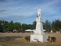
팡라오 광장의 리잘 기념비

.jpg)


저명인사
- 레베카 루스터리오 – 발레카사그 섬에서[citation needed] 태어난 여배우
참조
- ^ a b "Montero reassumes mayoral post; Fuertes calls move 'inciting to sedition'". 2018-09-10. Retrieved September 10, 2018.
- ^ https://halalanresults.abs-cbn.com/local/bohol/panglao
- ^ 팡라오 시 (DILG)
- ^ "2015 Census of Population, Report No. 3 – Population, Land Area, and Population Density" (PDF). Philippine Statistics Authority. Quezon City, Philippines. August 2016. ISSN 0117-1453. Archived (PDF) from the original on May 25, 2021. Retrieved July 16, 2021.
- ^ https://elevation.maplogs.com/poi/panglao_bohol_philippines.319121.html.
- ^ a b c Census of Population (2020). "Region VII (Central Visayas)". Total Population by Province, City, Municipality and Barangay. PSA. Retrieved 8 July 2021.
- ^ https://psa.gov.ph/sites/default/files/City%20and%20Municipal-level%20Small%20Area%20Poverty%20Estimates_%202009%2C%202012%20and%202015_0.xlsx; 발행일: 2019년 7월 10일; 출판사: 필리핀 통계청.
- ^ "Discover Panglao Island Bohol". www.bohol-philippines.com. Retrieved 2019-04-08.
- ^ a b c "Bohol Panglao Island Travel Guide". A1 Online Communication and Advertising. Retrieved 6 September 2012.
- ^ a b c d e "Municipal Profile". Municipality of Panglao. Archived from the original on 2012-09-15. Retrieved 5 September 2012.
- ^ "DOTR-CAAP inaugurates New Bohol-Panglao International Airport". caap.gov.ph. CAAP Official Website. 27 November 2018. Retrieved 7 May 2019.
- ^ "Bohol Festivals Timetable". www.bohol-philippines.com. Retrieved 2019-03-04.
- ^ "Balicasag Island". Dream Native Resort. Archived from the original on 25 June 2015. Retrieved 14 July 2016.
- ^ "Climatological Information for Panglao, Bohol". AmbiWeb GmbH. Retrieved 14 July 2016.
- ^ a b Census of Population and Housing (2010). "Region VII (Central Visayas)". Total Population by Province, City, Municipality and Barangay. NSO. Retrieved 29 June 2016.
- ^ Census of Population (2015). "Region VII (Central Visayas)". Total Population by Province, City, Municipality and Barangay. PSA. Retrieved 20 June 2016.
- ^ Censuses of Population (1903–2007). "Region VII (Central Visayas)". Table 1. Population Enumerated in Various Censuses by Province/Highly Urbanized City: 1903 to 2007. NSO.
- ^ "Province of Bohol". Municipality Population Data. Local Water Utilities Administration Research Division. Retrieved 17 December 2016.
- ^ "Poverty incidence (PI):". Philippine Statistics Authority. Retrieved 28 December 2020.
- ^ https://psa.gov.ph/sites/default/files/NSCB_LocalPovertyPhilippines_0.pdf; 발행일: 2005년 11월 29일; 출판사: 필리핀 통계청.
- ^ https://psa.gov.ph/sites/default/files/2003%20SAE%20of%20poverty%20%28Full%20Report%29_1.pdf; 발행일: 2009년 3월 23일; 출판사: 필리핀 통계청.
- ^ https://psa.gov.ph/sites/default/files/2006%20and%202009%20City%20and%20Municipal%20Level%20Poverty%20Estimates_0_1.pdf; 발행일: 2012년 8월 3일; 출판사: 필리핀 통계청.
- ^ https://psa.gov.ph/sites/default/files/2012%20Municipal%20and%20City%20Level%20Poverty%20Estima7tes%20Publication%20%281%29.pdf; 발행일: 2016년 5월 31일; 출판사: 필리핀 통계청.
- ^ https://psa.gov.ph/sites/default/files/City%20and%20Municipal-level%20Small%20Area%20Poverty%20Estimates_%202009%2C%202012%20and%202015_0.xlsx; 발행일: 2019년 7월 10일; 출판사: 필리핀 통계청.
- ^ "Alona Beach, Panglao Island". A1 Online Communication and Advertising. Retrieved 6 September 2012.
- ^ Philstar, Angeline Valencia (15 August 2012). "Mayor Alcala warns Panglao may become as crowded as Boracay". The Philippine Star. Retrieved 6 September 2012.
- ^ "Panglao Island Diving". A1 Online Communication and Advertising. Retrieved 6 September 2012.
외부 링크
| 위키보야게는 팡라오를 위한 여행 가이드가 있다. |
| 위키미디어 커먼즈에는 팡라오, 보홀과 관련된 미디어가 있다. |
| |||||||||||||||||||||||||||||||||||||||||||||||||||||||
| |||||||||||||||||||||||||||||||||||||||||||||||||||||||
| |||||||||||||||||||||||||||||||||||||||||||||||||||||||
| |||||||||||||||||||||||||||||||||||||||||||||||||||||||
| |||||||||||||||||||||||||||||||||||||||||||||||||||||||
| |||||||||||||||||||||||||||||||||||||||||||||||||||||||
| |||||||||||||||||||||||||||||||||||||||||||||||||||||||
