처치 스트리트 앤드 트리니티 플레이스
Church Street and Trinity Place좌표:40°42°57°N 74°00′26″w/40.7157°N 74.0073°W


처치 스트리트와 트리니티 플레이스는 뉴욕시 로어 맨해튼에서 남북 단일 도로를 형성합니다.북쪽 끝은 Canal Street, 남쪽 끝은 Morris Street로 트리니티 플레이스가 그리니치 스트리트와 합쳐집니다.분단 지점은 리버티 스트리트입니다.
모든 트래픽은 북행입니다.
묘사
Trinity Place는 북동쪽으로 업타운을 달리며 Trinity Church, Trinity and United States Realty Buildings, 주코티 공원을 지나 그리니치 스트리트에서 분기합니다.리버티 스트리트에서는 처치 스트리트(Church Street)가 되어 세계무역센터와 베시 스트리트의 동쪽 경계를 형성합니다.Canal Street에서 남쪽으로 몇 블록 떨어진 Franklin Street에서는 Avenue of the Americas (6번가)가 분기합니다.트리니티 플레이스, 처치 스트리트 및 애버뉴 오브 더 아메리카스는 로어 맨해튼에서 센트럴 [1]파크까지 이어지는 북행 경로를 형성합니다.
처치 스트리트는 월 스트리트에 있는 브로드웨이에 있는 역사적인 고딕 양식의 교구 교회인 트리니티 처치의 이름을 따서 지어졌다.1784년에 연장된 처치 스트리트는 1761년에 존재했다.그 거리의 일부는 교회가 소유했지만 1804년에 [2]: 39 그 도시에 주어졌다.트리니티 플레이스는 또한 1834년에 "럼버 스트리트"와 "롬바드 스트리트"[2]: 101 로 알려지기 전까지 교회의 이름을 따왔다.
1869년 이전에 처치 스트리트의 남쪽 끝은 트리니티 [3]플레이스에서 북쪽으로 세 블록 떨어진 풀튼 스트리트에 있었다.그 후 몇 년 동안 80피트 폭의 연결부가 그 중간 블록을 통해 절단되었고 트리니티 플레이스는 80피트(24m)까지 넓어졌고 남쪽으로 모리스 스트리트까지 확장되었다. 풀튼 스트리트 북쪽 처치 스트리트는 그 당시 폭 40피트(12m)로 남겨졌다.지연과 부패에 시달린 이 작업은 [4]1872년 말까지 완료되었다.
1878년 6월 IRT 6번가 선이 개통되었다.그것은 트리니티 플레이스와 처치 스트리트에서 머레이 스트리트까지 이어졌고, 거기서 서쪽으로 방향을 틀고, 그리고 나서 웨스트 브로드웨이에서 북쪽으로 방향을 틀었다.1938년에 문을 닫고 이듬해 [5]파괴되었다.
8번가 지하철 건설의 일환으로 1929년부터 1932년까지 처치 스트리트는 풀턴 스트리트와 프랭클린 스트리트 사이에 10피트 보도 포함 40피트에서 15피트 보도 포함 90피트로 넓어졌다.서쪽 부동산 경계선만 옮겨졌고, 거리의 동쪽은 [6]온전하게 남아 있었다.
장소
처치 스트리트 90번지에 있는 처치 스트리트 스테이션 우체국은 10048 ZIP 번호와 주변 지역을 취급하고 있으며, 처치 스트리트 [7]북쪽 끝에 있는 캐널 스트리트 스테이션 우체국과 마찬가지로 National Register of Historic Places(NRHP)에 등록되어 있습니다.후자의 바로 남쪽에는 American Telephone & Telegraph Company의 이전 장거리 빌딩이 있으며, 미국 32번가에 위치하고 있으며, 뉴욕시의 지정 랜드마크(NYCL)[8]인 처치 스트리트 310-322번지로도 알려져 있습니다.캐리 빌딩과 세인트. 피터 교회는 뉴욕시의[9] 랜드마크이기도 하다.[7] 또한 NRHP에 등재되어 있다.처치 스트리트는 1765년 세인트루이스의 후면에 접해 있다. 폴[7] 채플, NRHP의 또 다른 뉴욕시의[10] 랜드마크이자 미국 국립역사 랜드마크(NHL)[11]입니다.또한 30 파크 플레이스와 56 레너드 거리에 있는 레지덴셜 타워와 33 토마스 거리에 있는 옛 AT&T 롱 라인 빌딩도 눈에 띈다.
렉터 스트리트 근처 트리니티 플레이스는 트리니티 플레이스 다리 아래를 지나갑니다.LHP Architects에[12] 의해 설계되어 [13]1989년에 완공된 이 다리는 트리니티 플레이스를 [14]가로질러 트리니티 코트 빌딩의 사무실과 유치원을 연결하는 개인 고가 통로입니다.그 건물은 현재 철거되어 교체 공사가 진행 중이며, 개장은 2020년으로 예정되어 있습니다.이 다리는 보존되어 그 [15]때 다시 사용할 수 있게 될 것이다.
그 사이트의 바로 북쪽에 NRHP와 NHL에 등재된 American Stock Exchange 빌딩이 있습니다.그 옆에는 뉴욕시의 공립 고등학교인 리더십&공공서비스 고등학교와 경제·금융 고등학교가 있습니다.
뉴욕시 지하철의 IND 8번가 선(A, C, E 열차)은 풀턴 스트리트 북쪽 처치 스트리트 아래에서 6번가까지 운행됩니다.BMT 브로드웨이 선의 일부(N, R 및 W 열차)는 그리니치 스트리트에서 풀튼 스트리트까지 처치 스트리트와 트리니티 플레이스 아래에 있습니다.9월 11일 테러로 피해를 입은 코틀란트 스트리트 [1]역은 세계무역센터와 인접해 있다.북쪽으로 향하는 M55 버스는 Morris Street에서 Franklin Street까지 Trinity Place/Church Street를 따라 운행되며, 6번가에서 [1]북쪽으로 계속 운행됩니다.
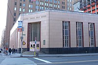
캐널 스트리트 역 우체국
.jpg)


트리니티 플레이스 또는 처치 [16]스트리트에 있는 기타 유적지:
- 트리니티 플레이스 기슭에 있는 모리스 스트리트의 Cunard 빌딩은 트리니티 플레이스와 처치 스트리트(NYCL)[17] 전 구간에서 볼 수 있습니다.
- Edgar Street(NYCL)[18]의 Robert and Anne Dickkey House
- 65 브로드웨이, Exchange Alley와 Rector Street(NYCL)[19] 사이
- Rector Street의 엠파이어 빌딩(NRHP, NYCL)[20][21]
- 처치 스트리트와 브로드웨이 사이의 Vesey Street 20번지 올드 뉴욕 이브닝 포스트 빌딩(NRHP, NYCL)[22][23]
- 처치 스트리트와 브로드웨이 사이의 Vesey Street 14번지 뉴욕 카운티 변호사 협회 빌딩(NRHP, NYCL)[24][25]
- 처치 스트리트와 브로드웨이(NYCL)[26][27] 사이에 있는 23 및 25 파크 플레이스 빌딩
- Church Street와 Broadway 사이 Leonard Street 85번지 Montross & Wilcox Store 주방(NRHP, NYCL)[28][29]
또한 처치 스트리트는 트리베카 사우스 및 트리베카 이스트 히스토리 디스트릭트(NYCL)[30][31]를 통과합니다.
레퍼런스
메모들
- ^ a b c "MTA Neighborhood Maps: Lower Manhattan" (PDF). Metropolitan Transportation Authority of New York State. September 2018. Archived (PDF) from the original on December 6, 2019. Retrieved December 6, 2019.
- ^ a b Moscow, Henry (1978). The Street Book: An Encyclopedia of Manhattan's Street Names and Their Origins. New York: Hagstrom Company. ISBN 978-0-8232-1275-0.
- ^ 페리스, 윌리엄뉴욕시의 지도입니다. 제3판제1권제목 페이지와 볼륨 키(New York: Perris & Browne, 1857)
- ^ 참조:
- Sanborn-Perris Map Co., Limited에서 조사 및 발행한 뉴욕시 보험 지도제1권 (뉴욕: 1894)볼륨 키와 플레이트 7.
- "The Church Street Extension" (PDF). The New York Times. May 6, 1869.
- "Church Street Extension" (PDF). The New York Times. August 13, 1870.
- "Cholera Seeds" (PDF). The New York Times. August 19, 1871.
- "New York and Suburban News: New York" (PDF). The New York Times. December 15, 1872. paragraph 5.
- ^ 참조:
- Jackson, Kenneth T., ed. (1995). The Encyclopedia of New York City. New Haven: Yale University Press. ISBN 0300055366., "고급철도", 2항과 7항.
- G. W. Bromley & Co. (1879). Plate 1 (Map). Atlas of the Entire City of New York. Complete in One Volume. New York: Geo. W. Bromley & E. Robinson.
- "Days of Yore Recalled as 'L' Line Goes". Rochester Democrat and Chronicle. December 5, 1938. p. 9. Retrieved June 30, 2019 – via Newspapers.com
 .
.
- ^ "$9,631,760 Awarded on Church Street". The New York Times. January 6, 1929. "Transit Board Land Ceded To Boroughs". The New York Times. January 28, 1932.
- ^ a b c "National Register Information System". National Register of Historic Places. National Park Service. November 2, 2013.
- ^ "Long Distance Building of the American Telephone & Telegraph Company" (PDF). New York City Landmarks Preservation Commission. October 1, 1991. Retrieved December 6, 2019.
- ^ 참조:
- "Cary Building" (PDF). New York City Landmarks Preservation Commission. August 24, 1982. Retrieved December 6, 2019.
- "St. Peter's Church" (PDF). New York City Landmarks Preservation Commission. December 21, 1965. Retrieved December 6, 2019.
- ^ "Saint Paul's Chapel and Graveyard" (PDF). New York City Landmarks Preservation Commission. August 16, 1966. Retrieved December 6, 2019.
- ^ "St. Paul's Chapel". National Historic Landmark summary listing. National Park Service. September 11, 2007. Archived from the original on April 13, 2014.
- ^ "Trinity Church Bridge". LHP Architects. Archived from the original on December 5, 2019. Retrieved December 5, 2019.
- ^ Louie, Elaine (April 27, 1989). "Currents: A Footbridge From Another Era". The New York Times. Section C, p. 3.
{{cite web}}: CS1 유지보수: 위치(링크) - ^ Dunlap, David W. (March 10, 2017). "A Bridge to Nowhere, 19 Feet 8 Inches Over Lower Manhattan". The New York Times. ISSN 0362-4331. Retrieved February 23, 2020.
- ^ "Trinity Commons". Trinity Church Wall Street. Archived from the original on October 26, 2019. Retrieved December 4, 2019.
- Young, Michael (October 22, 2019). "Work At 74 Trinity Place Nears Completion In The Financial District". New York Yimby. Retrieved December 5, 2019.
- (2013년 8월 이미지 캡처)
- (2016년 8월 촬영 이미지)
- (2019년 6월 촬영 이미지)
- ^ 인터랙티브 맵:
- ^ Breiner, David M. (September 19, 1995). "Cunard Building" (PDF). New York City Landmarks Preservation Commission.
- ^ Shockley, Jay (June 28, 2005). "Robert and Anne Dickey House" (PDF). New York City Landmarks Preservation Commission. Retrieved February 16, 2020.
- ^ Shockley, Jay (December 12, 1995). "American Express Company Building" (PDF). New York City Landmarks Preservation Commission. Retrieved February 16, 2020.
- ^ Shockley, Jay (June 25, 1996). "Empire Building" (PDF). New York City Landmarks Preservation Commission. Retrieved February 16, 2020.
- ^ "Historic Structures Report: Empire Building" (PDF). National Register of Historic Places, National Park Service. January 13, 1983. Retrieved February 16, 2020.
- ^ "New York Evening Post Building" (PDF). New York City Landmarks Preservation Commission. November 23, 1965. Retrieved February 16, 2020.
- ^ "Historic Structures Report: New York Evening Post Building" (PDF). National Register of Historic Places, National Park Service. August 16, 1977. Retrieved February 2, 2020.
- ^ "New York County Lawyers' Association Building" (PDF). New York City Landmarks Preservation Commission. November 23, 1965. Retrieved February 16, 2020.
- ^ "Historic Structures Report: Old New York County Lawyers' Association Building" (PDF). National Register of Historic Places, National Park Service. September 30, 1982. Retrieved February 2, 2020.
- ^ Percival, Marianne (March 13, 2007). "23 Park Place Building" (PDF). New York City Landmarks Preservation Commission.
- ^ Percival, Marianne (March 13, 2007). "25 Park Place Building" (PDF). New York City Landmarks Preservation Commission.
- ^ "Kitchen, Montross & Wilcox Store" (PDF). New York City Landmarks Preservation Commission. November 26, 1974. Retrieved February 16, 2020.
- ^ "Historic Structures Report: 85 Leonard Street" (PDF). National Register of Historic Places, National Park Service. April 23, 1980. Retrieved February 2, 2020.
- ^ Harris, Gale; Urbinelli, Elisa; McHugh, Kevin (December 8, 1992). "Tribeca South Historic District Designation Report" (PDF). New York City Landmarks Preservation Commission.
- ^ Breiner, David M.; Pickart, Margaret M.M. (December 8, 1992). "Tribeca East Historic District Designation Report" (PDF). New York City Landmarks Preservation Commission.
외부 링크


