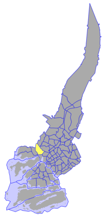
웨스트 브로드웨이
West Broadway루트 맵:
| 라과디아 플레이스 | |||
 | |||
 | |||
| 주인 | 뉴욕 시 | ||
|---|---|---|---|
| 유지 보수자 | 디스크 | ||
| 길이 | 1.4 mi[1] (2.3 km) | ||
| 우편번호 | 10017, 10013, 10012 | ||
| 가장 가까운 지하철역 | 체임버스 스트리트 프랭클린 스트리트 캐널 스트리트 | ||
| 사우스 엔드 | 금융가 비시 스트리트 | ||
| 북단 | 그리니치 빌리지의 워싱턴 스퀘어 사우스 | ||
| 동쪽 | 처치 스트리트(운하 남쪽) 우스터 스트리트(운하 북쪽) | ||
| 서쪽 | 그리니치 스트리트(챔버스 남쪽) 허드슨 스트리트(챔버스 to Leonard) Varick Street(레오나드-운하) 톰슨 스트리트(운하 북쪽) | ||
웨스트 브로드웨이(West Broadway)는 뉴욕시 맨해튼 자치구에 있는 남북으로 트리베카 파크에 의해 두 부분으로 구분된 거리입니다.북쪽은 아메리카 애비뉴(6번가), 워커 스트리트, 트리베카의 비치 스트리트 교차로 근처에 있는 트라이베카 파크에서 시작합니다.그것은 Canal Street를 지나 편도 도로로 북행하고 북쪽으로 한 블록 더 떨어진 Grand Street와 교차로에서 양방향으로 운행된다.그리고 나서 웨스트 브로드웨이는 소호와 그리니치 빌리지 사이의 경계에 있는 휴스턴 스트리트의 북쪽 끝까지 소호를 통과하는 주요 남북 통행로로 운영됩니다.휴스턴 거리 북쪽에는 라과디아 플레이스로 지정되어 있으며, 워싱턴 스퀘어 사우스까지 계속됩니다.
웨스트 브로드웨이의 남쪽 부분은 트라이베카[note 1] 파크에서 트리베카 인근을 지나 파크 플레이스에서 끝난다.2001년 9월 11일 테러가 일어나기 전에 웨스트 브로드웨이는 남쪽으로 계속 나아가 세계무역센터 부지로 들어가 베시 스트리트에서 끝이 났습니다.그것은 한때 "로튼 로우"[2]로 여겨졌다.
역사
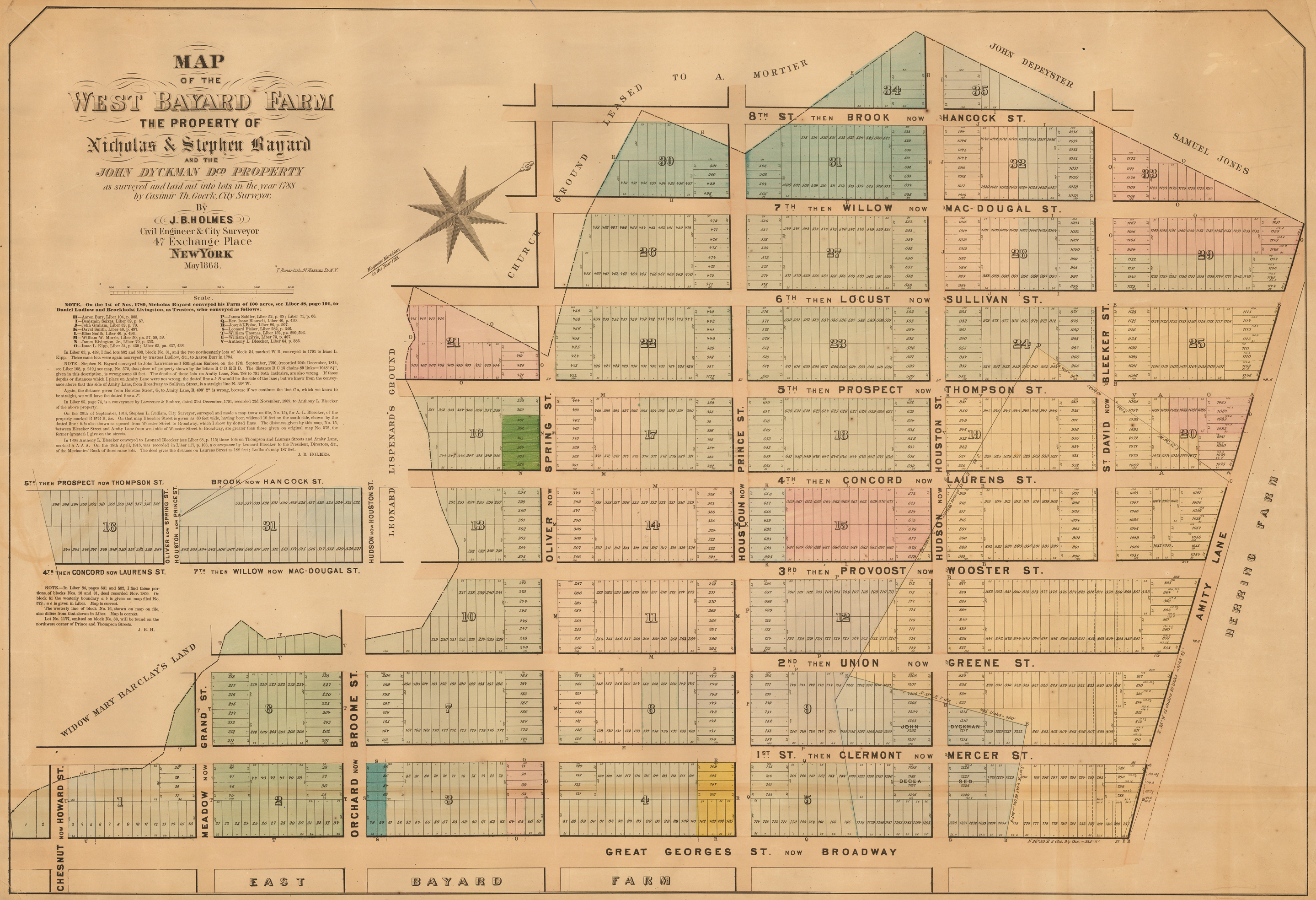
웨스트 브로드웨이는 한때 두 거리였다.캐널 스트리트 아래 채플 스트리트, 그 위 로렌스 스트리트.
1750년대 초, 트리니티 교회는 킹스 팜으로 알려진 그 소유지에 허드슨 강과 맨해튼 하부에 있는 브로드웨이 사이에 도로망을 설치했다.비슷한 시기에 트리니티는 킹스 칼리지(현 컬럼비아 대학교)를 설립하고 바클레이, 머레이, 처치 스트리트와 인접한 부지를 [3]캠퍼스로 기부했는데, 이 부지는 [4]1760년에 학교가 이전했다.1755년 지도에 따르면, "채플 스트리트"는 바클레이에서 워렌스 스트리트 바로 옆을 지나 도시의 [5]북쪽 끝을 보호하는 울타리에서 끝나는 이 그리드의 일부였다.1760년대에 트리니티 교회는 풀튼 스트리트와 리드 스트리트 사이의 거리를 도시에 양도했고 리드 스트리트 북쪽 땅의 소유주인 앤서니 럿거스의 상속자들은 그들의 재산을 거리와 부지에 지도화했다.1790년대에 채플 스트리트는 등급이 매겨져 머레이에서 리드 스트리트까지 포장되었고 레너드 [6]스트리트까지 확장되었다.
1831년 뉴욕시 평의회는 바클레이와 머레이 거리 사이의 채플 거리 두 블록의 이름을 "College Place"[7]로 바꾸었다.10년 후 채플 스트리트는 브로드웨이 자체의 [8]교통 혼잡을 줄이기 위해 이스트 브로드웨이와 같은 목적으로 "웨스트 브로드웨이"로 이름이 바뀌었지만, 두 이름 모두 20년 이상 사용되었다.1835년 지도에서는 채플 스트리트를 [9]"웨스트 브로드웨이"라고 불렀지만 1850년 지도에서는 "채플 스트리트"[10][note 2]라고 불렀습니다.1850년경 머레이에서 챔버스 스트리트까지의 두 블록은 College [11]Place의 일부로 이름이 바뀌었다.

Laurns Street는 다른 그리드에 속해 있었다.1788년, Bayard 가족은 농장을 블록과 판매용 부지로 나누면서 브로드웨이와 평행하게 8개의 길과 7개의 교차로를 만들었다.몇 년 후, 번호가 매겨진 거리는 이름이 붙여졌고, 세기가 바뀔 무렵에는 헨리 로렌스를 포함한 독립 전쟁 장교들을 위해 다시 이름이 바뀌었다.[12][13]1830년대에 이 지역은 "로튼 로우"[14]라는 별명이 붙은 홍등가였고, 1860년대에는 빈곤, 오물, 폭력 범죄로 시달렸다.1869년과 1870년에 로렌스 거리를 넓히고 워싱턴 스퀘어[15] 공원까지 북쪽으로 한 블록 연장하자는 1860년 제안이 실행되었다.또한, 웨스트 브로드웨이에서 5번가를 연결하는 도로가 건설되어 워싱턴 스퀘어 공원으로 마차 교통을 도입하였고,[16][17] 로렌스 스트리트는 이미지를 개선하기 위해 공식적으로 사우스 5번가로 개명하였다.
1860년 로렌스 거리를 넓히자는 제안은 칼리지 플레이스를 넓히고 남쪽으로 그리니치 [18][note 3]거리까지 확장하자는 제안을 동반했다.그것은 로렌스 스트리트와 사우스 5번가 둘 [20]다 웨스트 브로드웨이의 일부가 [19]된 1895년에 마침내 공연되었다.
라과디아 플레이스
1967년 휴스턴 거리 북쪽의 구역은 피오렐로 H. [21]라과디아 전 시장의 이름을 따서 "라과디아 플레이스"로 개명되었다.웨스트 3번가와 블리커 거리 사이에 있는 라과디아 가든이 특징이며, 라과디아라는 별명으로 "작은 꽃"의 위탁 동상이 포함되어 있습니다.닐 에스턴에 의해 조각되고 건축가 루스 샤피로가 디자인한 받침대가 있는 이 청동상은 1994년에 헌정되었으며 라과디아 [22]플레이스의 친구들에 의해 도시에 위탁되어 기증되었다.이 조각상은 로버트 모지스가 5번가 사우스 [23]가와 로어 맨하탄 고속도로를 연결하는 연결선 역할을 하기 위해 수년 전에 건물을 허물었던 거리의 그 부분을 미화하고 되살리기 위한 프로젝트의 일환으로 의뢰되었다.
교통.
현재의
뉴욕시 버스 시스템의 남쪽 방향 M20 버스는 웨스트 브로드웨이를 통해 Varick Street와 Leonard Street와의 오거리부터 Chambers [24]Street까지 운행됩니다.IRT 브로드웨이 - 7번가 선(1, 2, 3열차)의 프랭클린 스트리트 및 챔버스 스트리트 역은 웨스트 [25]브로드웨이에 있습니다.
예전의
6번가 고가, 정식 명칭은 메트로폴리탄 고가 철도가 1878년 6월 5일에 개통되었습니다.머레이 스트리트에서 아미티([26]웨스트 3번) 스트리트로 방향을 튼 머레이 스트리트에서 6번가로 방향을 튼 College Place, West Broadway 및 South Fifth Avenue 위로 운행되었습니다.6번가 엘은 1938년 12월 4일 버려지고 1939년 파괴되어 지하 IND 8번가 [27]라인으로 대체되었다.
레퍼런스
참고 사항
- ^ 인근은 "TriBeca"이지만, 이 공원은 시의 공원 부서인 "트리베카 공원"으로 불린다."트리베카 파크" 뉴욕시 공원 및 레크리에이션 부서 참조
- ^ 비슷하게, 1837년 광고는 "웨스트 브로드웨이"를 가리킨다.1857년 뉴스 스토리는 "채플 스트리트""The Rescue of Auguste Parot" (PDF). The New York Times. September 1, 1857. paragraph 4 ( )에 관한 것이다"Highly Concentrated Compound". New York Herald. February 17, 1837. p. 4, col. 2, third advertisement, fourth line from bottom.
- ^ 비슷한 제안이 10년 전에 있었다.("Common Council". New York Herald. November 9, 1850. p. 7, col. 2, "Board of Assistant Aldermen", "Reports of Committees", paragraph 3.
Committee on Streets…to non-concur in resolution to employ a surveyor to estimate the expense of extending and widening College Place from Barclay to Greenwich Streets. Adopted.
)
인용문
- ^ Google (January 12, 2017). "West Broadway and LaGuardia Place" (Map). Google Maps. Google. Retrieved January 12, 2017.
- ^ "West Broadway: once a slum called "Rotten Row"". Ephemeral New York.
- ^ Koeppel, Gerard (2015). City on a Grid. Philadelphia, Pennsylvania: Da Capo Press. p. 11. ISBN 9780306822841.
…Trinity Church in the early 1750s laid out a portion of its wedge of land between Broadway and the Hudson River into a small neighborhood of rectangular blocks around its newly chartered King's College, at the town's then suburban fringe between Barclay and Murray Streets, west of Church Street. This marked the birth of both a great school (now Columbia University) and the idea of rectilinear planning on Manhattan.
- ^ "250 Years". Columbia College Today. March 2004. Archived from the original on December 25, 2016. Retrieved February 16, 2017.
1755: Trinity Church presents King’s College with a parcel of land bordered by Church Street, Barclay Street, Murray Street and the Hudson River, and intersected by Park Place.… 1760: King’s College moves to a three-acre site at Park Place, overlooking the Hudson River. The campus comprises a three-story stone building, a private park and 24 rooms total for living quarters, a chapel, classrooms and dining.
- ^ Maerschalck, Francis W. (1755). "A plan of the city of New York from an actual survey, anno Domini, M[D]CC,LV by F. Maerschalck, city survey[o]r". Library of Congress. G. Duyckinck.
- ^ Harris, Gale; Urbanelli, Elisa; McHugh, Kevin (December 1992). Tribeca South Historic District Designation Report (PDF) (Report). New York City Landmarks Preservation Commission. pp. 5 (paragraph 2) and 44 (paragraph 1).
- ^ Minutes of the Common Council of the City of New York 1784–1831. Vol. 19. New York: City of New York. 1917. p. 706 (May 9, 1831).
A Petition of the Trustees of Columbia College and owners of property in the vicinity of Murray Barclay & Chaple streets praying that, that part of Chaple street lying between Murray and Barclay street may be called "College Place" was read and the prayer of the Petition granted.
- ^ Moscow, Henry (1978). The Street Book: An Encyclopedia of Manhattan's Street Names and Their Origins. New York: Hagstrom Company. ISBN 978-0-8232-1275-0., 페이지 110
- ^ Burr, David H. (1834–36). "1835 David Burr Map of New York City". Geographicus Rare Antique Maps. Brooklyn, New York. Archived from the original on March 4, 2016. Retrieved March 2, 2017.
- ^ Mitchell, Samuel Augustus. "1850 Mitchell Map of New York City". Geographicus Rare Antique Maps. Brooklyn, New York. Archived from the original on March 4, 2016. Retrieved March 2, 2017.
- ^ "New Map of the City of New-York". The New York Public Library Digital Collections. New York: Serrell & Perkins. 1850.
- ^ Koeppel, Gerard (2015). City on a Grid. Philadelphia, Pennsylvania: Da Capo Press. pp. 12–16. ISBN 9780306822841.
- ^ Nevius, James (January 14, 2016). "How West Broadway Became One of NYC's Most Important Streets". Curbed New York. Vox Media, Inc. Archived from the original on August 6, 2016. Retrieved March 3, 2017.
[It's the younger Laurens's] patriotic father, Henry, who is the namesake of Laurens Street…. The elder Laurens was president of the Continental Congress and was held as a prisoner in the Tower of London during the Revolution—the only American ever held there.
- ^ Gilfoyle, Timothy J. (1992). City of Eros. New York: W. W. Norton & Company. p. 47. ISBN 0393311082.
Along Church and Chapel Streets, continuing north of Canal Street into Laurens Street (Rotten Row, as it was nicknamed), were many expensive brothels.
- ^ "The Board of Councilmen". The New York Times. February 21, 1860.
The Street Committee was requested to report upon the utility of widening Laurens-street twenty-five feet on the westerly side, and also of extending it to Fourth street.
- ^ "South Fifth Avenue". New York Herald. October 16, 1870. p. 10.
- ^ "Our Ruined Squares" (PDF). The New York Times. September 29, 1871.
The opening of a carriage communication between the north and south sides of this square was perhaps not to be avoided. But was it therefore necessary to destroy the square utterly?
- ^ "The Board of Councilmen". The New York Times. February 21, 1860.
[A resolution] to have College-place widened on the westerly side, from Chambers-street to Barclay, and extended to Fulton-street [was referred to the Committee on Streets].
- ^ "Like A Cyclone District" (PDF). The New York Times. February 7, 1895.
- ^ "Aldermen Long in Session" (PDF). The New York Times. April 10, 1895. Last paragraph.
- ^ Williams, Keith (14 December 2017). "The History of East and West Broadway". The New York Times. Retrieved 25 January 2020.
- ^ 피오렐로 H. 라 과르디아 뉴욕시 공원 및 레크리에이션부
- ^ 피오렐로 H. 라과디아 동상 뉴욕시 공원 및 레크리에이션부
- ^ "Manhattan Bus Map" (PDF). Metropolitan Transportation Authority. July 2019. Retrieved December 1, 2020.
- ^ "Subway Map" (PDF). Metropolitan Transportation Authority. September 2021. Retrieved September 17, 2021.
- ^ "Establishing Rapid Transit" (PDF). The New York Times. June 6, 1878.
- ^ Jackson, Kenneth T., ed. (2010). The Encyclopedia of New York City (2nd ed.). New Haven: Yale University Press. pp. 405, 408. ISBN 978-0-300-11465-2.
외부 링크
- 뉴욕 송라인: 웨스트 브로드웨이, 가상 도보 여행
- "Walking Tour: SoHo/TriBeCa". The New York Times. Retrieved 2013-06-08.
- "West Broadway". Forgotten NY. Retrieved 2013-06-08.

