아파야오
Apayao아파야오 | |
|---|---|
| 아파야오 현 | |
 필리핀의 위치 | |
| 좌표:17°45°N 동경 121°15°E/17.75°N 121.25°E좌표: 17°45′N 121°15′E / 17.75°N 121.25°E/ ′ | |
| 나라 | 필리핀 |
| 지역 | 코딜레라 행정구 |
| 설립됨 | 1995년 5월 8일 |
| 자본 | 카부가오* |
| 최대 시 | 코너 |
| 정부 | |
| • 주지사 | 엘리너 B베그탕(PDP-라반) |
| • 부지사 | 레미 알바노 (LP) |
| • 입법부 | 아파야오 지방 이사회 |
| 면적 | |
| • 합계 | 4,413.35km2(1,704.00 sq mi) |
| 면적 순위 | 81명 중 27위 |
| 최고 고도 (폐장 마운트) | 1,921 m(6,302 ft) |
| 인구 (1998년 인구조사) | |
| • 합계 | 124,366 |
| • 견적 (2020) | 123,898[2] |
| • 순위 | 81점 만점에 78점 |
| • 밀도 | 28/km2(73/sq mi) |
| • 밀도 순위 | 81위 중 81위 |
| 사단 | |
| • 독립 도시 | 0 |
| • 구성요소 도시 | 0 |
| • 지방 자치 단체 | |
| • 바랑게이 | 133 |
| • 구역 | 아파야오의 입법구 |
| 시간대 | UTC+8(PHT) |
| 우편번호 | 3807–3814 |
| IDD : 지역번호 | +63 (0)74 |
| ISO 3166 코드 | PH-APA |
| 구어어군 | |
| 웹사이트 | www |
| * 가부가오는 루나에 신설된 정부기관에서 많은 업무를 수행하고 있지만 공식적으로는 인정받는 수도이자 정부의 자리다. | |
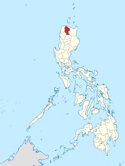
아파야오(일로카노:프로빈시아 티 아파야오; 타갈로그어: 랄라위건 ng 아파야오)는 루손의 코딜레라 행정구에 있는 필리핀의 육지로 둘러싸인 주이다.수도는 가부가오 입니다.
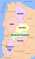
성은 북쪽과 동쪽으로는 카가얀, 서쪽으로는 아브라와 일로코스 노르트, 남쪽으로는 칼링가와 접한다.1995년 이전에 칼링가와 아파야오는 칼링가-아파야오라는 단일 지방을 구성했는데, 이는 개별 민족 집단의 요구를 더 잘 충족시키기 위해 분할되었다.
인구 124,366명(2020년 인구조사 기준)의 면적은 4,413.35km(1,704.00평방mi)로,[1] 아파야오는 필리핀에서 인구가 가장 적은 주이다.
역사
스페인 시대
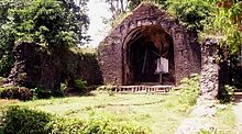
당시 카가얀의 일부였던 아파야오는 [4]코르딜레라스의 스페인인들이 침투한 초기 지역들 중 하나였지만, 이네그 부족이 거주하던 이 지역은 19세기 후반까지 대체로 스페인의 지배를 받지 못하고 있었다.1610년 초에 도미니카 연방교도들은 지금의 푸돌 마을에 사명을 세웠다.1684년, 다시 민중의 개종을 시도하고 지금의 가부가오에 교회를 세웠다.
그 후 스페인 당국은 1891년 카가얀에 아파야오와 카부가오의 코만단시아를 설립할 수 있었고,[4][5][6] 현재 아파야오의 서쪽과 동쪽 지역을 커버했다.그러나, 코만단시아는 완전한 통제권을 가져오지 못했고 스페인 정부는 이 지역에 대한 느슨한 통제만을 유지했다.
미국 시대
미국인들은 법 제1876호가 제정되면서 1908년 8월 13일 마운틴 주를 세웠다.아파야오는 암부라얀, 벤게트, 본토크, 이푸가오, 칼링가, 레판토와 함께 이 새로운 지방의 하위 프로시저가 되었다.[5][6][7]
제2차 세계 대전
이 구간은 확장이 필요하다.덧셈으로 도움도 된다. (2015년 1월) |
1942년 일본 제국군이 아파야오에 입성하여 제2차 세계대전 당시 3년간의 지방 점령에 들어갔다.[further explanation needed]필리핀 영연방군 제1·2·12·15·16보병사단과 미 육군 제11·66보병연대의 군대는 코딜레란 게릴라의 지원을 받아 1945년 일본군을 몰아냈다.[further explanation needed]
칼링가-아파야오 생성 및 분할
1966년 6월 18일, 공화국법 제4695호가 제정되면서 거대한 산성이 네 개의 성으로 분할되었다.네 개의 성은 벤게트, 본토크('산맥성')와 칼링가아파야오, 이푸가오였다.[6][8]칼링가아파야오는 이푸가와 함께 1972년 카가얀 계곡 지역의 한 주가 되었다.[8]
1987년 7월 15일 코딜레라 행정구역이 설치되고 칼링가-아파야오가 그 지방 중 하나가 되었다.[6][8][9][10]
마침내 1995년 2월 14일, 공화국법 7878호가 통과되면서 칼링가-아파야오는 두 개의 독립된 지방으로 분할되었다.[6][8][11]
생물다양성과 생물권 보전
아파야오는 생물학적으로 다양하다.도는 139종의 조류가 서식하고 있는데, 이 중 61종의 조류가 서식하고 있으며 4종의 조류가 멸종위기에 처해 있다.[12]또 토착민들이 먹는 야생식품 식물 43종과 약용식물 50종을 보유하고 있다.[13]이 지방에는 멸종위기에 처한 루피나무, 로라나 디프테로카프 나무, 라플레시아 꽃, 흰날개 나는 여우가 서식하고 있다.[12]
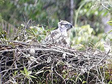
필리핀 독수리재단은 수세기 동안 거대한 독수리들이 이 지역을 배회하고 있다는 보고가 있은 후 2011년 아파야오에서 독수리 탐사에 착수했다.[14]2013년 3월 22일 과학자들은 칼라나산 저지대 숲 인근 루손 섬에서 멸종위기에 처한 필리핀 국새 독수리의 거점을 발견했다.[15]2015년 1월, 칼라나산 마을은 3,000헥타르의 산림을 보호하는 프로그램을 시작했다.[16]또한, 아파야오 지방은 전국에서 승인된 산림 토지 이용 계획(FLUP)을 가진 극소수 지역 중 하나이다.[17]2015년 7월 필리핀 아파야오에서 첫 활동 중인 독수리 둥지가 발견됐다.[14]
2018년 7월 9일,[17] 아파야오 도가 유네스코 생물권보전지역이 되겠다는 뜻을 밝혔다.28만6000ha가 넘는 처녀림을 소유하고 있는 도는 부지 선포를 서두르기 위해 미 외교청 산하에 4명의 인원을 파견해 미국 내 연수에도 나선 점에 주목했다.[18]2019년 1월 16일, 도는 "비문을 위한 레그워크"를 실시하고 있다고 발표했다.[19]
지리

아파야오는 기본적으로 많은 강이 가로지르는 코딜레라 센트럴 산맥 안에 위치해 있다.도는 코딜레라 행정구 북단을 구성하는 4,413.35km(1,704.00평방mi)[20]의 면적에 걸쳐 있으며, 북쪽과 동쪽은 카가얀, 서쪽은 일로코스 노르트, 남서쪽은 아브라, 남쪽은 칼링가(Kalinga)로 경계를 이루고 있다.
평야와 계곡은 농사를 짓는데 쓰인다.아파야오는 기본적으로 농경지로 이루어져 있다.[citation needed]
기후
지방의 일반적인 기후는 코로나의 제3종 분류에 속한다.11월부터 4월까지 비교적 건조하고 습한 계절이 특징이며, 나머지 기간에는 습한 것이 특징이다.12월에서 2월 사이에 가장 많은 비가 내리는 반면 5월은 가장 따뜻하다.
행정 구역
아파야오는 7개의 자치구로 이루어져 있으며, 모두 단독입법구역으로 구성되어 있다.[20]
|
| |||||||||||||||||||||||||||||||||||||||||||||||||||||||||||||||||||||||||||||||||||||||||||||||||||||||||||||||||||||||||||||||||||||||||||||||||
바랑게이
도내 7개 자치단체는 총 133개의 바랑게이로 구성되며, 2015년 코너의 바랑게이 말라마가 가장 많은 인구를 보유하고 있으며, 칼라나산의 엘르아자르가 가장 적은 인구를 보유하고 있다.[21][20]
인구통계학
2020년 인구조사에서 아파야오 인구는 12만4366명으로, 밀도는 평방킬로미터당 28명 또는 평방마일당 73명이었다.
| 연도 | Pop. | ±% p.a. |
|---|---|---|
| 1918 | 9,787 | — |
| 1939 | 15,614 | +2.25% |
| 1948 | 19,357 | +2.42% |
| 1960 | 29,601 | +3.60% |
| 1970 | 49,652 | +5.30% |
| 1975 | 61,115 | +4.25% |
| 1980 | 70,681 | +2.95% |
| 1990 | 74,720 | +0.56% |
| 1995 | 83,660 | +2.14% |
| 2000 | 97,129 | +3.25% |
| 2007 | 103,633 | +0.90% |
| 2010 | 112,636 | +3.08% |
| 2015 | 119,184 | +1.08% |
| 2020 | 124,366 | +0.84% |
| 출처: 필리핀 통계청 | ||

2000년 인구조사 기준 일로카노스는 전체 지방인구 9만7058명의 4만9328명(50.82%)을 차지했고, 이삭은 2만9071명(29.95%)으로 거의 1/3에 달했다.그 외 도내 인종은 말라위그 3580명(3.69%), 이스네그(3.48%), 칼링가 2992명(3.08%), 칸카나이 1208명(1.24%), 본토크 1014명(1.04%), 이발로이 979명(1.01%)[26] 순이었다.
이코노미
아파야오는 농업 생산에 전념하고 있으며,[34] [35]특히 팔레, 옥수수, 커피, 뿌리 작물, 야채와 같은 식량과 산업 작물을 생산한다.생산된 과일은 란존, 감귤, 바나나, 파인애플, 두리안, 산톨,[36] 람부탄, 코코넛, 망고스틴 등이다.2011년 쌀 생산량은 총 98,489톤이다.[34]아파야오의 일부 지역은 쌀 테라스의 고향이다.[37]
경제활동도 돼지, 카라바오, 소, 염소, 양과 같은 가축과 가금류의 번식을 기반으로 한다.그 외 추가 투자에는 제조, 식품 가공, 가구, 공예, 집기 제작 등이 포함된다.[38]
산업통상자원부 최신기록에 따르면 도내 기존 산업은 가구, 의류공예, 식품가공, 선물 및 가정용품, 농업지원 등이 있다.
아파야오 사람들은 또한 바구니, 수공예, 직물 짜기의 풍부한 전통을 가지고 있다.[39]
참조
- ^ a b "List of Provinces". PSGC Interactive. Makati, Philippines: National Statistical Coordination Board. Archived from the original on 19 April 2016. Retrieved 5 March 2020.
- ^ "POPULATION PROJECTIONS BY REGION, PROVINCE, CITIES AND MUNICIPALITIES, 2020-2025". www.doh.gov.ph. Department of Health. August 27, 2020. Retrieved October 16, 2020.
- ^ a b Census of Population (2020). Highlights of the Philippine Population 2020 Census of Population. PSA. Retrieved 8 July 2021.
- ^ a b "History". Province of Cagayan (Official Website of the Provincial Government of Cagayan). Retrieved 18 January 2015.
- ^ a b "Benguet History". Province of Benguet (official website). Archived from the original on 19 October 2014. Retrieved 1 January 2015.
- ^ a b c d e "Historical Background". Provincial Government of Apayao (official website). Archived from the original on 4 January 2015. Retrieved 18 January 2015.
- ^ Ingles, Raul Rafael (2008). 1908 :The Way it Really was : Historical Journal for the UP Centennial, 1908-2008. Diliman, Quezon City: University of the Philippines Press. p. 330. ISBN 978-9715425803. Retrieved 19 January 2015.
- ^ a b c d Lancion, Jr., Conrado M.; de Guzman, Rey (cartography) (1995). "The Provinces". Fast Facts about Philippine Provinces (The 2000 Millenium ed.). Makati, Metro Manila: Tahanan Books. pp. 76, 86, 108. ISBN 971-630-037-9. Retrieved 16 January 2015.
- ^ "Regional Profile: Cordillera Administrative Region (CAR)". CountrySTAT Philippines. Archived from the original on 22 October 2014. Retrieved 18 September 2014.
- ^ "The Cordillera Administrative Region (CAR)". Department of Agriculture. Retrieved 18 September 2014.
- ^ "Republic Act No. 7878 - An Act Converting the Sub-provinces of Kalinga and Apayao into Regular Provinces to be Known as the Province of Kalinga and the Province of Apayao, Amending for the Purpose Republic Act No. 4695". Chan Robles Virtual Law Library. Retrieved 18 January 2015.
- ^ a b Ranada, Pia (July 23, 2015). "Apayao: Where ethnic tradition is saving the Philippine Eagle". Rappler. Retrieved 2020-06-21.
- ^ Angagan, J. (2009). "Indigenous knowledge and biodiversity conservation practices in Apayao rice terraces [Philippines]: a gender lens perspective". Journal of ISSAAS [International Society for Southeast Asian Agricultural Sciences] (Philippines).
- ^ a b Ranada, Pia (July 14, 2015). "First active Philippine eagle nest in Luzon found in Apayao". Rappler. Retrieved 2019-02-26.
- ^ "Eagle Sightings in Apayao". philippineeaglefoundation.org. Archived from the original on 2019-02-27. Retrieved 2019-02-26.
- ^ "Bayanihan.org". bayanihan.org.
- ^ a b Dumlao, Artemio (July 9, 2018). "Apayao eagle habitat eyed as Unesco protected area". The Philippine Star. Retrieved 2019-02-26.
- ^ "Gov Bulut wants Calanasan Philippine Eagle sanctuary declared as protected area Politiko North Luzon". July 27, 2018.
- ^ Geminiano, Pamela Mariz (January 16, 2019). "Apayao eyes UNESCO biosphere reserve title to save PH eagles". Philippines News Agency. Retrieved 2019-02-26.
- ^ a b c d "Province: Apayao". PSGC Interactive. Quezon City, Philippines: Philippine Statistics Authority. Retrieved 8 January 2016.
- ^ a b Census of Population (2015). "Cordillera Administrative Region (CAR)". Total Population by Province, City, Municipality and Barangay. PSA. Retrieved 20 June 2016.
- ^ Census of Population and Housing (2010). "Cordillera Administrative Region (CAR)". Total Population by Province, City, Municipality and Barangay. NSO. Retrieved 29 June 2016.
- ^ Census of Population (2020). "Cordillera Administrative Region (CAR)". Total Population by Province, City, Municipality and Barangay. PSA. Retrieved 8 July 2021.
- ^ Census of Population (2015). Highlights of the Philippine Population 2015 Census of Population. PSA. Retrieved 20 June 2016.
- ^ Census of Population and Housing (2010). Population and Annual Growth Rates for The Philippines and Its Regions, Provinces, and Highly Urbanized Cities (PDF). NSO. Retrieved 29 June 2016.
- ^ a b "Apayao: Three Out of Five Academic Degree Holders Were Females; Table 4. Household Population by Ethnicity and Sex: Apayao, 2000". Philippine Statistics Authority. 12 July 2002. Archived from the original on 9 June 2006. Retrieved 17 December 2015.
- ^ "Poverty incidence (PI):". Philippine Statistics Authority. Retrieved 28 December 2020.
- ^ https://psa.gov.ph/sites/default/files/NSCB_LocalPovertyPhilippines_0.pdf; 발행일: 2005년 11월 29일; 출판사: 필리핀 통계청.
- ^ https://psa.gov.ph/sites/default/files/2009%20Poverty%20Statistics.pdf; 발행일: 2011년 2월 8일; 출판사: 필리핀 통계청.
- ^ https://psa.gov.ph/sites/default/files/Table%202.%20%20Annual%20Per%20Capita%20Poverty%20Threshold%2C%20Poverty%20Incidence%20and%20Magnitude%20of%20Poor%20Population%2C%20by%20Region%20and%20Province%20%20-%202006%2C%202009%2C%202012%20and%202015.xlsx; 발행일: 2016년 8월 27일; 출판사: 필리핀 통계청.
- ^ https://psa.gov.ph/sites/default/files/Table%202.%20%20Annual%20Per%20Capita%20Poverty%20Threshold%2C%20Poverty%20Incidence%20and%20Magnitude%20of%20Poor%20Population%2C%20by%20Region%20and%20Province%20%20-%202006%2C%202009%2C%202012%20and%202015.xlsx; 발행일: 2016년 8월 27일; 출판사: 필리핀 통계청.
- ^ https://psa.gov.ph/sites/default/files/Table%202.%20%20Annual%20Per%20Capita%20Poverty%20Threshold%2C%20Poverty%20Incidence%20and%20Magnitude%20of%20Poor%20Population%2C%20by%20Region%20and%20Province%20%20-%202006%2C%202009%2C%202012%20and%202015.xlsx; 발행일: 2016년 8월 27일; 출판사: 필리핀 통계청.
- ^ https://psa.gov.ph/sites/default/files/Table%202.%20%20Updated%20Annual%20Per%20Capita%20Poverty%20Threshold%2C%20Poverty%20Incidence%20and%20Magnitude%20of%20Poor%20Population%20with%20Measures%20of%20Precision%2C%20by%20Region%20and%20Province_2015%20and%202018.xlsx; 발행일: 2020년 6월 4일; 출판사: 필리핀 통계청.
- ^ a b "DA allots P278M for irrigation, agri projects in Apayao". Official Gazette of the Republic of the Philippines. Department of Agriculture. 15 June 2012. Retrieved 23 April 2016.
Last year, Apayao produced a total of 98,489 metric tons of palay (paddy rice), according to the DA’s Bureau of Agricultural Statistics. The volume is equivalent to 64,017 MT of rice at 65 percent milling recovery.
- ^ Vanzi, Sol Jose (28 April 1998). "Apayao Secret: Drought-Resistant Corn". Newsflash.Org. Retrieved 23 April 2016.
- ^ Galvez, James Konstantin (14 January 2014). "Government agri program to promote Apayao's wild fruits". The Manila Times. Retrieved 23 April 2016.
The province of Apayao is host to some of the country’s indigenous crops including: lubeg, bignay, bignay kalabaw, calumpit, saging matsing, other than the fruit-bearing trees like durian, marang, lanzones, rambutan, pineapple, mangosteen, coconut, santol, among others.
- ^ Malingan, Jamie Joie. "Survival and Identity: The Cordillera Rice Terraces in the 21st century". pia.gov.ph. Retrieved 2020-06-21.
- ^ "Apayao producers open new markets in cities". Philippine Information Agency. 5 December 2009. Archived from the original on 20 May 2018. Retrieved 23 April 2016.
- ^ Ocampo, R. O. (2009). "Tapping the potentials of the weaving industry in Apayao [Philippines]". Journal of ISSAAS [International Society for Southeast Asian Agricultural Sciences] (Philippines).
외부 링크
 위키미디어 커먼스의 아파야오(도) 관련 매체
 OpenStreetMap에서 Apayao와 관련된 지리 데이터


