그랜드 애비뉴 - 뉴타운 역
Grand Avenue–Newtown station 그랜드 애비뉴-뉴타운 | ||||||||||||||||||||||||||||||||||||||||||||||||||||||||||||||||||||
|---|---|---|---|---|---|---|---|---|---|---|---|---|---|---|---|---|---|---|---|---|---|---|---|---|---|---|---|---|---|---|---|---|---|---|---|---|---|---|---|---|---|---|---|---|---|---|---|---|---|---|---|---|---|---|---|---|---|---|---|---|---|---|---|---|---|---|---|---|
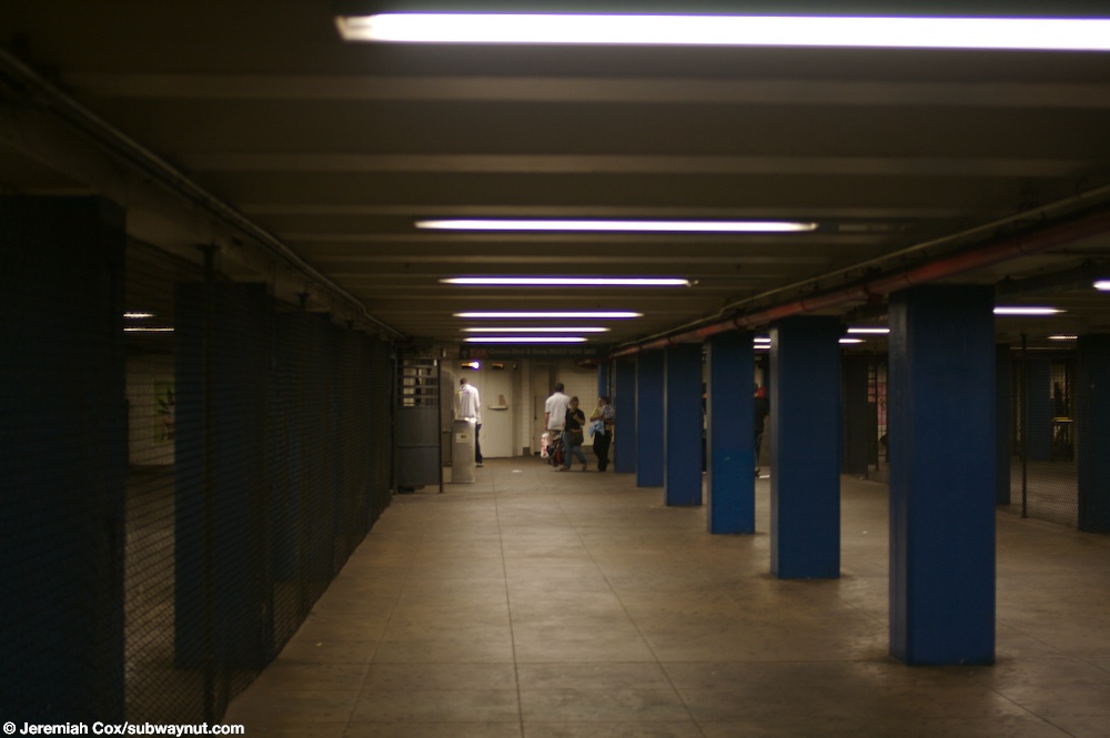
 북행 승강장 전경 | ||||||||||||||||||||||||||||||||||||||||||||||||||||||||||||||||||||
| 관측소통계 | ||||||||||||||||||||||||||||||||||||||||||||||||||||||||||||||||||||
| 주소. | 그랜드 애비뉴, 브로드웨이 & 퀸즈 대로 엘름허스트, 뉴욕 11373[1] | |||||||||||||||||||||||||||||||||||||||||||||||||||||||||||||||||||
| 자치구 | 퀸즈 | |||||||||||||||||||||||||||||||||||||||||||||||||||||||||||||||||||
| 로캘 | 엘름허스트 | |||||||||||||||||||||||||||||||||||||||||||||||||||||||||||||||||||
| 좌표 | 40°44'13 ″N 73°52'39 ″W / 40.73695°N 73.877521°W | |||||||||||||||||||||||||||||||||||||||||||||||||||||||||||||||||||
| 나누기 | B(IND)[2] | |||||||||||||||||||||||||||||||||||||||||||||||||||||||||||||||||||
| 선 | IND 퀸즈 대로 선 | |||||||||||||||||||||||||||||||||||||||||||||||||||||||||||||||||||
| 서비스 | E(심야) F(심야) R(심야를 제외한 모든 시간) | |||||||||||||||||||||||||||||||||||||||||||||||||||||||||||||||||||
| 트랜짓 | | |||||||||||||||||||||||||||||||||||||||||||||||||||||||||||||||||||
| 구조. | 지하 | |||||||||||||||||||||||||||||||||||||||||||||||||||||||||||||||||||
| 플랫폼 | 측면 플랫폼 2개 | |||||||||||||||||||||||||||||||||||||||||||||||||||||||||||||||||||
| 타는 곳 | 4 | |||||||||||||||||||||||||||||||||||||||||||||||||||||||||||||||||||
| 다른 정보 | ||||||||||||||||||||||||||||||||||||||||||||||||||||||||||||||||||||
| 열린 | 1936년 12월 31일, 전 | |||||||||||||||||||||||||||||||||||||||||||||||||||||||||||||||||||
| 반대로... 방향 갈아타다 | 네. | |||||||||||||||||||||||||||||||||||||||||||||||||||||||||||||||||||
| 교통. | ||||||||||||||||||||||||||||||||||||||||||||||||||||||||||||||||||||
| 2022 | 3,588,300[3] | |||||||||||||||||||||||||||||||||||||||||||||||||||||||||||||||||||
| 순위 | 423명중[3] 73명 | |||||||||||||||||||||||||||||||||||||||||||||||||||||||||||||||||||
| ||||||||||||||||||||||||||||||||||||||||||||||||||||||||||||||||||||
| ||||||||||||||||||||||||||||||||||||||||||||||||||||||||||||||||||||
| ||||||||||||||||||||||||||||||||||||||||||||||||||||||||||||||||||||
| ||||||||||||||||||||||||||||||||||||||||||||||||||||||||||||||||||||
| ||||||||||||||||||||||||||||||||||||||||||||||||||||||||||||||||||||


그랜드 애비뉴-뉴타운 역(Grand Avenue-Newtown station)은 뉴욕 지하철의 IND 퀸즈 대로 선의 역입니다. 퀸즈 엘름허스트 인근의 그랜드 애비뉴, 브로드웨이, 퀸즈 대로의 교차로 북동쪽 모퉁이에 있는 사유지 아래에 위치하고 있으며, 야간을 제외한 모든 시간에 R 열차가 운행되며, 야간에는 E 및 F 열차가 운행됩니다.
이 역은 1936년 12월 31일 독립 지하철 퀸즈 대로 선의 일부로 개통되었습니다. 역의 개통은 엘름허스트에게 상당한 성장을 가져다 주었습니다.
역사
퀸즈 대로 선은 도시 소유의 독립 지하철 시스템(IND)에 의해 건설된 첫 번째 노선 중 하나로, 맨해튼의 IND 8번가 선과 퀸즈 자메이카의 178번가와 힐사이드 애비뉴 사이에 그랜드 애비뉴를 경유하여 연장될 계획이었습니다.[4][5] 이 노선은 1925년에 처음 제안되었습니다.[6] 이 노선의 건설은 1928년 10월 4일 뉴욕시 추정위원회에 의해 승인되었습니다.[7] 선로는 절취식 터널링 공법으로 건설되었으며, 보행자들이 건널 수 있도록 참호 위에 가설 교량을 건설했습니다.[8]
이 노선의 첫 번째 구간은 1933년 8월 19일 잭슨 하이츠의 50번가에서 루즈벨트 애비뉴까지의 연결에서 개통되었습니다.[9] 그해 말, 2,300만 달러의 대출이 승인되어 나머지 라인과 다른 IND 라인의 자금을 조달했습니다.[10] 나머지 노선은 공공사업청에서 건설했습니다.[11][12] 1934년과 1935년에 자메이카로의 연장 공사는 15개월 동안 중단되었고 파업으로 중단되었습니다.[13] 1935년 파업으로 인해 건설이 더 지연되었는데, 이는 종합 철도 신호 회사가 지불한 임금에 반대하는 전기 기사들의 선동에 의한 것이었습니다.[14]

1936년 8월, 178번가까지 선로가 설치되고 유니언 턴파이크로 가는 역들이 완공되었습니다.[13] 1936년 12월 31일, IND Queens Boulevard Line은 Roosevelt Avenue의 이전 종착역에서 Union Turnpike까지 8개 정거장, 그리고 3.5 마일 (5.6 km)만큼 연장되었습니다.[15][16][17] 1937년 4월에 E 열차가 급행 정차를 시작했고,[18] 당시 지역 GG 열차가 연장 운행을 시작했습니다.[19]
엘름허스트에서는 마을 중심부에 있는 거의 모든 100년 된 건물들이 지하철 건설을 위해 파괴되었습니다. 성 제임스 성공회와 뉴타운의 개혁 교회의 철거를 피하기 위해 브로드웨이의 서쪽에 땅을 가져갔습니다.[20]: 145 [21]: 23 이 노선은 브로드웨이 남서쪽 모퉁이와 51번가에 있는 옛 세인트 제임스 교회 건물 아래를 통과할 수 있도록 지역권이 부여되었습니다.[22][23] 많은 19세기 주거지와 완도네녹 소방 회사 건물들은 철거되어야만 했습니다. 지하철 노선이 브로드웨이에서 퀸즈 대로로 진입할 수 있도록 하기 위해 일부 상점 외에 두 거리의 북동쪽 모퉁이를 제거했습니다. 지하철이 완공되면 새로운 연석 뒤에 새로운 건물들이 세워지면서 엘름허스트의 새로운 얼굴이 되었습니다. 지하철의 도입은 엘름허스트의 지역 성장을 자극했습니다. 상업용 건물과 공동주택이 기존 구조물을 대체했습니다.[20]: 145 [21]: 23
측점배치
| 땅 | 거리위 | 출/출입 |
| 메자닌 | 요금 통제, 역무원, 메트로카드 기계 | |
| 플랫폼 레벨 | 사이드 플랫폼 | |
| 남행 로컬 | ← ← ← | |
| 남행 급행 | ← | |
| 북행 급행 | 여기서 멈추지 마 | |
| 북행 지방 | Forest Hills – 71번가 방향(Woodhaven Boulevard) 자메이카 센터 방면 – 파슨스/아처 심야(우드헤이븐 대로) 자메이카-179번가를 향해 늦은 밤 (우드헤이븐 대로) | |
| 사이드 플랫폼 | ||


4개의 선로와 2개의 측면 승강장이 있습니다.[24] 2개의 중앙 급행 선로는 심야를 제외하고는 항상 E와 F 열차가 사용합니다.[25] 야간에는 E, F 열차가 [26][27]역을 운행하며, 심야를 제외한 상시 R 열차가 역을 운행합니다.[28] 역은 서쪽으로 엘름허스트 애비뉴와 동쪽으로 우드헤이븐 대로 사이에 있습니다.[29]
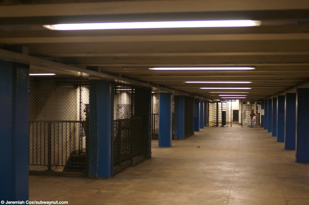
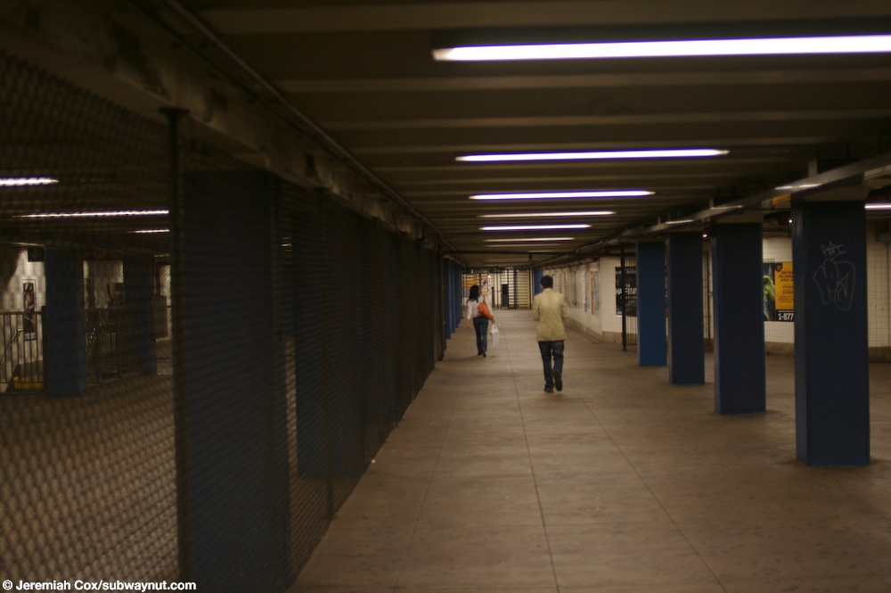
지역 선로와 급행 선로 사이에는 선로 벽이 있습니다.[30] 역에는 전체 길이의 메자닌이 있지만 요금 통제와 부스 구역이 메자닌의 중심에 있기 때문에 가장 동쪽 계단에서만 크로스오버가 가능합니다.[31][32]
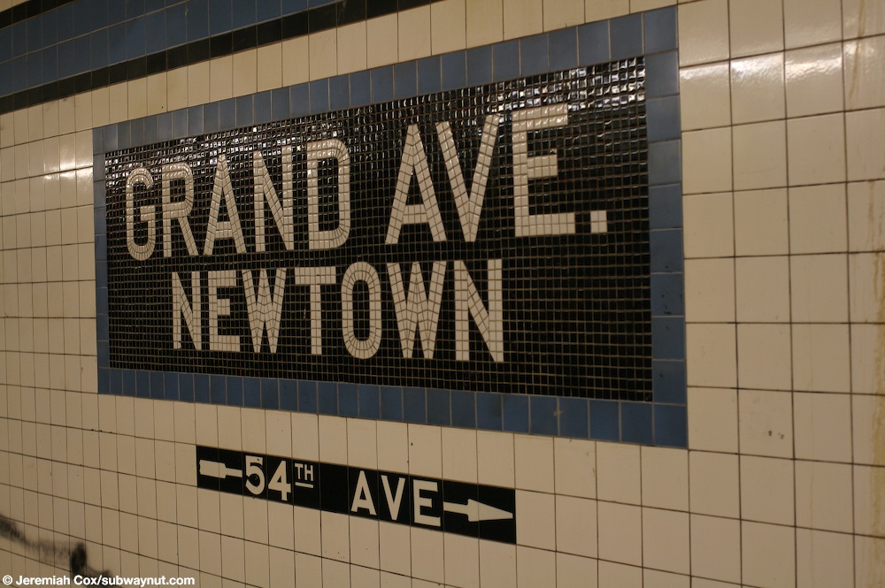
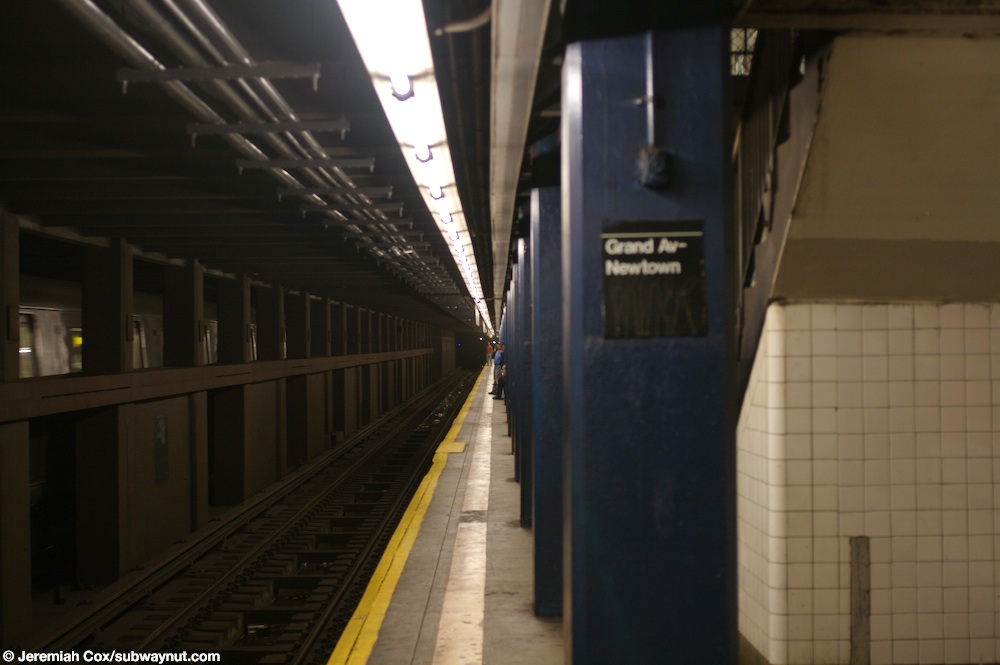
두 플랫폼 모두 검은색 테두리와 "GRAND AVE. – NEWTOWN"이라고 적힌 모자이크 명판이 검은색 바탕에 흰색 산세리프 글자로 두 줄로 갈라진 세룰레안 블루 색상의 타일 밴드가 있습니다.[33] 타일 밴드는 IND 전체에서 사용되는 색상 코드 타일 시스템의 일부였습니다.[34] 타일 색상은 로어 맨하탄을 떠나는 여행자들을 위해 항해를 용이하게 하기 위해 고안되었습니다. 따라서, 그랜드 애비뉴 역에서 사용되는 파란색 타일은 서쪽의 다음 급행역인 잭슨 하이츠-루즈벨트 애비뉴에서도 사용되며, 동쪽의 다음 급행역인 포레스트 힐스-71번가에서도 다른 타일 색상이 사용됩니다. Roosevelt Avenue와 71번가 사이의 다른 지역 역에서도 마찬가지로 파란색 타일이 사용됩니다.[35][36] 검은색에 흰색 글씨로 "GRAND"라고 적힌 작은 타일 캡션이 트림 라인 아래로 실행되며, 일부 이름 태블릿 아래에는 동일한 스타일의 방향 표시가 있습니다.[37][30]
파란색으로 칠해진 콘크리트 피복 기둥이 양쪽 승강장을 따라 일정한 간격으로 달리고, 흰색 문자로 표준 검은색 명판이 있는 기둥이 번갈아 나타납니다.[37][30] 이 교각은 15피트(4.6m) 간격으로 위치하며 플랫폼 위에 거더를 지지합니다. 지붕 거더는 또한 각 플랫폼에 인접한 벽의 기둥에 연결됩니다.[38]: 3
터널은 유틸리티 파이프와 전선이 들어 있는 "U"자 모양의 수조로 덮여 있습니다. 이 수조의 외벽은 기둥으로 구성되어 있으며, 그 사이에 콘크리트가 채워져 있습니다. 터널 벽과 플랫폼 벽 사이에는 1인치(25mm) 간격이 있으며, 4인치(100mm) 두께의 벽돌이 타일 마감으로 덮여 있습니다. 트랙 사이의 기둥도 5피트(1.5m) 간격으로 간격을 두고 있으며, 충전재는 없습니다.[38]: 3
출구
각 면에는 두 세트의 거리 계단이 있습니다. 저스티스 애비뉴와 브로드웨이 서쪽 끝에는 브로드웨이 양쪽으로 계단이 있는 풀타임 출입구가 있습니다. 또한 54번가에 있는 퀸즈 대로 남쪽 코너(뉴타운 제1장로교회 밖에 있는 남동쪽 코너 계단)로 가는 출구와 54번가에 있는 퀸즈 대로 북쪽으로 가는 또 다른 계단이 있습니다.[39]
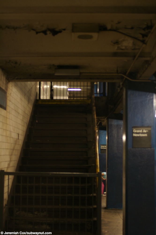
메자닌 양 끝에 있는 높은 입출국 개찰구를 통해 메자닌 중간까지 걸어 내려가지 않아도 요금 통제에서 벗어날 수 있습니다. 이 위치에는 두 플랫폼 간의 무료 교차가 있습니다. 원래는 양쪽 끝에 두 개의 요금 통제 구역이 있었는데, 맨하탄 행 쪽에 두 개의 닫힌 계단이 있는 것으로 보아 분명합니다.[40][41] 메자닌은 메자닌의 남쪽에서 닫힌 계단의 반대쪽으로 폭의 약 3분의 2로 좁아집니다. 메자닌이 좁아짐에 따라 맨해튼 방향과 같이 퀸스 방향의 계단은 허용되지 않았습니다.[42] 체인 링크 펜스는 요금 통제 내부와 외부 영역을 분리하는 데 사용됩니다. 맨하탄과 퀸스행 유료 지역은 메자닌의 중앙을 따라 이어지는 미결제 지역에 의해 이 지역으로 분리됩니다.[43] 총 4개의 계단이 있고 반대쪽에는 5개의 계단이 있습니다.[44]
참고문헌
- ^ "Borough of Queens, New York City". Government of New York City. Retrieved June 21, 2020.
- ^ "Glossary". Second Avenue Subway Supplemental Draft Environmental Impact Statement (SDEIS) (PDF). Vol. 1. Metropolitan Transportation Authority. March 4, 2003. pp. 1–2. Archived from the original (PDF) on February 26, 2021. Retrieved January 1, 2021.
- ^ "Annual Subway Ridership (2017–2022)". Metropolitan Transportation Authority. 2022. Retrieved November 8, 2023.
- ^ 참조:
- Duffus, R.L. (September 22, 1929). "Our Great Subway Network Spreads Wider; New Plans of Board of Transportation Involve the Building of More Than One Hundred Miles of Additional Rapid Transit Routes for New York". The New York Times. ISSN 0362-4331. Retrieved August 19, 2015.
- 1929년 8월 23일자 뉴욕시 엔지니어링 부서의 교통위원회, 추가 고속 수송선 및 차량 터널 제안
- ^ "Queens Lauded as Best Boro By Chamber Chief". The Brooklyn Daily Eagle. September 23, 1929. p. 40. Retrieved October 4, 2015.
- ^ "New Subway Routes in Hylan Program to Cost $186,046,000" (PDF). The New York Times. March 21, 1925. p. 1. ISSN 0362-4331. Retrieved March 27, 2020.
- ^ "$17,146,500 Voted For New Subways; Estimate Board Appropriates More Than $9,000,000 for Lines in Brooklyn. $6,490,000 For The Bronx Smaller Items for Incidental Work --Approves the Proposed Queens Boulevard Route". The New York Times. October 5, 1928. ISSN 0362-4331. Retrieved August 4, 2016.
- ^ Hirshon, Nicholas; Romano, Foreword by Ray (January 1, 2013). Forest Hills. Arcadia Publishing. ISBN 978-0-7385-9785-0.
- ^ "Two Subway Links Opened In Queens" (PDF). The New York Times. August 19, 1933. p. 13. ISSN 0362-4331. Retrieved December 11, 2016.
- ^ "Unfinished Sections of Subway Lines To Be Completed" (PDF). The New York Sun. December 13, 1933. p. 47. Retrieved July 30, 2016.
- ^ "Trains Testing Jamaica Link Of City Subway". The Brooklyn Daily Eagle. April 10, 1937. p. 3. Retrieved April 24, 2018.
- ^ "Test Trains Running In Queens Subway; Switch and Signal Equipment of New Independent Line Is Being Checked". The New York Times. December 20, 1936. ISSN 0362-4331. Retrieved April 26, 2016.
- ^ a b Neufeld, Ernest (August 23, 1936). "Men Toil Under Earth to Build Subway" (PDF). Long Island Daily Press. p. 2 (Section 2). Retrieved August 12, 2016.
- ^ 참조:
- "500 More Quit Subway Work On Boulevard: General Strike Order Issued Today; 72 Walk Out in Jamaica" (PDF). Long Island Daily Press. April 2, 1935. p. 2. Retrieved July 30, 2016.
- "Aldermen Probe Strike on Subway" (PDF). Long Island Daily Press. April 3, 1935. p. 4. Retrieved July 30, 2016.
- ^ Roger P. Roess; Gene Sansone (August 23, 2012). The Wheels That Drove New York: A History of the New York City Transit System. Springer Science & Business Media. pp. 416–417. ISBN 978-3-642-30484-2.
- ^ "City Subway Opens Queens Link Today; Extension Brings Kew Gardens Within 36 Minutes of 42d St. on Frequent Trains". The New York Times. December 31, 1936. ISSN 0362-4331. Retrieved April 26, 2016.
- ^ "Mayor Takes 2,000 for a Ride ln Queens Subway Extension: Heads Civic Leaders in 10-Car Train Over Route to Kew Gardens That Opens at 7 A. M. Today; Warns of 15-Cent Fare if Unity Plan Fails The Mayor Brings Rapid Transit to Kew Gardens". New York Herald Tribune. December 31, 1936. p. 34. ISSN 1941-0646. ProQuest 1222323973.
- ^ "Trains Testing Jamaica Link Of City Subway". The Brooklyn Daily Eagle. April 10, 1937. p. 3. Retrieved April 24, 2018.
- ^ "Jamaica Will Greet Subway" (PDF). The New York Sun. April 23, 1937. p. 8. Retrieved April 24, 2018.
- ^ a b Seyfried, Vincent F. (1995). Elmhurst : from town seat to mega-suburb. Vincent F. Seyfried.
- ^ a b Seyfried, Vincent F.; Asadorian, William (1991). Old Queens, N.Y., in Early Photographs. Courier Corporation. ISBN 978-0-486-26358-8.
- ^ "Old St. James Episcopal Church" (PDF). New York City Landmarks Preservation Commission. September 19, 2017. p. 10. Retrieved June 21, 2020.
- ^ "St. James Church" (PDF). National Register of Historic Places, National Park Service. November 12, 1999. p. 15. Retrieved June 21, 2020.
- ^ Dougherty, Peter (2006) [2002]. Tracks of the New York City Subway 2006 (3rd ed.). Dougherty. OCLC 49777633 – via Google Books.
- ^ "Late Night Subway Service" (PDF). Metropolitan Transportation Authority. March 23, 2023. Retrieved June 2, 2023.
- ^ "E Subway Timetable, Effective December 4, 2022". Metropolitan Transportation Authority. Retrieved August 26, 2023.
- ^ "F Subway Timetable, Effective August 28, 2023". Metropolitan Transportation Authority. Retrieved August 26, 2023.
- ^ "R Subway Timetable, Effective August 28, 2023". Metropolitan Transportation Authority. Retrieved August 26, 2023.
- ^ "Subway Map" (PDF). Metropolitan Transportation Authority. September 2021. Retrieved September 17, 2021.
- ^ a b c E., Bill (July 31, 2007). "Trackway Walls at Grand Avenue". www.nycsubway.org. Retrieved December 13, 2016.
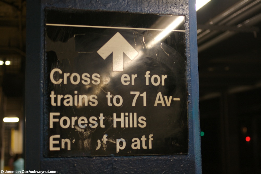
- ^ Cox, Jeremiah (June 5, 2008). "A sign indicating that the crossover to the other platform is at the easternmost end of the platform". subwaynut.com. Archived from the original on December 20, 2016. Retrieved December 13, 2016.
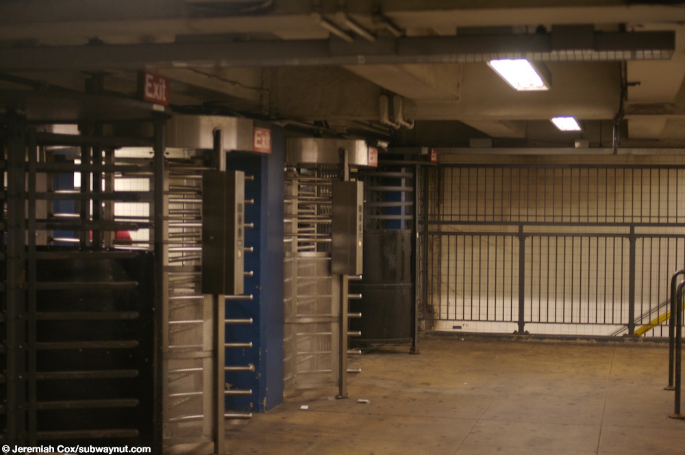
- ^ Cox, Jeremiah (June 5, 2008). "Two High Entrance Turnstiles, and Two High Exit Only turnstiles on the very narrow portion of the mezzanine that serves as an overpass between the two platforms". subwaynut.com. Retrieved December 13, 2016.
- ^ Cox, Jeremiah (June 5, 2008). "Another name tablet at Grand Ave-Newtown this one has a direction pointer for 54th Avenue underneath it". subwaynut.com. Retrieved December 13, 2016.
- ^ "Tile Colors a Guide in the New Subway; Decoration Scheme Changes at Each Express Stop to Tell Riders Where They Are". The New York Times. August 22, 1932. ISSN 0362-4331. Archived from the original on July 1, 2022. Retrieved July 1, 2022.
- ^ Carlson, Jen (February 18, 2016). "Map: These Color Tiles In The Subway System Used To Mean Something". Gothamist. Retrieved May 10, 2023.
- ^ Gleason, Will (February 18, 2016). "The hidden meaning behind the New York subway's colored tiles". Time Out New York. Retrieved May 10, 2023.
- ^ a b Cox, Jeremiah (June 5, 2008). "Looking down the Manhattan-bound platform at Grand Avenue-Newtown all the station columns look like boring columns of concrete with no forms in them or indentations giving them character". subwaynut.com. Retrieved December 13, 2016.
- ^ a b "New York MPS Elmhurst Avenue Subway Station (IND)". Records of the National Park Service, 1785 - 2006, Series: National Register of Historic Places and National Historic Landmarks Program Records, 2013 - 2017, Box: National Register of Historic Places and National Historic Landmarks Program Records: New York, ID: 05000672. National Archives.
- ^ "MTA Neighborhood Maps: Grand Av Newtown (M)(R)" (PDF). mta.info. Metropolitan Transportation Authority. 2018. Retrieved September 13, 2018.
- ^ Cox, Jeremiah (June 5, 2008). "hen the station opened their must have been a different staircase. There are two now fenced off staircases leading up from the Manhattan-bound platform up to the mezzanine when it is entirely outside of fare control. There is no place to put Queens-bound platform staircases because the mezzanine is only two thirds the width of the tracks and platforms here". subwaynut.com. Retrieved December 13, 2016.
- ^ Cox, Jeremiah (June 5, 2008). "Looking up a closed staircase from the Manhattan-bound platform that leads directly up to the mezzanine to a portion of it that is now outside of fare control". subwaynut.com. Retrieved December 13, 2016.
- ^ Cox, Jeremiah (June 5, 2008). "The mezzanine gets narrow, and the two separate sections of the mezzanine for trains in each direction ends making the entire 2/3 full width mezzanine outside of fare control". subwaynut.com. Retrieved December 13, 2016.
- ^ Cox, Jeremiah (June 5, 2008). "Looking down the mezzanine outside of fare control with the ugly black chain link fences visible on both sides segregating the area from within fare control". subwaynut.com. Retrieved December 13, 2016.
- ^ "R Train". January 13, 2015. Archived from the original on January 13, 2015. Retrieved July 12, 2016.
{{cite web}}: CS1 maint: bot: 원본 URL 상태 알 수 없음(링크)
외부 링크
- nycsubway.org – IND Queens Boulevard Line: Grand Avenue/Newtown
- 지하철 너트 – 그랜드 애비뉴 – 뉴타운
- Grand Avenue — Google Maps Street View에서 Broadway 입구
- Google 지도 스트리트 뷰에서 54번가 입구
- Google Maps Street View의 플랫폼
- 구글 지도 스트리트 뷰의 메자닌
| 퀸즈 블브드. 선 |
|
|---|---|
