빌라폰드 라
Bilafond La| 빌라폰드 라 | |
|---|---|
| 표고 | 5,450m(17,881ft) |
| 위치 | 라다크 (인도 지배, 파키스탄 분쟁)[1][2] |
| 범위 | 카라코람 동부 산맥 |
| 좌표 | 35°23˚N 76°57°E/35.383°N 76.950°E좌표: 35°23′N 76°57′E / 35.383°N 76.950°E/ |
 | |

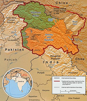
Indo-Pak mutually-agreed undisputed "International Border" (IB) in the black line, Indo-Pak "Line of Control" (LoC) in black dotted line in the north and west, Indo-Sino "Line of Actual" (LAC) in black dotted line in the east, Indo-Pak line across Siachen in north is "Actual Ground Position Line" (AGPL).녹색으로 표시된 지역은 파키스탄이 통제하는 두 지역이다: 북쪽의 길깃-발티스탄과 남쪽의 아자드 카슈미르.주황색으로 표시된 지역은 인도령 잠무와 카슈미르, 라다크 지역이며, 동쪽으로 대각선으로 연결된 지역은 악사이친으로 알려진 중국령 지역이다.북쪽의 "파키스탄이 인도가 주장하는 중국에 양도하는 기관"은 샥스감(트랜스 카라코람 트랙스)이다.

United Nations map of Siachen Glacier showing "Point NJ980420" (Point NJ9842) as starting point of "Actual Ground Position Line" (AGPL), Goma military camp of Pakistan, Nubra River valley and Siachen glaciers held by India; Bilafond La and Sia La north of NJ9842 are also held by India.마셔브룸 산맥, 발토로 빙하, 발토로 빙하, 발토로 무즈타그, K2는 파키스탄이 보유하고 있다.
Bilafond La (meaning "Pass of the Butterflies" in Balti language, also known as the Saltoro Pass, is a mountain pass situated on Saltoro Ridge, sitting immediately west of the vast Siachen Glacier, some 40 km (25 mi) directly north of map point NJ 980420 which defined the end of the 1972 Line of Control between Pakistan and India as part of the Sim협정.빌라폰드 라는 인도 아대륙과 중국을 잇는 고대 실크로드에 있다.[3]
빌라폰드 라는 1984년 인도와 파키스탄의 시아첸 분쟁에서 군사행동이 시작되었을 때 두드러진 특징이었다.인도군은 1984년 북쪽으로는 시아 라, 남쪽으로는 1987년 경 라와 함께 고갯길을 점령했다.[2]인도는 현재 빌라폰드 라에 요새화된 군사기지를 유지하고 있다.[4]
지정학적 문제
빌라폰드 고개는 시아 라와 경 라뿐만 아니라 1984년 시아첸 분쟁의 일부인 메그도트 작전이 시작되면서부터 군사 활동이 전개된 장면으로, 그 자체가 더 큰 카슈미르 분쟁의 일부가 되었다.[5]시아첸 빙하의 서쪽과 현재의 인도와 파키스탄 사이의 실제 지상 위치선 부근의 전략적 위치 때문에 인도군은 그들의 위치를 방어하기 위해 주둔하고 있다.[6][7]
참고 항목
- AGPL(실제 지상 위치 선) 근처
- 국경
- 갈등들
- 운영
- 인도 메그도트 작전
- 인도별 라지브 작전
- 인도, 세이프드 사가르 작전
- 기타 관련 항목
- 인도 군대의 상과 훈장
- 바나 싱(Bana Singh), 그 후 퀘이드 포스트(Quaid Post)가 바나탑(Bana Top)으로 개명되었다.
- 다프다르, 트란스 카라코람 트랙의 최서단 마을
- 인도-중국 국경 도로
- 인도의 극한 목록
- 중-파키스탄 간 카라코람 철도 중국 이양 협정
메모들
- ^ Baghel, Ravi; Nusser, Marcus (17 June 2015). Political Geography Vol. 48 (ed.). "Securing the heights; The vertical dimension of the Siachen conflict between India and Pakistan in the Eastern Karakoram". Political Geography. Elsevier. 48: 31–32. doi:10.1016/j.polgeo.2015.05.001.
- ^ a b Wirsing, Robert (15 November 1991). Pakistan's security under Zia, 1977-1988: the policy imperatives of a peripheral Asian state. Palgrave Macmillan, 1991. ISBN 978-0-312-06067-1.
- ^ "The Tribune, Chandigarh, India - Opinions". Tribuneindia.com. Retrieved 11 August 2017.
- ^ Child, Greg (1998). Thin air: encounters in the Himalayas. The Mountaineers Books, 1998. ISBN 978-0-89886-588-2.
- ^ Barua, Pradeep P. (30 June 2005). The State at War in South Asia (Studies in War, Society, and the Military). University of Nebraska Press. pp. 253–255. ISBN 978-0-8032-1344-9. Retrieved 6 August 2009.
- ^ . 6월 14일 2012년"BHARAT RAKSHAK MONITOR-볼륨 6(1)July-August 2003년"을 참조하십시오.146월 2012년에 원래에서 Archived.118월 2017년. 그 갈등의 지리학의 그것의 초창기를 포함한 아마도 가장 상세하게 논술, 설명하며, 아래로 Retrieved Bilafond의 컨트롤의 현재 상태,now-corrected error-plagued 오래 된 요약 이전에 게시의oft-copied 재결에 반대되는"3.". http://www.globalsecurity.org/military/world/war/siachen.htm
- ^ 자세한 현재 지도는 http://www.hinduonnet.com/fline/fl2304/stories/20060310001704400.htm을 참조하십시오.
참조
- Close C; Burrard S; Younghusband F; et al. (1930). "Nomenclature in the Karakoram: Discussion". The Geographical Journal. The Geographical Journal, Vol. 76, No. 2. 76 (2): 148–158. doi:10.2307/1783980. JSTOR 1783980.
- "A Slow Thaw". Time. 7 November 2005. Archived from the original on 11 September 2005. Retrieved 26 April 2010.


