라낙 라
Lanak La| 라낙 라 | |
|---|---|
| ལ་ནག་ལ | |
 Lanak의 위치 | |
| 표고 | 면적 m(17,933 ft) |
| 통과자 | 주립 도로 S519 |
| 위치 | 티베트, 중국, 인도 |
| 좌표 | 34°23′38″N 79°32′21″E / 34.3938°N 79.5391°ECoordinates:34°23′38″N 79°32′21″E/34.3938°N 79.5391°E/34.3938, 79.5391. |

| 라낙 라 | |||
|---|---|---|---|
| 중국어 | 拉那克山口 | ||
| |||
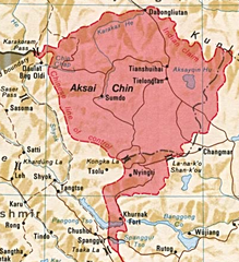
Lanak 라(티베트: ལ་ནག་ལ, 음역:은 논의되고 있는 아 커 사이친 지역이고, 중국은 티베트 자치구의 일부로 관리에 Lanag 라)또는 Lanak 패스(중국:拉那克山口, pinyin:Lā nà kè shānkǒu, 힌두어:लानक दर्रा)는 산길. 그것은 인도에 의해 국경 통하다를 주장하고 있습니다.
역사

라다크와 티베트 사이에 Lanak 라는 확립된 국경 지점 윌리엄 무어에서 1820년 이후에 여행객들로 확인했다.[2] 몇몇 여행자들은 19세기 후반과 20세기 초반에 인도와 티베트 간의 전통적인 경계 Lanak La.에서 책을 썼지 그들은 또한 국경 양쪽에 의해 받아들여졌다고 한다.[3][4][5][6][7][8][9][10]
그 창 Chenmo 계곡의 영역이 Lanak 패스까지 상당한 카슈미르 정부 기록이 있다. 매출액이 기록, 1908년 라다크 마을 보고서, 여러 조사 팀의 보고서 외에 잠무-카슈미르 게임 보존 법 1951년, 카슈미르 문서의 ChangChenmo 계곡에서 건설과 무역 항로, 나머지 집 그리고 창고의 유지와 관련 있다. 모든 그들이 Lanak 패스 라다크 안에 있는 골짜기 전체를 놓았다.[11]
중국


중국 지도들도 1951년까지 라낙 라를 경계로 인정했다.[12] 1956년 중화인민공화국은 콩카 고개가 경계로 표시된 최초의 자체 정의 지도로 보이는 것을 발표했다.
라나크 라 지역에는 1958년 6월 인도 순찰대가 창첸모 계곡을 따라 그곳에 올라가기까지 중국인이 한 명도 주둔하지 않았다.[13][14] 그곳에는 1956년까지 인디언 깃발이 꽂혀 있었다.[15][16]
이듬해 중국군이 창첸모 계곡에 잠입했다. 1959년 10월 인도 국경순찰대가 콩카고개 인근에 초소를 설치하려다 중국군의 매복 공격을 받아 일부는 숨지고 일부는 포로로 잡혔다.[17][18][18]
래리 워첼과 앨런 S와 같은 몇몇 서양 학자들은 칭칭은 콩카 고개가 티베트의 "전통적인" 경계였다는 중국의 주장을 지지하는 것으로 보인다.[19][20] 그러나 다른 학자들은 중국의 모순을 지적한다.[21][22]
역사 지도
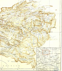
Cecil Rawling별 지도, Iset Map(1905)의 경계선 상에 Lanak La를 표시한다.
라낙 라를 포함한 지도 (스탠포드, 1917년)
라낙 라를 포함한 지도 (DMA, 1989년)
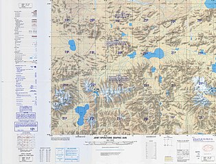
라낙 라를 포함한 지도 (라나코 산코우, CIA, 2013)
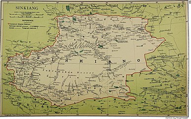
_(14776461552).jpg)
_p61_PLATE19._SINKIANG_(14597194848).jpg)


참고 항목
참조
- ^ Drew, Frederic (1875), The Jummoo and Kashmir Territories: A Geographical Account, E. Stanford – via archive.org
- ^ Richardson, H. E. (1962). A Short History of Tibet. E. P. Dutton. p. 225.[데드링크][ISBN 누락]
- ^ Wellby, M.S. (1898). Through Unknown Tibet. Lippincott. p. 78. ISBN 9788120610583.
- ^ Carey, A. D. (1887). "A Journey round Chinese Turkistan and along the Northern frontier of Tibet". Proceedings of the Royal Geographic Society. 9 (12): 731–752. doi:10.2307/1801130. JSTOR 1801130.
- ^ 바워, 해밀턴, 1894년 런던, 티벳을 가로지르는 여행의 일기
- ^ 롤링, C. G., 1903년 티베트 중부의 탐험 기록인 대 고원과 1904-1905년 가톡 원정대, 페이지 38, 런던, 1905년
- ^ Deasy, H. H. P. (August 1900). "Journeys in Central Asia". The Geographical Journal. 6 (2): 142. JSTOR 1774554.
- ^ Bruce, C. D. (June 1907). "A Journey across Asia from Leh to Peking". The Geographical Journal. 29 (6): 600. doi:10.2307/1776269. JSTOR 1776269.
- ^ "Report of the Officials of the Governments of India and the People's Republic of China on the Boundary Question - Part 2" (PDF). Ministry of External Affairs, India, 1961. Archived from the original (PDF) on 21 September 2013. Retrieved 30 August 2013.
- ^ Verma, Virendra Sahai (2006). "Sino-Indian Border Dispute At Aksai Chin - A Middle Path For Resolution" (PDF). Journal of Development Alternatives and Area Studies. 25 (3): 6–8. ISSN 1651-9728. Retrieved 30 August 2013.
- ^ 피셔, 로즈 & 허튼백, 히말라야 배틀그라운드(1963), 페이지 112
- ^ Karackattu, Joe Thomas (2020). "The Corrosive Compromise of the Sino-Indian Border Management Framework: From Doklam to Galwan". Asian Affairs. 51 (3): 590–604. doi:10.1080/03068374.2020.1804726. S2CID 222093756.
- ^ Hoffmann, India and the China Crisis (1990), p. 77: "This company was commanded by the most experienced Indian patrol leader in Ladakh, one Karam Singh, who (the previous June) had taken a patrol through Hot Spring, Kongka Pass, and then forty miles further to Lanak La. 그 당시 중국인의 존재는 전혀 보이지 않았다.."
- ^ Mullik, B. N. (1971), My Years with Nehru: The Chinese Betrayal, Allied Publishers, p. 627
- ^ Hudson, Geoffrey Francis (1963). Far Eastern Affairs, Volume 3. St. Martin's Press. p. 20.
- ^ "Notes, Memoranda and letters Exchanged and Agreements signed between The Governments of India and China - White Paper VIII" (PDF). Archived from the original (PDF) on 21 September 2013. Retrieved 30 August 2013.
- ^ 호프만, 인도 및 중국 위기(1990), p. 77 없음:)(도움말 "고개에서 서쪽으로 2마일 떨어진 장첸모 강둑에서 일어났다."(강변)
- ^ Jump up to: a b Maxwell, Neville (1970). India's China War. New York: Pantheon. p. 13.
- ^ Wortzel, Larry (2003). Burkitt, Laurie; Scobell, Andrew; Wortzel, Larry (eds.). The Lessons of History: The Chinese People's Liberation Army at 75 (PDF). Strategic Studies Institute, U.S. Army War College. p. 331. ISBN 9781428916517.
- ^ Whiting, Allen S. (1987). "The Sino-Soviet Split". In MacFarquhar, Roderick; Fairbank, John K. (eds.). The Cambridge History of China, Volume 14. Cambridge University Press. p. 512. ISBN 978-0-521-24336-0.
- ^ 피셔, 로즈 & 허튼백, 히말라야 배틀그라운드(1963년), 페이지 101: "라낙과 콩카 패스의 장첸모 계곡의 범위에 관한 갈등은 공산주의자들이 집권한 이후에도 계속 중국 지도술의 특징이 되었다... 중국의 공식 지도 제작자들이 국내외에서 보여준 융통성은 국경의 개념이 역사적으로 확고한 기반을 가지고 있다는 중국의 거듭된 주장을 조롱하는 것이다.
- ^ Van Eekelen, Willem Frederik (1967), Indian Foreign Policy and the Border Dispute with China, Springer, p. 164, ISBN 978-94-017-6555-8,
The Chinese could not quote a single document confirming that the Kongka Pass constituted the boundary.... The thorough approach of the Indian side generally contrasted with an inconsistent and almost careless presentation by the Chinese officials.
서지학
- Fisher, Margaret W.; Rose, Leo E.; Huttenback, Robert A. (1963), Himalayan Battleground: Sino-Indian Rivalry in Ladakh, Praeger – via archive.org