팡궁쵸
Pangong Tso| 팡궁쵸 | |
|---|---|
.jpg) 우주에서 본 판공쵸의 모습 | |
 팡궁쵸 판공호의 위치  팡궁쵸 팡궁쵸 (라다흐)  팡궁쵸 판공쵸 (티벳) | |
| 위치 | 레 구(인도, 라다크) 루토그 현 (중국 티벳 시) |
| 좌표 | 33°43′04.59″N 78°53′48.48″E/33.7179417°N 78.8968000°E좌표: 33°43′04.59″N 78°53′48.48″E / 33.7179417°N 78.8968000°E/ |
| 유형 | 소다호 어둑어둑한 호수(동쪽 분지)[1] 차가운 단극호(서분지)[citation needed] |
| 분지 국가 | 중국, 인도 |
| 최대 길이 | 134km(83mi) |
| 최대폭 | 5km(3.1mi) |
| 표면적 | 약 700km2 (1964 sq mi) |
| 최대 깊이 | 330피트(100m) |
| 지표면 표고 | 4,520미터(13,862피트)[2] |
| 얼어붙은 | 겨울철에 |
| 팡궁쵸 | |||||||||
|---|---|---|---|---|---|---|---|---|---|
| 한자이름 | |||||||||
| 중국어 번체 | 班公錯 | ||||||||
| 중국어 간체 | 班公错 | ||||||||
| |||||||||
| 대체 중국어 이름 | |||||||||
| 중국어 번체 | 班公湖 | ||||||||
| 중국어 간체 | 班公湖 | ||||||||
| |||||||||
| 티베트어 이름 | |||||||||
| 티베트어 | སྤང་གོང་མཚོ | ||||||||
| |||||||||
| 조모 은강라 링포 | |||||||||
|---|---|---|---|---|---|---|---|---|---|
| 한자이름 | |||||||||
| 중국어 번체 | 錯木昂拉仁波 | ||||||||
| 중국어 간체 | 錯木昂拉仁波 | ||||||||
| |||||||||
| 대체 중국어 이름 | |||||||||
| 중국어 간체 | 哥木克哥那喇令错 | ||||||||
| |||||||||
| 티베트어 이름 | |||||||||
| 티베트어 | མཚོ་མོ་ངང་ལྷ་རིང་པོ | ||||||||
| |||||||||
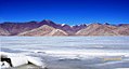
Pangong Tso or Pangong Lake (Tibetan: སྤང་གོང་མཚོ;[3] Chinese: 班公错; pinyin: Bān gōng cuò; Hindi: पैंगोंग झील) is an endorheic lake spanning eastern Ladakh and West Tibet situated at an elevation of 4,225 m (13,862 ft).길이는 134km(83mi)이며, 판공 쵸, 쵸 냐크, 럼 쵸(트윈 호수), 냐크 쵸라고 불리는 다섯 개의 서브레이크로 나뉜다.전체 호수 길이의 약 50%가 중국 티베트 내에 있고, 40%는 인도 라다크에 있으며, 나머지는 인도와 중국 사이의 실질적인 완충지대다.그 호수는 가장 넓은 지점에서 폭이 5km(3.1mi)이다.모두 합치면 604km에2 이른다.겨울 동안 그 호수는 염수임에도 불구하고 완전히 얼었다.인더스강 유역에서 작은 고갯마루로 분리되어 육지로 둘러싸인 분지가 있으나 선사시대에는 후자의 일부였던 것으로 추정된다.[4]
이름
역사적으로 이 호수는 좁은 수로를 통해 연결되는 5개의 해저로 이루어져 있는 것으로 여겨진다.판공쵸라는 이름은 라다크에 대부분 있는 최서단 호수에만 적용되었다.티베트 쪽의 주요 호수는 쵸냐크("중간호")라고 불린다.그 다음으로는 럼 쵸라고 불리는 두 개의 작은 호수가 있다.루독 근처의 마지막 호수는 다시 냐크 쵸라고 불린다.[5][6]호수군 전체가 티베트어로 쓰모 은강라 링포(Thomo Nganglha Ringpo, Tibetan: མཚོ)))ངང)))))))))))))))[3]로 불렸으며 지금도 자주 언급되고 있다.
판공쵸와 츠모 은강라 링포의 의미에 대해서는 해석이 분분하다.라다크 정부 웹사이트는 "팡공 쵸"가 "높은 초원 호수"[7]라는 뜻의 티베트어라고 표기하고 있지만, 수십 년 전 여행 책자들은 판공이 "하늘"을 의미한다고 말한다.[8][9]Tsomo Nganglha Ringpo는 다양하지만 유사한 의미를 의미하는 것으로 해석되는 티베트어로, 중국 언론 매체의 "길쭉하고 좁고 매혹적인 호수",[10] 초기 유럽 탐험가의 "여성의 좁고 매우 긴 호수",[11] 다른 현대 소식통의 "긴 목의 백조 호수" 등이 있다.[12][13]
식물과 동물
호수 동부는 총 용존 고형분의 함량이 0.68g/L로 신선하고, 호수 서부는 염분이 11.02g/L로 염도가 11.02g/L로 되어 있다.[14]그 호수의 고사리 같은 물은[15] 미세 채소가 매우 낮다.가이드들은 호수의 인도 쪽에는 일부 작은 갑각류 외에는 물고기나 다른 수생물이 없다고 보고한다.반면에 방문객들은 호수 표면 위와 위에서 수많은 오리와 갈매기를 본다.호수 주변 습지에서 자라는 스크럽과 여러해살이풀의 종류도 있다.
이 호수는 많은 철새들을 포함한 다양한 새들의 중요한 번식지 역할을 한다.여름 동안, 바헤드 거위와 브라미니 오리는 이곳에서 흔히 볼 수 있다.[16]호수 주변 지역은 키앙과 마못을 포함한 많은 종류의 야생동물들을 지원하고 있다.호수에는 대량의 물고기가 서식하고 있는데, 특히 '치즈모피고시스 스톨츠카이[17]'와 '라코마 라비아타'가 서식하고 있다.[18]라딕스속 민물달팽이도 호수에 서식한다.[19]
이전 판공초에는 인더스 강의 지류인 시석강으로 나가는 출구가 있었으나 자연 댐으로 인해 폐쇄되었다.인도 쪽에서 두 개의 하천이 호수를 먹여 가장자리에 습지와 습지를 형성하고 있다.[20]현재 호수 위쪽의 가닥 선은 진흙과 적층 모래를 5m(16ft) 두께로 나타내고 있어 최근 지질학적으로 호수가 줄어들었음을 시사한다.[15]인도 쪽에서는 물고기가 관찰되지 않았지만, 남동쪽(체슐날라)에서 오는 하천에서는 3종(치조피고프시스 스토릭츠카에, 티베트 석조 미꾸라지, 트리오피사 그라실리스)이 보고되었다(Bhat 외, 2011).낮은 생물다양성은 높은 염도와 가혹한 환경 조건 때문이라고 보고되었다(Bhat et al., 2011).
버드 이슬렛은 난가리 관광객들에게 새를 관찰하기 위해 인기 있는 곳이다.[21]
기후
| 팡궁쯔오 기후 데이터 | |||||||||||||
|---|---|---|---|---|---|---|---|---|---|---|---|---|---|
| 월 | 얀 | 2월 | 3월 | 4월 | 5월 | 준 | 줄리 | 8월 | 9월 | 10월 | 11월 | 12월 | 연도 |
| 평균 높은 °C(°F) | −5.9 (21.4) | −3.7 (25.3) | 0.9 (33.6) | 6.9 (44.4) | 11.6 (52.9) | 17.4 (63.3) | 20.5 (68.9) | 19.7 (67.5) | 15.5 (59.9) | 7.9 (46.2) | 1.5 (34.7) | −3.3 (26.1) | 7.4 (45.4) |
| 일평균 °C(°F) | −13.3 (8.1) | −10.8 (12.6) | −6.0 (21.2) | −0.5 (31.1) | 3.8 (38.8) | 9.5 (49.1) | 13.1 (55.6) | 12.7 (54.9) | 7.8 (46.0) | −0.3 (31.5) | −6.8 (19.8) | −11.3 (11.7) | −0.2 (31.7) |
| 평균 낮은 °C(°F) | −20.6 (−5.1) | −17.9 (−0.2) | −12.8 (9.0) | −7.8 (18.0) | −3.9 (25.0) | 1.6 (34.9) | 5.8 (42.4) | 5.7 (42.3) | 0.2 (32.4) | −8.5 (16.7) | −15.1 (4.8) | −19.3 (−2.7) | −7.7 (18.1) |
| 평균 강수량 mm(인치) | 4 (0.2) | 2 (0.1) | 3 (0.1) | 3 (0.1) | 4 (0.2) | 2 (0.1) | 11 (0.4) | 15 (0.6) | 4 (0.2) | 2 (0.1) | 2 (0.1) | 3 (0.1) | 55 (2.3) |
| 출처: Climate-Data.org | |||||||||||||
관광 접근권
이너라인 허가는 중국-인도어선 실제관제선에 있기 때문에 호수를 방문하기 위해 요구된다.허가증은 레에 있는 관광청에서 소정의 수수료로 취득할 수 있다.안전상의 이유로, 인도는 보트타기를 허용하지 않는다.단체들은 공인된 안내서를 동반할 수 있다.[22][23]
중국국도 219호선이 판공초 동쪽 끝을 지나고 있다.이 호수는 루토그에서 12km, 시취안허에서 130km 떨어진 곳에서 주행하면 접근할 수 있다.관광객들은 호수에서 배를 빌릴 수 있지만, 새들의 번식지를 보호하기 위해 섬에 착륙하는 것은 허용되지 않는다.해안을 따라 여러 개의 식당이 있다.[24]
중-인도 국경 분쟁
판공소는 분쟁 지역에 있다.실제 통제선(LAC)은 호수를 통과한다.LAC에서 동쪽으로 약 20km 떨어진 호수의 한 구간은 중국이 통제하지만 인도가 영유권을 주장하고 있다.호수의 동쪽 끝은 티베트에 있다.19세기 중반 이후 판공소는 존슨 선의 남쪽 끝에 있었는데, 악사이 친 지역의 인도와 중국 사이의 분계 시도의 초기 시도였다.
후르나크 요새는 판공쵸의 중간쯤 되는 호수의 북쪽 둑에 있다.중국인들은 1958년부터 후르나크 요새 지역을 통제해왔다.[27]남쪽으로는 더 작은 스팽구르 쵸 호수가 있다.
1962년 10월 20일, 판공쵸는 중국-인도 전쟁 중 군사 행동을 보았고, 인민해방군(PLA)에서 성공했다.[28]그 지역은 LAC를 따라 민감한 경계 지점으로 남아 있다.[29][30]중국 측의 침입은 흔하다.[31]
2017년 8월 판공초 인근 인도와 중국군은 발차기, 주먹질, 바위던지기, 막대기와 막대기와 같은 임시무기 사용 등 난투극을 벌였다.[32][33][34]2019년 9월 11일, PLA군은 북부 둑에서 인도군과 대치했다.[35][36]2020년 5월 6일 호수 근처에서 인도군과 중국군 250여 명이 대치하면서 양측에서 사상자가 발생했다.[37][33][38][39]
2020년 8월 29~30일 인도군은 판공쵸 남쪽 둑의 많은 고지를 점령했다.언급된 높이로는 레장 라, 레친 라, 블랙 탑, 하난, 헬멧, 구릉 힐, 고르카 힐, 마가르 힐 등이 있다.[40]이 높이들 중 일부는 LAC의 회색 지대에 있고 중국 캠프가 내려다보인다.[41]인도는 더 큰 해제를 위한 지렛대로 이러한 위치에서 물러나는 것을 선택했다.[42]
중국은 호수를 가로지르는 다리를 건설하고 있다.[43][44]중국과 인도 양군은 모두 이 호수에 선박을 배치하고 있다.[45][46][47]
갤러리

겨울왕국, 판공초

투명수

2018년 7월

여름동안

오리


지도


참고 항목
참조
- 메모들
- 인용구
- ^ 왕, M, 후, J, 그리고 레이, 2014년.계절 호수 수온의 변화에 따른 티베트 호수의 분류.중국 과학 회보, 59(34): 4847-4855.
- ^ 도르트 외, 파국적 부분 배수 (2011), 페이지 111.
- ^ a b "Ngari prefecture". Geographical names of Tibet AR (China). Institute of the Estonian Language. 3 June 2018. Retrieved 9 January 2020.
- ^ "River basins with Major and medium dams & barrages location map in India, WRIS" (Adobe Flash Player version 10.0.0 or greater). Archived from the original on 4 March 2016.
- ^ Sven Anders Hedin (1907). Scientific Results of a Journey in Central Asia 1899-1902: Central and West Tibet. Lithographic institute of the General staff of the Swedish army. p. 521.
From Noh to Bal Rawling followed the same route that I did along the northern shore of the Tso-ngombo, which he calls the Tso Mo Gualari, dividing it into the sections: Tso Nyak, the twin lakes Rum Tso and Nyak Tso. He says that it consists of a string of five lakes 120 m. in length, the four most southern of which are fresh, and Pangong, the most northerly, salt. They are joined together by channels about 60 feet in width and 15 feet deep, the current running at nearly 1½ mile an hour.
- ^ Saward, M. H. (1878). Routes in Asia: Routes in the territories of the Maharaja of Jummoo and Kashmir, and adjacent countries. Office of the Superintendent of Government Printing. pp. 31–33.
Only the lower lake (the Pangong Tso proper) lies in Ladak, the middle (Tso Nyak) and upper lakes being in Rudok territory. ... The waters of the western end are much more salt than those of the eastern end near Ot. in the stream connecting the Pangong Tso with Nyak Tso the water becomes drinkable, and rich grass is found on the banks.
- ^ "Pangong Lake". Union Territory of Ladakh. 29 October 2019. Retrieved 9 January 2020.
Pangong Lake, one of the most famous lakes in Leh Ladakh, derives its name from the Tibetan word, "Pangong Tso", which means "high grassland lake".
- ^ Michelle Coxall; Paul Greenway (1 September 1996). Indian Himalaya: a Lonely Planet travel survival kit. Lonely Planet. ISBN 978-0-86442-413-6.
The salty Pangong Tso - Pangong means 'hollow' - is the highest lake in Ladakh at about 4300m, and is flanked by massive peaks over 6500m high.
- ^ Kirit Rindani (7 January 2016). Indian Himalaya: Story of a 100 Visits. Partridge Publishing India. p. 80. ISBN 978-1-4828-5886-0.
The word Pangong means 'extensive concavity' which probably explains its size.
- ^ "Pangong Tso Lake in Tibet". China Daily. 17 July 2012. Retrieved 9 January 2020.
Pangong Tso Lake is a trans-border lake extending from the Ali prefecture of China's Tibet autonomous region to India. About 155 kilometers in length, the geographic features of the lake are indicated in the name which in Tibetan means "long, narrow, enchanted lake".
- ^ Trotter, H. (1877). "Account of the Pundit's Journey in Great Tibet from Leh in Ladakh to Lhasa, and of His Return to India Via Assam". Journal of the Royal Geographical Society of London. 47: 86–136. doi:10.2307/1798740. ISSN 0266-6235. JSTOR 1798740.
the Pangong, but better known to the Tibetans as the Chomo Gna Laring Cho, which, being literally interpreted, means "Female narrow very long lake."
- ^ "Pangong Tso Lake in the Northern Tibet". Kangba TV. 6 March 2017.
Pangong Tso Lake, at an altitude of 4,200 meters, is also called Tsomo Nganglha Ringpo Lake, which means "a swan with a long neck" in Tibetan.
- ^ "Pangong Lake". Tibet Vista (Tibettravel.org). Archived from the original on 28 April 2015. Retrieved 9 January 2020.
In the Tibetan language, this lake is called "Cuomu Angla Renbo Tso", which means "Long-Necked Crane Lake".
- ^ "班公错" (in Chinese).
- ^ a b R. K. Pant; N. R. Phadtare; L. S. Chamyal; Navin Juyal (10 June 2005). "Quaternary deposits in Ladakh and Karakoram Himalaya: A treasure trove of the palaeoclimate records". Current Science. 88 (11). Retrieved 29 January 2019.
- ^ Khan, Asif (2016). "Ladakh: The Land Beyond". Buceros. 21 (3): 6–15.
- ^ "Schizopygopsis stoliczkae". China Animal Scientific Database. Archived from the original on 5 March 2016. Retrieved 22 September 2018.
- ^ "Racoma labiata". China Animal Scientific Database. Archived from the original on 5 March 2016. Retrieved 22 September 2018.
- ^ 오임브, 파름 빅토르 폰, 크리스찬, 알브레히트, 리델, 프랭크, 두, 리나, 양, 융싱, 알드리지, 데이비드 C., 뷔히넥, 울리히, 장, 후카이, 윌케, 토마스(2011년)."티베트 고원의 청정수 생물지리학 및 임질학적 진화 - 고원-광범위 분포 미스트로포드 타손(Radix spp).PLOS One 6(10): e26307. PMID 22028853, doi:10.1371/journal.pone.0026307.
- ^ Biksham Gujja; Archana Chatterjee; Parikshit Gautam & Pankaj Chandan (August 2003). "Wetlands and Lakes at the Top of the World". Mountain Research and Development. Bern, Switzerland: International Mountain Society. 23 (3): 219–221. doi:10.1659/0276-4741(2003)023[0219:WALATT]2.0.CO;2. ISSN 1994-7151.
- ^ Dreams of Snow Land. Beijing: Foreign Languages Press. 2005. pp. 273-275. ISBN 7-119-03883-4 – via Internet Archive.
- ^ "A handy guide on how to visit the famous Pangong Lake in Ladakh". Times of India Travel. 3 December 2020. Retrieved 13 February 2022.
- ^ Javaid, Azaan (13 January 2021). "Pangong Tso opens for tourists amid Ladakh stand-off. This is how you can visit it". ThePrint. Retrieved 13 February 2022.
- ^ 黄慧英 (4 August 2018). "一措再措 邂逅高原湖泊的绝美" [Take measures to meet the beauty of plateau lakes] (in Chinese). tibet.cn. Retrieved 22 September 2018.
- ^ India, Ministry of External Affairs, ed. (1962), Report of the Officials of the Governments of India and the People's Republic of China on the Boundary Question, Government of India Press, Chinese Report, Part 1 (PDF) (Report). pp. 4–5.
이 전통적인 관습적인 경계선의 위치와 지형적 특징들은 현재 서부, 중부, 동부 세 분야로 다음과 같이 기술되어 있다.아네 고개에서 남쪽으로 경계선은 산등성이를 따라 이어져 봉우리 6,127(약 78° 46' E, 38° 50' N)[sic]을 지나 남쪽으로 판공호 북쪽 둑(약 78° 49' E, 33° 44' N)을 통과한다.그것은 이 호수를 가로질러 약 78° 43' E, 33° 40' N의 남쪽 둑에 도달한다.그리고 나서 통가다 강과 스팽구르 호로 흘러들어가는 물줄기를 따라 남향 방향으로 사점산에 도달할 때까지 간다. - ^ Lt Gen HS Panag (Retd) (4 June 2020). "India's Fingers have come under Chinese boots. Denial won't help us". The Print.
- ^ Sali, M. L. (1998). India-China Border Dispute: A Case Study of the Eastern Sector. APH Publishing. p. 82. ISBN 978-81-7024-964-1.
- ^ Burkitt, Laurie; Scobell, Andrew; Wortzel, Larry M. (July 2003). The Lessons of History: The Chinese People's Liberation Army at 75. Strategic Studies Institute. pp. 340–341. ISBN 1-58487-126-1.
- ^ Pubby, Manu (7 October 2008). "Pangong Lake is border flashpoint between India and China". The Indian Express. Retrieved 24 June 2009.
- ^ Shahin, Sultan (1 August 2003). "Vajpayee claps with one hand on border dispute". Asia Times. Archived from the original on 1 August 2003. Retrieved 24 June 2009.
{{cite web}}: CS1 maint : 부적합한 URL(링크) - ^ Holslag, Jonathan (2008). "China, India and the Military Security Dilemma, Vol 3(5)" (PDF). BICCS Background Papers. Brussels Institute of Contemporary China Studies (BICCS). Archived from the original (PDF) on 6 June 2011. Retrieved 24 June 2009.
- ^ 中共與印度邊境衝突!150士兵互毆10多人掛彩 [Another 150 soldiers in the Sino-Indian border conflict caused 12 injuries in a fight]. New Tang Dynasty Television (in Traditional Chinese). 11 May 2020. Retrieved 16 May 2020.
- ^ a b 費風 (11 May 2020). 中印邊境再爆衝突 150士兵毆鬥釀12傷 [Another 150 soldiers in the Sino-Indian border conflict caused 12 injuries in a fight]. Hong Kong Economic Times (in Traditional Chinese). Retrieved 16 May 2020.
消息指,第一起事件發生於5月5日至6日,在中印邊境的班公錯湖(Pangong Tso )地區,當時解放軍的「侵略性巡邏」(aggressive patrolling)被印度軍方阻攔。「結果發生了混亂,雙方都有一些士兵受傷。」{...}2017年8月,兩國軍隊曾於拉達克地區班公湖附近爆發衝突,當時雙方擲石攻擊對方,雙方均有人受傷,最終兩軍在半小時後退回各自據點。
- ^ Sushant Singh (20 May 2020). "India-China conflict in Ladakh: The importance of the Pangong Tso lake". The Indian Express. Retrieved 21 May 2020.
- ^ "Indian, Chinese Troops Face-off in Ladakh Ahead of Modi-Xi Summit, Army Says Tension De-escalated". CNN-News18. 12 September 2019. Retrieved 12 May 2020.
- ^ Chang Ya-Han 張雅涵, ed. (10 March 2020). 中國在西藏地區軍演頻繁 牽動中印未來危機應對 [China's military exercises in Tibet frequently affect China and India's future crisis response]. Radio Taiwan International (in Chinese (Taiwan)). Retrieved 16 May 2020.
- ^ Dinakar Peri (10 May 2020). "Indian, Chinese troops face off in Eastern Ladakh, Sikkim". The Hindu. Retrieved 13 May 2020.
- ^ "Chinese military bolsters troops in Aksai Chin region in Sino-India border: Report". The Economic Times. 19 May 2020. Retrieved 19 May 2020.
On May 5, around 250 Indian and Chinese army personnel clashed in Pangong Tso lake area in Eastern Ladakh.
- ^ Khalid, Saif (28 May 2020). "'All-out combat' feared as India, China engage in border standoff". Al Jazeera. Retrieved 5 February 2022.
- ^ Dutta, Amrita Nayak (3 September 2020). "Army now holding 30 dominating heights, earlier unoccupied, on southern bank of Pangong Tso". ThePrint. Retrieved 8 September 2020.
- ^ Sagar, Pradip R (2 September 2020). "India controls dominating heights in Chushul sector". The Week. Retrieved 8 September 2020.
- ^ Dhoundial, Shreya (17 February 2021). "India's Move to Occupy Kailash Range Became Turning Point in Disengagement Talks: Lt Gen YK Joshi". News18. Retrieved 7 February 2022.
- ^ Som, Vishnu (7 January 2022). Srinivasan, Chandrashekar (ed.). "Chinese Bridge Over Pangong Lake In Illegally Held Territory: Government". NDTV. Retrieved 8 January 2022.
{{cite web}}: CS1 maint : url-status (링크) - ^ Laskar, Rezaul H (4 February 2022). "India says China's bridge on Pangong Lake located in areas under 'illegal occupation'". Hindustan Times. Retrieved 7 February 2022.
- ^ Hooper, Craig (5 July 2020). "On Pangong Lake, Chinese And Indian Fleets Square Off At 14,000 Feet". Forbes. Retrieved 13 February 2022.
- ^ P, Rajat (13 June 2021). "Army gets special boats for Pangong Tso". The Times of India. Retrieved 13 February 2022.
- ^ Singh, Mayank (18 August 2021). "China raises firepower & mobility near Pangong Tso". The New Indian Express. Retrieved 13 February 2022.
참고 문헌 목록
- Cunningham, Alexander (1854), Ladak: Physical, Statistical, Historical, London: Wm. H. Allen and Co – via archive.org
- Dortch, Jason M.; Owen, Lewis A.; Caffee, Marc W.; Kamp, Ulrich (2011). "Catastrophic partial drainage of Pangong Tso, northern India and Tibet". Geomorphology. 125 (1): 109–121. Bibcode:2011Geomo.125..109D. doi:10.1016/j.geomorph.2010.08.017. ISSN 0169-555X.
- Godwin-Austen, H. H. (1867), "Notes on the Pangong Lake District of Ladakh, from a Journal made during a Survey in 1863", The Journal of the Royal Geographic Society of London, London: J. Murray, 37: 343–363, doi:10.2307/1798534, JSTOR 1798534
- Huntington, Ellsworth (1906), "Pangong: A Glacial Lake in the Tibetan Plateau", The Journal of Geology, University of Chicago, 14 (7): 599–617, Bibcode:1906JG.....14..599H, doi:10.1086/621337, S2CID 129014522
- Strachey, Henry (1854), Physical Geography of Western Tibet, London: William Clows and Sons – via archive.org
추가 읽기
| 위키미디어 커먼즈에는 판공쵸와 관련된 미디어가 있다. |
| 위키보이지에는 판공쵸의 상장이 있다. |
- Streule, M.J.; Phillips, R.J.; Searle, M.P.; Waters, D.J.; Horstwood, M.S.A. (2009). "Evolution and chronology of the Pangong Metamorphic Complex adjacent to the Karakoram Fault, Ladakh: constraints from thermobarometry, metamorphic modelling and U–Pb geochronology" (PDF). Journal of the Geological Society. 166 (5): 919–932. Bibcode:2009JGSoc.166..919S. doi:10.1144/0016-76492008-117. ISSN 0016-7649. S2CID 6633788.
- Srivastava P, Kumar A, Singh R, Deepak O, Kumar AM, Ray Y, Jayangondaperumal R, Phartiyal B, Chahal P, Sharma P, Ghosh R, Kumar N, Agnihotri R (July 2020). "Rapid lake level fall in Pangong Tso (lake) in Ladakh, NW Himalaya: a response of late Holocene aridity" (PDF). Current Science. 119 (2): 219–231.
- 중-인도 국경 방어 추술 지역(CIA, 1963)

