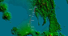
마리키나 계곡 단층 시스템
Marikina Valley Fault System| 마리키나 계곡 단층 시스템 | |
|---|---|
 Cavite, Carmona의 West Valley 단층을 따라 하층 및 상부 단층 | |
 마리키나 계곡 단층계 지도 상대적인 움직임과 변형을 보여주는 것 | |
| 어원 | 마리키나 |
| 이름: | 필리핀 화산 지진학 연구소. |
| 연도 정의됨 | 2010 |
| 좌표 | 14°38°N 동경 121°5°E/14.633°N 121.083°E좌표: 14°38′N 121°5′E / 14.633°N 121.083°E |
| 나라 | 필리핀 |
| 지역 | 중부 루손, 메트로 마닐라, 칼라바르존 |
| 도시들 | 서쪽:마리키나, 케손시, 파시그, 마카티, 타구이그, 문틴루파, 마리아노 알바레스, 카르모나, 실랑, 산페드로, 비냥, 산타 로사, 카부야오, 칼람바 동부: 로드리게스, 산마테오 |
| 특성. | |
| 세그먼트 | 웨스트 밸리 단층, 이스트 밸리 단층 |
| 길이 | 146km(91mi)[1] |
| 변위 | 10–12mm(0.39–0.47인치)/yr |
| 텍토닉스 | |
| 판 | 필리핀 해판 및 순다 판 |
| 상태 | 활동적인 |
| 지진 | 1658, 1771 |
| 유형 | 스트라이크-슬립 단층 |
| 움직임 | 덱스트랄 |
| 나이 | 젤라시안 |
| 오로젠성 | 루존 민도로팔라완 오로니 |
| 화산호/벨트 | 매콜로드 코리더 |
'밸리 단층 시스템(VFS)'으로도 알려진 마리키나 계곡 단층 시스템은 필리핀 루손에 있는 우파 단층[2] 시스템이다.북쪽의 불라칸 주 도냐 레퀴디오스 트리니다드에서 뻗어 나와 리잘 주와 메트로 마닐라의 퀘손 주, 마리키나 주, 파시그 주, 마카티 주, 타구이그 주, 문틴루파 주, 칸루방 주에서 끝나는 카비테 주와 라구나 주 등을 통과한다.[1]
결함 세그먼트
이 고장은 웨스트 밸리 단층(WVF)과 이스트 밸리 단층(EVF)으로 알려진 두 개의 주요 세그먼트를 포함한다.
- 웨스트 밸리 단층
웨스트 밸리 단층(WVF)으로 알려진 서쪽 구간은 메트로 마닐라를 거쳐 마리키나, 퀘존시, 파시그, 마카티, 타구이그, 문틴루파까지[1] 이어지는 밸리 단층 시스템의 2대 단층 구간 중 하나로, 주로 덱스트랄 스트라이크-슬립 동작으로 움직인다.[2]웨스트 밸리 폴트 구간은 길이 129.47km(80.45mi)의 도냐 레퀴티오스 트리니다드에서 칼람바까지 횡단한다.[1]
웨스트 단층은 진도 7 이상의 활성 단계에서 대규모 지진을 발생시킬 수 있다.[3]
- 이스트 밸리 단층
East Valley Fault(EVF)로 알려진 동부 세그먼트는 경사 덱스트랄 운동으로 이동한다.[2]로드리게스에서 리잘 지방의 산마테오까지 약 17.24km(10.71mi)에 이른다.[1]
위협

GPS, 실제 단층 기하학, 지진 초점 메커니즘을 활용하는 키네마틱 블록 모델을 바탕으로 마리키나 단층의 서쪽 부분은 거의 완전히 잠기는 것으로 확인되었으며, 이는 현재 10~12mm/yr의 비율로 탄성 스트레인을 축적하고 적재하고 있다는 것을 의미한다.[4]이 단층에는 메트로 마닐라와 주변 지방에 규모 6-7에서 최대 7.6의 대규모 지진이 발생할 위험이 있으며, 사망자 수는 최대 3만 5천[6][7] 명, 약 12만 명 이상이[6] 부상하고[7] 300만 명 이상이 대피해야 할 것으로 예상된다.[3]
80바랑게이 내 99개 민박과 구획은 2,964.10평방킬로미터(1,164.45평방mi)에 걸쳐 6,331개 동을 직접[8] 횡단하고 있으며, 대다수가 19개 학교가 포함된 주택이다.[1]
참조
- ^ a b c d e f Malicdem, Ervin (16 August 2017). "Barangays and Buildings Traversed by the Valley Fault System". Schadow1 Expeditions. Retrieved 7 September 2017.
There are about 6,331 structures that are directly above the Valley Fault System within a 10-meter proximity which would be in potential danger of destruction once the slip-fault moves. This sums up to an area of 2,964.10 square kilometers in danger of collapse.
- ^ a b c Rimando, Rolly E.; Knuepfer, Peter L.K. (2004). "Neotectonics of the Marikina Valley fault system (MVFS) and tectonic framework of structures in northern and central Luzon, Philippines". Tectonophysics. 415 (1–4): 17–38. doi:10.1016/j.tecto.2005.11.009.
- ^ a b "'Big One' Is Possible But Metro Is Unprepared". Quezon City, Philippines: Bulatlat. 14 August 2004. Retrieved 3 February 2010.
If a major earthquake were to hit Metro Manila today, the devastation would be so big even disaster response authorities cannot simply cope with it. And it even looks like disaster preparedness occupies a low priority among officials down to the municipal level.
- ^ Galgana, Gerald (2007). "Analysis of crustal deformation in Luzon, Philippines using geodetic observations and earthquake focal mechanisms". Tectonophysics. 432 (1–4): 63–87. Bibcode:2007Tectp.432...63G. doi:10.1016/j.tecto.2006.12.001.
- ^ Nelson, Alan R.; Personius, Stephen F.; Rimando, Rolly E.; Punongbayan, Raymundo S.; Tungol, Norman; Mirabueno, Hannah; Rasdas, Ariel (2000). "Multiple Large Earthquakes in the Past 1500 Years on a Fault in Metropolitan Manila, the Philippines". Bulletin of the Seismological Society of America. 90 (1): 84. Bibcode:2000BuSSA..90...73N. doi:10.1785/0119990002.
- ^ a b Ubac, Michael (20 June 2009). "UN to Metro Manila: Ready for Big One?". Inquirer.net. Philippine Daily Inquirer. Retrieved 30 January 2010.
Is Metro Manila prepared for the Big One?
- ^ a b "Big earthquake in Marikina Valley fault line?". Pinoymoneytalk.com. 2009-06-20. Retrieved 30 January 2010.
The United Nations is advising the Philippines to be ready for an upcoming big earthquake. A quake with a magnitude of 7 or higher on the Richter scale is sure to hit Metro Manila, they say, but the bigger question is when exactly this will happen.
- ^ Malicdem, Ervin (25 August 2017). "LIST: 99 Villages and Subdivisions Traversed by the Valley Fault System". Schadow1 Expeditions. Retrieved 7 September 2017.
외부 링크
- VFS: 마리키나 쿼드랑글 – 필리핀 화산 지진학 연구소
- 고해상도 West Valley Fault 맵 시작 - Rappler
- PIVOLCS FaultFinder - 이 웹 앱은 PIVOLCS, DOST, GSJ, AIST의 공동 협업 제품이다.그것은 조엘 C 박사에 의해 개발되었다.PIVOLCS의 연구개발 인력의 협업을 통한 GSJ의 반디바스.[1]


