페레아
Perea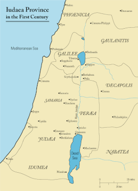

페레아 또는 페레아(그리스어: ερ ία πα, "그 너머의 나라")는 고대 요르단 강 횡단의 일부를 위해 고대 로마 시대에 주로 사용된 용어입니다.이 지역은 요르단 강 계곡의 동쪽, 곧 갈릴리 해와 사해를 연결하는 부분, 곧 요르단 강 하류의 삼분의 일 지점에서 사해 동쪽 해안의 삼분의 일 지점에 이르기까지 위치하고 있었습니다. 동쪽으로 그리 멀리 뻗어 있지는 않았습니다.헤로데 대왕과 그의 후손들, 그리고 나중에는 옛 유대를 포함한 로마 속주들의 일부였습니다.
역사
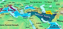
역사의 한 시점에서 페레아 또는 페레아로 알려진 영토는 요르단 횡단의 일부였으며, 헬레니즘 시대에 알렉산드로스 대왕, 나바타이아 아랍인, 유대인 하스모네아인의 상속자들의 국가들 사이에서 손을 바꾸었습니다.
페레아는 헤롯 대왕 왕국이 요르단 강 계곡 동쪽을 차지하고 있던 지역으로, 요르단 강 하류(갈릴리 해와 사해를 연결하는 부분)의 삼분의 일 지점에서 사해 동쪽 해안의 삼분의 일 지점까지 이르는 지역이었습니다.헤롯대왕의 나라는 네 명의 상속자들에게 물려졌고, 그 중에서 헤롯 안티파스는 페레아와 갈릴리를 모두 받았습니다.[1]그는 사해 북쪽에 있는 리비아스라는 도시를 리비아 드루실라로 태어난 아우구스투스의 아내 줄리아 아우구스타에게 바쳤습니다.[2]서기 39년, 페레아와 갈릴레이는 불리한 안티파스에서 칼리굴라에 의해 아그리파 1세로 옮겨졌습니다.[3]서기 44년에 그가 죽으면서, 아그리파의 합병된 영토는 다시 유대를 포함한 속주가 되었고, 처음으로 페레아가 되었습니다.[4]그[5] 때부터 페레아는 서쪽으로 이동하는 로마 속주들, 즉 유대와 후에 시리아 팔레스티나, 팔레스티나, 팔레스티나 프리마의 일부였습니다.요세푸스의 책에서 주로 증명된, 그 용어는 로마 시대 후기에 더 드물게 사용되었습니다.에우세비우스의 그리스어 지리학 작품인 오노마스티콘에 등장하지만, 제롬의 라틴어 번역에서는 트란스요르단이 사용됩니다.
페라이아의 가다라/가도라
페레아의 가다라(Gadora[6][7] of Perea) 또는 가도라(Al-Salt 근처의 Tell Jadur로 확인됨)는 페레아(Decapolis - 헬레니즘 도시의 가다라와 혼동하지 않도록 유대인 도시)의 주요 도시 또는 대도시였습니다.[8][9]기원전 63년 폼페이우스에 의해 주도된 로마의 유대 정복 이후, 시리아의 프로콘술인 아울루스 가비니우스는 옛 하스모네 왕국을 (산헤드린스로 더 잘 알려진 유대인 맥락에서) synedria라고 알려진 법률 및 종교 위원회의 다섯 구역으로 나누고 예루살렘, 예리코, 세포리스 (갈릴레이), 아마투스 (페레아), 가다라 (페레아에 있음)를 근거지로 합니다.알솔트에서, 데카폴리스에서, 움 카이스에서,[10][11][12][13][14] 또는 유대의 성서 게저에서, 요세푸스가 셈족의 이름인 가다라를 헬레니즘화한 형태로 언급했고, 뢰브 판에서[15] "가자라"로 편집했습니다.
대 플리니우스와 요세푸스
- c. 78 CE 연장자 플리니는 그의 작품에서, 네츄럴리스 히스토리아, 5권(15)은 다음과 같이 썼습니다.
[사마리아와 이두메아를 확장된 영토로 편입시킨 '대유대' 또는 '프로빈시아 이우다이아'.]시리아와 인접한 유대 지역은 갈릴리라고 불리고, 아라비아와 이집트 페라이아 옆에 있습니다.페라이아는 울퉁불퉁한 산으로 덮여 있고 요르단 강(원어 라틴어로 "Supra Idumaeam et Samariam Iudaea long lateque funditur")에 의해 유대의 다른 지역들과 분리되어 있습니다.Parseius Syriaeuncta Galilaea vocatur, Arabianevero et Aegypto proxima Peraea, asperis dispersa montibus et ateris Iudais Iordane discreta.")[16][17][18]
페레아... 갈릴레이보다 훨씬 큰 페레아는 일반적으로 사막이고 험준하며, 섬세한 과일이 자라기에는 너무 야생적입니다.그러나 어떤 지역에서는 토양이 황폐하고 다작하며, 다양한 종류의 나무들이 평원을 덮고 있지만, 올리브 나무, 포도나무, 야자나무가 주로 재배됩니다.또한 산천에 의해 충분히 관개됩니다. 그리고 (복날에 이런 것들이 실패한다면) 흐르는 샘에 의해 충분히 관개하기에 충분합니다.마개로스에서 펠라까지, 폭이 넓고, 필라델피아에서 요단 강까지, 우리가 이미 말했듯이, 그 북쪽 지역들은 펠라를 경계로, 서쪽 지역들은 강을 경계로 합니다.모압 땅은 남쪽 경계를 형성하고, 아라비아와 실보니티스는 필라델피아와 게라사와 함께 동쪽 경계를 형성합니다.[19][20]
타저자
프톨레마이오스는 그의 지리학에서 페레아라는 용어를 사용하지 않고, 오히려 "요르단 강 건너"라는 주변어를 사용합니다.그리고 그는 이 구역에 있는 코스마스와 리비아스와 갈레르호와 가사로스와 에피카에로스와 같은 '페레아' 성읍들을 열거했습니다.[21][22][23][24]
성경에서
히브리어 성경에 따르면, 트란스요르단 지역은 이스라엘 민족인 루벤, 갓, 그리고 므낫세의 반쪽 지파의 고향이었습니다.원문은 "페레아"라는 단어를 사용하지 않고, 오히려 히브리어 용어를 사용합니다. (히브리어: עבר הירדן, 로마자: ʿ 조차도 헤이야드, 불이 켜짐) '요르단 강 너머').몇몇 경우, 타나크족은 요르단강 동쪽의 모든 지역을 가리키기 위해 보통 트란스요르단의 북부만을 가리키는 길리어드라는 연관된 용어를 사용합니다.
신약성경 해설자들은 예수의 페레아 사역을 갈릴리에서 출발한 것(마 19:1; 마가 10:1)으로 시작하여 베다니에서 마리아가 성가신 것(마 26:6)으로 끝나거나 마가 10:32부터 예루살렘으로 향하는 여정으로 말합니다.
페레아(Perea)라는 이름의 다른 장소들
아르메니아에서 추방돼 이란 뉴줄파·이스파한 지역에 강제로 정착한 기독교 아르메니아인들은 세례자 요한의 안식처로서 페레아의 중요한 의미를 기려 주요 마을 이름을 '페레아'로 지었습니다.
하스모난 혼입
-
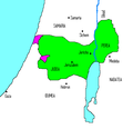
유다 마카베우스 치하 기원전 167-160년에 세워진 하스모네 왕국
-
시몬 타시 치하의 기원전 142-135년 하스모네 왕국
-
기원전 134-104년 존 히르카누스 치하 하스모네 왕국 (사마리아와 이두메아 정복 후)
-
아리스토불루스 1세 치하(갈릴레이 정복 후) 기원전 104-103년 하스모네 왕국
-
살로메 알렉산드라 치하 기원전 76-67년 하스모네 왕국
-
히르카누스 2세 치하 기원전 67-66년 하스모네 왕국 붕괴
헤로디언 혼입
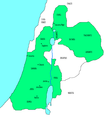
- 유대의 헤로데아 왕국
-
-
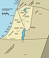
헤롯의 왕국은 그의 아들들 사이에 분열되어 있었습니다.
-
-
-
추후 편입
참고 항목
참고문헌
- ^ Josephus. BJ. 2.6.3..
- ^ Josephus. BJ. 2.9.1..
- ^ Josephus. BJ. 2.9.6.Josephus. BJ. 2.9.6.참고 1164
- ^ Josephus. BJ. 2.11.6.Josephus. BJ. 2.11.6.주석 1370, 1376
- ^ 페레아의 두 도시 아벨라와 이울리아스(리비아스)는 아그리파 2세(메이슨, S.)가 그가 서기 100년경에 사망할 때까지 지켜온 것을 제외합니다.
- ^ Rocca, Samuel (2015). Herod's Judaea: A Mediterranean State in the Classic World. Texts and Studies in Ancient Judaism / Texte Und Studien Zum Antiken Judentum, Volume 122 (reprint of 2008 Mohr Siebeck ed.). Wipf and Stock. p. 188. ISBN 9781498224543. ISSN 0721-8753. Retrieved 5 June 2020.
- ^ MacAdam, Henry Innes (2018). Geography, Urbanisation and Settlement Patterns in the Roman Near East. Routledge Revivals. Variorum Collected Studies, CS 735 (reprint of 2002 Ashgate ed.). Routledge. p. VI/16. ISBN 978-1-138-74056-3. Retrieved 5 June 2020.
- ^ Kitto, John (1851). The Cyclopædia of Biblical Literature. Newman & Ivison. p. 723.
GADARA was the chief city or metropolis of Peraea, lying in the district termed Gadaritis, some small distance from the southern extremity of the sea of Galilee, sixty stadia from Tiberias, to the south of the river Hieromax, and also of the Scheriat-al-Mandhur (Joseph. Antiq. xiii. 13. 3; Polyb. v. 71. 3; Joseph. De Bell. Jud. iv. 8. 3; Plin. Hist. Nat. v. 15). It was fortified, and stood on a hill of limestone. Its inhabitants were mostly heathens. Josephus says of it in conjunction with Gaza and Hippos 'they were Grecian cities' (Antiq. xvii. 11. 4).
- ^ Piotrkowski, Meron M. (2011). "When Did Alexander Yannai Capture Which Gadara?". Jewish Studies Quarterly. 18 (3): 266–276. doi:10.1628/094457011797248453. Retrieved 4 July 2016.
What may be concluded from these observations is that it was probably Gadara of the Peraea, not the more famous city [Gadara] of the Decapolis, that Yannai conquered early in his reign, as indicated in War 1.86 // Ant 13.356. This allows us to maintain an early dating of 102/101 BCE for the conquest of Gadara of the Peraea, alongside Amathus, while it also allows us to accept the inscription of 84 BCE as providing a terminus post quem for the conquest of the Gadara of the Decapolis.
- ^ Josephus. AJ. 14.5.4.페르세우스 프로젝트 AJ14.5.4, "그리고 그가 5개의 위원회 (συνέδρια)를 임명했을 때, 그는 나라를 같은 수의 부분으로 나누어 주었습니다.이들 회중은 예루살렘에 있고, 둘째 가다라에 있고, 셋째 아마두에 있고, 넷째 여리고에 있고, 다섯째 갈릴리에 있는 세포리스에 있습니다.'
- ^ "요셉푸스는 로마의 시리아 총독 가비니우스(기원전 57년)의 칙령과 관련하여 처음으로 συνέδριον를 사용합니다. 가비니우스는 헌법과 당시 팔레스타인의 기존 정부 형태를 폐지하고 나라를 다섯 속주로 나누고 각 속주의 머리에 산헤드린을 배치했습니다("개미.1455, § 4)." 유대인 백과사전을 통해서: 산헤드린:
- ^ Malamat, Abraham; Ben-Sasson, Haim Hillel (1976). A History of the Jewish People. Harvard University Press. p. 262. ISBN 978-0-674-39731-6.
Jewish Trans-Jordan reached from the hellenized city Pella (Fahal) in the north to Machaerus, east of the Dead Sea, in the south. Its western border was the Jordan River, and in the east it extended until the territory of the Greek cities Gerasa and Philadelphia. The settled area of the Peraea was divided into two parts. The smaller and doubtlessly less populated area lay north of the Jabbok. Its most important settlement was Amathus, a strong fortress from the Hellenistic period that had been conquered by Alexander Jannai and had become a Jewish town of some importance, the seat of a local Sanhedrin in the days of Gabinius and the capital of a toparchy. However, the majority of the Jews in Trans-Jordan lived south of the Jabbok, across the river from north-eastern Judea. The capital of this region was Gador (Es-Salt), which was considered the capital of the entire Peraea. South of Gador lay Abila (Abel-shittim) and Beth-haramata, and still farther to the south was the fortress Machaerus. Thus, geographically, the situation of Jewish Trans-Jordan was marked by two characteristics: its nearness to and common border with Judea and its location within the generally hostile neighborhood of the Greek cities to the east and north.
- ^ Ḳornfeld, Geʾalyahu; Mazar, Benjamin; Maier, Paul L. (1 January 1982). Josephus, the Jewish War: Newly Translated with Extensive Commentary and Archaeological Background Illustrations. Zondervan Publishing House. p. 42. ISBN 978-0-310-39210-1.
...Jewish TransJordan was represented by two councils: one in Gadara (Gedor), identified as E-tell in Peraea, near modern es-Salt in Jordan, and the other in Amathus (Hamthan), southeast of the Sea of Galilee.
- ^ Cohen, Getzel M. (3 September 2006). The Hellenistic Settlements in Syria, the Red Sea Basin, and North Africa. University of California Press. p. 284, n. 1. ISBN 978-0-520-93102-2.
The problem of indicating precise ancient boundaries in Transjordan is difficult and complex and varies according to the time period under discussion. After the creation of the Roman province of Arabia in 106 A.D. Gerasa and Philadelphia were included in it. Nonetheless, Ptolemy—who was writing in the second century A.D. but did not record places by Roman provinces—described them as being in (the local geographical unit of) Coele Syria (5.14.18). Furthermore, Philadelphia continued to describe itself on its coins and in inscriptions of the second and third centuries A.D. as being a city of Coele Syria; see above, Philadelphia, n. 9. As for the boundaries of the new province, the northern frontier extended to a little beyond the north of Bostra and east [words missing!]; the western border ran somewhat east of the Jordan River valley and the Dead Sea but west of the city of Madaba (see M. Sartre, Trois ét., 17-75; Bowersock, ZPE5, [1970] 37-39; id., JRS61 [1971] 236-42; and especially id.. Arabia, 90-109). Gadara in Peraea is identified today with es-Salt near Tell Jadur, a place that is near the western boundary of the province of Arabia. And this region could have been described by Stephanos as being located "between Coele Syria and Arabia."
- ^ Meyers, Eric M. (1999). Meyers, Eric M. (ed.). Sepphoris on the Eve of the Great Revolt. Papers of the 2nd International Conference on Galilee in Antiquity, 1997, Duke University. p. 113. ISBN 9781575060408. Retrieved 30 May 2020.
{{cite book}}:work=무시됨(도움말) - ^ "PLINY'S NATURAL HISTORY - Book V". masseiana.org. Archived from the original on 1 January 2017. Retrieved 1 August 2015.
- ^ Gaius Plinius Secundus; Sillig, Julius (1831). Naturalis historia. Teubner. p. 339.
- ^ "Pliny the Elder: Natural History, Book V". www.thelatinlibrary.com.
- ^ Flavius Josephus (1851). "BOOK III. CHAPTER 3. A Description of Galilee, Samaria, and Judea". The Jewish War of Flavius Josephus: A New Translation. Vol. 2. Houlston and Stoneman. p. 9.
- ^ 실보니염은 실보니염의 문자 오류입니다.헤스본. ()Emil Schürer D.D. M.A.; Aeterna Press. A History of the Jewish People in the Time of Jesus Christ: Two Divisions in Five Volumes. Aeterna Press. p. 1513.
- ^ 프톨레마이오스, 지리학 5권 15장 6절
- ^ Jones, A. H. M. (30 June 2004). "Appendix 2. Ptolemy". The Cities of the Eastern Roman Provinces, 2nd Edition. Wipf & Stock Publishers. p. 500. ISBN 978-1-59244-748-0.
Ptolemy's divisions of Palestine (v. xv) appear to follow popular lines. They are Galilee, Samaria, Judaea (with a subdivision 'across the Jordan'), and Idumaea. These divisions were also for the most part, as Josephus' survey of Palestine (Bell., III. iii. 1-5, §§ 35-57) shows, official. Josephus, however, does not recognize Idumaea, merging it in Iudaea, and definitely distinguishes Peraea from Judaea. Had Ptolemy derived his divisions from an official source, he would probably have followed this scheme, and in particular would have used the official term Peraea instead of the periphrasis 'across the Jordan'.
- ^ Smith, William (1873). A Dictionary of Greek and Roman Geography. J. Murray. p. 533.
[Ptolemy] describes the Peraea by a periphrasis as the eastern side of Jordan which may imply that the name [Peraea] was no longer in vogue.
- ^ Taylor, Joan E. (30 January 2015). The Essenes, the Scrolls, and the Dead Sea. Oxford University Press. p. 238. ISBN 978-0-19-870974-9.
Ptolemy's Geographica provided a great compendium of knowledge in terms of the placements of cities and lands in the ancient world, information that would form the basis of medieval cartography, resulting in a standard Ptolemaic map of Asia, including Palestine. The information about Judaea appears in Book 5, where pars Asphatitem lacum are mentioned as well as the main cities. In the region east of the Jordan, there are sites that are not all easy to determine: Cosmas, Libias, Callirhoe, Gazorus, Epicaeros (Ptolemy, Geogr. 5: 15: 6).
외부 링크
- 말론 H. 스미스에 의한 사료집의 페레아 출품작.
![]() 이 기사는 현재 퍼블릭 도메인에 있는 출판물의 텍스트를 통합합니다.
이 기사는 현재 퍼블릭 도메인에 있는 출판물의 텍스트를 통합합니다.


