훌룬호
Hulun Lake| 훌룬호 | |
|---|---|
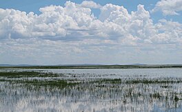
 갈대밭이 있는 호수의 전경. | |
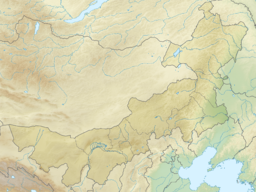
| 위치 | 내몽골(중국) |
| 좌표 | 48°58′23″N 117°26′08″E / 48.97306°N 117.43556°E좌표: 48°58′23″N 117°26′08″E / 48.97306°N 117.43556°E/ |
| 일차유입 | 오슈운골 케를렌 강 |
| 일차 유출 | 무트나야 프로토카(임시 아르군 강-아무르 분지 지류) |
| 유역 면적 | 33,469km2(12,922평방 미)[1] |
| 분지 국가 | 중국, 몽골 |
| 최대 길이 | 90km(56mi)[2] |
| 최대폭 | 27km(17mi)[2] |
| 표면적 | 2,339 km2 (903 sq mi) |
| 평균 깊이 | 5.7m(19ft)[1] |
| 지표면 표고 | 539m(1,768ft) |
| 공식명 | 달라이호수 국립자연보호구역, 내몽골 |
| 지정된 | 2002년 1월 11일 |
| 참조번호 | 1146[3] |
흐룬 호수(간체 중국어: 呼伦湖; 전통 중국어: 呼倫湖; 핀인: 후룬후; 몽골어: hö누르 хур, 점등. 발 호수) 또는 달라이 노르[4](몽골어: 달라이누르 даааааа,,,, 점등. 바다 호수)는 중국 북부 내몽골 지역에 있는 큰 호수다.
지리
이 호수는 중국 전역에서 5개의 가장 큰 담수호 중 하나로 약 2,339km를2 차지하고 있다.
이 호수는 주요 여객철도에 있는 만저우리에서 멀지 않다. 인근에 여러 마을이 있지만, 만저우리는 눈에 띄는 크기의 가장 가까운 도시다.
아무르 분지
강수량이 많은 해에는 보통 출구가 없는 내측호수가 북쪽 해안에 넘칠 수 있으며, 물은 약 30km(19mi) 후에 아르군강(에르구네)과 만난다. 그 아무르 유역은 케룰렌 River−Argun/Ergune River−Amur 강 시스템의 5,052킬로미터의 총 길이가 일본해로 정부 강 입에(3,139 mi)다.
이코노미
1995년 연간 어류 생산량은 약 7000톤, 새우 100톤, 진주 4kg, 가재 150만 마리였다.
흐룬 호수는 중국의 핵심 갈대 생산 지역 중 하나이다.[1]
레크리에이션
호수와 호수는 여름 동안 관광지다. 다른 계절에는 방문객이 거의 없다. 훌룬호와 그 습지는 중국의 생물권 보호구역이다.
참고 항목
참조
- ^ a b c LakeNet - Hulun Hu(Hulun Nur) Lake Profile
- ^ a b Google 어스를 사용하여 측정
- ^ "Dalai Lake National Nature Reserve, Inner Mongolia". Ramsar Sites Information Service. Retrieved 25 April 2018.
- ^ Berkey, Charles Peter; Morris, Frederick Kuhne; Central Asiatic Expeditions (1921-1930), Central Asiatic (1924). "Basin structures in Mongolia. Bulletin of the AMNH ; v. 51, article 5". Bulletin of the American Museum of Natural History. 51: 105.
The great basin of the Gobi contains many minor basins, which we are calling "talas," from a Mongol word for an open steppe-country (Fig.3). The following talas may be demonstrated: the Dalai Nor tala, now draining through the Argun river to the Amur; the Iren tala; the Gashuin Nor, or Edsin Gol tala; the Kisin or Shargin tala; the Khara and Dzapkhin, or Kirghiz Nor tala, in which are the cities of Kobdo and Uliassutai; the Tez, or Ubsa Nor tala. Each tala has its own local interior drainage and is bounded by inconspicuous warp divides or by mountain ranges, or both, separating it from neighboring areas of similar habit.
외부 링크
![]() 위키미디어 커먼스의 훌룬호수와 관련된 미디어
위키미디어 커먼스의 훌룬호수와 관련된 미디어


