프라타스 섬
Pratas Island| 분쟁 섬 네이티브 이름:東沙島 기타 이름:둥사 섬 둥사섬 | |
|---|---|
 1986년 1월, 우주에서 온 프라타 환초. | |
| 지리 | |
| 위치 | 남중국해 |
| 좌표 | 20°42°08°N 116°43°39°E/20.70222°N 116.72750°E좌표: 20°42°08°N 116°43 ″ 39 eE / 20.70222 °N 116.72750 °E / 、 |
| 전체 섬 | 1개[1]: 13 [2][3][4][5][6] |
| 지역 | 174ha(429.96에이커) (토지), 64ha(194.15에이커) (라군)[7][1]: 5 |
| 길이 | 2.8km(1.7마일) |
| 폭 | 0.865km(0.537mi) |
| 관리 대상자 | |
| 자치체 구 | 가오슝 치진[1]: 23 [8](치진) |
| 청구자 | |
| 지방 도도부현급 시 구 | 광둥성 산웨이(스와부) 청취[12][13] |
프라타스[11]: i [14]: 5 [15][16][17] 섬은 대만 [18][19]가오슝 시 치진 구에 있는 섬이다[1]: 13 [2][3][6].홍콩 [7][20]남동쪽 약 170해리(310km; 200마일) 지점에 있다.이곳은 64ha(160에이커)의 석호를 포함한 약 240ha(590에이커)의 면적을 가지고 있으며, 남중국해 제도 [21]중 가장 크다.이곳은 둥사 공항의 위치입니다.
프라타스 섬에는 프라타스 환초, 노스 베레커 뱅크, 사우스 베레커 [1]: 8, 9 [22][23][24]뱅크 등 세 가지 해저 특징이 있습니다.환초는 원형이며, 초승달 모양의 프라타스 섬이 서쪽을 차지하고 있다.프라타스 섬의 북서쪽(21°N 116°E/21°N 116°E) 바다 표면 아래에서[25] 북베레커 은행은 해수면 아래 11m(36ft)까지, 남베레커 은행은 해수면 [14]: 6 아래 58m(190ft)까지 솟아 있다.
둑의 [26]서쪽에는 수많은 유정이 있다.2007년, 동사 환초 국립공원이 섬에 설립되었습니다.중화인민공화국은 이 섬, 환초, 둑이 광둥성의 일부라고 주장하고 있다.
프라타스 제도


섬의 영어 이름은 포르투갈의 일라스 다스 프라타스 제도(Silver Plate Islands)에서 유래했다.이 섬은 16세기에 둥근 [citation needed][27]모양 때문에 환초에 붙여졌다.프라타스 환초는 프라타스 [28]환초라고도 불린다.
둥사[29][30][31][32][33] 섬 (둥사 타오) (중국어: 東沙島; 병음:동사도(東沙島, Wade-Giles: Tung-sha113 Tao, Pehh-oe-jī: Tang-soa-to)는 중국어로 Wade-Giles에서 유래한 섬 이름이고 동사섬[34](東沙島)은 핀인에서 유래한 이름이다.같은 한자 이름을 가진 더 작은 섬은 동중국해의 [35][36]마쓰 군도에 있는 대만에 있는 동인 향에 있습니다. 동중국해
섬, 환초, 둑을 포함한 지역은 프라타스[1]: 7 [2][37][38][39] 제도(중국어: 沙 islands島; pinyin:동사 쿤도, 페오에지: 탕소아 쿤토, '동사군도',[11]: 17 둥사군도[37][39][31][40][41][29], 둥사군도.[2][38]이런 이름에도 불구하고 프라타스 섬이 유일한 [1]: 13 [2][3][4][5]섬이다;[6] 섬들의 무리는 없다.
역사
동인디아만 백작 탤벗은 1800년 10월 22일 프라타스섬에서 선원 전원이 사망하면서 난파되었다.그 당시 그 섬은 영국 선원들에게 "페어스"라고 알려져 있었다.1851년, 영국의 스크류 슬루프 HMS 레이너드는 다른 난파선을 도우러 가던 중 프라타 환초 남동쪽 굴곡에서 난파했다. 선원들은 모두 [42]구조되었다.수십 년 후, HMS 레이너드호의 잔해 중 보일러와 기계 부품은 [43]환초에서 볼 수 있었다.
1859-1861년, 영국 식민지청과 홍콩 식민지 당국 사이에 환초 본섬에 등대를 건설하는 것에 대한 서신이 있었다.샤먼(아모이)의 영국인 사업가가 건설 제안을 했지만 비용이 너무 많이 들어 문제가 해결됐다.서신을 보면 아무도 환초가 알려진 관할구역의 일부라고 생각하지 않았음이 분명하기 때문에 건설이 합법적일 [44]수 있도록 협상이 요구되었을 수 있다.
이 이니셔티브의 결과 중 하나는 1858년 영국 해군 조사선 HMS 사라센이 최초로 환초 상세 조사를 완료했고, 그 결과 1858년 4월 영국 해군부가 [45]프라타스 암초 및 섬 계획 J. 리처드 등이 발표되었습니다.결과 차트에서는 3개의 위치가 제안되고 있습니다.프라타스 섬, 북동쪽 모서리 또는 HMS 레이너드가 좌초했던 남쪽 가장자리입니다.석호의 북동쪽 구석에는 "정크선의 정박장"이라고 적혀 있는데, 이는 어선이나 피난하는 다른 작은 선박들이 정기적으로 사용하는 것을 나타낸다.이 차트의 루브릭은 진입하는 선박에 사용할 수 있는 안전 드래프트가 15피트(4.6m)에 불과했기 때문에 비교적 작은 선박으로만 제한되었다고 지적했다.
1866년, 커스버트 콜링우드(자연학자)가 프라타스 섬을 방문했고 나중에 그 섬의 [46]묘사를 발표했다.
1908년부터 1909년까지 니시자와 요시지라는 일본인 사업가가 구아노 수집소를 설립했다.그는 다왕조스 가문을 파괴하고 무덤을 파헤쳐 중국 어민들의 유골을 바다에 쏟아부었으며 환초의 이름을 니시자와 [47][48]섬이라고 지었다.외교적 대립 끝에 중국 주권이 다시 세워졌고, 니시자와는 광둥성 정부로부터 보상을 받고 중국 어민 신사 [49]파괴에 대한 배상금을 지불한 후 철수했다.
1930년 12월 스쿠너선 헤드위그호(네덜란드)가 프라타스섬 앞바다 산호초에 좌초해 난파했다.[50][51]
1944년 5월 22일, 일본 함정 하시다테는 남중국해 프라타스섬 앞바다에서 21°08 117N 117°20 21E / 21.133°N 117.333/ 117.33에서 잠수함피쿠다에 의해 어뢰로 격침되었다.사상자는 알려지지 않았지만 그녀의 지휘관은 [52]살해되었다.
일본 해군 병력은 제2차 세계대전 중 프라타스 섬을 점령했다.일본 해군은 이 섬을 기상 관측소와 청취소로 사용했다.1945년 5월 29일 오전 10시 22분, 호주 특공대와 잠수함 USS 블루길호의 미 해군 병력으로 구성된 상륙대가 미국 국기를 게양하고 이 섬을 미국 영토로 선포하고 블루길 섬으로 명명했다.상륙부대는 전파탑, 기상대, 연료 및 탄약고, 건물 몇 채를 파괴했다.블루길이 [53][54][55]도착하기 전에 일본인들이 섬을 떠났기 때문에 그들은 아무런 저항을 받지 않았다.
프라타스 섬은 나중에 중화민국의 [56]광둥성에 복원되었다.1946년 9월 12일, 중화민국 해군이 프라타스 [1]: 10, 13, 15, 23 [18]섬을 점령하고 주둔하였다.
1949년 6월 6일, 중화민국은 프라타스 [18][19]섬을 포함한 하이난 특별 행정구를 설치했다.
1954년 가을, 중국의 원로 정치인인 장칭궈가 섬을 방문해 [18]시찰했다.
1960년 6월 9일 태풍 메리 때 홍콩 화물선 순리가 프라타스 암초에 부딪혀 난파했다.그녀의 55명의 승무원들은 구명정에 들어갔고 USS 요크타운에 의해 구조되었다.[57][58]
1965년 7월 18일 남중국해에서 항해하던 중 USS 프랭크 녹스는 프라타스 암초에 좌초되어 매우 어려운 구조 작업 [59][60]끝에 8월 24일에야 풀려났다.
1996년 4월 13일, 타이완 가오슝 지방 법원의 관할 구역은 퉁사 섬(프라타스 [29]섬)으로 확장되었다.
1999년 5월에는 가오슝 시장이 섬을 방문해 어로 서비스 스테이션에 [61]주소판을 달았다.2000년 12월 21일 천수이볜(陳水 visited) 대만 총통이 프랭크 셰([62][31]ung) 가오슝(高雄) 가오슝(高雄) 시장과 함께 섬을 방문했다.2005년 7월 28일 천수이볜(陳水 again) 국가주석은 다시 섬을 방문해 해경청 [31]제5해양순찰대를 발족시켰다.
2007년 1월 중국 정부는 [63]프라타 환초를 대만 최초의 해양국립공원인 둥사 환초 국립공원으로 지정했다.
2013년 1월 8일 프라타스 [64]섬에 중화우편 사무소가 설치되었다.
2020년 9월 중국 공군은 대만 본섬과 프라타스섬 사이의 방공식별구역(ADIZ)에 침입한 해상에서 공중훈련을 실시했다.그 비행기들은 [15]출발할 때까지 중국 군부에 의해 무선 경고를 받았다.
2020년 10월 15일, 유니 항공의 일반 민간 전세기가 타이완 본섬에서 프라타스 섬으로 가는 여행을 포기해야 했는데, 홍콩 항공 관제사가 항공기 기장에게 26,000피트(7,900m) 아래에서 "위험한 활동"이 일어나고 유니 항공기는 홍콩 항공편에 진입할 수 없다고 말했다. 정보 지역(FIR)조종사와 항공 관제사의 대화 녹취록은 중국 민간 [2][10][65][66][67][68]항공국에 의해 공개되었다.다음 날, 연덕파 국방부 장관은 "국제 [69][70]항공 질서를 어지럽히지 말라"고 중국에 요청했다.10월 20일, 리팅성(李-生) 중국 총참모부 차장이 프라타스 섬을 방문했다.그는 군 장병들의 생활시설을 시찰하고 [71]지시를 내렸다10월 26일, 같은 유니 에어 항공기가 대만 본섬과 프라타스 [72][73]섬을 왕복 비행했다.
2020년 10월 27일,[74] Y8 PRC 군용기가 대만 본섬과 프라타스 섬 사이의 ROC 영공에 21번째 진입했다.10월 28일 중국공산당 대만사무국 주펑롄(周lian連)은 푸젠(福建)과 광둥(廣東)에서 인민해방군 군사훈련에 비추어 중국으로부터 프라타스섬을 탈환할 계획이 있느냐는 질문을 받았다.펑은 그녀가 가상의 [75][76]질문에 대답할 필요가 없다고 대답했다.11월 2일, 8대의 중국 PLAAF 항공기가 프라타스 [77]섬 인근 해역 상공의 ROC 방공식별구역(ADIZ)을 침범했다.11월 3일 Y-8기가 대만 본섬과 프라타스섬 사이의 [78]ROC ADIZ에 진입했다.11월 4일, 옌더파 국방부 장관은 입법 청문회에서 2020년 1월부터 276대의 중국 군용기가 타이완 본섬과 프라타스 섬 사이의 영공에 진입했다고 밝혔다.옌은 중국 [65][79]남해에 자체 ADIZ를 설립하기 위한 중국의 계획과 관련이 있다.12월 6일, 중국 공군 Y-8기가 대만 본섬과 프라타스섬 사이의 대만 ADIZ에 진입했는데, 이는 12월 5일째인 12월 5일째에 중국 군용기가 대만의 ADIZ에 [80]진입한 것이다.
지리


프라타스 섬은 가오슝의 나머지 [61]지역으로부터 444km(276mi), 타이베이에서 남서쪽으로 850km(530마일), 홍콩에서[8] 남동쪽으로 320km(200마일), 남중국해 북부에 있는 광둥성[24] 산터우에서 남쪽으로 260km(160mi)에 위치하고 있다.국제 연구팀은 섬에서 채취한 11종의 해양 생물을 대상으로 종합적인 개체군 유전자 분석을 실시했다.그들은 해양 애벌레가 잠재적으로 북부 [81]남중국해의 많은 암초에 도달할 수 있기 때문에 둥사 환초는 남중국해 암초 사이의 유전적 연결을 촉진하는 중요한 지역 디딤돌이라고 결론지었다.따라서 대만 정부가 동사 환초 국립공원으로서 섬과 주변 암초를 보호하는 것은 지역 전체에 혜택을 줄 수 있다.
프라타스 섬은 길이 2.8km, 폭 0.865km로 해수면 위에 있는 이 군단의 유일한 특징이다.그 섬은 산호초와 암초 평원으로 이루어져 있다.덤불, 덩굴, 덤불이 섬의 일부를 덮고 있고 나머지는 백사장이다.프라타스 섬과 그 주변의 식물군과 동물군은 [citation needed]다음과 같습니다.
과학저널(1867년 4월)에는 중국해 프라타스 섬의 자연사라는 제목의 9쪽짜리 기사가 실려 있다.커스버트 콜링우드, HMS 서펜트에 탑승한 박물학자.그것은 측량선이 정박해 있는 동안 이틀 동안 관찰된 것, 특히 새들의 생물을 묘사하고 있다.콜링우드는 1866년 [46]4월 30일 섬을 탐험했다.
베레커 뱅크(21°N 116°E/21°N 116°E)는 프라타 [82]환초에서 북서쪽으로 74km(46m) 떨어져 있다.북부와 남부 베레커 은행은 물에 [25]잠겼다.노스베레커 뱅크(North[83] Verecker Bank)는 평균 수심이 60m(200ft)에서 90m(300ft)까지 해발 11m(36ft)까지 올라갑니다.깊이가 4.1m(13ft)인 우물 헤드는 노스 베레커 뱅크에서 30m(98ft) 떨어진 곳에 있습니다.2-3마일의 깊은 물이 노스 베레커 뱅크와 사우스 베레커 뱅크를 갈라놓습니다.사우스 베레커 은행(South[83] Verker Bank)은 해발 58미터(190피트)까지 솟아 있다.깊이가 100m(330ft)가 넘는 우물 헤드는 21°3의 Verecker Banks 북쪽 28m(45km) 지점에 있다.8µN 116°03ºE/21.633°N 116.050°E관련된 프로덕션 플랫폼과 SPM이 Lu Feng 터미널을 구성하고 터미널은 제한 구역으로 둘러싸여 있습니다.이 [14]: 6 지역은 석유 탐사가 진행되고 있다
또한 인근에는 [citation needed]세 개의 환초 중 일부가 아닌 일부 해산이 있다.
- 지안펑 해산(尖eng海山)
- 마오자해산(架家海山)
- 베이포해산(北北海山)
정치와 정부
이 섬은 우편번호가 817인 중화민국(대만)의 일부입니다.섬에 장기 거주자는 없지만 프라타는 치진( ci津)구 산하 가오슝(高雄)시가 관리하고 있다.이 섬에는 사람이 살지 않고 있지만 중국과 일본을 포함한 국가들은 이 섬을 자신들의 해외 영토라고 주장하고 있다.
군사의
프라타스 섬에는[update] 2020년 11월 현재 약 500명의 대만 해병이 주둔하고 있다.그 섬에는 지하 [84]벙커망이 있다.2020년 12월 2일 개정된 규정에 따르면 대만 본섬과 프라타스 섬 또는 타이핑 섬(이투아바) 사이에 통신이 두절될 경우 현지 최고위급 장교가 공격자에게 [85]반격을 결정할 수 있다.
양안 관계
중화인민공화국은 프라타스 제도를 [9][10][11]: 10 [12][13]광둥성 산웨이시 청취의 일부라고 주장하고 있다.
익명의 PLA 소식통에 따르면 중국이 2010년경 남중국해 방공식별구역 계획을 수립한 것도 프라타스섬 [86]영공을 포함하고 있다.PLA는 2020년 말 대만 AIDZ와 프라타스 섬의 남동쪽 구석에서 이 지역을 중국에 [79][87][88]의해 ADIZ의 일부로 선언할 수도 있다는 추측을 낳았다.
2020년 후반에는 중국군의 훈련과 섬 부근에서의 비행이 반복된 보고는 프라타 섬과 [89]대만 본섬 사이의 보급선을 차단하려는 시도로 해석되었다.
프라타스 섬 정착촌
영구 거주자가 없는 섬인 이곳은 어부, 군인, 연구자들이 많이 찾는다.DXCC와 아일랜드 온 더 에어 어워드 프로그램에 참가하는 아마추어 무선사업자들도 [90]가끔 방문한다.
랜드마크
오벨리스크는 [citation needed]1946년 이후에 세워졌다.
1954년 프라타스에 주둔한 중국 정부 요원들은 섬의 남쪽 바다에 [91]면한 곳에 비석을 세웠다.
다왕 사원은 '광강'과 '남중국 바다의 여신'인 마즈에게 바쳐졌다.관공상은 1948년 카누를 타고 프라타섬에 왔다고 한다[by whom?].프라타스 섬의 군인들은 1975년에 그녀를 숭배하기 위해 사원을 지었다.오늘날,[when?] 카누는 여전히 사원에 보관되어 있다.조스 스틱과 초는 군인들에 의해 기증되며, 동상 앞에 걸린 금색 간판이 있다.절 앞에는 군인들이 지은 '에버 그린' 정자가 있다.그곳은 [91]섬에서 가장 푸른 곳이다.
중화민국 [91]총무대신은 1989년 중화민국의 주권을 선언하기 위해 남중국해 방위성 석판을 세웠다.
1991년 7월 가오슝시 정부는 프라타섬이 가오슝시 [91]관할구역에 속한다는 상징으로 프라타섬 측정 비석을 세웠다.가오슝에 있는 이 섬은 치진구에 속해 있다.
중국 정부는 1991년 12월 프라타스 섬의 삼각 측량 지점으로 삼각 측량 벤치마크를 제정했다.삼각점석패의 밑면 양쪽에 글씨가 새겨져 있습니다.정면에는 '프라타 삼각점', 경도: 116o 43" 42.5601'E, 위도: 20o 42" 6.2415'N, 높이: 2.4875m라고 적혀 있다.대장 Lo Ben Li가 쓴 '남중국해를 지켜라'라는 글귀도 비석에 새겨져 있었다.국립 칭화대 웹페이지에는 "도상에 측량, 지도 그리기, 시설 건설 및 개발을 보다 편리하게 할 수 있을 뿐만 아니라 삼각 측량 지점의 설립도 주권의 [91]기본이다."라고 적혀 있다.
공공 건물

중앙광장 한쪽에 위치한 도서관은 장병들이 정신적 영양을 섭취할 수 있는 중심지이다.도서관에는 2천 권 이상의 [91]책이 있다.
군 우체국은 67호 사무실입니다.교통부는 1996년에 '남중국해 지도 우표'를 두 장의 우표 세트로 발행했다.5달러짜리 우표에는 프라타스섬의 국가석판에 '남중국해 방어'라는 글귀가, 17달러짜리 우표에는 '태평섬의 국가석판에 있는 '남중국해 방어'라는 글귀가 새겨져 있다.배경은 푸른 하늘과 바다를 가진 중국 남부 해안선, 대만, 하이난 섬이었다.남중국해를 [91]주제로 한 우표가 발행된 것은 이번이 처음이다.
1987년 군인과 민간인은 '프라타스 어민 서비스 스테이션'을 건설했다.이 역은 전통적인 중국식 안뜰집으로 지어졌으며, 남중국해의 어부들과 배들에게 편리한 서비스를 제공하여 어민들의 안전을 보장하고 ROC의 주권을 수호한다.제공되는 서비스에는 숙박, 의료 구조, 접대 및 보급이 포함됩니다.이 우주 정거장은 [91]또한 섬에 연구를 하러 오는 과학자들을 위한 숙소를 제공한다.
2012년 국립 쑨원 대학의 동사 환초 연구소는 생물학, 생물 화학, 해양학 [92]연구를 위해 설립되었다.
에너지
디젤 연료 발전기가 섬에 전력을 공급하기 위해 사용된다.2016년 3월, 해경청이 건설한 태양광 시스템이 가동되기 시작했다.이 시스템의 면적은 3102.6m이며 매년 [93]53,200kWh의 전기를 생산합니다.
교통.
둥사 섬 공항은 프라타스 섬의 북쪽 끝에 위치한 활주로와 동쪽 끝에 작은 공항 터미널이 있습니다.공항은 중국 군대가 사용하고 있다.섬의 남동쪽 끝에는 주요 판잣집과 부속 판잣집이 있다.급유 시설은 없습니다.
남동쪽 해안에 있는 두 개의 교각은 작은 수상선이 상륙할 수 있게 해 준다.
프라타스섬을 중심으로 반경 10nmi(19km)의 원(VHR7)은 항공사용 금지구역이다.VHR7의 'VH'는 '홍콩'을 나타내고 'R'은 '제한 구역'[32]을 나타냅니다.프라타 섬과 VHR7은 홍콩 비행 정보 지역(FIR)[2][10][94] 내에 위치해 있습니다.
갤러리

프라타스 섬 라군

공항.

프라타스 해변

프라타 환초 남단
(프라타스 섬이 멀리 보인다)


)_Dongsha_Atoll_National_Park,_WEY,_10.jpg)
「 」를 참조해 주세요.
레퍼런스
- ^ a b c d e f g h Lung Tsun-Ni 龍村倪 (1998). 東沙群島-東沙島紀事集錦 (in Chinese (Taiwan)). Taipei: 臺灣綜合研究院. ISBN 957-98189-0-8. Archived from the original on 30 January 2009. 페이지 13: "프라타스 섬" (번역: 프라타스 섬은 프라타스 제도의 유일한 섬)
- ^ a b c d e f g Danny Lee (17 October 2020). "Hong Kong blocks Taiwan from reaching disputed Pratas Islands, saying airspace around disputed territory is closed 'until further notice'". South China Morning Post. Archived from the original on 28 October 2020. Retrieved 1 November 2020.
The Pratas Islands, known as the Dongsha Islands in Chinese and located within Hong Kong airspace, comprise one island, two coral reefs and two banks.
- ^ a b c "Limits in the Seas - No. 127 Taiwan's Maritime Claims" (PDF). United States Department of State. November 15, 2005. Archived (PDF) from the original on 15 July 2020. Retrieved July 1, 2012.
The Pratas Reef lies 230 miles to the southwest of the southern tip of Taiwan.26 It consists of an island in the mouth of a semicircular shoal open to the west. The segments D1-D4 close the mouth by connecting the headlands of the shoal with the island.
- ^ a b Dong Manh Nguyen (December 2005). "Settlement of disputes under the 1982 United Nations Convention on the Law of the Sea The case of the South China Sea dispute" (PDF). p. 8. Archived (PDF) from the original on 10 July 2009.
- ^ a b 【海洋研究】東沙二十part1:擁有世界級珊瑚生態的神秘東沙島在哪裡?(我們的島 第933集 2017-12-04). Our Island (我們的島) (in Chinese (Taiwan)). Public Television Service. 11 December 2017. Event occurs at 8:20. Retrieved 1 November 2020 – via YouTube.
東沙島則是唯一突出水面的島嶼
- ^ a b c Dieter Heinzig (1976). Disputed Islands in the South China Sea (PDF). pp. 14, 19, 32, 56. ISBN 3-447-01804-6. Archived from the original (PDF) on 22 January 2017. 페이지 14: 엄밀히 말하면, 4개의 논란이 되고 있는 군도 중 1개만이 진정한 의미의 섬 집단으로 언급될 수 있다.파라셀 제도.프라타는 하나의 섬과 두 개의 모래로 이루어져 있습니다."
- ^ a b Pratas Islands 2012-08-06 Wayback Machine에서 아카이브(vm.nthu.edu.tw)
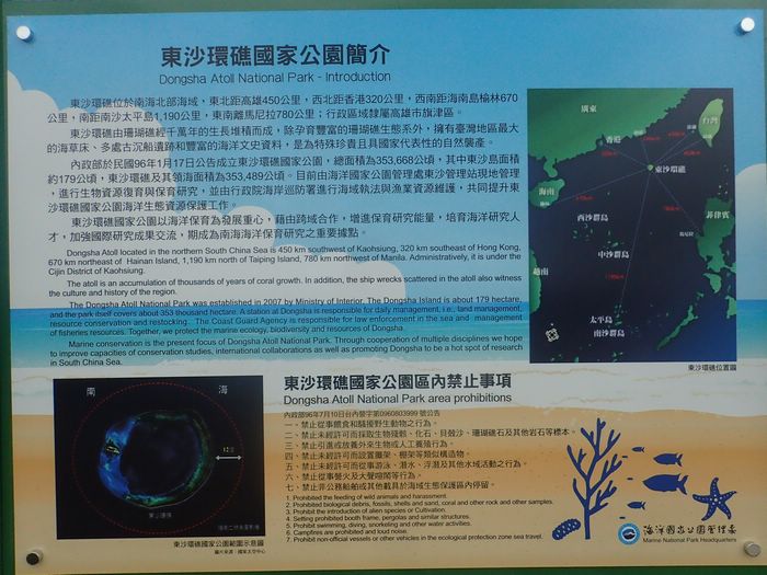
- ^ a b 東沙環礁國家公園簡 [Dongsha Atoll National Park - Introduction]. Marine National Park Headquarters (海洋國家公園管理處) (in Chinese (Taiwan) and English). Archived from the original on 1 October 2020.
東沙環礁位於南海北部海域,東北距高雄450公里,西北距香港320公里,西南距海南島榆林670公里,南距南沙太平島1,190公里,東南離馬尼拉780公里;行政區域隸屬高雄市旗津區。{...}Dongsha Atoll located in the northern South China Sea is 450 km southwest of Kaohsiung, 320 km southeast of Hong Kong, 670 km northeast of [Yulin on] Hainan Island, 1,190 km north of Taiping Island, [and] 780 km northwest of Manila. Administratively, it is under the Cijin District of Kaohsiung.
- ^ a b "Law on the Territorial Sea and the Contiguous Zone of 25 February 1992" (PDF). Archived (PDF) from the original on 18 July 2004 – via United Nations.
The PRC's territorial land includes the mainland and its offshore islands, Taiwan and the various affiliated islands including Diaoyu Island, Penghu Islands, Dongsha Islands, Xisha Islands, Nansha (Spratly) Islands and other islands that belong to the People's Republic of China
- ^ a b c d "Taiwan releases records to rebut HK's claim it abandoned its flight plan". Overseas Community Affairs Council. 17 October 2020. Archived from the original on 2 November 2020. Retrieved 2 November 2020.
The Dongsha Islands, administered by Taiwan but also claimed by China, are located about 310 kilometers southeast of Hong Kong and are within its Flight Information Region (FIR).
- ^ a b c d "SOUTH CHINA SEA: UP FOR GRABS" (PDF). Bureau of Intelligence and Research. 14 September 1971. Archived from the original (PDF) on 23 January 2017. 페이지 10: "프라타스 산호초 (둥사춘타오)" {...}중국은 이 암초가 유일한 중국이라고 주장하기 때문에 암초에 대한 권리를 주장합니다."
- ^ a b 汕尾市. 广东省民政厅网站 (in Simplified Chinese). May 2005. Archived from the original on 3 November 2020.
城区{...}(东沙群岛不是镇建制)
- ^ a b 广东省国土资源厅 (30 June 2018). 城区地图 (Map). Department of Natural Resources of Guangdong Province 广东省自然资源厅 (in Simplified Chinese). Archived from the original on 7 July 2020 – via Internet Archive.
东沙群岛{...}北卫滩{...}南卫滩{...}东沙岛{...}东沙礁
- ^ a b c South China Sea and the Gulf of Thailand (PDF). National Geospatial-Intelligence Agency. Sailing Directions (Enroute) (17 ed.). Springfield, Virginia. 2020. Archived (PDF) from the original on 2 November 2020.
- ^ a b Steven Stashwick (11 September 2020). "Chinese Jets Intrude Taiwan Air Defense Zone for Second Day". The Diplomat. Archived from the original on 11 September 2020.
- ^ "China to conduct major military drill simulating seizure of Taiwan-held island". Japan Times. 14 May 2020. Archived from the original on 14 May 2020. Retrieved 4 November 2020.
- ^ 미국 국립지리정보국(National Geospace-Intelligence Agency) GEOnet Names Server의 Pratas Island(승인 - N)
- ^ a b c d 東沙島地方志資源調查委託辦理計畫 成果報告 (PDF). Marine National Park Headquarters 海洋國家公園管理處 (in Chinese (Taiwan)). December 2008. p. 26. Archived (PDF) from the original on 9 July 2020. Retrieved 9 July 2020.
民國35年(1946年){...}9月,海軍負責接收東沙島,並設立東沙管理處;東沙氣象台由海軍負責管理。{...}民國43年(1954年){...}秋季,國防部長蔣經國至島上視察.
- ^ a b Republic of China (2nd ed.). China Art Printing Works Yu Tai Industrial Corp., Ltd. 1985. p. 5 – via Internet Archive.
- ^ 프라타스 섬 비행장, 미국 과학자 연맹, www.fas.org
- ^ 파라셀 제도의 우디섬은 210ha로 프라타스섬의 240-64=157ha보다 크다.또, 2014년과 2015년의 PRC의 매립 활동에 의해, 파이어 크로스 리프에서는 약 230 ha의 「섬」이 형성되고 있습니다.
- ^ Chih-Wei Chang, Chao-Sheng Huang and Shao-I Wang. "Species composition and sizes of fish in the lagoon of Dongsha Island (Pratas Island), Dongsha Atoll of the South China Sea" (PDF). National Museum of Marine Biology and Aquarium. p. 26. Archived (PDF) from the original on 1 November 2020 – via Internet Archive.
{{cite web}}: CS1 maint: 작성자 파라미터 사용(링크) - ^ 南海诸岛 (in Chinese (China)). 中国科学院地理科学与资源研究所. 2007-03-26. Archived from the original on 2014-07-14. Retrieved 2011-10-13.
- ^ a b 夏征农; 陈至立, eds. (September 2009). 辞海:第六版彩图本 [Cihai (Sixth Edition in Color)] (in Chinese). 上海. Shanghai: 上海辞书出版社. Shanghai Lexicographical Publishing House. p. 0487. ISBN 9787532628599.
- ^ a b 미국 국립지리공간정보국 GEOnet 네임서버의 Verecker Banks(승인 - N) "기능 클래스(코드)":해저(U)
- ^ National Geospace-Intelligence Agency, National Geospace-Intelligence, 항해도 93006, www.oceangrafix.com 경유
- ^ Lima, Marcos Costa (2016-11-01). Perspectivas Asiáticas (in Brazilian Portuguese). Letra e Imagem Editora e Produções LTDA. ISBN 978-85-61012-75-5.
- ^ "General Catalogue of Mariners' Charts and Books". Government Printing Office. 1919. p. 108 – via Internet Archive.
Off-Lying Banks and Islands.
2784 Pratas Reef and Island - ^ a b c "History". Taiwan Kaohsiung District Court Republic of China. Archived from the original on 15 October 2011. Retrieved 21 July 2020.
- ^ "The ROC Ministry of the Interior released the following press release Dec. 12:ROC Minister of the Interior Chen Wei-zen presides over a ceremony marking the opening of a wharf and lighthouse on Taiping Island, demonstrating the ROC's commitment to making Taiping Island a peaceful and low-carbon island, as well as an ecological reserve, in accordance with the spirit of the South China Sea Peace Initiative". Archived from the original on 20 June 2017. Retrieved 1 October 2020.
Tungsha Island
- ^ a b c d "President Chen Visits Tungsha Islands". Office of the President Republic of China (Taiwan). 28 July 2005. Archived from the original on 9 July 2020. Retrieved 9 July 2020.
- ^ a b "ENR 5 NAVIGATIONAL WARNINGS". Government of the Hong Kong Special Administrative Region of the People's Republic of China. Archived from the original on 2 November 2020. Retrieved 2 November 2020 – via Google Cache, Wayback Machine.
VHR7 TUNGSHA (PRATAS) ISLAND Circle of 10 NM (18.5 km) radius centred at 2042N 11643E
- ^ 스프래틀리 제도 '퉁사 섬' 영유권
- ^ "Where is Dongsha island? How far is it from Taiwan?". 22 May 2010. Archived from the original on 7 June 2020. Retrieved 1 October 2020.
- ^ 미국 국립지리정보국 GEOnet Names Server의 Dongsha Dao(승인 - N)
- ^ 擬定連江縣風景特定區計畫說明書 (PDF) (in Chinese (Taiwan)). June 2002. pp. 15, 16. Archived from the original (PDF) on 8 January 2020.
東引地區 (北固礁、東沙島、雙子礁){...}東引鄉 北固礁 0.2701 0.11 東沙島 5.0434 1.96
- ^ a b "Statement on the South China Sea". Ministry of Foreign Affairs. 7 July 2015. Retrieved 7 July 2020.
- ^ a b "Dongsha". National Parks of Taiwan. Retrieved 29 August 2020.
This cross-domain cooperation effectively implemented the rat extermination program, and 721 mice were caught on the Dongsha Islands (Pratas Islands) in just one month.
- ^ a b Richard Louis Edmonds (1992). Graham P. Chapman; Kathleen M. Baker (eds.). The Changing Geography of Taiwan, Hong Kong and Macau. The Changing Geography of Asia. Routledge. p. 160. ISBN 0-415-05707-8.
Since 1949, Taiwan has remained under Nationalist (Kuomintang) control ... In addition, the Nationalists maintain garrisons and weather stations in the South China Sea on T'ai-p'ing Island in the Nansha or Spratly Islands and in the Tungsha or Pratas Islands (see Figure 6.1).
- ^ The Republic of China at a Glance (PDF). ROC Embassies and Missions Abroad. May 2016. pp. 4, 7, 8. ISBN 978-986-03-2703-8. Retrieved 7 July 2020.
- ^ "Ministry of Foreign Affairs of the Republic of China (Taiwan) reiterates that the Nansha Islands, the Shisha Islands, the Chungsha Islands and the Tungsha Islands, as well as their surrounding waters, sea beds and subsoil, are all an inherent part of the territory of the Republic of China (Taiwan)".
- ^ "HMS Reynard". William Loney website. Retrieved 8 February 2014.
- ^ William Blakeney (1902). On the Coasts of Cathay and Cipango. p. 66 – via Internet Archive.
- ^ 영국 국립문서보관소, CO129/75, 페이지 309-316
- ^ Biblioteca Digital 히스패니카, http://bdh.bne.es/bnesearch/detalle/bdh0000070710
- ^ a b Cuthbert Collingwood (1868). Rambles of a Naturalist on the Shores and Waters of the China Sea: being Observations in natural history during a voyage to China, Formosa, Borneo, Singapore, etc., made in Her Majesty's Vessels in 1866 and 1867. John Murray. p. 23.
- ^ CCVIC News: "挖我渔民祖坟,并将该岛改名为“西泽岛”。我渔民梁盛等向政府控诉西泽罪行"[데드링크]
- ^ ★★★★★★★★★★★★★★★★★★★★★★★★★★★★★★★★★★★★★★★★★★★★★★★★★★★★★★★★★★★★★★★★★★★★★★★★[dead link]
- ^ Rhoads, Edward J. M. (1975). China's Republican Revolution: The Case of Kwangtung, 1895-1913. Harvard University Press. pp. 140–141. ISBN 9780674119802.
- ^ "Casualty reports". The Times. No. 45687. London. 4 December 1930. col F, p. 27.
- ^ "A Schooner on a Coral Reef". Northern Times (Carnarvon W.A.). 11 December 1930. Archived from the original on 4 November 2020.
- ^ "Hashidate". Combinedfleet.com. Archived from the original on 7 November 2011. Retrieved 22 May 2019.
- ^ ISSU - Richard Pekelney의 SS-242_BLUEGIL_Part2
- ^ Feuer, A.B. (2005) 호주 특공대: 제2차 세계 대전에서의 일본과의 비밀 전쟁(스택폴 북스.ISBN 978-0811732949 페이지 78-84.
- ^ John J. Tkacik Jr. (5 November 2018). "Stars and Stripes over Pratas Island". Taipei Times. Archived from the original on 8 January 2020. Retrieved 1 November 2020.
- ^ 스프래틀리 군도에 대한 주권, China Post, 2009년 6월 22일
- ^ "60 Feared Dead In Hongkong Typhoon". The Times. No. 54794. London. 10 June 1960. col D-G, p. 14.
- ^ "Search and Rescue". Archived from the original on 12 March 2016. Retrieved 4 November 2020.
- ^ USS Munsee(ATF-107)와 USS Franx Knox(DD-742)는 2016년 1월 20일에 접속했다.
- ^ Ashley Mackin-Solomon (3 November 2020). "Tales from the USS Frank Knox: La Jollan embarks on story-collecting project". La Jolla Light. Archived from the original on 4 November 2020. Retrieved 3 November 2020.
- ^ a b Huang Tzu-ti (18 May 2020). "Kaohsiung mayor may visit Dongsha Islands to assert Taiwan's sovereignty". Taiwan News. Retrieved 3 August 2020.
Located 444 kilometers from Kaohsiung City, the Dongsha, or Pratas, Islands, consist of one island, two coral reefs, and two banks. The islands are administered by Kaohsiung's Cijin District, and Coast Guard personnel are stationed there.
{...}
Former Kaohsiung Mayor Frank Hsieh (謝長廷) made a visit to the Dongsha Islands in May of 1999 for the same purpose, when he hung an address plate on the island’s fishing service station. Chen Chu (陳菊), his successor, never visited the islands during her 12-year stint. - ^ Hsu, Brian (22 December 2000). "President Chen visits Pratas Islands for first time". Taipei Times. Archived from the original on 1 November 2020. Retrieved 10 March 2019.
- ^ 東沙環礁國家公園. 臺灣國家公園 (in Chinese (Taiwan)). 內政部營建署. 2013-09-11. Retrieved 2016-05-15.
東沙國家公園成立於2007年1月,
- ^ 東、南沙郵政代辦所揭牌 宣示南海主權. Central News Agency (Taiwan) (in Chinese (Taiwan)). Archived from the original on 2019-05-03. Retrieved 2019-08-14.
- ^ a b Michael Mazza (5 November 2020). "Xi Doesn't Need to Invade Taiwan Right Now". Foreign Policy. Archived from the original on 6 November 2020. Retrieved 6 November 2020.
- ^ Ben Blanchard (16 October 2020). "Taiwan says Hong Kong warned of ongoing danger after South China Sea flight blocked". Reuters. Archived from the original on 16 October 2020. Retrieved 2 November 2020.
- ^ Liu Shih-ming 劉熙明 (24 October 2020). "Leasing Pratas Islands to the US". Taipei Times. Archived from the original on 2 November 2020.
- ^ Gideon Rachman (18 October 2020). "A distracted US is dangerous for Taiwan". Financial Times. Archived from the original on 19 October 2020. Retrieved 3 November 2020.
- ^ Danny Lee (16 October 2020). "Taiwan's defence chief rejects Hong Kong's explanation for turning back government flight to Pratas Islands". South China Morning Post. Archived from the original on 16 October 2020.
- ^ "Beijing must respect air travel: minister". Taipei Times. 17 October 2020. Archived from the original on 17 October 2020. Retrieved 3 November 2020.
- ^ "Taiwan's deputy military chief visits Dongsha Islands following plane row". Focus Taiwan. 20 October 2020. Archived from the original on 22 October 2020. Retrieved 3 November 2020.
- ^ "Taiwanese plane lands on Pratas after HK dispute". Taipei Times. 27 October 2020. Archived from the original on 2 November 2020. Retrieved 2 November 2020.
- ^ Lawrence Chung. "Taiwanese plane lands in disputed Pratas Islands as scheduled after earlier turnback". South China Morning Post. Archived from the original on 26 October 2020.
- ^ John Feng (28 October 2020). "As China Threatens War, Nearly Everyone in Taiwan Wants Peace: Poll". Newsweek. Archived from the original on 28 October 2020. Retrieved 3 November 2020.
- ^ 台媒問「解放軍是否計劃拿下東沙島」 國台辦窘答:不回答假設性問題. Apple Daily (Taiwan) (in Chinese (Taiwan)). 29 October 2020. Archived from the original on 3 November 2020. Retrieved 3 November 2020.
- ^ 解放軍被指計劃拿下東沙島 國台辦:堅決維護國家主權和領土完整. HK01 (in Traditional Chinese). 28 October 2020. Archived from the original on 4 November 2020. Retrieved 3 November 2020.
- ^ Keoni Everington. "8 Chinese fighter jets, spy planes intrude into Taiwan's ADIZ on Monday". Taiwan News. Archived from the original on 2 November 2020.
- ^ Matt Yu and Emerson Lim (3 November 2020). "Chinese anti-submarine plane enters Taiwan's ADIZ". Focus Taiwan. Archived from the original on 3 November 2020. Retrieved 3 November 2020.
{{cite news}}: CS1 maint: 작성자 파라미터 사용(링크) - ^ a b Matt Yu and Emerson Lim (4 November 2020). "Taiwan's defense chief links Beijing's incursions to ADIZ plan". Focus Taiwan. Archived from the original on 4 November 2020. Retrieved 4 November 2020.
{{cite web}}: CS1 maint: 작성자 파라미터 사용(링크) - ^ Emerson Lim and Matt Yu (6 December 2020). "Chinese anti-submarine plane enters Taiwan's ADIZ". Focus Taiwan. Archived from the original on 8 December 2020. Retrieved 8 December 2020.
{{cite web}}: CS1 maint: 작성자 파라미터 사용(링크) - ^ Liu, Shang Yin Vanson; Green, Jacob; Briggs, Dana; Hastings, Ruth; Jondelius, Ylva; Kensinger, Skylar; Leever, Hannah; Santos, Sophia; Throne, Trevor; Cheng, Chi; Madduppa, Hawis (2021-08-31). "Dongsha Atoll is an important stepping-stone that promotes regional genetic connectivity in the South China Sea". PeerJ. 9: e12063. doi:10.7717/peerj.12063. ISSN 2167-8359. PMC 8415289. PMID 34540369.
- ^ Peter Kang. "Dual and multiple naming in the South China Sea: The cases of the Pratas Islands and Scarborough Shoal" (PDF). p. 113. Archived (PDF) from the original on 3 November 2020. Retrieved 2 November 2020 – via The Society for East Sea.
- ^ a b Chiu Yu-Tzu (8 November 2004). "Research in the Pratas promoted". Taipei Times. Archived from the original on 8 December 2004. Retrieved 2 November 2020.
- ^ Felix K. Chang (16 November 2020). "China's New Pressure on Taiwan in the South China Sea". Foreign Policy Research Institute. Archived from the original on 16 November 2020. Retrieved 21 November 2020.
- ^ Matthew Strong (3 December 2020). "Taiwan's Ocean Affairs Council can order counterattack in South China Sea". Taiwan News. Archived from the original on 3 December 2020.
- ^ Minnie Chan (31 May 2020). "Beijing's plans for South China Sea air defence identification zone cover Pratas, Paracel and Spratly islands, PLA source says". South China Morning Post. Archived from the original on 28 June 2020.
- ^ Lu Li-shih (13 November 2020). "Is China Preparing to Set Up an ADIZ in the South China Sea With Taiwan in Mind?". The Diplomat. Archived from the original on 14 November 2020. Retrieved 13 November 2020.
- ^ Anirban Bhaumik (14 November 2020). "India opposes China's move to set up Air Defence Identification Zone on South China Sea". Deccan Herald. Archived from the original on 14 November 2020. Retrieved 14 November 2020.
Without mentioning China, he expressed India’s concern over the nation's aggressive moves in the region, including building military infrastructures in the disputed waters, and purported plan to create an Air Defence Identification Zone (ADIZ) covering the disputed Pratas, Paracel and Spratly Islands.
- ^ Yoshiyuki Ogasawara (December 10, 2020). "The Pratas Islands: A New Flashpoint in the South China Sea". The Diplomat. Archived from the original on 10 December 2020. Retrieved 14 December 2020.
- ^ "BQ9P, BV9P Pratas Island: Club Log support staffed by volunteers". clublog.freshdesk.com.
- ^ a b c d e f g h 대만 국립 칭화 대학의 "남중국해 발견" 기사에서 인용했습니다."Pratas Island". Archived from the original on 2013-03-13. Retrieved 2013-03-13.
- ^ 국립 중산 대학 둥사 환초 연구소
- ^ "Taiwan activates solar energy system on Dongsha Island Society FOCUS TAIWAN - CNA ENGLISH NEWS". focustaiwan.tw.
- ^ "Hong Kong Airspace Introductory Guide" (PDF). Virtual Air Traffic Simulation Network. pp. 9, 11, 12. Archived (PDF) from the original on 2 November 2020. (주: 지도(그림 7.1, 8.1 및 8.2)에서는 VHR7 원이 홍콩 FIR 내에 있습니다.)
외부 링크
- 구글 지도의 프라타 환초 위성 이미지
- 이력, www.laserbase.com.tw
- 프라타스 섬, vm.nthu.edu.tw
- 생태자원, vm.nthu.edu.tw
- 인공경관, vm.nthu.edu.tw
- 東沙二十part1:擁有世界級珊瑚生態的神秘東沙島在哪裡? (중국어)
| 프라타스 섬 | |||||||||||||||||
|---|---|---|---|---|---|---|---|---|---|---|---|---|---|---|---|---|---|
| 파라셀 제도 |
| ||||||||||||||||
| 노스이스트 SCS | |||||||||||||||||
| 스프래틀리 제도 |
| ||||||||||||||||
| 남부 SCS | |||||||||||||||||
| 투드주 제도 | |||||||||||||||||
| 역사 |
| ||||||||||||||||
| 운송 | |||||||||||||||||


