제임스 쇼얼
James Shoal| 분쟁이모래 기타 이름: 베팅세루파이 Zēngmǔ Ànshā (曾母暗沙) | |
|---|---|
| 지리 | |
| 위치 | 남중국해 |
| 좌표 | 03°58′26″N 112°20′56″e / 3.97389°N 112.3489°E좌표: 03°58′26″N 112°20′56″E / 3.97389°N 112.3489°E/ |
| 전체 섬 | 0[1] |
| 관리 대상 | |
| 말레이시아[2] | |
| 주 | 사라왁 |
| 청구자 | |
| 중화인민공화국 | |
| 현급시 주 | 싼샤[3] 하이난 시 |
| 중화민국(대만)[4][5] | |
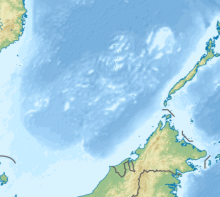
제임스 쇼알(James Shoal[1][6])은 말레이시아 보르네오 해안에서 약 45해리(83km; 52mi) 떨어진 남중국해 해저 22m(72ft)의 해저 모래톱이다.[1][7] 말레이시아, 중화인민공화국, 중화민국(대만)이 주장하고 있다. 그 모래톱과 그 둘레는 말레이시아에 의해 관리된다.
이름
이 구간은 확장이 필요하다. 덧셈으로 도움도 된다(2020년 8월) |
James Shoal is also called Beting Serupai[8] (Malaysia) and Zengmu Reef[9] / Zengmu Shoal[4] / Tseng-mu An-sha[6] (Chinese: 曾母暗沙[10]; pinyin: Zēngmǔ Ànshā; lit. '제임즈는 물에 잠긴 모래톱'(중국 본토와 대만)
역사
제임스 쇼알은 파슨스 쇼알(베팅 터가우, 八仙暗沙, 남쪽으로 9.35km)과 리디 쇼알(베팅 무카, 立地暗, 서남서쪽으로 27.94km)이라는 두 가지 인근 특성과 함께 19세기 초 영국의 조사관들에 의해 많은 조사를 통해 인정받았다. 제임스 쇼알은 1870년대에 영국 해군 차트에 처음 등장했다. 1933년 중화민국 정부 위원회는 남중국해의 많은 특징에 중국 이름을 붙였다. 이것들은 주로 영국 차트의 이름을 번역하거나 번역한 것이었다.[11] '제임스'라는 이름은 Zeng Mu로 번역되었다. '쇼알'은 모래톱을 의미하는 '탄'으로 번역되었다. 중국 위원회가 제임스 쇼알을 섬이라고 잘못 생각한 것 같다. 1947년에 RoC는 그 이름을 '신발' 또는 'ref'라는 뜻의 '안샤'[12]로 바꾸었다.
위치

보르네오 대륙붕의 말레이시아 빈툴루 북서쪽 약 45해리(83km; 52mi)에 위치한 이 모래톱은 말레이시아 해안에서 80km(50mi), 중국 본토에서 약 1,800km(1,100mi) 떨어져 있다. 지리적으로는 스프래틀리 제도의 남쪽에 위치하지만, 남중국해에서 주권을 둘러싼 국제적인 분쟁의 일환으로 때때로 그것들과 함께 묶이기도 한다.
이 모래톱은 말레이시아의 대륙붕과 200해리 EEZ 내에 있다.[13]
인근에는 파슨스 쇼알과 리디 쇼알이 있으며,[2] 북쪽으로는 97~223km에 이르는 루코니아 쇼알이 있다.
영토 분쟁
말레이시아의 주장
말레이시아의 모래톱 주장은 대륙붕 원리에 근거한 것으로, 대륙붕이 제임스 쇼알을 덮고 있는 나라는 말레이시아가 유일하다는 것이다. 국제법에서는 대륙붕을 200해리(최대 350해리)의 거리까지 한 나라의 땅덩어리를 자연적으로 확장한 것으로 정의하고 있다. 본토나 남중국해의 섬에서 끌어온 중국의 대륙붕은 제임스 쇼알에 한참 모자란다. 마찬가지로 제임스 쇼알도 베트남, 필리핀, 중화민국(대만)의 확장된 대륙붕에 속하지 않는다.[2]
2009년 5월, 베트남과 말레이시아는 유엔 대륙붕 한계 위원회(CLCS)에 확장 대륙붕에 대한 공동 제출서를 제출했고, 베트남은 제임스 숄이 확장 대륙붕에 속하지 않는다는 것을 인정했다.[13][2]
제임스 쇼알은 1971년 이후 필리핀이 점령한 스프래틀리스 섬(파가사)에서 500해리(930km, 580mi), 중화민국(대만)이 점령한 섬 이토아바에서 400해리(740km, 460mi)가 넘는 해상이다. 브루나이가 말레이시아와 가지고 있는 2009년 교환 서한이 증명하는 브루나이의 확장된 해상수역 밖이기도 하다. 1969년 말레이시아와 인도네시아는 사라왁의 탄중다투에서 떨어진 대륙붕에 조약을 맺어 제임스 쇼알을 말레이시아 쪽에 배치했다.[2]
말레이시아 사법권
말레이시아는 제임스 쇼알, 파슨 쇼알, 리디 쇼알 주변 지역을 포함한 대륙붕에 대한 관할권을 사실상 주장하고 있다. 말레이시아 당국의 활동으로는 24시간 내내 인근 파슨스 쇼알에 경구 건설 및 정비, 말레이시아 왕립 해군과 말레이시아 해양 단속국의 매일 순찰 및 치안 유지, 탄화수소 레스의 탐사 및 생산과 같은 경제 활동 등이 있다.어음을 계속하여 [2]어류로 삼다
국제법상 이런 평화적이고 지속적인 활동을 장기간에 걸쳐 보여주는 것은 십일조(주권자의 행위)를 세우는 것이나 다름없다.[2]
중국의 주장

이 모래톱은 중화인민공화국과 중화민국(대만)이 중국의 최남단 영토라고[6][9][14] 주장하고 있다. 중국은 1933년 영국 이름을 쩡무탄(zeng Mu Tan)으로 번역했고, 1947년 쩡무안샤(zeng Mu Ansha)로 개칭했다. 인민해방군 해군은 1981년 5월, 1994년 다시, 2013년 3월 26일에 모래톱을 방문했다.[15][16] 1990년 3월 26일, 다시 1992년 1월 15일, 2010년 4월 20일, 2012년 4월 20일, 중국 해양 감시선박들이 모래톱을 방문하여 모래톱 해역에 주권비(主主主義비록은 1990년 3월 26일, 다시 1992년 1월, 1995년 1월 15일에, 2010년 4월 20일에, 2012년에 중국 영토로 표시되었다.[17][18]
중국 관영 신화통신은 2014년 1월 29일 중국 군함 3척(수륙함 1척과 구축함 2척)이 제임스 쇼알에 돌아와 군사훈련을 하고 선서식도 했다고 보도했다.[19] 말레이시아 왕립 해군 총참모장 탄 스리 압둘 아지즈 자파르는 "중국군의 훈련은 공해상에서 북쪽으로 수백마일 떨어진 곳에서 이뤄졌다"고 보도 내용을 부인했다.[20]
중국 학생들은 학교에서 제임스 쇼알이 중국 영토의 최남단 지점이며, 나인다시선 내의 영토는 이웃 나라들의 섬과 주변 해역에 대한 분쟁에 대한 어떠한 언급도 없이 항상 중국의 영토라는 것을 가르치고 시험한다.[21]
2020년 7월 마이클 폼페오 미 국무장관은 이 주장에 대해 다음과 같이 썼다.
PRC는 말레이시아에서 50해리, 중국 해안에서 약 1,000해리 떨어진 곳에 완전히 잠기는 특색인 제임스 쇼알에 대한 합법적인 영토나 해상 청구권이 없다. 제임스 쇼알은 종종 PRC 선전에 "중국의 최남단 영토"로 언급된다. 국제법은 명확하다: 제임스 쇼알과 같은 수중 특성은 어느 주에서도 주장할 수 없으며 해양 지대를 생성할 수 없다. James Shoal (수면 아래 20미터 정도)은 PRC 영토도 아니고 결코 PRC 영토도 아니었으며, 중국도 그로부터 합법적인 해상권을 주장할 수 없다.[1][22][23][24][25]
석유 및 가스 매장량
말레이시아의 적극적인 석유·가스전 탐사와 개발은 2014년부터 제임스 쇼알 일대를 중심으로 진행되고 있으며, 주변 지역에 여러 생산시설이 세워져 있다. 말레이시아는 또한 탄화수소 자원의 탐사와 생산을 이 지역에서 지속적으로 수행해 왔으며, 이 지역에 대한 관할권을 사실상 주장하고 있다.[2][26]
참고 항목
참조
- ^ a b c d Michael Pompeo (13 July 2020). "U.S. Position on Maritime Claims in the South China Sea". State Department. Retrieved 22 July 2020.
- ^ a b c d e f g h "China's James Shoal Claim: Malaysia the Undisputed Owner". RSIS (Rajaratnam School of International Studies), Nanyang Technology University, Singapore. 1 July 2014.
- ^ 국무회의 산샤시 설치와 관련해 PRC 민정부 발표( (民政关务-----------------中國人民人人民政部部部) 웨이백머신에 2012-06-25 보관(중국어)
- ^ a b "Peace in the South China Sea, National Territory Secure Forever Position Paper on ROC South China Sea Policy" (PDF). Ministry of Foreign Affairs (Taiwan). p. 14.
Zengmu Shoal in the south
- ^ Lung Tsun-Ni 龍村倪 (1998). 東沙群島-東沙島紀事集錦 (in Chinese). Taipei: 臺灣綜合研究院. p. 6. ISBN 957-98189-0-8.
南海諸島圖{...}中華民國{...}曾母暗沙{...}《中華民國全圖》內政部/台北/民87.3.1998
(참고: 이 페이지의 지도에서 제임스 쇼알은 나인대쉬 선의 가까운 변종 또는 이와 유사한 점선으로 보이는 내부에 표시된다. 점선 안쪽에는 '중국 공화국'이라는 라벨이 붙어 있다.) - ^ a b c "SOUTH CHINA SEA: UP FOR GRABS" (PDF). Bureau of Intelligence and Research. 14 September 1971. p. 5. Archived (PDF) from the original on 23 January 2017.
2) James Shoal (Tseng-mu An-sha) 4°N., 112°15'E., marks the southern extent;
- ^ "Sector 11 - Borneo Northwest Coast" (PDF). Sailing Directions pub. 163. US NGA. p. 305.
Parsons Shoal (Beting Tugau) (3˚54'N., 112˚15'E.), with a depth of 20m, lies 12.32 miles ENE of Lydie Shoal. James Shoal (Beting Serupai), Beting Serupai, with a depth of 22m, lies 15 miles NE of the same shoal. During the Northeast Monsoon (October to March), a distinct line of tide rips may be seen in the vicinity, particularly W of these shoals. Beting Tugau is marked by Beting Tugau Lighted Buoy. A shoal, with two heads having depths of 21m and 22m, lies 13 miles SSE of Parsons Shoal.
- ^ Sumathy Permal (23 January 2015). "South China Sea Manoeuvrings: More of the same in 2015?" (PDF). Sea Views (2). Retrieved 6 August 2020 – via Maritime Institute of Malaysia.
- ^ a b "Boundary". Embassy of the People's Republic of China in the Republic of North Macedonia. Archived from the original on 23 July 2020. Retrieved 23 July 2020 – via Internet Archive.
From north to south, theterritory of China measures some 5,500 km, stretching from the center of the Heilongjiang River north of the town of Mohe to the Zengmu Reef at the southernmost tip of the Nansha Islands.
- ^ "中華民國南海政策說帖" (PDF) (in Chinese). 中華民國外交部. p. 14.
- ^ 빌 헤이튼, 남중국해 : 아시아의 권력투쟁, 2장
- ^ Bill Hayton (9 February 2013). "How a non-existent island became China's southernmost territory". South China Morning Post.
- ^ a b "Joint Submission to United Nations Commission on the Limits of the Continental Shelf (CLCS)" (PDF). United Nations. 20 May 2009. Retrieved 15 March 2015.
- ^ 中華民國政府繪製南海諸島範圍線之決策過程及其意涵 - 國史館 (PDF). p. 99.
- ^ "Chinese navy exercises 'surprise' neighbours". Al Jazeera English. 27 March 2013. Retrieved 13 September 2013.
- ^ "The Beting Serupai incident". New Straits Times. 16 April 2013. Retrieved 13 September 2013.
- ^ 南沙权碑碑故故故故故故ha故(난사군도의 주권에 관한 이야기).2015-02-25. 《中国海洋报》.作者:罗茜.
- ^ 我在曾母暗沙投下祖国界碑 (I dropped a boundary tablet in Zeng Mu Ansha). 赵林如.《今日国土》. 2011年第一期.
- ^ "Loss of James Shoal could wipe out state's EEZ". The Borneo Post. 5 February 2014. Retrieved 17 May 2014.
- ^ "Chinese ships patrol area contested by Malaysia". reuters.com. Thomson Reuters. 26 January 2014. Retrieved 8 February 2014.
- ^ Zheping Huang; Echo Huang (13 July 2016). "China's citizens are livid at the South China Sea ruling because they've always been taught it is theirs". Quartz.
- ^ Lin Ching-Ping 林憬屏, ed. (14 July 2020). 蓬佩奧:中國對南海主權聲索「完全非法」. Central News Agency (in Chinese). Retrieved 22 July 2020.
美方也在聲明中反對中國對曾母暗沙(James Shoal)聲索主權。聲明指出,北京對外宣稱曾母暗沙為「中國最南端領土」,但曾母暗沙為水下地物,依據國際法任何國家不得提出主權聲索,且其離馬來西亞僅50海里,但距離中國沿岸有1000海里遠。
- ^ Bill Hayton (15 July 2020). "Pompeo Draws a Line Against Beijing in the South China Sea". Foreign Policy. Retrieved 10 August 2020.
The United States, quite sensibly, has never taken a position on which country is the rightful owner of these territories. However, Pompeo’s statement breaks new ground by asserting that China has “no lawful territorial or maritime claim to (or derived from) James Shoal.”
- ^ Laura Zhou (14 July 2020). "'Heightened risk' of military conflict over South China Sea, observers warn". South China Morning Post. Retrieved 11 August 2020.
The statement also said China’s claims over the submerged feature James Shoal near Malaysia were unlawful.
- ^ "U.S. Repudiates China's Maritime Claims in South China Sea". Voice of America. 21 July 2020. Retrieved 11 August 2020.
On July 13, Secretary of State Mike Pompeo said in a written statement that the U.S. position on China’s maritime claims in the South China Sea is aligned with key aspects of the Tribunal’s decision.“Beijing’s claims to offshore resources across most of the South China Sea are completely unlawful, as is its campaign of bullying to control them.” This means that the United States does not recognize Beijing’s maritime claims to waters within the 370 kilometer [200 nautical mile] Exclusive Economic Zone of another country beyond a lawful territorial sea generated from islands it claims in the Spratlys, nor do we recognize its claims to underwater features like James Shoal or low-tide elevations like Mischief Reef and Second Thomas Shoal, which, under international law, may not be claimed by any state and are incapable of generating maritime zones of their own.
- ^ "IndoPacificReview". Archived from the original on 24 September 2015. Retrieved 15 March 2015.
외부 링크
- TPC L-11D 인도네시아(맵), 미 국방지도국 항공우주센터 1984년 편찬


