시몬스 섬
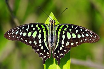
Simmons Island 시몬스 섬의 USGS 공중사진 | |
 시몬스 섬  시몬스 섬  시몬스 섬  시몬스 섬 | |
| 지리 | |
|---|---|
| 위치 | 북캘리포니아 주 |
| 좌표 | 38°05′49″N 121°59′26″w / 38.09694°N 121.99056°W[1]좌표: 38°05′49″N 121°59′26″W / 38.09694°N 121.99056°W/ 섬[1] |
| 인접 수역 | 쑤이순 만 |
| 관리 | |
| 주 | |
| 카운티 | 솔라노 |

시몬스 섬은 캘리포니아 주 샌프란시스코 베이 지역의 그리즐리 만(수이순 만 일부)에 있는 작은 섬이다.[2][3][4][5][6][7][8][9][10][11][12][13][14][15] [16] 솔라노 현에 속하며, 2127번 간척지구에 포함된다.[17] 좌표는 38°05°49°N 121°5이다.9′26″W / 38.09694°N 121.99056°W/ [1] 캐드왈더 링골드가 만든 샌프란시스코만 지역의 1850년 측량 지도에는 '시몬스 섬'으로,[18] 1854년 헨리 랭지가 그린 이 지역 지도에는 '시몬스 섬'으로 표시된다.[19] 1902년 USGS 지도에는 데드만 섬, 조이스 섬, 그리즐리 섬, 라이어 섬, 로 섬과 함께 라벨이 붙어 있다.[20]
참조
- ^ a b 미국 지질조사국 지리적 이름 정보 시스템: 시몬스 섬
- ^ "Duck Club Keeper Found Drowned". Contra Costa Gazette and Martinez Daily Standard. Martinez, California. 1932-06-21. p. 4.
- ^ "Rod and Gun". The San Francisco Examiner. San Francisco, California. 1946-11-22. p. 26.
- ^ "Sportsmen's Corner". Visalia Times-Delta. Visalia, California. 1951-10-17. p. 10.
- ^ "Rod and Gun". The San Francisco Examiner. San Francisco, California. 1951-11-13. p. 26.
- ^ "Fight Among Fishermen Leads To $30,000 Suit". Contra Costa Gazette. Martinez, California. 1955-04-18. p. 2.
- ^ "Sports Afield: Duck Hunters Grin as Opener Shows Bumper Crop of Birds". The San Francisco Examiner. San Francisco, California. 1960-10-18. p. 51.
- ^ "Sports Afield: Waterfowl Filberts Sacking Limits of Sprig and Mallard". The San Francisco Examiner. San Francisco, California. 1960-10-25. p. 52.
- ^ "Duck Hunting Areas Full". The San Francisco Examiner. San Francisco, California. 1960-12-13. p. 64.
- ^ "State Resets Suisun Bay Oil-Gas Bidding Date". The Sacramento Bee. Sacramento, California. 1967-11-08. p. 39.
- ^ "Legal Notice". Concord Transcript. Concord, California. 1967-11-09. p. 10.
- ^ "$3.9 Million Project Aimed At Protecting Suisun Marsh". The Sacramento Bee. Sacramento, California. 1978-12-20. p. 5.
- ^ "Supreme Court scuttles Sierra Club case against Central Valleys Project". The Fresno Bee. Fresno, California. 1981-05-05. p. 31.
- ^ "Weather threatens oil spill cleanup". The Hanford Sentinel. Hanford, California. 1988-04-28. p. 7.
- ^ "Grizzly Island offers taste of the wild life". The Press Democrat. Santa Rosa, California. 1989-03-30. p. 23.
- ^ California State Automobile Association (1999). San Francisco Bay Region (Map). 1:190,000. American Automobile Association.
- ^ "Municipal Service Review: Solano County Water, Irrigation, Reclamation, and Flood Management Agencies" (PDF). Solano County LAFCO. Michael Brandman Associates. 13 April 2009. Archived (PDF) from the original on 14 March 2021. Retrieved 23 February 2021.
- ^ Ringgold, Cadwalader; Stuart, Fred D.; Everett, Chas.; Harrison (1850). "General Chart embracing Surveys of the Farallones Entrance to the Bay of San Francisco, Bays of San Francisco and San Pablo, Straits of Carquines and Suisun Bay, and the Sacramento and San Joaquin Rivers, to the Cities of Sacramento and San Joaquin, California". David Rumsey Map Collection. San Francisco Common Council. Archived from the original on 7 July 2017. Retrieved 25 February 2021.
- ^ Lange, Henry (1854). "Bai San Francisco und Vereinigung des Sacramento mit dem San Joaquin". David Rumsey Map Collection. George Westermann. Archived from the original on 10 March 2016. Retrieved 25 February 2021.
- ^ Goode, R.U.; Fletcher, L.C. (1902), Topography, State of California: Woodward Island Quadrangle, United States Geological Survey
|