리틀 홀랜드 트랙스
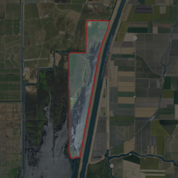
Little Holland Tract USGS 공중사진 리틀 홀랜드 트랙 | |
| 지리 | |
|---|---|
| 위치 | 북캘리포니아 주 |
| 좌표 | 38°19′27″N 121°39′20″w / 38.32417°N 121.6556°W[1]좌표: 38°19′27″N 121°39′20″W / 38.32417°N 121.6556°W/ [1] 홀랜드 ) |
| 인접 수역 | 새크라멘토-산호아킨 강 삼각주 |
| 최고 고도 | 13피트(4m)[1] |
| 관리 | |
미국 | |
| 주 | |
| 카운티 | 인생은 한 번뿐이다. |
리틀 홀랜드 트랙스는 캘리포니아 욜로 카운티에 있는 새크라멘토-산 호아킨 강 삼각주에 있는 부분적으로 물에 잠긴 섬이다.[2] 좌표는 38°191927″N 121°3이다.9 in20 geologicalW / 38.32417°N 121.6556°W/ [1] 및 미국 지질조사국은 1981년에 13ft(4.0m)로 상승하였다.[1] 그것은 1952년 USGS 지도에 큰 직사각형 트랙으로 나타나며, 1978년까지 조사 지도에 새크라멘토 강 심층수선 해협에 의해 대각선으로 절단된 것을 보여준다.[3][4]
참조
- ^ a b c d 미국 지질조사국 지리적 이름 정보 시스템: 리틀 홀랜드 트랙스
- ^ "More islands submerged in Delta floods". North East Bay Independent and Gazette. Berkeley, California. 1980-02-22. p. 1.
- ^ United States Geological Survey (1952). "Liberty Island Quadrangle, California" (Map). United States Department of the Interior Geological Survey. 1:24000.
- ^ United States Geological Survey (1978). "Liberty Island Quadrangle, California" (Map). United States Department of the Interior Geological Survey. 1:24000.


