나라별 가장 습한 열대성 사이클론 목록

List of wettest tropical cyclones by country

이것은 알려진 모든 가능한 공급원을 사용하는 국가별 가장 습한 열대 사이클론 목록이다. 자료는 호주, 쿠바, 도미니카공화국, 일본, 홍콩, 멕시코, 대만, 미크로네시아의 야프·추욱, 미국 등에 대해 가장 완벽하며, 단편적인 자료는 다른 나라에서도 이용할 수 있다. 프랑스 레유니온 지역은 거친 지형도와 인도양에서의 위치 때문에 열대성 사이클론과 전세계적인 강우량 세계 기록을 보유하고 있다.[1]

1985년과 2005년 사이의 기간을 포함하는 모든 열대 사이클론 트랙의 지도.

아래는 위의 각 국가에 대한 기록이다.

앤티가 바부다

허리케인 얼(2010)
앤티가 바부다에 있는 열대성 사이클로인과 그 잔해들
가장 많이 알려진 총계
강수량 스톰 위치 Ref.
순위 mm in
1 465.3 18.32 레니 1999 V. C. 버드 국제공항 [2]
2 252.5 9.94 루이스 1995 V. C. 버드 국제공항 [3]
3 245.8 9.68 프레데릭 1979 V. C. 버드 국제공항 [3]
4 232.6 9.16 오마르 2008년 V. C. 버드 국제공항 [3]
5 198.3 7.81 얼 2010 V. C. 버드 국제공항 [3]
6 194.1 7.64 호세 1999 V. C. 버드 국제공항 [3]
7 188.9 7.44 휴고 1989년 V. C. 버드 국제공항 [3]
8 163.6 6.44 데이지 1962 V. C. 버드 국제공항 [3]
9 159.2 6.27 아이리스 1995 V. C. 버드 국제공항 [3]
10 146.9 5.78 라파엘 2012 V. C. 버드 국제공항 [3]

호주.

사이클론 피터
호주에서 가장 습한 열대성 사이클론 및 그 잔해
가장 많이 알려진 총계
강수량 스톰 위치 Ref.
순위 mm in
1 1,947 76.65 피터 1979년 벨렌덴 케르 산 [4]
2 1,870 73.62 로나 1999 벨렌덴 케르 산 [4]
3 1,318 51.89 완다 1974년 영광스러운 산 [5]
4 1,256.8 49.48 플레처 2014 코와야마 [6][7]
5 1,082 42.60 아이부 1989년 달림플 하이츠 [8]
6 1,065 41.93 1998년 5월 버켓타운 [9]
7 1,000 39.37 저스틴 1997 윌리스 섬 [10]
7 1,000 39.37 엘리 2009 [11]
7 1,000 39.37 오스왈드 2013 툴리 [12]
8 986 38.82 데비 2017 클라크 범위 [13]

크리스마스 섬

사이클론 길시언

크리스마스 아일랜드(Christmas Island)는 인도양에 위치한 호주의 영토로, 열대 우림대가 지배하는 중앙 고원까지 가파르게 솟아 있다.[14] 1972년 이 섬에서 강우량 및 풍랑 관측을 시작한 후 1972년부터 2005년 사이 이 섬에서 220km(135mi) 이내에 13개의 열대 사이클론만이 통과했다.[14]

가장 습한 열대성 사이클론들과 크리스마스 섬의 잔해들
가장 많이 알려진 총계
강수량 스톰 위치 Ref.
순위 mm in
1 368.2 14.5 달리아 2017 크리스마스 아일랜드 공항 [15]
2 220.2 8.67 02U 2021년 크리스마스 아일랜드 에어로 [16]
3 181.0 7.13 길시언 2014 크리스마스 아일랜드 공항 [17]
4 102.4 4.03 제이콥 2007 크리스마스 아일랜드 공항 [18]
5 65.0 2.56 체실리 1973 [19]
6 52.8 2.08 로지 2008 크리스마스 아일랜드 공항 [20]
7 38 1.50 노라 1974년 [21]
8 17 0.67 데니스 1975년 [22]

코코스 제도

2013년 트로피컬 로우 11U는 코코스 제도에서 120km(75mi) 이상 떨어져 있었지만, 윈드 시어는 며칠 동안 서부와 섬 상공에서 대류를 역전시켜 기록적인 강우량을 기록했다.[23]

코코스(Keeling) 열도는 호주령 27개 산호섬으로 이루어진 영토로, 두 개의 큰 산호섬으로 이루어져 있으며, 호주 퍼스 북서쪽 인도양의 약 36km2(14평방mi)의 면적을 차지하고 있다.[14] 1907년 강우량 관측은 이 섬에서 시작되었고 온도, 바람, 그리고 다른 기록들은 1952년에 시작되었다.[14] 1952년과 2005년 사이 27개의 열대성 사이클론은 이 섬에 90km/h(55mph)가 넘는 돌풍을 일으켰고, 4개만이 125km/h(80mph) 이상의 허리케인 돌풍을 일으켰다.[14]

코코스 제도의 열대성 사이클론 및 잔해
가장 많이 알려진 총계
강수량 스톰 위치 Ref.
순위 mm in
1 844.6 33.25 2013년 11월 코코스 섬 공항 [23]
2 298.0 11.73 페드로1989번길 [14]
3 170.0 6.69 월터 2001 [24]
4 160.0 6.30 아델린줄리에트 2005 [25]
5 127.0 5.00 디드레-달리다 1973년 [26]
6 115.0 4.53 브루스 2013 코코스 섬 공항 [27][28]
7 107.6 4.24 케이트 2014 코코스 섬 공항 [29][30]
8 89.4 3.52 노라 1974년 [21]
9 66.9 2.63 애니 1973 [31]
10 56.0 2.20 안그렉 2010 코코스 섬 공항 [32]

바하마

바하마 상공의 열대성 폭풍 노엘
바하마에서 가장 습한 열대성 사이클론 및 그 잔해
가장 많이 알려진 총계
강수량 스톰 위치 Ref.
순위 mm in
1 747.5 29.43 노엘 2007 롱아일랜드 [33]
2 580.1 22.84 도리안 2019 호프타운 [34]
3 500.3 19.70 매슈 2016 이나구 매슈타운 [35]
4 436.6 17.19 플로라 1963 던컨 타운 [36]
5 390.1 15.36 이네즈 1966 나소 공항 [36]
6 337.1 13.27 폭스 1952 뉴 프로비던스 [36]
7 321.1 12.64 미셸 2001 나소 [37]
8 309.4 12.18 에린 1995 처치 그로브 [38]
9 260.0 9.88 2008년 페이 프리포트 [39]
10 236.7 9.32 플로이드 1999 리틀 하버 아바코스 [40]

방글라데시

2015년 7월 29일 방글라데시로 접근하는 사이클론 코멘

방글라데시는 최근 열대성 저기압 사상자가 가장 큰 현장이었다. 그 나라는 상당히 평탄하고 일반적으로 해수면 근처에 있다.

방글라데시의 열대성 사이클론 및 잔해
가장 많이 알려진 총계
강수량 스톰 위치 Ref.
순위 mm in
1 1,051.2 41.39 코멘 2015 치타공 [41]
2 ~300 ~12.00 라슈미 2008 [42]
3 280 11.02 몬순 대공황 — 2004년 9월 바리살 [43]
4 253 10.00 비야루 2013 파투아칼리 [44]
5 227.2 8.94 열대우림 — 2004년 10월 랑푸르 [45]
6 220.0 8.66 볼라 1970 마야 반다르 [46]
7 200 7.87 2007년 시드르 [47]
8 130 5.11 아일라 2009 치타공 [48]
9 129 5.07 비즐리 2009 [49]
10 53 2.13 아카시 2007 [50]

벨리즈

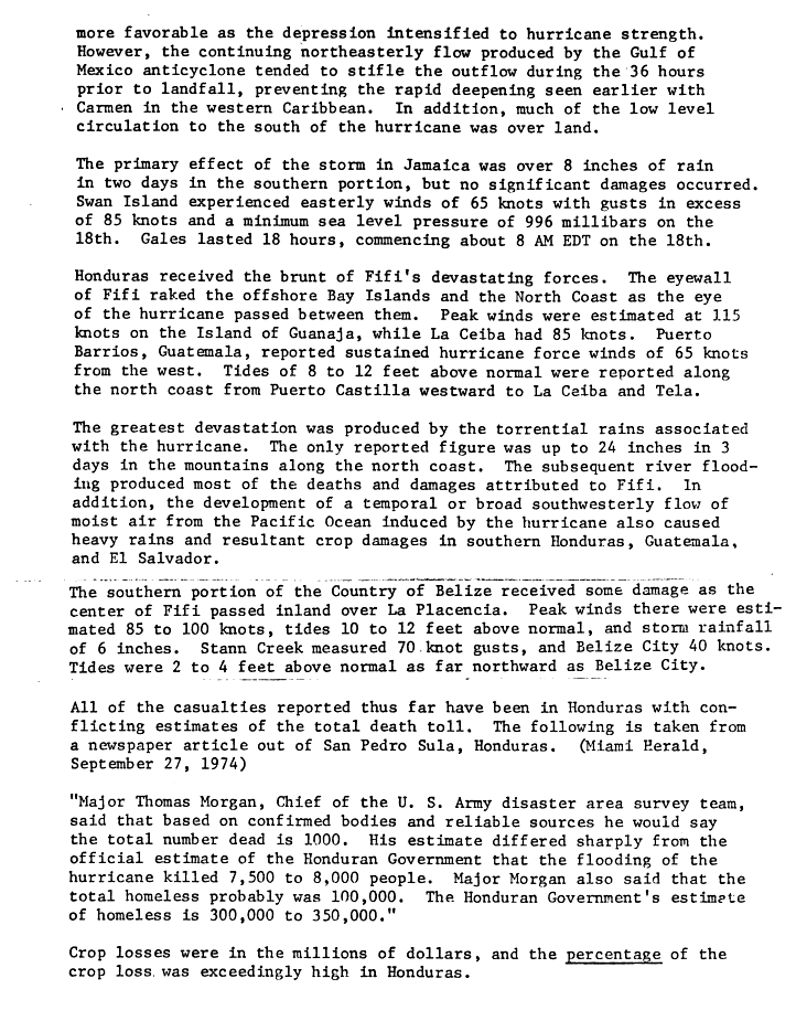
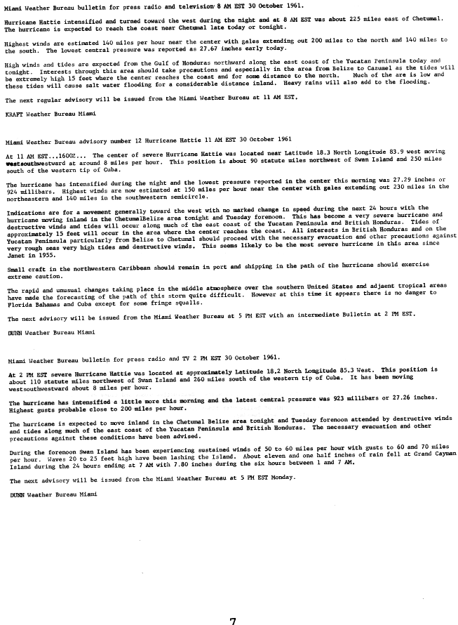
이 나라는 주로 남쪽 지역을 가로질러 지형을 가지고 있으며, 고도는 약 3,700피트(1,100m)까지 올라간다.[51] 이전에 영국 온두라스였던 곳에서 가장 높은 강수량은 2000년 허리케인 키스 때 발생했는데 그 때 벨리즈 의 필립 굿슨 국제공항에서 24시간 동안 32.67인치(830mm)의 비가 내렸다.[52] 1961년의 허리케인 해티와 1974년의 허리케인 피피에도 똑같이 많은 비가 내릴 수 있었다.

허리케인 키스(2000년)
벨리즈에서 가장 습한 열대성 사이클론 및 그 잔해
가장 많이 알려진 총계
강수량 스톰 위치 Ref.
순위 mm in
1 829.8 32.67 키스 2000 필립 골드슨 공항 [53]
2 555.2 21.86 에타 2020 발디 비컨 [54]
3 546.6 21.52 2008년 16세 발디 비컨 [55]
4 299.7 11.80 아만다 2020 벨모판 [56]
5 249.2 9.81 샹탈 2001 타워힐 [57]
6 246.0 9.69 미치 1998 중앙농장기상역 [58]
7 241.0 9.49 게르트 1993 헌팅 케이 [59]
8 179.0 7.05 그레타 1978 중앙농장기상역 [58]
9 152.4 6.00 피피 1974년 라 플라센시아 [60]
10 131.0 5.16 헤르미네 1980 중앙농장기상역 [58]

캄보디아

태풍 린다(1997년)
캄보디아에서 가장 습한 열대성 사이클론 및 그 잔해
가장 많이 알려진 총계
강수량 스톰 위치 Ref.
순위 mm in
1 404.1 15.91 1997년 린다 콤팟 [61]
2 240.0 9.45 바이올렛 1964 박사 [62]
3 30.5 1.20 페이스 1998 콤퐁참 [63]

캐나다

노바스코샤 인근 열대 사이클론 하비

열대성 사이클론은 캐나다 대서양에 도달할 때쯤이면 보통 열대의 상태를 유지하지만, 열대의 온대성 사이클론으로 전환되고 있다. 캐나다의 태평양 연안을 강타한 열대성 사이클론은 아직까지 없다.

캐나다에서 가장 습한 열대성 사이클론 및 그 잔해
가장 많이 알려진 총계
강수량 스톰 위치 Ref.
순위 mm in
1 302.0 11.89 하비 1999 옥스퍼드, NS [64]
2 249.9 9.84 1971년 베스 핼리팩스, NS [65]
3 238.0 9.37 이고르 2010 세인트로렌스, NL [66]
4 224.8 8.85 매슈 2016 시드니, NS [67]
5 213.6 8.41 헤이즐 1954 스넬그로브, ON [68]
6 200.4 7.89 2007년 샹탈 아르헨티나, NL [69]
7 191.0 7.52 베르타 1990 NS 헌터즈 마운틴 [70]
8 185.0 7.28 샌디 2012 Charlevoix, QC [71]
9 175.0 6.90 가브리엘 2001 세인트존스, NL [72]
10 165.0 6.50 크리스토발 2008 바카로 포인트, NS [73]
10 165.0 6.50 레슬리 2012 NS 슈베나카데미 [74]

중국

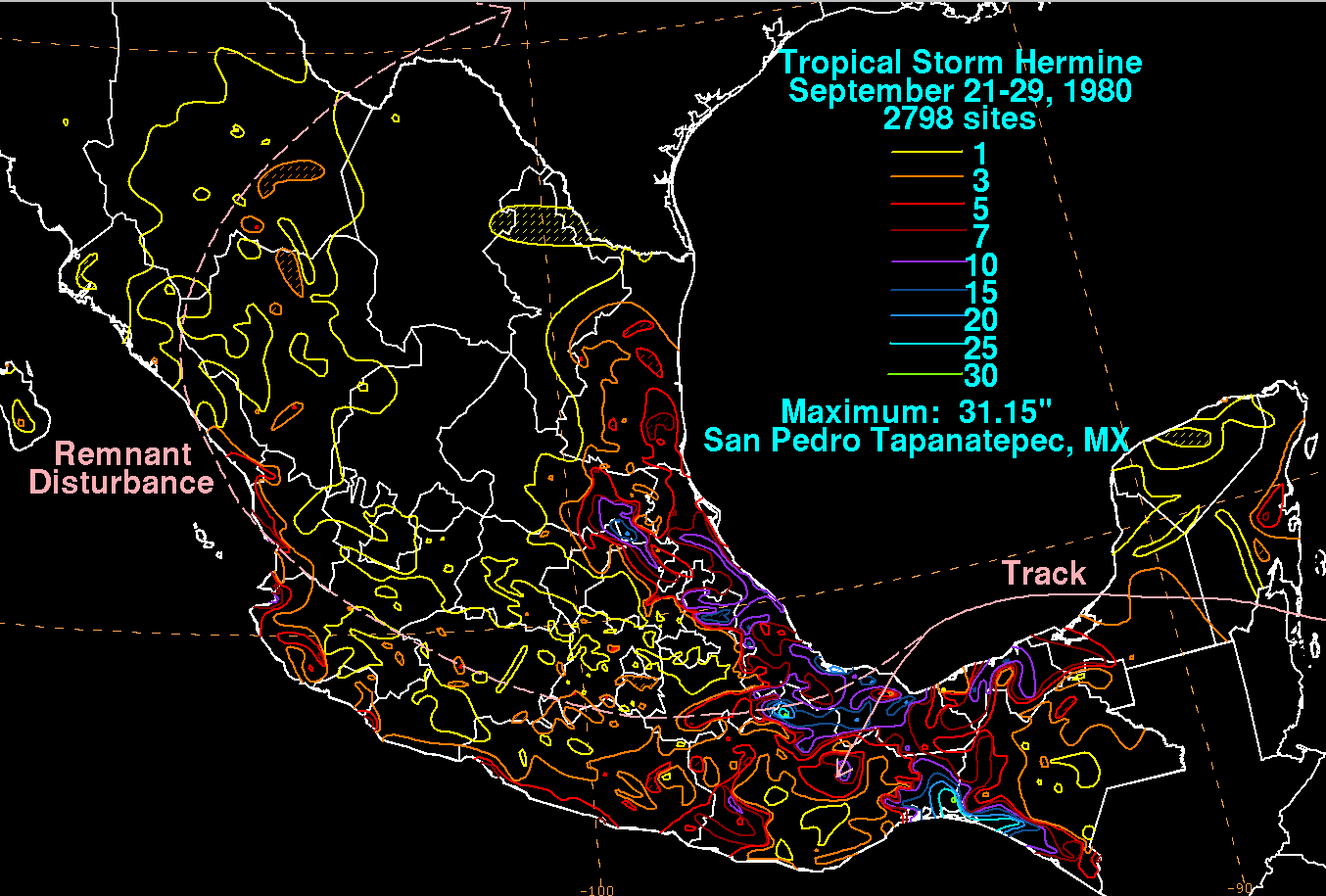
중국은 산악 국가로서 내륙으로 이동하는 사이클로인의 빠른 방산과 더불어 흩어지는 사이클로인의 상당한 양의 비가 내린다. 태풍 니나(1975)는 중국 본토 기록인 24시간 동안 허난에서 1062밀리미터(41.8인치)가 떨어지면서 거대한 저수지 2개와 소형 댐 10개가 붕괴됐다. 1999년 태평양 태풍의 태풍 샘은 1884년 기록이 시작된 이래 가장 습도가 높은 열대성 사이클론이 되어 73년의 기록을 깼다.[75] 열대성 사이클론과 그 잔해와 관련된 강수량은 티벳에 눈을 가져올 수 있다. 2004년 10월 초 열대성 저기압으로 인해 하루 6센티미터(2.4인치)의 액체 등가 강수량이 폭설 형태로 체구군에 유입되었는데, 이는 비와 눈이 모두 내린 10월 일일 강수량 기록이다. 이로 인해 눈보라 속에서 식량 34만 kg, 식량 23만 kg, 가축 263마리를 잃었다.[76]

태풍 수델로르/한나

본토

가장 습한 열대성 사이클론 및 그 잔해 중국 본토
가장 많이 알려진 총계
강수량 스톰 위치 Ref.
순위 mm in
1 1062.0 41.81 니나 1975년
2 951.0 37.4 인파로2021번길 유야오 [77]
3 831.1 32.72 2001년 피토우 [78]
4 806.0 31.73 2015년 수델로르 원저우 [79]
5 703.5 27.70 라나니 2004 [80]
6 662.0 26.01 찬투로2021번길 주산 딩하이 [81]
7 >600.0 >24.00 하이쿠이 2012 안후이 성 [82]
8 555.0 21.85 찬추 2006 [83]

홍콩

태풍 샘
가장 습한 열대성 사이클론 및 그 잔해 홍콩
가장 많이 알려진 총계
강수량 스톰 위치 Ref.
순위 mm in
1 616.5 24.27 1999년 3월 홍콩 천문대 [84]
2 597.0 23.50 1926년 7월 태풍 홍콩 왕립 천문대 [84]
3 562.0 22.13 1916년 6월 태풍 홍콩 왕립 천문대 [84]
4 530.7 20.89 아그네스 1965 홍콩 왕립 천문대 [84]
5 519.0 20.43 아그네스 1978 홍콩 왕립 천문대 [84]
6 516.1 20.32 엘렌 1976년 홍콩 왕립 천문대 [84]
7 497.5 19.59 도트 1993 홍콩 왕립 천문대 [84]
8 491.7 19.36 도트 1982 홍콩 왕립 천문대 [84]
9 480.9 18.93 헬렌 1995 홍콩 왕립 천문대 [84]
10 473.2 18.63 1904년 8월 태풍 홍콩 왕립 천문대 [84]

코스타리카

허리케인 세자르
코스타리카의 열대성 사이클론 및 잔해
가장 많이 알려진 총계
강수량 스톰 위치 Ref.
순위 mm in
1 920.0 36.22 세자르 1996 알토 데 티나마스테 [85]
2 624.4 24.58 에타 2020 아루나찰라 [54]
3 487.4 19.19 네이트 2017 마리마 [86]
4 466.6 18.37 미치 1998 자코 [87]
5 376.4 14.82 2008년 알마 퀘포스 [88]
6 331.5 13.05 게르트 1993 알 수 없는 [89]
7 308.0 12.11 오토 2016 미라발레스 화산 [90]

쿠바

1963년 10월의 허리케인 플로라는 나흘 동안 쿠바를 가로질러 표류했고, 그 산악 섬나라를 가로질러 극도의 강우량을 기록했다. 24시간 동안 가장 많은 비가 내린 기간 동안, 735밀리미터(28.9인치)의 비가 산티아고 데 쿠바에 내렸다. 쿠바에서는 4일 동안 2,033밀리미터(80.0인치), 5일 동안 2,550밀리미터(100인치)[91]의 총량이 2000명 이상이 사망한 가운데 엄청난 인명피해를 냈다.

허리케인 데니스
쿠바에서 가장 습한 열대성 사이클론 및 그 잔해
가장 많이 알려진 총계
강수량 스톰 위치 Ref.
순위 mm in
1 2,550 100.39 플로라 1963 [91]
2 1,092 42.99 데니스 2005 [91]
3 1,025 40.35 T.D. #1 1988 [91]
4 1,012 39.84 알베르토 1982 [91]
5 870 34.25 프레데릭 1979 [91]
6 849 33.43 T.D. #1 1992 [91]
7 825 32.48 로라 1971 [91]
8 800 31.50 아이린 1999 [91]
9 754 29.69 미셸 2001 [91]
10 747 29.41 릴리 1996 [91]

도미니카

도미니카 인근 에리카

카리브해 동부의 섬들은 주로 8월과 10월 사이에 열대성 폭풍허리케인의 위협을 끊임없이 받고 있다. 도미니카는 4,750피트(1,450m)에 가까운 고도가 있는 험준한 섬이다.[92] 허리케인 잔느가 이 지역을 통과하면서 2004년 9월 15일 오전에 끝난 24시간 동안 422.3밀리미터(16.63인치)의 비가 내렸다.[93]

도미니카의 열대성 사이클론 및 잔해
가장 많이 알려진 총계
강수량 스톰 위치 Ref.
순위 mm in
1 800–850 31–33 에리카 2015 모르네 디아블로틴스 [94]
2 579.1 22.80 마리아 2017 콥홀 [95]
3 422.3 16.63 잔 2004년 [93]
4 246.4 9.70 에디스 1963 [36]
5 215.9 8.50 데이비드 1979년 로사우 [96]
6 150.1 5.91 애비 1960 [97]
7 79.5 3.13 아이사이아스 2020 솔즈베리 [36]
8 20.6 0.81 플로라 1963 [36]

도미니카 공화국

도미니카 공화국 인근의 노엘

도미니카 공화국은 카리브해를 둘러싸고 있는 가장 높은 지형을 가지고 있으며, 피코 두아르테는 해발 3,300m에서 정점을 찍고 있다.[98] 아래 목록에 있는 열대성 사이클론 강우량의 대부분은 최대 24시간이다. 이는 폭풍의 총량을 나타내지 않을 가능성이 높다.

가장 습한 열대성 사이클론 및 그 잔해 도미니카 공화국
가장 많이 알려진 총계
강수량 스톰 위치 Ref.
순위 mm in
1 1001.5 39.43 플로라 1963 폴로 바라호나 [36]
2 905.0 35.63 노엘 2007 안젤리나 [99]
3 598.0 23.54 클레오 1964년 폴로 [36]
4 528.0 20.79 에밀리 2011 네이바 [100]
5 505.2 19.89 잔 2004년 이슬라 소나 [101]
6 479.8 18.89 이네즈 1966 폴로 [102]
7 445.5 17.54 허리케인 4 1944 혼도발레 [103]
8 391.4 15.41 1935년 허리케인 5호 바라호나 [104]
9 359.9 14.17 한나 2008 오피도 [105]
10 350.0 13.78 T.S. 원 1948 바야구아나 [106]

엘살바도르

열대성 저기압 12-E(2011년)
엘살바도르에서 가장 습한 열대성 사이클론 및 그 잔해
가장 많이 알려진 총계
강수량 스톰 위치 Ref.
순위 mm in
1 1513 59.57 12 E(2011년) 후이주카르, 라 리베르타드 [107][108][109]
2 1.017 40.03 아만다 2020 [110]
3 861 33.90 미치 1998 [108]
4 766 30.16 스탠 2005 [108]
5 676 26.61 폴 1982 [108]
6 672 26.46 아가타 2010 [111]
7 603 23.74 매슈 2010 [108]
8 275.4 10.84 에타 2020 플레인즈 드 몬테크리스토 [54]

피지

사이클론 키나
가장 습한 열대성 사이클론 및 피지의 잔해
가장 많이 알려진 총계
강수량 스톰 위치 Ref.
순위 mm in
1 1,139 44.84 월리 (1980년) 사키사 [112]
2 1,040 40.94 키나(1992-93) 모나사부 댐 [113]
3 913 35.94 04F(2016년) 모나사부 댐 [114]
4 755 29.72 베베 (1972) 나수보우 [115]
5 744 29.29 아나(2021년) 드레케틸레일라이 [116]
6 697 27.44 개빈(1985) 모나사부 댐 [117]
7 615 24.21 개빈(1997년) 모나사부 댐 [118]
8 545 21.46 6월 (1997년) 마테이 [119]
9 529 20.83 이반(2012년) 모나사부 댐 [120]
10 508 20.00 2017년 9월 나가도 [121]

화산섬인 피지의 오로그래피는 대략 일년에 한 번 발생하는 열대성 사이클론 통로를 지나는 동안 상당한 강우량을 가져왔다.

프랑스.

프렌치 폴리네시아

사이클론 와사
프랑스령 폴리네시아의 열대성 사이클론 및 그 잔해
가장 많이 알려진 총계
강수량 스톰 위치 Ref.
순위 mm in
1 550 21.65 02F 1998년 타히티 [122]
2 356 14.02 주디 2004 타카로아 [123]
3 241 9.49 와사 1991 우투로아 [124]
4 149 5.87 팸 1997 라로통가 [125]
5 62.1 2.44 지타 2007 루루투 [126]

과들루프

허리케인 마릴린은 1995년 9월 중순 이 섬을 직접 가로질러 이동했으며,[127] 열대성 사이클론으로부터 이 섬에 가장 높은 강수량을 기록했다.

허리케인 루이스
과들루프의 열대성 사이클론 및 잔해물
가장 많이 알려진 총계
강수량 스톰 위치 Ref.
순위 mm in
1 582 22.91 루이스 1995 덴트 드 레스트 (수프리에르)
2 508 20.00 마릴린 1995 생클로드 [36]
3 466 18.35 레니 1999 젠더메리 [128]
4 389 15.31 휴고 1989년
5 318 12.52 호텐스 1996 마이슨 뒤 화산 [129]
6 300 11.81 잔 2004년 [130]
7 223.3 8.79 클레오 1964년 데샤이 [36]
8 200 7.87 에리카 2009 [131]
9 165.3 6.51 얼 2010 사인 로즈 (Viard) [132]
10 53.6 2.11 에디스 1963 바스 테르 [36]

마르티니크

마르티니크는 카리브해 동쪽 변두리에 있는 산악 섬이다.

마르티니크의 열대성 사이클론 및 잔해
가장 많이 알려진 총계
강수량 스톰 위치 Ref.
순위 mm in
1 680.7 26.80 도로시 1970 포니올스 [133]
2 567.0 22.32 클라우스 1990 르 모르네루주 [134]
3 475.0 18.07 벌라 1967년 레 안데스-달렛 [135]
4 450.1 17.72 아이리스 1995 두코스 [136]
5 349.0 13.74 데이비드 1979년 생조셉 [137]
6 332.0 13.07 딘 2007 프랑스 요새 [138]
7 305.0 12.01 신디 1993 르 프레슈르 [139]
8 301.5 11.87 에디스 1963 생피에르 [36]
9 280.0 11.02 1980년 앨런 그랜드 리비에르 [140]
10 230.1 9.059 마릴린 1995 르 모르네루주 [141]
열대성 폭풍 도로시 (1970년)

뉴칼레도니아

사이클론 앤
뉴칼레도니아의 열대성 사이클론 및 그 잔해
가장 많이 알려진 총계
강수량 스톰 위치 Ref.
순위 mm in
1 813 32.01 간 1981년 라우앵네 [142]
2 750 29.53 베아트리체 1959 티와카 [142]
3 713 28.07 안네 1988 고로 [142]
4 620 24.41 이름없는 1962년 후아울루 [142]
5 528 20.79 esau 1992 코페토 [142]
6 474 18.66 드레나 1997 즈맥 [142]
7 450 17.72 바니아 2011 고로 (스테이션 베일 NC) [142]
8 414 16.30 프랭크 1999 탱고 (Chaîne) [142]
9 411 16.18 클리프 1981년 라우앵네 [142]
10 409 16.10 쿡 2017 티오플레타우 [143]

레위니옹 섬

사이클론 히아신테

산악지대인 레유니온 섬은 열대성 사이클론으로부터 기록적으로 가장 많은 강수량을 기록했으며 그 결과 12, 24, 48, 72시간, 4, 5, 6, 7, 8, 9, 10일 동안 강수량 세계 기록을 보유하고 있다.[144][145][146] 1966년 사이클론 데니스가 포커스 포커스(Foc-Focus)에서 시간당 강수량 12시간과 24시간을 기록했고, 1958년 4월 8~10일 사이 이름 없는 열대 사이클론이 아우레에서 48시간 동안 강수량을 기록하였다. 2007년 2월 24~28일 사이 열대성 사이클론 가메데는 1980년 열대성 사이클론 히아신테에 의해 3일, 4일, 5일, 6일, 7일, 8일, 9일 동안 기록을 갱신할 뻔했다.[145][146] 히아신테 1980은 현재 총 5,678 밀리미터(223.5인치)의 강우량과 6,083 밀리미터(239.5인치)의 강우량으로 10일과 15일 동안 세계 기록을 보유하고 있다.[146][147]

리유니온 섬에서 가장 습한 열대성 사이클로인과 잔해
가장 많이 알려진 총계
강수량 스톰 위치 Ref.
순위 mm in
1 6,433 253.27 히아신테 1980 커머슨 [146]
2 5,512 217.01 가메데 2007 커머슨 [145]
3 2,958 116.46 디와 2006 그랜드아이레트 [145]
4 1,825 71.85 데니스 1966년 포커스 포커스 [146]
5 1,360 53.54 디나 2002 벨레콤비 [148]
6 1,196 47.09 가엘 2009 커머슨 [149]
7 1,196 47.09 플로린 1981년 포커스 포커스 [150]
8 1,025 40.35 베지사 2013 킬라오스 [151]
9 1,000 39.37 그레텔 1997 커머슨 [152]
10 875 34.45 명성 2008 그랜드아이레트 [153]

세인트 마틴

허리케인 레니
가장 습한 열대성 사이클론 및 생마르탱의 잔해
가장 많이 알려진 총계
강수량 스톰 위치 Ref.
순위 mm in
1 866.6 34.12 레니 1999 젠더메리 [2]
2 349.3 13.75 호세 1999 포인트 블랑쉬 [154]
3 328.7 12.94 오토 2010 샬럿 아말리에 [155]
4 98.0 3.86 얼 2010 그랜드 케이스 [156]
6 85.1 3.35 마릴린 1995 [157]

왈리스와 푸투나

사이클론 프랑
월리스와 푸투나에 있는 가장 습한 열대성 사이클론
가장 많이 알려진 총계
강수량 스톰 위치 Ref.
순위 mm in
1 674.9 26.57 라자 1986 후투나 섬 마오푸포 [158]
2 556.7 21.92 프랑 1992년 월리스 섬 히히포 [158]
3 291.2 11.46 1975년 발 월리스 섬 히히포 [158]
4 220.6 8.69 히나 1997 후투나 섬 마오푸포 [158]
5 186.0 7.32 에반 2012 후투나 섬 [158]
6 180.0 7.09 1980년 발 후투나 섬 마오푸포 [158]
7 171.6 6.76 켈리 1997 월리스 섬 히히포 [158]
8 160.8 6.33 이름없는 1966년 왈리스 섬의 말라에톨리 [158]
9 160.0 6.30 아모스 2016 월리스 섬 히히포 [159]
10 119.0 4.69 와카 2001 월리스 섬 히히포 [158]

과테말라

2010년 5월 열대성 폭풍 아가타는 과테말라 남서쪽으로 거의 움직이지 않고 있다가 북동쪽으로 방향을 틀고 중앙 아메리카 내륙을 가로질러 소멸하면서 서서히 발전하면서 우리나라 역사상 두 번째로 열대성 사이클론이 되었다.[160]

열대성 폭풍 아가사(2010년)
열대성 사이클로인과 과테말라 잔해
가장 많이 알려진 총계
강수량 스톰 위치 Ref.
순위 mm in
1 600 23.62 미치 1998 센트럴 시에라 드 라스 미나스 [161]
2 565.6 22.62 아가타 2010 마자테낭고 [162]
3 534.8 21.06 에타 2020 코반 [54]
4 299.7 11.8 아만다 2020 주티아파 [56]
5 ~250 ~9.84 스탠 2005 [163]
6 ~200 ~7.87 에이드리언 2005 [164]
7 184.6 7.27 프랑스령 1969년 [165]

아이티

히스파니올라의 8분의 3을 차지하는 아이티는 허리케인 데이비드 등 기록상 가장 강력한 허리케인을 경험한 산악 국가다.[166][167] 그것의 세 산맥은 해발 8793피트/2680미터의 봉우리들을 가지고 있다.[168]

허리케인 플로라
아이티의 가장 습한 열대성 사이클로인과 그 잔해
가장 많이 알려진 총계
강수량 스톰 위치 Ref.
순위 mm in
1 1,447.8 57.00 플로라 1963 미라고안 [169]
2 654.8 25.78 노엘 2007 캠프 페린 [170]
3 604.5 23.80 매슈 2016 안세아보 [171]
4 410.0 16.14 릴리 2002 캠프 페린 [172]
5 323.0 12.72 한나 2008 캠프 페린 [173]
6 273.0 10.75 구스타프 2008 캠프 페린 [174]
7 168.0 6.614 로라 2020 포르토프랭스 [175]
8 65.0 2.56 폭스 1952 와미나민테 [36]

온두라스

허리케인 베타
가장 습한 열대성 사이클론 및 그 잔해 온두라스
가장 많이 알려진 총계
강수량 스톰 위치 Ref.
순위 mm in
1 912 35.89 미치 1998 슐루트카 [176]
2 803 31.63 에타 2020 텔라, 아틀란티다 [54]
3 760 29.92 1966년 알마 산라파엘 [177]
4 610 24.00 피피 1974년 [178]
5 554 21.82 2005년 베타 트루히요 [179]
6 360 14.19 T.D. #16 2008 로아탄 [180]
7 301 11.85 이오타 2020 라 세이바 [181]
8 244 9.62 펠릭스 2007 오모아 [182]
9 192 7.56 나나 2020 로아탄 [183]
10 172 6.77 게르트 1993 테구시갈파 [184]

스완 섬

허리케인 알마(1966년)
가장 습한 열대성 사이클론 및 스완 아일랜드의 잔해
가장 많이 알려진 총계
강수량 스톰 위치 Ref.
순위 mm in
1 362.7 14.28 1966년 알마 [36]
2 228.9 9.01 데비 1965 [36]
3 220.0 8.66 엘라 1970 [36]
4 178.6 7.03 로리 1969년 [36]
5 167.1 6.58 이스벨 1964 [36]
6 105.2 4.14 벌라 1967년 [36]
7 98.8 3.89 칼라 1961 [36]
8 90.7 3.57 프랑스령 1969년 [36]
9 87.1 3.43 해티 1961 [36]
10 80.5 3.17 폭스 1952 [36]

인도

사이클론 니사

인도는 벵골만이나 아라비아해에서 형성되는 사이클로인의 공격을 받을 수 있다.

인도에서 가장 습한 열대성 사이클론 및 그 잔해
가장 많이 알려진 총계
강수량 스톰 위치 Ref.
순위 mm in
1 2,300 90.55 1968년 혹독한 사이클론 폭풍 페동, 웨스트벵골 [185]
2 1,840 72.44 중증 사이클론 스톰 ARB 01(2004) 아미니디비, 락샤드위프 [186]
3 1,340 52.76 우울증 6 (1961년) 메갈라야체라푼지 [187]
4 1280 50.39 니사(2008) 오라타나두, 타밀나두 [188][189][190]
5 1171 46.10 피안(2009) 케티, 타밀나두 [191]
6 1030 40.55 오그니(2006) 아바니가다, 안드라프라데시 [192]
7 953 37.52 1943년 혹독한 사이클론 폭풍 쿠드달로레, 타밀나두 [193]
8 910 35.83 깊은 우울증 4호 (1963년) 메갈라야 주 체라푼지 [194]
9 810 31.89 사이클론 12 (1959년) 바노 [195]
10 800 31.50 사이클론 5(1968년) 하나이 [195]

인도네시아

사이클론 이노고

2003년 4월 열대성 사이클론 이노고의 전초기 열대성 소동은 인도네시아 동부 지역에 많은 비가 내렸다. 이 강우량은 주로 플로레스에서뿐만 아니라 서티모르[196] 셈바에서도 홍수와 산사태를 일으켰다.[197] 일부 지역에서는 홍수의 깊이가 5m(16ft)에 달했다. 서티모르의 외사오 강이 둑을 넘어 7개 마을이 물에 잠겼다. 서티모르의 쿠팡에서는 이 시스템이 수백 채의 집과 옥수수, 콩, 쌀 수확의 넓은 들판을 파괴했다. 엔데 인근에서는 홍수와 산사태로 주택 20채가 파괴되고 이스트플로어로 연결되는 도로가 파괴되는 등 큰 피해가 보고됐다. 도심공항은 1m(3ft)의 물이 범람해 항공수송을 막고 일시적으로 고립됐다. 동부 플로레스 섬의 이스트 플로레스 리젠시에서는, 이 시스템이 파괴된 75채의 가옥을 남겼고, 77채의 심각한 피해를 입었으며, 56채의 가옥이 추가로 가벼운 피해를 입었다.[196]

인도네시아에서 가장 습한 열대성 사이클론 및 그 잔해
가장 많이 알려진 총계
강수량 스톰 위치 Ref.
순위 mm in
1 223 8.78 이노고 2003 라란투카, 플로레스 [198]

이란

사이클론 고누
이란에서 가장 습한 열대성 사이클론 및 그 잔해
가장 많이 알려진 총계
강수량 스톰 위치 Ref.
순위 mm in
1 74mm 2.91인치 고누 2007 차바하르 [199]

자메이카

허리케인 미셸

이 산악 섬나라 자메이카는 카리브해 서부에서 천천히 움직이는 열대성 사이클론으로 인해 강우량에 시달릴 수 있다. 그것의 내륙인 블루 마운틴은 해발 7,400피트(2,300m)의 높이에 이른다.[200]

자메이카에서 가장 습한 열대성 사이클론 및 그 잔해
가장 많이 알려진 총계
강수량 스톰 위치 Ref.
순위 mm in
1 3429.0 135.00 1909년 11월 허리케인 실버 힐 플랜테이션 [201]
2 1524.0 60.00 플로라 1963 실버 힐 [202]
3 1057.9 41.65 미셸 2001 [203]
4 950.0 37.42 니콜 2010 네그릴 [204]
5 938.3 36.94 길다 1973 탑 마운틴 [202]
6 863.6 34.00 1979년 6월 T.D. 자메이카 서부 [205]
7 823.0 32.40 길버트 1988 인테리어 산 [203]
8 733.8 28.89 에타 2020 자메이카 무어 타운 [54]
9 720.6 28.37 이반 2004 리치스 [206]
10 713.5 28.09 샌디 2012 밀 뱅크 [207]

일본.

2011년 9월 2일 일본에 접근하는 심한 열대성 폭풍 탈라

산지 섬 군도는 열대지방에서 태풍이 재발하여 끊임없이 피해를 입는데, 열대지방은 일본을 통과할 때 보통 열대의 과도기에 있다. 2004년 태평양 태풍 남테운이 기사와 마을에서 관측된 1317밀리미터(51.9인치)의 전국 24시간 강수 기록을 보유하고 있어 1976년 태풍 프란 때 세운 종전 기록인 1140밀리미터(45인치)를 넘어섰다.[208][209]

일본에서 가장 습한 열대성 사이클론 및 그 잔해
가장 많이 알려진 총계
강수량 스톰 위치 Ref.
순위 mm in
1 2781.0 109.50 프란 1976년 히소 [209]
2 >2000.0 >78.74 남띠움 2004 키사와 [208]
3 1805.5 71.08 탈라스 2011 가미키타야마 [210]
4 1518.9 59.80 올리브 1971 에비노 [211]
5 1322.0 52.04 나비 2005 미카도 [212]
6 1286.0 50.62 1992년 켄트 히데가다케 [213]
7 1167.0 45.94 주디 1989 히데가다케 [214]
8 1138.0 44.80 애비 1983 아마기산 [215]
9 1124.0 44.25 플로 1990 야나세 [216]
10 ~1092.0 ~43.00 트릭스 1971 양기타케 [217]

오키나와

2012년 8월 26일 오키나와 인근 볼라벤 태풍
오키나와에서 가장 습한 열대성 사이클론 및 그 잔해
가장 많이 알려진 총계
강수량 스톰 위치 Ref.
순위 mm in
1 1065.0 41.92 신라쿠 2008 요나구니지마 [218]
2 1059.0 41.70 엠마 1956 카데나 공군 기지 [219]
3 1014.0 41.00 무이파 2011 [220]
4 575.6 22.66 샬롯 1959 나하 공군 기지 [36]
5 535.0 21.06 볼라벤 2012 쿠니가미 [221]
6 473.7 18.65 코라 1969 카데나 공군 기지 [36]
7 452.0 17.80 신라쿠 2002 오쿠 [222]
8 407.2 16.03 그레이스 1961 카데나 공군 기지 [36]
9 345.0 13.50 코네 2004년 타라마 [223]
10 342.0 13.46 쿠지라 2003 [224]

류큐 제도

태풍 루사는 2002년 8월 29~30일 나즈에 409밀리미터(16.1인치)의 비가 내렸다.[225] 태풍 에레는 2004년 8월 25일 1400 UTC로 끝난 65시간 동안 이시가키시마에 314.5 밀리미터(12.38인치)의 비가 내렸다.[226] 1957년 8월 태풍 아그네스마커스섬에 586.2밀리미터(23.08인치)의 강수량을 기록했다.[36] 1972년 태풍 리타는 31.87 in (809 mm)을 오키노에라부 시마에 쏟아 부었다.[227]

존스턴 환초

열대성 사이클로인은 때때로 이 중부 태평양 섬을 위협한다. 1972년 허리케인 셀레스트호는 8월 19일경 이 섬에 6.21인치(158mm)를 들여왔다.[228]

한국

한반도는 정기적으로 태풍을 경험한다. 중국 남부에 영향을 미치는 열대성 사이클론도 한반도 전역에 연평균 5차례의 폭우가 쏟아진다.[229]

북한

2002년 태풍 루사 때 통촌군과 고송군 전역에 매우 많은 비가 내렸는데, 5~10시간 동안 최대 510밀리미터(20인치)의 강수량이 줄었다.[225]

대한민국.

혹독한 열대성 폭풍 나크리
대한민국에서 가장 습한 열대성 사이클론 및 그 잔해
가장 많이 알려진 총계
강수량 스톰 위치 Ref.
순위 mm in
1 >1,500 >59.05 2014년 낙리 제주도 한라산 [230]
2 >1,300 >51.18 찬투로2021번길 제주도 한라산 [231]
3 1250.5 49.23 찬홈 2015 제주도 한라산 [232]
4 898.0 35.35 루사 2002 강릉 [233]
5 710.0 28.00 아그네스 1981 [234]
6 660.4 26.00 글래디스 1991 [235]
7 634.0 24.96 무이파 2011 어리목 [236]
8 590.0 23.23 나리로2007번길 제주 [237]
9 491.0 19.33 사오마이 2000 [238]
10 374.0 14.72 메아리 2011 보은 [239]

마다가스카르.

사이클론 케시니

짜라타나 마시프 지역으로 알려진 섬의 북쪽 끝에는 최고 9417피트/2880미터의 고도가 있는 지형이 있다.[240]

마다가스카르의 열대성 사이클론 및 그 잔해
가장 많이 알려진 총계
강수량 스톰 위치 Ref.
순위 mm in
1 891.0 35.07 케시니 2002 토아마시나 [241]
2 715.0 28.14 엘리타 2004 [242]
3 707.0 27.8 기욤 2002 토아마시나 [243]
4 355.2 13.9 인들랄라 2007 안탈라하 [244]
5 300.0 12.0 셀라 2003 [245]
6 279.4 11.0 챈다 2012 [246]
7 261.0 10.2 이반 2008 토아마시나 [244]
8 255.4 10.0 가필로 2004 노시베 [247]
9 237.2 9.3 어니스트 2005 톨리아라 [247]
10 229.0 9.0 제이드 2009 토아마시나 [248]

말레이시아

열대성 폭풍 젤라왓/도멍
말레이시아에서 가장 습한 열대성 사이클론 및 그 잔해
가장 많이 알려진 총계
강수량 스톰 위치 Ref.
순위 mm in
1 220 8.66 젤라왓/도멍 2006 캄풍분두 [249]

모리셔스

사이클론 디나(2002)
마우리티우스의 열대성 사이클론 및 잔해
가장 많이 알려진 총계
강수량 스톰 위치 Ref.
순위 mm in
1 745.2 29.34 디나 2002 삐에로폰트 [250]
2 711 27.99 올랑다 1994 마레아바코아스
3 227 8.937 다비나 1999 아르노 [251]
3 202.8 7.98 헤니 2005 산소우시
4 192.8 7.59 두밀 2013 아르노 [252]
5 58.8 2.31 크리스털 2002 프로비던스 [253]

마셜 제도

가장 습한 열대성 사이클론 및 그 잔해
마셜 제도에서
가장 많이 알려진 총계
강수량 스톰 위치 Ref.
순위 mm in
1 271 10.65 바비 2015 콰잘린 환초 [254]

멕시코

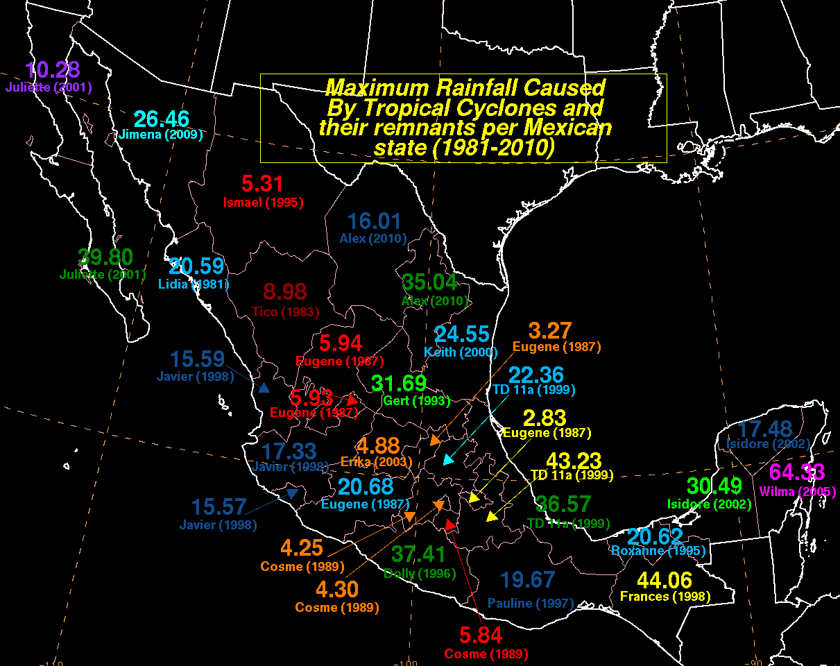
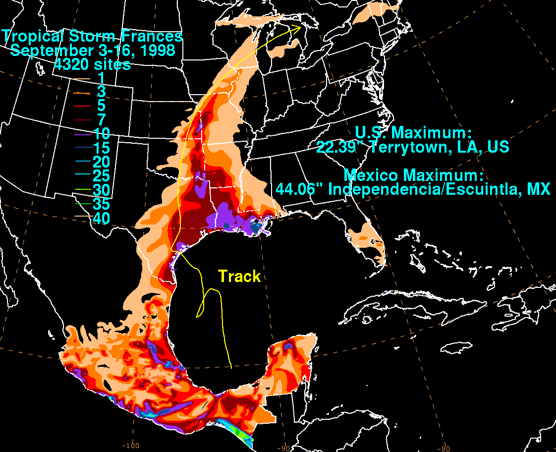
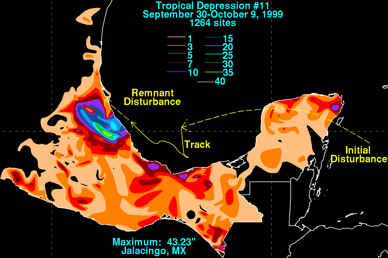
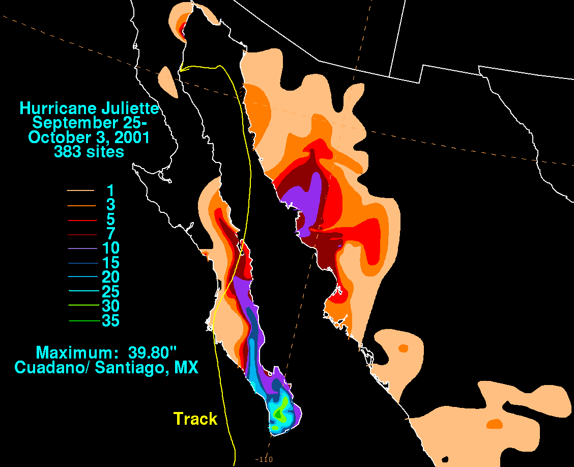
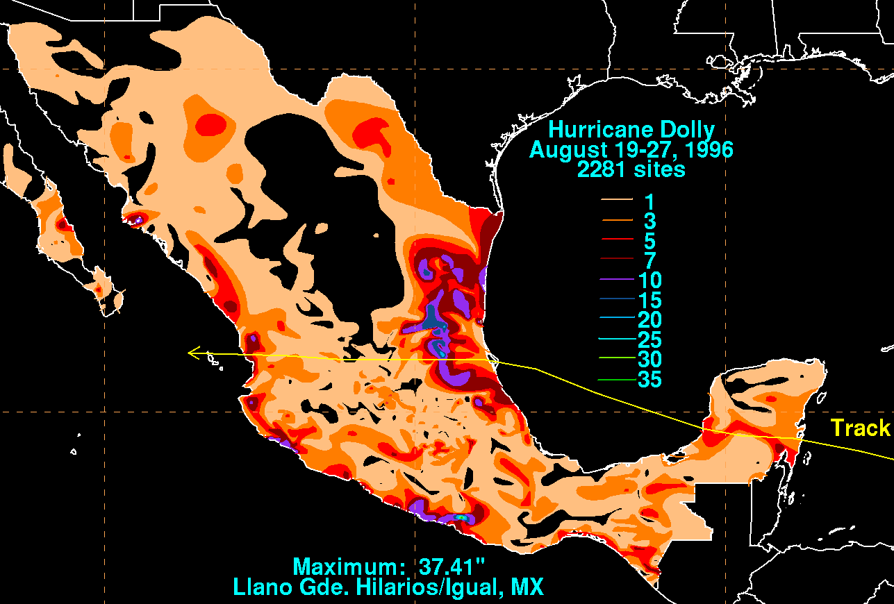
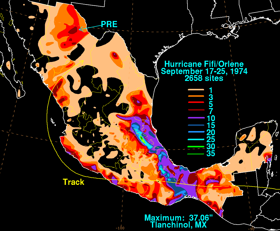
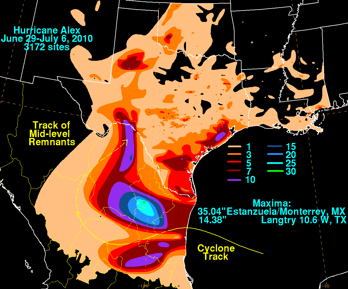
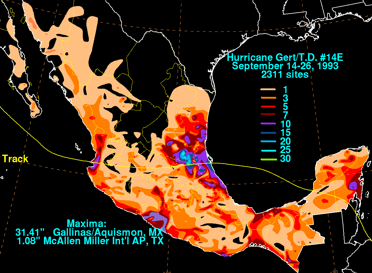
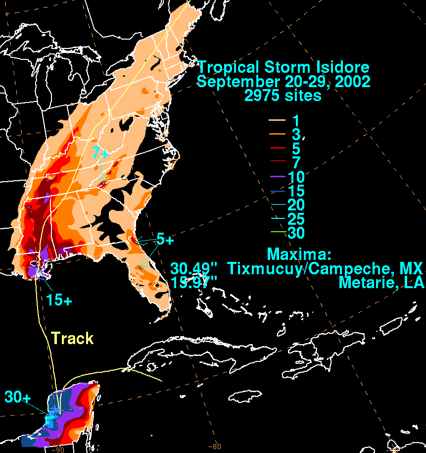
2005년의 허리케인 윌마는 유카탄 반도의 북동쪽 지역을 며칠 동안 떠내려가 큰 비를 내렸다. 멕시코의 세르비시오 마테오로지코 나시오날은 멕시코에서 측정된 24시간 강우량 중 가장 습도가 높은 1576밀리미터(62.0인치)의 보고서를 발표했다.[255] 2위는 1998년 치아파스 남부 인디펜던시아에 최고 1019밀리미터(40.1인치)의 비가 누적된 열대성 폭풍 프란체스코다.[256] 아래는 멕시코 전역의 개별 열대성 사이클론으로부터 가장 많이 알려진 폭풍우 총 강우량 목록이다. 강우 정보는 대부분 멕시코 국립기상청인 세르비시오 마테오로지코 나시오날 국립수자원위원회 소속인 코미시온 나시오날아구아과에서 제공됐다.

허리케인 윌마
가장 습한 열대성 사이클론 및 그 잔해 멕시코(전체)
가장 많이 알려진 총계
강수량 스톰 위치 Ref.
순위 mm in
1 1576 62.05 윌마 2005 퀸타나루오 [257]
2 1119 44.06 프랜시스 1998 에스쿠인틀라 [258]
3 1098 43.23 TD 11(1999년) 잘레이싱고 [259]
4 1011 39.80 줄리엣 2001 쿠아다노/산티아고 [260]
5 950 37.41 돌리 1996 이그알 [261]
6 941 37.06 피피-올린 1974년 틀란치놀 [262]
7 890 35.04 알렉스 2010 몬테레이 [263]
8 805 31.69 게르트 1993 아키스몬 [264]
9 791 31.15 헤르미네 1980 산페드로타파나테펙 [265]
10 774 30.49 이시도레 2002 캄페체 [266]

미크로네시아 연방

추욱

추크 석호를 둘러싼 섬들의 고도는 약 1450피트(440m)의 높이에 이른다.[267] 태풍 차타안은 총 939mm(37.0인치)가 내린 2002년 6월 23일부터 7월 3일까지 이 섬에 폭우를 몰고 왔다. 지난 1~3일부터 차타안이 열대저기압으로 선포된 기간 동안 국제공항에 2일 하루에만 506㎜(19.9인치)가 떨어지는 등 622㎜(24.5인치)가 떨어졌다.[268]

태풍 차타안
가장 습한 열대성 사이클로인과 그 잔해들은 추크에 있다.
가장 많이 알려진 총계
강수량 스톰 위치 Ref.
순위 mm in
1 939.0 36.96 차타안 2002 츄우크 국제공항 [269]
2 447.0 17.60 데일 1996 추욱 WSO AP [36]
3 427.5 16.83 2004년 수달 추욱 WSO AP [36]
4 405.1 15.95 앤디 1989 트룩 WSO 공항 [36]
5 381.1 15.03 1968년 장 트룩 WSO 공항 [36]
6 371.9 14.64 카렌 1962년 트룩 WSO 공항 [36]
7 370.6 14.59 파멜라 1976 트룩 WSO 공항 [36]
8 344.7 13.57 해리엇 1959 트룩 WSO 공항 [36]
9 234.2 9.22 쿨라프 2005 추욱 WSO AP [36]
10 214.1 8.43 2002년 퐁소나 추욱 WSO AP [36]

코스래

코스래 주의 가장 습한 열대성 사이클론 및 그 잔해
가장 많이 알려진 총계
강수량 스톰 위치 Ref.
순위 mm in
1 509.3 20.05 팩사이 2001 코스래 [36]
2 434.1 17.09 판폰 2002 코스래 [36]

폰페이 주

그 주는 열대 북서 태평양에 있는 산악 섬이다. 폰페이 주

폰페이 주의 가장 습한 열대성 사이클론 및 그 잔해
가장 많이 알려진 총계
강수량 스톰 위치 Ref.
순위 mm in
1 603 23.74 돌핀 2015 폰페이
2 247 9.72 악셀 1992 [270]
3 118 4.65 하이젠 2015 폰페이 [271]

야프 주

이 주에서 가장 습기가 많은 것으로 알려진 열대성 사이클론은 1982년 루비인데, 이 사이클론은 초기 개발 단계 동안 이 섬 근처에서 며칠 동안 표류했다.[272]

태풍 루비 (1982)
야프 주에서 가장 습한 열대성 사이클론 및 그 잔해
가장 많이 알려진 총계
강수량 스톰 위치 Ref.
순위 mm in
1 594.4 23.40 루비 1982 야프 섬 WSO 공항 [36]
2 390.9 15.39 임부도 2003 야프 섬 WSO 공항 [36]
3 318.5 12.54 위니 1969 야프 섬 WSO 공항 [36]
4 313.9 12.36 펀 1996 야프 섬 WSO 공항 [36]
5 301.8 11.88 와일라 1967 야프 섬 WSO 공항 [36]
6 289.1 11.38 오필리아 1958년 야프 섬 WSO 공항 [36]
7 288.5 11.36 호프 1985년 야프 섬 WSO 공항 [36]
8 250.2 9.85 조지아 1962년 야프 섬 WSO 공항 [36]
9 236.5 9.31 프란 1976년 야프 섬 WSO 공항 [36]
10 231.9 9.13 1963년 페이 야프 섬 WSO 공항 [36]

모잠비크

열대성 사이클론 엘라인

그 나라의 고도는 서쪽으로 증가하는데, 가장 높은 고원의 산들은 거의 8,000피트(2,400m)에 달한다.[273]

모잠비크의 가장 습한 열대성 사이클론 및 그 잔해
가장 많이 알려진 총계
강수량 스톰 위치 Ref.
순위 mm in
1 600 24.00 이다이 2019 치모이오
2 502 19.76 엘라인 2000 레부부 [274]
3 281 11.06 델피나 2003 [253]
4 200 7.87 조계 2008 남풀라 [275]
5 190 7.50 재펫 2003 [276]

미얀마

상륙 부근 사이클론 나르기스
미얀마의 가장 습한 열대성 사이클론 및 그 잔해
가장 많이 알려진 총계
강수량 스톰 위치 Ref.
순위 mm in
1 600 23.62 나르기스 2008 [277]
2 343.9 13.54 T.D. 2007년 2호 [278]
3 300 11.81 코멘 2015 [279]

네팔

이 행성에서 가장 높은 고도 중 일부는 네팔에 있다. 세계에서 가장 높은 14개의 봉우리 중 8개가 에베레스트(8848m)를 포함해 네팔 히말라야에 있다.[280] 2004년 인도 아대륙에 영향을 준 열대성 저기압 동안 카트만두 공항에는 10월 7일 1200 UTC로 끝나는 24시간 동안 51.3밀리미터(2.02인치)의 비가 내렸다.[76]

네덜란드령 안틸레스

사바

가장 습한 열대성 사이클로인과 사바에 남은 자들
가장 많이 알려진 총계
강수량 스톰 위치 Ref.
순위 mm in
1 286.3 mm 11.27인치 앨리스 (1954년) [281]

세인트유스타티우스

가장 습한 열대성 사이클론들과 그들의 잔해들이 성 위에 있다. 유스타티우스
가장 많이 알려진 총계
강수량 스톰 위치 Ref.
순위 mm in
1 203.2 mm 8.00인치 앨리스 (1954년) [281]

세인트마틴/신트마틴

이 구릉도는 부분적으로 프랑스 소유로 네덜란드 소유로 되어 있다.

허리케인 레니
가장 습한 열대성 사이클론 및 세인트 마틴/신트 마텐의 잔해
가장 많이 알려진 총계
강수량 스톰 위치 Ref.
순위 mm in
1 700.0 27.56 레니 1999 필립스버그 기상청 [2]
2 280.2 11.03 호세 1999 줄리아나 공주 국제공항 [282]
3 165.1 6.50 루이스 1995 [283]
4 111.7 4.40 오토 2010 줄리아나 공주 국제공항 [284]
5 92.3 3.63 라파엘 2012 줄리아나 공주 국제공항 [285]
6 7.9 0.31 에르네스토 2012 줄리아나 공주 국제공항 [285]
7 7.0 0.28 샹탈 2013 줄리아나 공주 국제공항 [286]
8 6.6 0.26 도리안 2013 . [286]

뉴질랜드

사이클론 볼라(1988)

뉴질랜드 근교를 지나는 열대성 사이클론은 대부분 열대변환(ET) 상태에 있거나 열대외가 되어 강우량 위협을 높일 수 있다.

뉴질랜드에서 가장 습한 열대성 사이클론 및 그 잔해
가장 많이 알려진 총계
수수량 스톰 위치 Ref.
순위 mm in
1 970 38.19 힐다 1990 노스 에그몬트 방문자 센터 [287]
2 917 36.10 볼라 1988 글렌로스 역 [288]
3 762 30.00 레와 1994 콜리어 크리크 [289]
4 425 16.73 퍼거스 1996 피너클스 [290][291]
5 415 16.34 들라일라 1989년 푸이푸히 [292]
6 321 12.64 디나 1967년 망아회 [293]
7 311 12.24 베티 1996 피너클스 [294]
8 306 12.05 [295]
9 290 11.42 아이비 2004 피너클스 [296]
10 280 11.02 윌마 2011 노스랜드 [297]

니카라과

허리케인 미치
및 그.
가장 많이 알려진 총계
수수량 스톰 위치 Ref.
순위 mm in
1 1597 62.87 미치 1998 피카초/치난데가 [298]
2 1447 56.97 알레타 1982 치난데가 [299]
3 674 26.55 에타 2020 푸에르토 코린토 [54]
4 500 19.69 조안 1988 [300]
5 447 17.60 게르트 1993 치난데가 [299]
6 368 14.49 피피 1974년 치난데가 [299]
7 298 11.72 2008년 알마 푼토산디노 [301]
8 272 10.70 세자르 1996 블루필드 [302]
9 231 9.10 아이다 2009 푸에르토 카베자스 [303]
10 181 7.11 펠릭스 2007 푸에르토 카베자스 [304]

니우에

사이클론 헤타

2004년 1월 열대성 사이클론 헤타가 지나는 동안 니우에 기상대는 24시간 내린 999.2밀리미터(39.34인치)의 기록적인 강우량을 보고했다.[305]

가장 습한 열대성 사이클론 및 니우에 잔해
가장 많이 알려진 총계
수수량 스톰 위치 Ref.
순위 mm in
1 999.2mm 39.34인치 헤타 2004 . [305]
2 107.5 mm 4인치23인치 01F 2014-15 [306]
3 101.8 mm 4.01인치 윈스턴 2016 [306]
4 77.6mm 3.06인치 티노 2015 [306]
5 28.4 mm 1.12인치 울라 2015 [306]
6 23.9mm 94인치 빅터 2016 [306]

오만

오만의 열대성 사이클론 및 그 잔해
가장 많이 알려진 총계
강수량 스톰 위치 Ref.
순위 mm in
1 617.0 24.29 메쿠누 2018 살랄라 [307]
2 610.0 24.02 고누 2007 [308]
3 488.0 19.21 펫 2010 자발힐름
4 482.4 18.99 마시라 사이클론 1977 살랄라 [309]
5 300.2 11.82 T.S. 02A(1996) 도파르 [310]
6 285.5 11.24 무스카트 사이클론 1890 무스카트 [309]
7 251.0 9.88 오만 사이클론 2002 카이룬 [311]
8 250.0 9.84 아쇼바 2015 마시라 섬 [312]
9 230.0 9.06 살랄라 사이클론 1963 살랄라 [309]
10 82.0 3.23 살랄라 사이클론 1959 살랄라 [309]

파키스탄

사이클론 펫, 2010년 6월 파키스탄에 깊은 우울증으로 상륙한 사이클론

아라비아해의 열대성 사이클론은 대개 파키스탄에 영향을 미친다. 벵골만에서 온 열대성 사이클론은 파키스탄 해안선에 도달할 때쯤에는 약해지지만 파키스탄에는 영향을 미칠 수 있다.[313]

파키스탄에서 가장 습한 열대성 사이클론 및 그 잔해
가장 많이 알려진 총계
강수량 스톰 위치 Ref.
순위 mm in
1 370 14.57 페트 (2010) 과다르 [314]
2 285 11.22 사이클론(1999년) 케티 반다르 [315]
3 245 9.64 BOB 03(2009) 카라치 [316][317][318]
4 191 7.51 BOB 06(2007) 카라치 [319][320][321]
5 145 5.71 온일(2004) 테타 [322]
6 110 3.94 예민(2007) 카라치
7 43 1.69 BOB 04(2007) 카라치 [323][324]
8 18 0.70 BOB 03(2009) 카라치 [325]

팔라우

태풍 마이크

팔라우는 험준하고 석호를 둘러싸고 있는 섬들로 이루어져 있다. 최고 2,060피트(630m)의 고도가 섬 그룹 내에 존재한다.[326]

Palau에서 가장 습한 열대성 사이클론 및 그 잔해
가장 많이 알려진 총계
강수량 스톰 위치 Ref.
순위 mm in
1 470.9 18.54 마리 1976년 코로르 [327]
2 293.1 11.54 1993년 나단 네크켄 임업 [36]
3 281.4 11.08 루비 1982 코로르 [36]
4 248.9 9.799 마이크 1990 코로르 [328]
5 121.7 4.79 다이앤무 2004 코로르 [329]
6 84.3 3.32 보파 2012 코로르 [330]
7 47.8 1.88 에위니아 2006 코로르 [331]

파나마

허리케인 미치의 남쪽으로 유입되면서 파나마에 인상적인 폭우가 쏟아졌다. 벨레데로 톨레는 1998년 10월 22일부터 31일까지 695밀리미터(27.4인치)의 강우량을 기록했다.

필리핀

태풍 파르마/페펑

이 필리핀 섬 군도는 루손에서 가장 높은 지형이 발견되는 상당히 산이 많다.

필리핀 섬에서 가장 습한 열대성 사이클론 및 잔해
가장 많이 알려진 총계
강수량 스톰 위치 Ref.
순위 mm in
1 2210.0 87.01 1911년 7월 사이클론 바기오 [332]
2 1854.3 73.00 페펑 (파르마) (2009) 바기오 [333]
3 1216.0 47.86 트리닝 (Carla) (1967) 바기오 [332]
4 1116.0 43.94 일량 (Zeb) (1998) 라 트리니다드, 벤게트 [334]
5 1085.8 42.74 페리아 (유토르)(2001) 바기오 [335]
6 1077.8 42.43 란도 (코푸) (2015) 바기오 [333]
7 1012.7 39.87 이그메 (민들레) (2004) [336]
8 902.0 35.51 단테 (쿠지라) (2009) [337]
9 879.9 34.64 1929년 9월 태풍 비라크, 카탄두아네스 [338]
10 869.6 34.24 오픈그 (Dinah) (1977년) 서부 루손 [339]

사모아

사이클론 튜니
가장 습한 열대성 사이클론 및 사모아의 잔해
가장 많이 알려진 총계
강수량 스톰 위치 Ref.
순위 mm in
1 508.2 20.01 튜니, 2015년 아피말루 [340]
2 470.5 18.52 울라, 2016년 아피말루 [340]
3 404.0 15.91 에반 2012 알라오아, 우폴루 [341]
4 382.4 15.06 아모스 2016 아피말루 [340]
5 320.0 12.60 기타, 2018년 르푸에 [342]
6 190.0 7.48 2014년 1월 살라니 [340]
7 171.8 6.76 2014년 5월 살라니 [340]
8 170.6 6.72 2015년 8월 레투이 [340]
9 169.5 6.67 2017년 12월 19층 레피우 [342]
10 138.4 5.45 2017년 9월 아피말루 [342]

싱가포르

2001년 12월 20일의 태풍 바메이는 섬 를 강타한 것으로 알려진 유일한 폭풍이었다. 165.1밀리미터(6.50인치)의 강우량이 줄었다.

솔로몬 제도

사이클론 이타
솔로몬 제도에서 가장 습한 열대성 사이클론 및 잔해
가장 많이 알려진 총계
강수량 스톰 위치 Ref.
순위 mm in
1 >2100 >82.68 나무 1986 과달카날 포포마나세우 [343]
2 >1000 >39.37 Ita 2014 골드 리지 광산 [344]
3 495 19.49 팸 2015 산타크루즈 섬 라타 [345]
4 305 12.01 안젤라 1966 과달카날 [346]
5 282 11.10 라켈 2015 서부문다 [347]

남아프리카 공화국

2000년 2월 열대성 사이클론 엘린에는 남아프리카 일부 지역에 많은 비가 내렸다. 가장 높은 양은 Thohoyandou에서 480mm(19인치)로 기록되었다.[348]

스페인

유럽 본토에 도달한 유일한 열대성 사이클론은 2005년 허리케인 빈스였다. 코르도바 인근 평원에 3.3인치(84mm)의 비가 내렸다.[349]

스리랑카

2004년 10월 초 열대성 저기압으로 스리랑카 전역에 폭우가 쏟아졌다. 지난 2일 0600 UTC로 종료된 24시간 동안 117.2mm(4.61인치)가 떨어진 갈레에서 최대치를 측정했다.[76]

세인트 브랜든, 남인도양

2003/2004년 섣달 그믐날의 열대 사이클론 다리우스는 섬의 서북서쪽으로 약 75마일을 지나갔다. 24시간 동안의 가장 가까운 접근 기간 동안의 강우량은 135mm(5.3인치)이었다.[350]

세인트키츠네비스

가장 습한 열대성 사이클론 및 세인트 키츠와 네비스의 잔해
가장 많이 알려진 총계
강수량 스톰 위치 Ref.
순위 mm in
1 153.7 6.05 앨리스 (1954년) [281]

타이완

대만의 산악 섬은 매년 평균 1.8개의 열대 저기압 상륙을 경험한다.[citation needed] 험준한 지형 때문에 대만은 열대성 사이클론, 특히 중앙 산맥에서 극도의 비가 내린다.

태풍 모라코트
대만에서 가장 습한 열대성 사이클론 및 그 잔해
가장 많이 알려진 총계
강수량 스톰 위치 Ref.
순위 mm in
1 3,060 120.47 모라코트 2009 알리산, 치에이 [351]
2 2,319 91.30 나리로2001번길 우라이, 뉴 타이베이 [352]
3 2,162 85.12 플로시 1969년 타이베이 베이토우 [351]
4 1,987 78.23 허브 1996 알리산, 치에이 [353]
5 1,774 69.84 사올라 2012 이롄 시 [354]
6 1,700 66.93 린 1987 타이페이 [355]
7 1,672 65.83 클라라 1967 동산, 이일란 [356]
8 1,611 63.43 신라쿠 2008 허핑, 타이중 [357]
9 1,561 61.46 아이탕 2005년 산디멘, 핑둥 [358]
10 1,546 60.87 2004년 에레 미올리 현 [359]

태국.

태풍 제케(1991)

열대성 사이클로인들은 가끔 북서 태평양에서 말레이 반도를 건너 벵골 만으로 간다.

태국에서 가장 습한 열대성 사이클론 및 그 잔해
가장 많이 알려진 총계
강수량 스톰 위치 Ref.
순위 mm in
1 493.8 19.44 제케 1991 크롱야이 [36]
2 470.0 18.50 틸다 1964 소마트에서 [360]
3 342.0 13.46 배 1952년 찬타부리 [360]
4 328.7 12.94 아이라 1990 롭 부리 [36]
5 322.6 12.70 1990년 에드 타쿠아파 [36]
6 279.5 11.00 18W(2013년) 무앙 구 [361]
7 273.6 10.77 프레드 1991 콘켄 [36]
8 257.3 10.13 브라이언 1989 타쿠아파 [36]
9 251.5 9.902 무이파 2004 프라하우프 키리칸 [362]
10 239.5 9.429 1990년 넬 고사무이 [36]

통가

사이클론 와카(2001)
통가의 열대성 사이클론 및 잔해
가장 많이 알려진 총계
강수량 스톰 위치 Ref.
순위 mm in
1 200.0 7.87 와카 2001
2 167.0 6.57 이름없는 1949년 누쿠알로파 [363]
3 153.0 6.02 2009년 2월 니와포우 [364]
4 152.2 6.00 믹 2010 푸아아모투
5 149.0 5.87 르네 2011 푸아아모투
6 120.0 4.72 아이작 1982 누쿠알로파 [365]
7 120.0 4.72 자스민 2012 통가타푸 [366]
8 97.7 3.85 바이아누 2006 푸아자모투 [367]
9 44.8 1.76 시릴 2011 바바우 [368]
10 37.5 1.48 윌마 2010 푸아아모투 [369]

영국

앵귈라

허리케인 호세 (1999년)
가장 습한 열대성 사이클로인과 그 잔해인 앙겔라
가장 많이 알려진 총계
강수량 스톰 위치 Ref.
순위 mm in
1 490.0 19.29 레니 1999 [370]
2 380.0 14.96 호세 1999 [370]
3 250.0 9.84 클라우스 1990 [370]
4 171.5 6.75 앨리스 1954 [281]

버뮤다

버뮤다는 역사적으로 열대성 사이클론으로부터 압도적인 비를 받은 적이 없다. 이것은 빠른 속도 폭풍이 보통 섬을 지나가고 섬에 산이 없기 때문일 수 있다.

허리케인 니콜(2016년)
버뮤다에서 가장 습한 열대성 사이클론 및 그 잔해
가장 많이 알려진 총계
강수량 스톰 위치 Ref.
순위 mm in
1 186.7 7.35 1939년 10월 허리케인 [371]
2 172.0 6.77 니콜 2016 [372]
3 153.7 6.05 알레네 1963 [36]
4 151.4 5.96 크리스토발 2002
5 148.0 5.83 니콜 2004
6 134.1 5.28 T.D. #23A 1967 [36]
7 126.2 4.97 프랭클린 2005
8 125.0 4.92 에밀리 1981 [36]
9 124.0 4.88 하비 2005
10 123.2 4.85 1948년 9월 허리케인 [371]

케이먼 제도

열대성 폭풍 알베르토
카이만 제도에서 가장 습한 열대성 사이클론 및 그 잔해
가장 많이 알려진 총계
강수량 스톰 위치 Ref.
순위 mm in
1 794.8 31.29 네이밍, 1944년 그랜드 케이먼 섬 [373]
2 577 22.72 2006년 알베르토 오언 로버츠 국제공항 [374]
3 552.2 21.74 이시도레 2002 케이맨 브라크 [375]
4 451.4 17.77 팔로마, 2008년 케이맨 브라크 [376]
5 308.4 12.14 이반 2004 그랜드 케이먼 섬 [377]
6 292.1 11.50 해티 1961 그랜드 케이먼 섬 [378]
7 250.7 9.87 에타 2020 그랜드 케이맨 [54]
8 229.1 9.02 니콜 2010 오언 로버츠 국제공항 [379]
9 165.6 6.52 미셸 2001 그랜드 케이먼 섬 [380]

미국

허리케인 하비(2017년)
미국에서 가장 습한 열대성 사이클론 및 그 잔해
가장 많이 알려진 총계
강수량 스톰 위치 Ref.
순위 mm in
1 1538.7 60.58 하비 2017 네덜랜드, 텍사스 [36]
2 1321 52.02 레인 2018 하와이 마운틴뷰 [381][382]
3 1321 52.00 히키 1950년 하와이 가날로훌루루 레인저 역 [383]
4 1219 48.00 아멜리아 1978 텍사스 주 메디나 [36]
5 1148 45.20 쉬운 1950년 양키타운, 플로리다 주 [36]
6 1143 45.00 클라우데트 1979 앨빈, 텍사스 주 [36]
7 1096 43.15 이멜다 2019 텍사스 제퍼슨 군 [384]
8 1058.7 41.68 T. D. 15 1970년 푸에르토리코 자유야 [36]
9 1033 40.68 앨리슨 2001 노스웨스트 제퍼슨 카운티, 텍사스 [36]
10 985 38.76 폴 2000 카파팔라 목장 36, 하와이 [385]

바누아투

사이클론 바니아(2011년)
바누아투의 열대성 사이클론 및 잔해
가장 많이 알려진 총계
강수량 스톰 위치 Ref.
순위 mm in
1 847.6 33.37 볼라 1988 라맵 [386]
2 545.0 21.46 다니 1999 바우어필드 공항 [387]
3 369.1 14.53 바니아 2011 아네티움 [388]
4 270.0 10.63 에릭 1985년 수루카비아, 펜테코스트 [389]
5 266.6 10.50 사라 1994 산토페코아 국제공항 [390]
6 254.4 10.02 아이비 2004 바우어필드 공항 [391]
7 247.6 9.748 안네 1988 산토페코아 국제공항 [390]
8 246.6 9.709 나이젤 1985년 산토페코아 국제공항 [390]
9 223.7 8.807 주만 1998 산토페코아 국제공항 [390]
10 219.3 8.634 esau 1992 산토페코아 국제공항 [390]

베네수엘라

몇몇 열대성 사이클론들이 최근 수십 년 동안 남아메리카의 북쪽 해안을 스쳐 지나갔다. 열대성 폭풍 브렛(1993)은 베네수엘라 포르투게사 구아나레에서 10시간 만에 339밀리미터(13.3인치)의 비가 내렸다.[392]

베트남

2009년 태풍 케타나로 촉발된 베트남 휴의 홍수
베트남에서 가장 습한 열대성 사이클론 및 그 잔해
가장 많이 알려진 총계
강수량 스톰 위치 Ref.
순위 mm in
1 1,773 69.8 2007년 파이파 남웅 [393]
2 1,691 66.6 오펠 2020 ỳ thng [394]
3 1,369 53.9 2007 흐엉허 [393]
4 1,239 48.8 2009년 9월 베트남 열대성 저기압 다낭 [395]
5 914 36.0 케타나 2009년 꽝남 [395]
6 788 31.0 레키마 2007 [393]
7 747 29.4 2016년 에레 ngi,,,,,,,,,? [396]
8 699 27.5 아이라 1990 [397]
9 666 26.2 미리나에 2009 반칸 [395]
10 550 21.7 샹산 2006년 [398]

참고 항목

참조

  1. ^ "Archived copy" (PDF). Archived from the original (PDF) on April 13, 2014. Retrieved April 11, 2014.{{cite web}}: CS1 maint: 타이틀로 보관된 사본(링크)
  2. ^ a b c Guiney, John L (December 9, 1999). Preliminary Report: Hurricane Lenny November 13 - 23, 1999 (PDF) (Report). United States National Hurricane Center. Retrieved April 25, 2016.
  3. ^ a b c d e f g h i "Antiguan Tropical Cyclones 1851 – 2016". Antigua and Barbuda Meteorological Service. July 4, 2017. Archived from the original on May 13, 2012. Retrieved January 25, 2018.
  4. ^ a b "Climate Education: Flood". Australian Bureau of Meteorology. Archived from the original on March 17, 2009. Retrieved January 18, 2011.
  5. ^ 기상국 퀸즐랜드의 열대성 사이클론. 2015년 7월 17일 회수
  6. ^ "Tropical Cyclone Fletcher Impacts". Bureau of Meteorology. Government of Australia. 2014. Retrieved March 5, 2014.
  7. ^ "Kowanyama, Queensland February 2014 Daily Weather Observations" (PDF). Bureau of Meteorology. Government of Australia. 2014. Archived from the original (PDF) on March 6, 2014. Retrieved March 6, 2014.
  8. ^ "Report on Severe Tropical Cyclone Aivu: Rainfall" (PDF). Bureau of Meteorology. Government of Australia. June 6, 1990. p. 17–18. Retrieved March 13, 2014.
  9. ^ "Tropical Cyclone May". Australian Bureau of Meteorology. 2013. Retrieved January 29, 2013.
  10. ^ Queensland Tropical Cyclone Warning Centre (2014). "Tropical Cyclone Justin" (PDF). Australian Bureau of Meteorology. Retrieved March 11, 2014.
  11. ^ "Tropical Cyclone Ellie". Australian Bureau of Meteorology. 2009. Retrieved January 27, 2013.
  12. ^ Williams, Brian; Michael, Peter (January 24, 2013). "Ex-cyclone Oswald heads south with heavy rain tipped for long weekend". The Courier Mail. Australian Associated Press. Archived from the original on January 24, 2013. Retrieved January 24, 2013.
  13. ^ http://www.bom.gov.au/announcements/sevwx/qld/qldtc20170325.shtml
  14. ^ a b c d e f "Tropical Cyclones Affecting the Cocos Islands and Christmas Island". Australian Bureau of Meteorology's Perth Tropical Cyclone Warning Centre. Archived from the original on July 22, 2012. Retrieved August 3, 2014.
  15. ^ Tropical Cyclone Dahlia (Report). Australian Bureau of Meteorology. Archived from the original on December 11, 2017. Retrieved December 11, 2017.
  16. ^ "Daily Rainfall at Christmas Island Aero (Updated at 20 November 2021)" (PDF). www.bom.gov.au. Melbourne, Victoria: Bureau of Meteorology. Archived from the original (PDF) on November 20, 2021. Retrieved November 20, 2021.
  17. ^ Severe Tropical Cyclone Gillian (Report). Australian Bureau of Meteorology. Archived from the original on August 3, 2014. Retrieved August 3, 2014.
  18. ^ Padgett, Gary. "Monthly Global Tropical Cyclone Summary: March 2007". Archived from the original on August 3, 2014. Retrieved August 3, 2014.
  19. ^ Tropical Cyclone Cecily December 11–19, 1973 (PDF) (Report). Australian Bureau of Meteorology. p. 2. Archived (PDF) from the original on August 10, 2014. Retrieved August 10, 2014.
  20. ^ Courtney, Joe (August 28, 2008). Tropical Cyclone Rosie, April 20–24, 2008 (PDF) (Report). Australian Bureau of Meteorology's Perth Tropical Cyclone Warning Centre. Archived (PDF) from the original on August 3, 2014. Retrieved April 9, 2014.
  21. ^ a b Tropical Cyclone Norah October 28 – November 4, 1974 (PDF) (Report). Australian Bureau of Meteorology. November 19, 2010. p. 2. Archived (PDF) from the original on December 3, 2015. Retrieved December 3, 2015.
  22. ^ Tropical Cyclone Denise: May 19 – 25, 1975 (PDF) (Report). Australian Bureau of Meteorology. November 19, 2010. p. 2. Archived (PDF) from the original on December 3, 2015. Retrieved December 3, 2015.
  23. ^ a b "Tropical Low 11U" (PDF). Australian Bureau of Meteorology's Western Australian Regional Office. March 2013. Archived (PDF) from the original on August 3, 2014. Retrieved August 3, 2014.
  24. ^ Perth Tropical Cyclone Warning Centre (June 12, 2009). Severe Tropical Cyclone Walter April 1 – 8, 2001 (PDF) (Individual Cyclone Reports). Australian Bureau of Meteorology. pp. 1–2. Archived (PDF) from the original on July 22, 2012. Retrieved July 22, 2012.
  25. ^ Severe Tropical Cyclone Tropical Cyclone Adeline 1 – 5 April 2005 (PDF) (Report). Australian Bureau of Meteorology's Perth Tropical Cyclone Warning Centre. November 19, 2010. pp. 1–2. Archived (PDF) from the original on August 3, 2014. Retrieved August 3, 2014.
  26. ^ Tropical Cyclone Deidre 20 – 25 December 1973 (PDF) (Report). Australian Bureau of Meteorology. p. 2. Archived (PDF) from the original on August 10, 2014. Retrieved August 10, 2014.
  27. ^ Western Australian Regional Office (2013). Severe Tropical Cyclone Bruce (Report). Australian Bureau of Meteorology. Archived from the original on January 11, 2015. Retrieved January 11, 2015.
  28. ^ "Cocos Island: December 2013 Daily Weather Observations". Australian Bureau of Meteorology. January 1, 2014. Archived from the original on January 11, 2015. Retrieved January 11, 2015.
  29. ^ Western Australian Regional Office (January 1, 2015). Severe Tropical Cyclone Kate (Report). Australian Bureau of Meteorology. Archived from the original on January 1, 2015. Retrieved January 1, 2015.
  30. ^ "Cocos Island: December 2014 Daily Weather Observations". Australian Bureau of Meteorology. January 1, 2015. Archived from the original on January 2, 2015. Retrieved January 1, 2015.
  31. ^ Tropical Cyclone Annie November 21, 1973 to December 8, 1973 (PDF) (Report). Australian Bureau of Meteorology's Perth Tropical Cyclone Warning Centre. August 13, 2009. p. 2. Archived from the original (PDF) on July 22, 2012. Retrieved August 10, 2014.
  32. ^ Tropical Cyclone Anggrek (Report). Australian Bureau of Meteorology's Western Australian Regional Office. 2010. p. 2. Archived from the original on August 10, 2014. Retrieved August 10, 2014.
  33. ^ Brown, Daniel P (December 17, 2007). Tropical Cyclone Report: Hurricane Noel (PDF) (Report). United States National Hurricane Center. p. 4. Retrieved April 25, 2016.
  34. ^ Avila, Lixion A; Stewart, Stacy R; Berg, Robbie; Hagen, Andrew B (April 20, 2020). Tropical Cyclone Report: Hurricane Dorian (PDF) (Report). United States National Hurricane Center. Retrieved April 28, 2020.{{cite report}}: CS1 maint : url-status (링크)
  35. ^ Stewart, Stacy R (April 3, 2017). Tropical Cyclone Report: Hurricane Matthew (PDF) (Report). United States National Hurricane Center. Retrieved April 6, 2017.{{cite report}}: CS1 maint : url-status (링크)
  36. ^ a b c d e f g h i j k l m n o p q r s t u v w x y z aa ab ac ad ae af ag ah ai aj ak al am an ao ap aq ar as at au av aw ax ay az ba bb bc bd be bf bg bh bi bj bk bl bm Roth, David M. (October 18, 2017). "Tropical Cyclone Point Maxima". Tropical Cyclone Rainfall Data. United States Weather Prediction Center. Retrieved November 26, 2017.
  37. ^ Beven III, John L (January 23, 2002). Tropical Cyclone Report: Hurricane Michelle (PDF) (Report). United States National Hurricane Center. Retrieved June 10, 2012.
  38. ^ Rappaport, Edward N (November 26, 1995). Preliminary Report: Hurricane Erin (PDF) (Report). United States National Hurricane Center. Retrieved June 10, 2012.
  39. ^ Beven III, John L; Stewart, Stacey R (February 8, 2009). Tropical Cyclone Report: Tropical Storm Fay 2008 (PDF) (Report). United States National Hurricane Center. Retrieved June 10, 2012.
  40. ^ Pasch, Richard J; Kimberlain, Todd B; Stewart, Stacey R (November 18, 1999). Preliminary Report: Hurricane Floyd (PDF) (Report). United States National Hurricane Center. Retrieved June 10, 2012.
  41. ^ Nick Wiltgen (July 31, 2015). "Tropical Cyclone Komen Soaking Waterlogged Bangladesh, Myanmar; At Least 33 Reported Dead, 6 Missing". The Weather Channel. Retrieved July 31, 2015.
  42. ^ "Bangladesh: Tropical Cyclone Rashmi" (PDF). World Food Program. United Nations. 2008. Archived from the original (PDF) on April 11, 2013. Retrieved March 30, 2010.
  43. ^ Padgett, Gary; Kevin Boyle; John Wallace; Huang Chunliang; Simon Clarke (May 17, 2005). "Monthly Global Tropical Cyclone Summary September 2004". Australian Severe Weather Index. Jimmy Deguara. Retrieved January 13, 2007.
  44. ^ "Crops on 1.28 lakh hectares land damaged". The Daily Star. May 18, 2013. Retrieved May 18, 2013.
  45. ^ Padgett, Gary; Kevin Boyle; John Wallace; Huang Chunliang; Simon Clarke (May 17, 2005). "Monthly Global Tropical Cyclone Summary October 2004". Retrieved January 13, 2007.
  46. ^ 1970 Annual Summary Part C — Storms & Depressions (PDF) (India Weather Review). India Meteorological Department. p. 10. Archived from the original on June 1, 2012. Retrieved June 1, 2012.
  47. ^ "Cyclone Sidr Rainfall Total". NASA. 2007. Retrieved June 15, 2009.
  48. ^ Staff Writer (2009). "Cyclone Aila Preliminary Report" (PDF). India Meteorological Department. Retrieved June 15, 2009.
  49. ^ Hal Pierce and Rob Gutro (April 20, 2009). "Hurricane Season 2009: Bijli (Northern Indian Ocean)". NASA. Retrieved May 23, 2009.
  50. ^ International Federation of Red Cross And Red Crescent Societies (2007). "Bangladesh: Cyclonic Storm Information Bulletin No. 01/2007". Retrieved May 17, 2007.
  51. ^ Biological-Diversity.info. 벨리즈의 생물학적 다양성. 2007년 2월 19일에 회수되었다.
  52. ^ Beven II, John L (January 29, 2001). Tropical Cyclone Report: Hurricane Keith: September 28 - October 6, 2000. National Hurricane Center (Technical report). National Oceanic and Atmospheric Administration. Archived from the original on July 29, 2014. Retrieved July 29, 2014.
  53. ^ Beven II, John L (January 29, 2001). Tropical Cyclone Report: Hurricane Keith: September 28 - October 6, 2000. National Hurricane Center (Technical report). National Oceanic and Atmospheric Administration. Archived from the original on July 29, 2014. Retrieved July 29, 2014.
  54. ^ a b c d e f g h 리처드 J. 패쉬와 데이비드 P. 로버츠(2021-06-09) 열대성 사이클론 보고서: 허리케인 Eta - 2020년 10월 31일-13일. 국립 허리케인 센터 2021년 6월 12일 회수되었다.
  55. ^ Brown, Daniel P (January 29, 2001). Tropical Cyclone Report: Tropical Depression Sixteen: October 14-15, 2008 (PDF). National Hurricane Center (Technical report). National Oceanic and Atmospheric Administration. p. 4. Archived from the original on July 29, 2014. Retrieved July 29, 2014.
  56. ^ a b 로비 버그(2020-09-10) 열대성 사이클론 보고서: 열대성 폭풍 아만다 - 2020년 5월 30-31일. 국립 허리케인 센터 2021년 6월 12일 회수되었다.
  57. ^ Franklin, James L (September 6, 2001). Tropical Cyclone Report: Tropical Storm Chantal: August 14 - 21, 2001. National Hurricane Center (Technical report). National Oceanic and Atmospheric Administration. Archived from the original on July 29, 2014. Retrieved July 29, 2014.
  58. ^ a b c 지질학 부록 목록 2007-04-08에 검색됨.
  59. ^ Hunting Caye Automatic Weather Station (1993). "Hourly Data during passage of Tropical Storm Gert". Retrieved December 21, 2008.
  60. ^ National Hurricane Center (1974). "Hurricane Fifi Preliminary Report Page 2". Retrieved December 21, 2008.
  61. ^ 1997년 캄보디아 콤팟에서 내린 일일 강우량. 2008-03-14년에 검색됨.
  62. ^ Hydrometeorological Branch of the Office of Hydrology of the United States Weather Bureau (May 1970). "Hydrometeorological Report Number 46: Probable Maximum Precipitation, Mekong River Basin" (PDF). United States Government Printing Office. pp. 142–145. Retrieved June 6, 2012.
  63. ^ 1998년 캄보디아 콤퐁 참에서 내린 일일 강우량. 2008-03-14년에 검색됨.
  64. ^ "1999-Harvey". Environment Canada. September 14, 2010. Retrieved September 14, 2011.
  65. ^ 환경캐나다. 캐나다 허리케인 센터: 허리케인의 영향. 2007-03-08에 검색됨.
  66. ^ "Hurricane Igor drenches Newfoundland peninsula". Toronto Star. September 21, 2010. Retrieved September 21, 2010.
  67. ^ CBC. [1] 2017-08-02년에 검색됨.
  68. ^ 환경캐나다. 허리케인 헤이즐 기억: 폭풍 정보. 2007-03-08에 검색됨.
  69. ^ 게리 패젯 월간 세계 열대 사이클론 요약: 2007년 7월. 2007-12-28에 검색됨.
  70. ^ 할 개리쉬 박사님 허리케인 버사 통계. 2007-03-08에 검색됨.
  71. ^ "2. Super Storm Sandy and Another Active Hurricane Season". Environment Canada. December 20, 2012. Retrieved December 24, 2012.
  72. ^ Canadian Hurricane Centre (2002). "2001 Tropical Cyclone Season Summary". Retrieved February 27, 2007.
  73. ^ 크리스 포가티와 피터 보우이어. 열대성 폭풍 크리스토발 정보 성명 2008년 7월 31일 발견
  74. ^ 크리스 포가티와 피터 보우이어. 2012-12-24년에 회수된 열대성 사이클론 레슬리 정보 성명.
  75. ^ 홍콩 천문대 날씨 사례: 2007년 6월 23일 태풍 이 회수되었다.
  76. ^ a b c Padgett, Gary; Kevin Boyle; John Wallace; Huang Chunliang; Simon Clarke (May 17, 2005). "Monthly Global Tropical Cyclone Summary October 2004". Retrieved January 13, 2007.
  77. ^ Meili, Cao (July 26, 2021). "余姚暴雨累计雨量达951毫米 相当于余姚近三天下了约37个西湖的水量". Sina News (in Chinese). Archived from the original on July 27, 2021. Retrieved July 27, 2021.
  78. ^ Padgett, Gary (December 27, 2006). "Monthly Global Tropical Cyclone Summary August 2001". Australian Severe Weather Index. Jimmy Deguara. Retrieved January 13, 2007.
  79. ^ "重要天气新闻通稿: 今年第13号 台风"苏迪罗"深入内陆影响结束" (in Chinese). National Meteorological Center. August 11, 2015. Archived from the original on August 11, 2015. Retrieved August 11, 2015.
  80. ^ Padgett, Gary; Kevin Boyle; John Wallace; Huang Chunliang; Simon Clarke (May 17, 2005). "Monthly Global Tropical Cyclone Summary August 2004". Australian Severe Weather Index. Jimmy Deguara. Retrieved January 13, 2007.
  81. ^ Mary Gilbert. "Chanthu to produce days of tropical rainfall, raise flood risk in South Korea and Japan". Accuweather. Archived from the original on September 17, 2021. Retrieved September 17, 2021.
  82. ^ "China: Floods — Information Bulletin no 2". International Federation of Red Cross and Red Crescent Societies. ReliefWeb. August 10, 2012. Retrieved August 10, 2012.
  83. ^ AIRcurrents. "AIR Post-Disaster Survey for Typhoon Chanchu Documents the Vulnerability of the Chinese Building Stock to Wind and Flood". Retrieved February 25, 2007.
  84. ^ a b c d e f g h i j Tropical Cyclones in 2010 (PDF) (Report). Hong Kong Observatory. p. 98. Retrieved May 14, 2012.
  85. ^ MSc. Gulliermo Vega G. (June 3, 2004). "Conferencia 1. Aspectos Hidrometeorologicos del Huracan Cesar" (PDF). p. 43. Archived from the original (PDF) on July 18, 2011. Retrieved November 7, 2009.
  86. ^ John L. Beven II and Robbie Berg (April 5, 2018). Tropical Cyclone Report: Hurricane Nate (PDF) (Report). Miami, Florida: National Hurricane Center. Retrieved April 12, 2018.
  87. ^ Naciones Unidas a Centroamérica (March 16, 1999). "Costa Rica: Evaluación de los Daños Ocasionados por el Huracán Mitch, 1998: Sus implicaciones para el desarrollo económico y social y el medio ambiente". United Nations. p. 10. {{cite web}}: 누락 또는 비어 있음 url= (도움말)
  88. ^ 다니엘 P. 브라운, 열대성 사이클론 보도: 열대성 폭풍 알마 2008년 11월 29일 검색됨
  89. ^ Fallas, Jorge; Valverde, Carmen (2005). "Evidence-based Policy for Integrated Control of Forested River Catchments in Extreme Rainfall and Snowmelt" (PDF). Epic-Force. p. 5. Retrieved October 8, 2011.[영구적 데드링크]
  90. ^ Brown, Daniel (2017). "Hurricane Otto" (PDF). NHC. p. 4. Retrieved June 18, 2017.
  91. ^ a b c d e f g h i j k Instituto Nacional de Recursos Hidráulicos (2012). "Lluvias intensas observadas y grandes inundaciones reportadas" (in Spanish). Archived from the original on November 5, 2013. Retrieved April 25, 2016.
  92. ^ WorldAtlas.com. 도미니카. 2007년 2월 19일에 회수되었다.
  93. ^ a b Gary Padgett (May 17, 2005). "Monthly Global Tropical Cyclone Summary September 2004". Retrieved January 13, 2007.
  94. ^ Fred L. Ogden (March 19, 2016). Indirect Peak Discharge Measurements on the Island of Dominica Associated with Extreme Rainfall from Tropical Storm Erika, August 27, 2015, with Modeling and Analysis (PDF) (Report). Government of Dominica. Retrieved March 21, 2017.
  95. ^ Richard J. Pasch; Andrew B. Penny & Robbie Berg (April 5, 2018). Hurricane Maria (AL152017) (PDF) (Report). Tropical Cyclone Report. National Hurricane Center. Retrieved April 9, 2018.
  96. ^ Paul J. Hebert (July 1, 1980). "Atlantic Hurricane Season of 1979" (PDF). Monthly Weather Review. American Meteorological Society. 108 (7): 973–990. Bibcode:1980MWRv..108..973H. doi:10.1175/1520-0493(1980)108<0973:AHSO>2.0.CO;2. Retrieved August 28, 2015.
  97. ^ "Preliminary Report on Hurricane Abby, July 10–15, 1960". National Hurricane Center. p. 1.
  98. ^ 도미니카 공화국 페이지. 도미니카 공화국 지리학 2007년 2월 19일에 회수되었다.
  99. ^ Brown, Daniel P (December 17, 2007). Tropical Cyclone Report: Hurricane Noel 2007 (PDF) (Technical report). United States National Hurricane Center. p. 4. Retrieved April 25, 2016.
  100. ^ (스페인어) "Lluvias dejan 3 muertos y 7.000 evacuados". Hoy. Periódico Hoy. Associated Press. August 5, 2011. Retrieved August 5, 2011.
  101. ^ (스페인어) Hugo del Jesus Segura Soto (July 18, 2005). "Inundaciones rápidas en la República Dominicana" (PDF). Centro de Estudios Hidrográficos. p. 57.
  102. ^ 볼레틴 클라이마톨로지코 멘수알: 셉티엠브레. 2007-03-09년에 검색됨.
  103. ^ 볼레틴 클라이마톨로지코 멘수알: 아고스토. 2007-03-09년에 검색됨.
  104. ^ 볼레틴 클라이마톨로지코 멘수알: 팔분의 일 2007-03-09년에 검색됨.
  105. ^ Brown, Daniel P; Kimberlain, Todd B; National Hurricane Center (March 27, 2009). Hurricane Hanna (PDF) (Tropical Cyclone Report). United States National Oceanic and Atmospheric Administration's National Weather Service. Retrieved June 1, 2012.
  106. ^ 볼레틴 클라이마톨로지코 멘수알: 메이요, 2007-03-09년에 회수됨
  107. ^ "Archived copy". Archived from the original on April 19, 2019. Retrieved September 6, 2018.{{cite web}}: CS1 maint: 타이틀로 보관된 사본(링크)
  108. ^ a b c d e "MARN - Depresión Tropical 12 e rompe récord histórico de lluvia acumulada".
  109. ^ [2]
  110. ^ WFP El Salvador Situation Report #2 - Tropical Storm Amanda (17 June 2020) (PDF) (Report). Reliefweb. World Food Programme. June 17, 2020. Retrieved August 24, 2020.
  111. ^ Staff Writer (May 30, 2010). "Agatha tocó tierra, pero las lluvias siguen hoy" (in Spanish). El Salvador.com. Archived from the original on May 30, 2010. Retrieved May 30, 2010.
  112. ^ Campbell, John R (1984). Dealing with disaster: hurricane response in Fiji. p. 55. Archived from the original (PDF) on July 23, 2014. Retrieved July 23, 2014.
  113. ^ Prasad, Rajendra (February 19, 1993). Tropical Cyclone Kina, December 26, 1992 – January 5, 1993 (Tropical Cyclone Report 92/1). Fiji Meteorological Service. Archived from the original (PDF) on October 26, 2013. Retrieved October 26, 2013.
  114. ^ Climate Services Division (January 10, 2017). Fiji Islands Climate Summary December 2016 Volume 33 Issue 12 (Report). Fiji Meteorological Service. Archived from the original (PDF) on January 17, 2017. Retrieved January 17, 2017.
  115. ^ Krishna, Ram (January 4, 1981). Publication No. 2: Tropical Cyclones in Fiji: November 1969 – April 1980 (Report). Fiji Meteorological Service. p. 3-5.
  116. ^ Fiji Islands Climate Summary January 2021 Volume 34 Issue 1 (PDF) (Report). Fiji Meteorological Service. February 8, 2021. Archived from the original (PDF) on February 8, 2021. Retrieved February 8, 2021.
  117. ^ Prasad, Rajendra (April 11, 1985). Preliminary Report: Tropical Cyclone Gavin (Report). Fiji Meteorological Service.
  118. ^ Terry, James P; Raj, Rishi (1999). "Island Environment and Landscape Responses to 1997 Tropical Cyclones in Fiji". Pacific Science. University of Hawai'i Press. 53 (3): 257–272. Retrieved January 4, 2013.
  119. ^ RSMC Nadi — Tropical Cyclone Centre (May 27, 1997). Preliminary Report on Tropical Cyclone "June" — May 3 - 5, 1997 (Report). Fiji Meteorological Service. Archived from the original (PDF) on March 21, 2014. Retrieved March 21, 2014.
  120. ^ Climate Services Division (January 7, 2013). Fiji Islands Climate Summary December 2012 (Report). Vol. 33. Fiji Meteorological Service. Archived from the original (PDF) on January 7, 2013. Retrieved January 8, 2013.
  121. ^ Climate Services Division (March 7, 2017). Fiji Islands Climate Summary February 2017 (Report). Vol. 38. Fiji Meteorological Service. Archived from the original (PDF) on July 1, 2017. Retrieved July 1, 2017.
  122. ^ Padgett, Gary. "Monthly Global Tropical Cyclone Summary December 1999". Archived from the original on April 1, 2012. Retrieved April 1, 2012.
  123. ^ Padgett, Gary (December 1, 2005). "Monthly Tropical Cyclone Summary — December 2004". Australian Severe Weather. Retrieved February 22, 2010.
  124. ^ http://horizon.documentation.ird.fr/exl-doc/pleins_textes/doc34-05/35797.pdf
  125. ^ Padgett, Gary (December 1, 1998). "Monthly Tropical Cyclone Summary — December 1997". Australian Severe Weather. Retrieved February 22, 2010.
  126. ^ Météo-France French Polynesia (June 24, 2008). Review of the 2006-07 and 2007-08 tropical cyclone seasons (Report). World Meteorological Organization. Retrieved February 22, 2010.
  127. ^ National Hurricane Center (1996). Hurricane Marilyn Preliminary Report (Report). National Hurricane Center. Retrieved February 14, 2007.
  128. ^ Guadelope 서비스 Régional de MIMETO-FRANS en Guadelope. 콤프테 렌두 운석학UE: Passion de l'Oouragan RENY du 17 au 19 novmbre 1999 sur l'archipel de la Guadelope. 2007-02-19년에 검색됨. a
  129. ^ Avila, Lixion A; National Hurricane Center (October 23, 1996). Hurricane Hortense 3-16 September 1996 (Preliminary Report). United States National Oceanic and Atmospheric Administration's National Weather Service. Archived from the original on July 3, 2013. Retrieved June 17, 2012.
  130. ^ 세계기상기구 과거 허리케인 시즌의 리뷰. 2007-02-24에 검색됨.
  131. ^ (프랑스어로) AFP, France Antilles (September 3, 2009). "07 - La Tempête tropicale Erika affecte la Guadeloupe". Catastrophes Naturalles. Retrieved September 4, 2009.
  132. ^ "PASSAGE DE L'OURAGAN EARL SUR LA GUADELOUPE Et LES ILES DU NORD" [PASSAGE OF THE HURRICANE EARL ON THE GUADELOUPE AND THE NORTH ISLANDS] (PDF). meteo.fr (in French). Retrieved December 15, 2017.
  133. ^ Perrusset, Marcell; Bouguen, Pierre (1970). La Tempête Tropicale Dorothy (Report) (in French). Météo-France. table 1 as archived by the National Hurricane Center in its Storm Wallet for Tropical Storm Dorothy, 1970. Retrieved January 24, 2012.
  134. ^ 1990 Klaus: Ouragan. Pluies extrêmes aux Antilles (Report) (in French). Météo-France. n.d. Retrieved September 6, 2015.
  135. ^ 1967 Beulah: Ouragan. Pluies extrêmes aux Antilles (Report) (in French). Météo-France. n.d. Retrieved September 6, 2015.
  136. ^ Rappaport, Edward N. (November 2, 2000). Hurricane Iris: 22 August–4 September 1995 (PDF) (Preliminary Report). 1995 Atlantic Hurricane Season. National Hurricane Center. Retrieved September 6, 2015. {{cite techreport}}: 외부 링크 위치 series= (도움말)
  137. ^ 1979 David: Ouragan. Pluies extrêmes aux Antilles (Report) (in French). Météo-France. n.d. Retrieved September 6, 2015.
  138. ^ Franklin, James L (January 31, 2008). Hurricane Dean (AL042007): August 13–23 2007 (PDF) (Technical report). National Hurricane Center. p. 4. Retrieved September 6, 2015.
  139. ^ Mayfield, Britt M (October 25, 1993). Tropical Storm Cindy: 14–17 August 1993 (Preliminary Report). Storm Wallet for Tropical Storm Cindy, 1993. National Hurricane Center. p. 2. Retrieved September 6, 2015. {{cite report}}: 외부 링크 위치 series= (도움말)
  140. ^ 1980 Allen: Ouragan. Pluies extrêmes aux Antilles (Report) (in French). Météo-France. n.d. Retrieved September 6, 2015.
  141. ^ Rappaport, Edward N (January 17, 1996). Hurricane Marilyn: September 12–22, 1995 (PDF) (Preliminary Report). 1995 Atlantic Hurricane Season. National Hurricane Center. Retrieved September 6, 2015. {{cite report}}: 외부 링크 위치 series= (도움말)
  142. ^ a b c d e f g h i "Cyclone Passes De 1880 à nos jours" (in French). Meteo France New Caledonia. Retrieved January 2, 2017.
  143. ^ http://www.meteo.nc/en-savoir-plus/accueil/actualites/484-cook-la-vie-du-phenomene-et-ses-consequences
  144. ^ Lyons, Steve (February 17, 2010). "La Reunion Island's Rainfall Dynasty!". The Weather Channel. Archived from the original on February 4, 2014. Retrieved February 4, 2014.
  145. ^ a b c d Quetelard, Hubert; Bessemoulin, Pierre; Cerveny, Randall S; Peterson, Thomas C; Burton, Andrew; Boodhoo, Yadowsun (2009). "Extreme Weather: World-Record Rainfalls During Tropical Cyclone Gamede". Bulletin of the American Meteorological Society. American Meteorological Society. 90 (5): 603–608. Bibcode:2009BAMS...90..603Q. doi:10.1175/2008BAMS2660.1.
  146. ^ a b c d e Landsea, Christopher W; Hurricane Research Division (March 12, 2007). "Subject: E4) What are the largest rainfalls associated with tropical cyclones?". Tropical Cyclone Frequently Asked Questions. Archived from the original on February 3, 2014. Retrieved April 12, 2013.
  147. ^ Précipitations extrêmes (Report). Meteo France. Retrieved April 15, 2013.
  148. ^ Padgett, Gary (December 27, 2006). "Monthly Global Tropical Cyclone Summary January 2002". Australian Severe Weather Index. Jimmy Deguara. Retrieved January 16, 2007.
  149. ^ "COMMUNIQUE". February 21, 2009. Archived from the original on February 21, 2009. Retrieved October 19, 2016.{{cite web}}: CS1 maint : bot : 원본 URL 상태 미상(링크)
  150. ^ Tropical Cyclone Florine 4–10 January. National Climatic Data Center (Report). Global tropical/extratropical cyclone climatic atlas. 1996. Retrieved November 20, 2016.
  151. ^ RSMC La Reunion (January 22, 2014). "Cyclone Tropical Bejisa (du 1 er au 3 janvier 2014)" (PDF) (in French). Meteo France. p. 1. Archived from the original (PDF) on February 21, 2014. Retrieved February 3, 2014.
  152. ^ Dominique MEKIES. Ingénieur des travaux de la météorologie. "WEBCMRS METEO-FRANCE / SAISONS CYLONIQUES". Retrieved October 19, 2016.
  153. ^ "COMMUNIQUE". February 10, 2008. Archived from the original on February 10, 2008. Retrieved October 19, 2016.{{cite web}}: CS1 maint : bot : 원본 URL 상태 미상(링크)
  154. ^ Pasch, Richard J; National Hurricane Center (November 22, 1999). Hurricane Jose: October 17 – 25, 1999 (Preliminary Report). United States National Oceanic and Atmospheric Administration's National Weather Service. Retrieved December 7, 2012.
  155. ^ Cangialosi, John P; National Hurricane Center (November 17, 2010). Hurricane Otto October 6–10 (PDF) (Tropical Cyclone Report). United States National Oceanic and Atmospheric Administration's National Weather Service. pp. 6–7. Retrieved December 7, 2012.
  156. ^ "Passage De L'ouragan Earl sur la Guadeloupe et Les Iles du north es 29 et 30 août 2010" (PDF) (in French). Météo-France. November 5, 2010. p. 5. Retrieved December 7, 2012.
  157. ^ Rappaport, Edward N; National Hurricane Center (January 17, 1996). Hurricane Marilyn: September 12 – 22, 1995 (Preliminary Report). United States National Oceanic and Atmospheric Administration's National Weather Service. Retrieved December 7, 2012.
  158. ^ a b c d e f g h i "Wallis and Futuna Cyclone Passes De 1880 à nos jours" [Wallis and Futuna Cyclone Passes From 1880 to the present day] (in French). Meteo France New Caledonia. Retrieved January 2, 2017.
  159. ^ "Cyclone Amos: les Samoa ravagées" [Cyclone Amos: ravaged Samoa]. Meteo (in French). Retrieved April 24, 2016.
  160. ^ "Death toll from storm Agatha rises in Central America". BBC News. May 31, 2010. Retrieved May 31, 2010.
  161. ^ Robert C. Bucknam; Jeffrey A. Coe; Manuel Mota Chavarria; Jonathan W. Godt; Arthur C. Tarr; Lee-Ann Bradley; Sharon A. Rafferty; Dean Hancock; Richard L. Dart; Margo L. Johnson (2001). "Landslides triggered by Hurricane Mitch in Guatemala − inventory and discussion". United States Geological Survey. Retrieved November 7, 2009.
  162. ^ http://www.insivumeh.gob.gt/meteorologia/agatha.pdf
  163. ^ Earth Observatory (September 22, 2008). "Hurricane Stan Floods Central America". National Aeronautics and Space Administration. Retrieved November 7, 2009.
  164. ^ Earth Observatory (May 25, 2005). "Tropical Storm Adrian May 16–21 Rainfall Totals". National Aeronautics and Space Administration. Archived from the original on February 13, 2010. Retrieved November 7, 2009.
  165. ^ Michigan Technological University Volcanoes Page (August 15, 1994). "Rainfall". Retrieved November 7, 2009.
  166. ^ Dardik, Alan, ed. (2016). Vascular Surgery: A Global Perspective. Springer. p. 341. ISBN 9783319337456.
  167. ^ Josh, Jagran, ed. (2016). "Current Affairs November 2016 eBook". p. 93.
  168. ^ 네이션스 백과사전. 아이티, 2007년 2월 19일 회수
  169. ^ Dunn, Gordon E; Moore, Paul L; Clark, Gilbert B; Frank, Neil L; Hill, Elbert C; Kraft, Raymond H; Sugg, Arnold L (1964). "The Hurricane Season of 1963" (PDF). Monthly Weather Review. American Meteorological Society. 92 (3): 136. Bibcode:1964MWRv...92..128D. doi:10.1175/1520-0493-92.3.128. ISSN 0027-0644. Archived (PDF) from the original on June 9, 2012. Retrieved May 13, 2012.
  170. ^ Brown, Daniel P (December 17, 2007). Tropical Cyclone Report: Hurricane Noel (PDF) (Report). United States National Hurricane Center. p. 4. Archived from the original on June 9, 2012. Retrieved June 1, 2012.
  171. ^ Stewart, Stacy R (April 3, 2017). Tropical Cyclone Report: Hurricane Matthew (PDF) (Report). United States National Hurricane Center. p. 4. Archived from the original on June 9, 2012. Retrieved April 6, 2017.
  172. ^ Finnigan, Sean (October 4, 2002). Hurricane Lili almost drowns Camp-Perin, Haiti (PDF) (Report). Organisation for the Rehabilitation of the Environment. p. 1. Archived from the original on June 9, 2012. Retrieved June 9, 2012.
  173. ^ Brown, Daniel P; Kimberlain, Todd B (March 27, 2009). Tropical Cyclone Report: Hurricane Hanna (PDF) (Report). United States National Hurricane Center. Archived from the original on June 9, 2012. Retrieved June 1, 2012.
  174. ^ Beven II, John L; Kimberlain, Todd B (January 22, 2009). Tropical Cyclone Report: Hurricane Gustav (PDF) (Report). United States National Hurricane Center. p. 4. Archived from the original on June 9, 2012. Retrieved June 1, 2012.
  175. ^ Jeff Masters and Bob Henson (August 24, 2020). "Laura expected to hit Gulf Coast as at least a Category 2 hurricane". Yale Climate Connections. Retrieved August 24, 2020.
  176. ^ 존 L. 기니와 마일스 B. 로렌스(2000-05-04) 허리케인 미치. 국립 허리케인 센터 2007년 2월 24일 회수되었다.
  177. ^ Arnold L. Sugg (March 1967). "The Hurricane Season of 1966" (PDF). Monthly Weather Review. National Oceanic and Atmospheric Administration. 95 (3): 131, 133, 135–6. doi:10.1175/1520-0493(1967)095<0131:thso>2.3.co;2. Retrieved February 10, 2012.
  178. ^ Consejo.Bz, Ltd. (2009). "Hurricane History of Belize". Retrieved November 7, 2009.
  179. ^ 리처드 J. 패쉬와 데이비드 P. 로버츠(2006-03-28) 열대성 사이클론 보고서: 허리케인 베타 - 2005년 10월 26-31일. 국립 허리케인 센터 2008년 11월 29일 회수되었다.
  180. ^ 댄 브라운(2008-11-19). 열대성 저기압 보고서 (2008년) 2008년 11월 26일 회수된 국립 허리케인 센터.
  181. ^ 스테이시 R. 스튜어트(2021-05-18). 열대성 사이클론 보고서: 허리케인 요타. 국립 허리케인 센터, 2021년 5월 29일 회수
  182. ^ 잭 베븐(2008-01-16). 열대성 사이클론 보고서: 허리케인 펠릭스. 국립 허리케인 센터 2008년 1월 18일 회수되었다.
  183. ^ Sosnowski, Alex (September 2, 2020). "Nana strikes Belize as hurricane with damaging winds, flooding rainfall". AccuWeather. Retrieved September 3, 2020.
  184. ^ Pasch, Richard J. (November 10, 1993). Preliminary Report Hurricane Gert: 14-21 September 1993 (Report). Hurricane Gert, Hurricane Wallet Digital Archives. Miami, Florida: National Hurricane Center. p. 3. Retrieved October 3, 2011.
  185. ^ http://docs.lib.noaa.gov/rescue/cd024_pdf/005ED280.pdf
  186. ^ Alarming Rise in the Number and Intensity of Extreme Point Rainfall Events over the Indian Region under Climate Change Scenario (PDF) (Report). Indian Institute of Tropical Meteorology. August 2009.
  187. ^ India Meteorological Department (1961). "Annual Summary — Storms & Depressions: Depression in the Bay of Bengal" (PDF). India Weather Review. National Oceanic and Atmospheric Administration: 10–11.
  188. ^ IMD. "IMD Pune Climate Bulletin Nov 2008" (PDF).
  189. ^ The Hindu (November 28, 2008). "Rain-related death toll rises to 51". Retrieved June 8, 2010.
  190. ^ Regional Specialized Meteorological Center New Delhi, India (January 2009). "Report on Cyclonic Disturbances over North Indian Ocean during 2008" (PDF). India Meteorological Department. Archived from the original on April 5, 2010. Retrieved January 17, 2013.
  191. ^ "Record Rainfall over Ketty Valley, Nilgiri, Tamil Nadu" (PDF). MAUSAM. IMD. 63 (1). January 2012.
  192. ^ M M Nayak (2007). "Cyclone Ogni". Andhra Pradesh Disaster Management. Retrieved June 8, 2010.
  193. ^ http://docs.lib.noaa.gov/rescue/cd019_pdf/00462691.pdf
  194. ^ India Meteorological Department (1963). "Annual Summary — Storms & Depressions: Deep depression in the Bay of Bengal" (PDF). India Weather Review. National Oceanic and Atmospheric Administration: 9–11. Retrieved May 13, 2013.
  195. ^ a b U.S.De, R.K.Dube and G.S.Prakasa Rao (July 2005). "Extreme Weather Events over India in the last 100 years" (PDF). J. Ind. Geophys. Union. 9 (3): 184. Retrieved June 8, 2010.
  196. ^ a b United Nations Office for the Coordination of Humanitarian Affairs (April 3, 2003). "Indonesia – Landslides OCHA Situation Report No. 1". ReliefWeb. Retrieved January 6, 2008.
  197. ^ Bureau of Meteorology Special Services Unit (2003). "Tropical Cyclone Inigo (March 30 – April 8)". Government of Australia. Archived from the original on August 27, 2006. Retrieved January 5, 2008.
  198. ^ Gary Padgett (2003). "April 2003 Worldwide Tropical Weather Summary". Retrieved January 5, 2008.
  199. ^ Padgett, Gary. "Monthly Global Tropical Cyclone Summary June 2007". Retrieved May 14, 2012.
  200. ^ 네이션스 백과사전. 자메이카. 2007년 2월 19일에 회수되었다.
  201. ^ Paulhaus, J. L. H. (1973). World Meteorological Organization Operational Hydrology Report No. 1: Manual For Estimation of Probable Maximum Precipitation. World Meteorological Organization. p. 178.
  202. ^ a b Evans, C. J.; Royal Meteorological Society (1975). "Heavy rainfall in Jamaica associated with Hurricane Flora 1963 and Tropical Storm Gilda 1973". Weather. Blackwell Publishing Ltd. 30 (5): 157–161. doi:10.1002/j.1477-8696.1975.tb03360.x. ISSN 1477-8696.
  203. ^ a b Ahmad, Rafi; Brown, Lawrence; Jamaica National Meteorological Service (January 10, 2006). "Assessment of Rainfall Characteristics and Landslide Hazards in Jamaica" (PDF). University of Wisconsin. pp. 24–27. Retrieved June 6, 2012.
  204. ^ Blake, Eric S.; National Hurricane Center (March 7, 2011). Tropical Storm Nicole (PDF) (Tropical Cyclone Report). United States National Oceanic and Atmospheric Administration's National Weather Service. Retrieved May 13, 2012.
  205. ^ Frank, Neil L.; Clark, Gilbert B. (1980). "Atlantic Tropical Systems of 1979". Monthly Weather Review. American Meteorological Society. 108 (7): 971. doi:10.1175/1520-0493(1980)108<0966:ATSO>2.0.CO;2. ISSN 0027-0644. Retrieved May 13, 2012.
  206. ^ Stewart, Stacey R.; National Hurricane Center (December 16, 2004). Hurricane Ivan (Tropical Cyclone Report). United States National Oceanic and Atmospheric Administration's National Weather Service. Retrieved May 13, 2012.
  207. ^ Blake, Eric S; Kimberlain, Todd B; Berg, Robert J; Cangialosi, John P; Beven II, John L (February 12, 2013). Hurricane Sandy: October 22 – 29, 2012 (PDF) (Tropical Cyclone Report). United States National Oceanic and Atmospheric Administration's National Weather Service. Archived from the original on February 17, 2013. Retrieved January 29, 2014.
  208. ^ a b Gonghui Wang; Akira Suemine; Gen Furuya; Masahiro Kaibori & Kyoji Sassa (2006). Rainstorm-induced landslides in Kisawa village, Tokushima Prefecture, Japan (PDF) (Report). International Association for Engineering Geology. Retrieved January 5, 2016.
  209. ^ a b Ikuo Tasaka (1981). "The Difference of Rainfall Distribution in Relation to Time-Scale: A Case Study on Heavy Rainfall of September 8–13, 1976, in the Shikoku Island Caused by Typhoon 7617 Fran" (PDF). Geographical Review of Japan (in Japanese). 54 (10): 570–578. doi:10.4157/grj.54.570. Retrieved January 5, 2016.
  210. ^ "Typhoon Talas". Japan Meteorological Agency. 2011. Retrieved September 6, 2011.
  211. ^ "Typhoons of the Western North Pacific, 1971". Climatological Data: National Summary. National Oceanic and Atmospheric Administration. 22 (1): 771. January 1971. Retrieved April 12, 2013.
  212. ^ "台風200514号 (Nabi) - 災害情報" (in Japanese). National Institute of Informatics. 2011. Retrieved December 31, 2011.
  213. ^ "台風199211号 (Kent) - 災害情報" (in Japanese). National Institute of Informatics. 2011. Retrieved December 31, 2011.
  214. ^ "アメダス日出岳(64211)@台風198911号" (in Japanese). National Institute of Informatics. 2011. Retrieved December 31, 2011.
  215. ^ "台風198305号 (Abby) - 災害情報" (in Japanese). National Institute of Informatics. 2011. Retrieved December 31, 2011.
  216. ^ "台風199019号 (Flo) - 災害情報" (in Japanese). National Institute of Informatics. 2011. Retrieved December 31, 2011.
  217. ^ "Annual Tropical Cyclone Report: Typhoon Trix" (PDF). Joint Typhoon Warning Center. United States Navy. 1972. pp. 183–192. Retrieved April 12, 2013.
  218. ^ http://agora.ex.nii.ac.jp/cgi-bin/dt/dsummary.pl?id=200813&basin=wnp&lang=en
  219. ^ J. L. H. Paulhaus (1973). World Meteorological Organization Operational Hydrology Report No. 1: Manual For Estimation of Probable Maximum Precipitation. World Meteorological Organization. p. 178.
  220. ^ Dave Ornauer (August 6, 2011). "USFJ-AFL division title games postponed (Updated)". Stars and Stripes. Retrieved August 6, 2011.
  221. ^ (일본어로) "【台風15号】国頭で総雨量535ミリ 大宜味床下浸水24件". 琉球新報. Yahoo! News. August 28, 2012. Retrieved August 29, 2012.
  222. ^ Padgett, Gary; Kevin Boyle; John Wallace; Huang Chunliang; Simon Clarke (May 17, 2005). "Monthly Global Tropical Cyclone Summary August 2002". Australian Severe Weather Index. Jimmy Deguara. Retrieved January 1, 2007.
  223. ^ (일본어로) "Rainfall from Typhoon Conson". National Institute of Informatics. 2004. Retrieved April 17, 2010.
  224. ^ Gary Padgett (June 12, 2003). "Monthly Tropical Cyclone Summary for April 2003". Typhoon 2000. Retrieved March 15, 2008.
  225. ^ a b Padgett, Gary; Kevin Boyle; John Wallace; Huang Chunliang; Simon Clarke (May 17, 2005). "Monthly Global Tropical Cyclone Summary August 2002". Australian Severe Weather Index. Jimmy Deguara. Retrieved January 13, 2007.
  226. ^ Padgett, Gary; Boyle, Kevin; Wallace, John; Chunliang, Huang; Clarke, Simon (May 17, 2005). "Monthly Global Tropical Cyclone Summary August 2004". Australian Severe Weather Index. Jimmy Deguara. Retrieved January 13, 2007.
  227. ^ "1972 Annual Tropical Cyclone Report" (PDF). Joint Typhoon Warning Center. p. 31. Retrieved April 6, 2014.
  228. ^ 합동태풍경보센터. 1972년 태풍연보: 부록 A. 2011년 6월 7일 2008년 10월 11일 회수된 웨이백 머신보관.
  229. ^ 김계환과 S.Y.. P1.3 한국 폭우에 대한 중국 남부의 열대 사이클론 역할 2007년 7월 1일에 검색됨.
  230. ^ "Super Typhoon Halong to Affect Korea This Week". The Chosunilbo. August 3, 2014. Retrieved August 3, 2014.
  231. ^ "태풍 '찬투'에 한라산 1300mm 폭우...제주 피해 속출 (사진)". 중앙일보 (in Korean). September 17, 2021. Archived from the original on September 17, 2021. Retrieved September 17, 2021.
  232. ^ South Korea Member Report (PDF) (Report). ESCAP/WMO Typhoon Committee 10th Integrated Workshop. 2015. Retrieved January 10, 2016.
  233. ^ 히데타카 지카모리. 2002년 강릉 남대강 유역의 태풍 루사(RUSA)로 인한 침수피해 분석 2007년 10월 1일, 2007년 2월 19일에 회수된 웨이백 머신보관.
  234. ^ LTJG Robert C. Weir (1982). "Typhoon Agnes (18)" (PDF). Annual Tropical Cyclone Report. Joint Typhoon Warning Center (Report). United States Navy. pp. 70–73. Retrieved September 11, 2014.
  235. ^ "Summary of Western North Pacific and North Indian Ocean Tropical Cyclones" (PDF). Joint Typhoon Warning Center. Archived from the original (PDF) on June 7, 2011. Retrieved March 12, 2007.
  236. ^ (한국어) http://www.newsis.com/ar_detail/view.html?ar_id=NISX20110808_0008916573&cID=10505&pID=10500
  237. ^ 알자지라. 태풍 나리가 한국을 강타하다. 2008년 3월 15일에 회수되었다.
  238. ^ 합동태풍경보센터 슈퍼 태풍 22W 사오마이. 2007년 3월 10일 회수된 웨이백 머신에 2011년 6월 7일 보관.
  239. ^ Kim Hee-jin (June 27, 2011). "2 rescuers, 4 others are swept away in typhoon". JoongAng Daily. ReliefWeb. Retrieved December 4, 2011.
  240. ^ 의회 도서관 국가 연구와 CIA 세계 팩트북. 마다가스카르 지형. 2007년 2월 19일에 회수되었다.
  241. ^ RSMC La Reunion Tropical Cyclone Centre. Cyclone Season 2001–2002 (Report). Météo-France. p. 91. Retrieved November 21, 2012.
  242. ^ Climate Prediction Center (2004). "Cyclone Elita (09S) Cumulative Track and rainfall" (PDF). United States National Weather Service, National Oceanic and Atmospheric Administration. Retrieved March 10, 2011.
  243. ^ Padgett, Gary (2002). "Monthly Global Tropical Cyclone Summary: February 2002". Archived from the original on November 21, 2012. Retrieved November 21, 2012.
  244. ^ a b Madagascar Direction de la Météorologie et de l'Hydrologie (September 5, 2008). "Madagascar: Review of the 2005/2006, 2006/2007 and 2007/2008 Cyclone Seasons". World Meteorological Organization. Retrieved September 23, 2012.
  245. ^ United States Agency for International Development (December 23, 2003). "Africa: Drought and floods hazards assessment December 23, 2003". Relief Web. Retrieved July 6, 2009.
  246. ^ "Tropical Storm Chanda Drenches Madagascar". Earthweek. January 13, 2012. Retrieved January 13, 2012.
  247. ^ a b Madagascar Direction de la Météorologie et de l'Hydrologie (2006). "Madagascar: Review of the 2003-04, 2004-05 Cyclone Seasons" (PDF). World Meteorological Organization. pp. 46–57. Retrieved September 23, 2010.
  248. ^ Madagascar Direction de la Météorologie et de l'Hydrologie (September 17, 2010). "Madagascar: Review of the 2008-09 & 2009-10 Cyclone Seasons". World Meteorological Organization. Retrieved September 23, 2010.
  249. ^ 게리 패젯 월간 세계 열대 사이클론 요약: 2006년 6월. 2007년 12월 28일 검색됨
  250. ^ Gary Padgett (December 27, 2006). "January, 2002". Monthly Global Tropical Cyclone Summary. Australian Severe Weather. Retrieved October 21, 2012.
  251. ^ http://www.meteo.fr/temps/domtom/La_Reunion/webcmrs9.0/anglais/archives/publications/saisons_cycloniques/index19981999.html p42
  252. ^ "Dumile: Plus de pluies que de dégâts" (in French). Le Mauricien. January 4, 2013. Retrieved February 14, 2013.
  253. ^ a b Padgett, Gary; John Wallace; Kevin Boyle; Simon Clarke (December 27, 2006). "Monthly Global Tropical Cyclone Summary December 2002". Australian Severe Weather Index. Jimmy Deguara. Retrieved January 13, 2007.
  254. ^ "Pacific ENSO Update: 2nd Quarter 2015" (PDF). 21 (2). United States Pacific El Niño-Southern Oscillation (ENSO) Applications Climate Center. May 29, 2015. Archived (PDF) from the original on March 19, 2016. Retrieved March 19, 2016. {{cite journal}}: Cite 저널은 필요로 한다. journal= (도움말)
  255. ^ 코미시온 나시오날 델 아구아 "윌마" 델 오케아노 아틀란티코: 2005년 10월 15일-25일. 2007년 6월 25일, 2007년 2월 19일에 회수된 웨이백 머신보관.
  256. ^ 수역학적 예측센터 2007년 1월 13일에 회수된 열대성 폭풍 프란체스코.
  257. ^ Roth, David M. "Maximum Rainfall Caused By Tropical Cyclones and their remnants per Mexican state (1981-2010)". Hydrometeorological Prediction Center: Tropical Cyclone Point Maxima. National Oceanic and Atmospheric Administration. Retrieved September 10, 2012.
  258. ^ Roth, David M. "Tropical Storm Frances (1998) Rainfall Graphic". Tropical Cyclone Point Maxima (GIF). Hydrometeorological Prediction Center. National Oceanic and Atmospheric Administration. Retrieved September 10, 2012.
  259. ^ Roth, David M. "Tropical Depression Eleven (1999) Rainfall Graphic". Tropical Cyclone Point Maxima (GIF). Hydrometeorological Prediction Center. National Oceanic and Atmospheric Administration. Retrieved September 10, 2012.
  260. ^ Roth, David M. "Hurricane Juliette (2001) Rainfall Graphic". Tropical Cyclone Point Maxima (GIF). Hydrometeorological Prediction Center. National Oceanic and Atmospheric Administration. Retrieved June 8, 2012.
  261. ^ Roth, David M. "Hurricane Dolly (1996) Rainfall Graphic". Tropical Cyclone Point Maxima (GIF). Hydrometeorological Prediction Center. National Oceanic and Atmospheric Administration. Retrieved September 10, 2012.
  262. ^ Roth, David M. "Hurricane Fifi/Orlene (1974) Rainfall Graphic". Tropical Cyclone Point Maxima (GIF). Hydrometeorological Prediction Center. National Oceanic and Atmospheric Administration. Retrieved September 10, 2012.
  263. ^ Roth, David M. "Hurricane Alex (2010) Rainfall Graphic". Tropical Cyclone Point Maxima (GIF). Hydrometeorological Prediction Center. National Oceanic and Atmospheric Administration. Retrieved September 10, 2012.
  264. ^ Roth, David M. "Hurricane Gert (1993) Rainfall Graphic". Tropical Cyclone Point Maxima (GIF). Hydrometeorological Prediction Center. National Oceanic and Atmospheric Administration. Retrieved September 10, 2012.
  265. ^ Roth, David M. "Tropical Storm Hermine (1980) Rainfall Graphic". Tropical Cyclone Point Maxima (GIF). Hydrometeorological Prediction Center. National Oceanic and Atmospheric Administration. Retrieved June 8, 2012.
  266. ^ Roth, David M. "Hurricane Isidore (2002) Rainfall Graphic". Tropical Cyclone Point Maxima (GIF). Hydrometeorological Prediction Center. National Oceanic and Atmospheric Administration. Retrieved September 10, 2012.
  267. ^ 콜로라도 주립 대학교 추욱(Truk) 석호의 지형. 2003년 8월 4일, 2007년 2월 19일에 회수된 웨이백 머신보관.
  268. ^ Padgett, Gary; John Wallace; Kevin Boyle (December 27, 2006). "Monthly Global Tropical Cyclone Summary: July 2002". Australian Severe Weather Index. Jimmy Deguara. Retrieved January 13, 2007.
  269. ^ Padgett, Gary. "Monthly Global Tropical Cyclone Summary: July 2002". Retrieved April 22, 2012.
  270. ^ 합동태풍경보센터 서북태평양 및 북인도양 열대성 사이클론 요약. 2007년 3월 12일 회수된 웨이백 머신에 2011년 6월 7일 보관.
  271. ^ "Storm Events Database: Guam: Tropical Storm Haishen". United States National Centers for Environmental Information. Retrieved July 9, 2016.
  272. ^ 합동태풍경보센터 태풍 루비. 2007년 1월 5일 회수된 웨이백 머신에 2011년 6월 6일 보관.
  273. ^ 네이션스 백과사전. 모잠비크의 2007년 2월 19일에 회수되었다.
  274. ^ 남아프리카 기상청. 열대성 사이클론 엘라인: 2000년 2월. 2007년 2월 19일에 회수되었다.
  275. ^ 남아프리카 기상청. 열대성 사이클론 '조크위'는 북부 모잠비크에 허리케인 '강우'를 몰고 온다. 2008년 6월 16일 회수된 웨이백 머신에 2008년 3월 14일 보관.
  276. ^ 국립 기후 데이터 센터. 2003년 3월의 기후. 2007년 12월 29일에 회수되었다.
  277. ^ NASA (May 4, 2008). "Cyclone Nargis". Earth Observatory. Archived from the original on March 16, 2010. Retrieved November 7, 2009.
  278. ^ "Heavy rains kill five in Myanmar's main city". Reuters. Retrieved March 24, 2008.
  279. ^ http://www.rsmcnewdelhi.imd.gov.in/images/pdf/publications/preliminary-report/KOM.pdf
  280. ^ 국가 온라인. [3] 2011년 10월 20일에 회수함.
  281. ^ a b c d Colón José A (January 1956). "On the formation of Hurricane Alice, 1955 with notes on other cold-season tropical storms" (PDF). Monthly Weather Review. 84 (1): 1–14. Bibcode:1956MWRv...84....1C. doi:10.1175/1520-0493(1956)084<0001:OTFOHA>2.0.CO;2.
  282. ^ Pasch, Richard J; National Hurricane Center (November 22, 1999). Hurricane Jose: October 17 - 25, 1999 (Preliminary Report). United States National Oceanic and Atmospheric Administration's National Weather Service. Retrieved December 7, 2012.
  283. ^ Lawrence, Miles B; National Hurricane Center (January 8, 1996). Hurricane Luis: August 27 - September 11, 1995 (Preliminary Report). United States National Oceanic and Atmospheric Administration's National Weather Service. Retrieved December 7, 2012.
  284. ^ Cangialosi, John P; National Hurricane Center (November 17, 2010). Hurricane Otto October 6 - 10 (PDF) (Tropical Cyclone Report). United States National Oceanic and Atmospheric Administration's National Weather Service. p. 6-7. Retrieved December 7, 2012.
  285. ^ a b Connor, Desiree; Etienne-LeBlanc, Sheryl (January 2013). Climatological Summary 2012 (PDF) (Report). Meteorological Department St. Maarten. p. 10. Archived from the original on February 5, 2014. Retrieved December 7, 2012.
  286. ^ a b 2013 Atlantic Hurricane Season Summary Chart (PDF) (Report). Meteorological Department St. Maarten. January 2013. Archived from the original on February 5, 2014. Retrieved February 5, 2013.
  287. ^ March 1990 North Island Ex-tropical Cyclone Hilda (NZ Historic Weather Events Catalog). National Institute of Water and Atmospheric Research. November 7, 2013. Archived from the original on February 4, 2014. Retrieved February 4, 2014.
  288. ^ March 1988 North Island Ex-tropical Cyclone Bola (NZ Historic Weather Events Catalog). National Institute of Water and Atmospheric Research. November 7, 2013. Archived from the original on February 4, 2014. Retrieved February 4, 2014.
  289. ^ January 1994 South Island Ex-tropical Cyclone Rewa (NZ Historic Weather Events Catalog). National Institute of Water and Atmospheric Research. November 7, 2013. Archived from the original on February 4, 2014. Retrieved February 4, 2014.
  290. ^ December 1996 Upper North Island Ex-tropical Cyclone Fergus (NZ Historic Weather Events Catalog). National Institute of Water and Atmospheric Research. November 7, 2013. Archived from the original on February 4, 2014. Retrieved February 4, 2014.
  291. ^ McGavin, Trevor. Cyclone Fergus: 29–31 December 1996 (Report). Meteorological Service of New Zealand Limited. Archived from the original on May 25, 2015. Retrieved May 24, 2015.
  292. ^ January 1989 Northland Cyclone Delilah (NZ Historic Weather Events Catalog). National Institute of Water and Atmospheric Research. November 7, 2013. Archived from the original on February 4, 2014. Retrieved February 4, 2014.
  293. ^ February 1967 North Island Ex-tropical Cyclone Dinah (NZ Historic Weather Events Catalog). National Institute of Water and Atmospheric Research. November 7, 2013. Archived from the original on February 4, 2014. Retrieved February 4, 2014.
  294. ^ March 1996 Eastern North Island Ex-Tropical Cyclone Beti (NZ Historic Weather Events Catalog). National Institute of Water and Atmospheric Research. November 7, 2013. Archived from the original on February 4, 2014. Retrieved February 4, 2014.
  295. ^ April 1968 New Zealand Ex-tropical Cyclone Giselle (NZ Historic Weather Events Catalog). National Institute of Water and Atmospheric Research. November 7, 2013. Archived from the original on February 4, 2014. Retrieved February 4, 2014.
  296. ^ February–March 2004 North Island Ex-tropical Cyclone Ivy (NZ Historic Weather Events Catalog). National Institute of Water and Atmospheric Research. November 7, 2013. Archived from the original on February 4, 2014. Retrieved February 4, 2014.
  297. ^ January 2011 Upper North Island Storm (NZ Historic Weather Events Catalog). National Institute of Water and Atmospheric Research. November 7, 2013. Archived from the original on February 4, 2014. Retrieved February 4, 2014.
  298. ^ U. S. Geological Survey. "Landslide Response to Hurricane Mitch Rainfall in Seven Study Areas in Nicaragua" (PDF). Retrieved February 19, 2007.
  299. ^ a b c Dr. Wilfried Strauch (November 2004). "Evaluación de las Amenazas Geológicas e Hidrometeorológicas para Sitios de Urbanización" (PDF). Instituto Nicaragüense de Estudios Territoriales (INETER). p. 11. Retrieved November 7, 2009.
  300. ^ "Nicaragua - Hurricane Joan". ReliefWeb. October 26, 1988. Retrieved November 7, 2009.
  301. ^ Daniel P. Brown. "Tropical Cyclone Report: Tropical Storm Alma" (PDF). National Hurricane Center. Retrieved November 29, 2008.
  302. ^ Lixion Avila. "Preliminary Report: Hurricane Cesar - 24-29 July 1996" (PDF). National Hurricane Center. Retrieved November 29, 2008.
  303. ^ Lixion A. Avila and John Cangialosi (January 14, 2010). "Tropical Cyclone Report: Hurricane Ida" (PDF). National Hurricane Center. Retrieved January 14, 2010.
  304. ^ Jack Beven. "Tropical Cyclone Report: Hurricane Felix" (PDF). National Hurricane Center. Retrieved January 18, 2008.
  305. ^ a b Padgett, Gary (2004). "Monthly Global Tropical Cyclone Summary: January 2004". Retrieved April 25, 2016.
  306. ^ a b c d e Niue Country Report: Tropical Cyclone Season 2014-2015 & 2015–2016 (PDF). RA V Tropical Cyclone Committee for the South Pacific and the South-East Indian Ocean Sixteenth Session. 2016. Archived from the original (PDF) on July 2, 2017. Retrieved December 9, 2020.
  307. ^ "Salalah gets over 5 years of Oman's average annual rain". Times of Oman. May 27, 2018. Retrieved May 27, 2018.
  308. ^ El Rafy, Mostafa; Hafez, Yehia (April 23, 2008). Anomalies in meteorological fields over northern Asia and it's [sic] impact on Hurricane Gonu (PDF). 28th Conference on Hurricanes and Tropical Meteorology. American Meteorological Society. Archived from the original (PDF) on June 9, 2011. Retrieved June 6, 2012.
  309. ^ a b c d Membery, David (July 2002). "Monsoon Tropical Cyclones: Part 2". Weather. Royal Meteorological Society. 57 (7): 249–255. Bibcode:2002Wthr...57..246M. doi:10.1256/004316502760195911.
  310. ^ Membery, David (April 1998). "Famous for 15 minutes: An investigation into the causes and effects of the tropical storm which struck southern Arabia in June 1996". Weather. Royal Meteorological Society. 53 (4): 106–110. Bibcode:1998Wthr...53..102M. doi:10.1002/j.1477-8696.1998.tb03972.x.
  311. ^ Economic and Social Commission for Asia and the Pacific (March 10, 2003). "2002 Annual Tropical Cyclones Review" (PDF). World Meteorological Organization. p. 52. Retrieved July 15, 2008.
  312. ^ Fahad Al Mukrashi (June 12, 2015). "Heavy rains cause flooding in southern Oman". Gulf News. Muscat, Oman. Retrieved June 12, 2015.
  313. ^ "Detailed history of Cyclones in Pakistan". March 31, 2011. Retrieved October 19, 2016.
  314. ^ http://www.centralasiaonline.com/cocoon/caii/xhtml/en_GB/newsbriefs/caii/newsbriefs/2010/06/04/newsbrief-04
  315. ^ "The Heat Is Online". Retrieved October 19, 2016.
  316. ^ "Archived copy" (PDF). Archived from the original (PDF) on August 6, 2010. Retrieved January 10, 2011.{{cite web}}: CS1 maint: 타이틀로 보관된 사본(링크)
  317. ^ "Weather History for Karachi, Pakistan - Weather Underground". Retrieved October 19, 2016.
  318. ^ "Effects of Heavy Rain in Karachi on 18 July 2009". Retrieved October 19, 2016.
  319. ^ "World Weather - AccuWeather.com". Retrieved October 19, 2016.
  320. ^ https://www.webcitation.org/5QwDsh3rS?url=http:///www.pakmet.com.pk/monsoon.html
  321. ^ Bhagwandas (August 12, 2007). "KARACHI: 191mm [sic] rain in two days leaves city in shambles". Retrieved October 19, 2016.
  322. ^ http://archives.dawn.com/dawnftp/72.249.57.55/dawnftp/fixed/arch/arch_2004/arch_oct_04.htm
  323. ^ https://www.webcitation.org/5Q0T8juTq?url=http:///www.pakmet.com.pk/sindhadvisory.html
  324. ^ Siddiqui, Tahir (July 1, 2007). "KARACHI: Rains pile on the misery". Retrieved October 19, 2016.
  325. ^ http://news.dawn.com/wps/wcm/connect/dawn-content-library/dawn/the-newspaper/local/karachi-heavy-rains-forecast-579[영구적 데드링크]
  326. ^ 네이션스 백과사전. 팔라우 2007년 2월 25일에 회수되었다.
  327. ^ 합동태풍경보센터 PALAU에 영향을 미치는 열대성 사이클론. 2007년 2월 25일에 회수되었다.
  328. ^ Joint Typhoon Warning Center (1991). "Northwest Pacific and North Indian Ocean Tropical Cyclones of 1990" (PDF). United States Navy. Archived from the original (PDF) on February 27, 2008. Retrieved March 12, 2007.
  329. ^ Padgett, Gary. "Monthly Global Tropical Cyclone Summary June 2004". Retrieved January 13, 2007.
  330. ^ National Weather Service Office in Guam (2013). Palau Event Report: Hurricane. National Climatic Data Center (Report). National Oceanic and Atmospheric Administration. Retrieved August 3, 2015.
  331. ^ National Weather Service (Tiyan, Guam) (July 9, 2006). "PRELIMINARY POST-STORM REPORT...TROPICAL STORM EWINIAR (04W)". National Oceanic and Atmospheric Administration. Archived from the original on August 21, 2006. Retrieved August 7, 2006.
  332. ^ a b J. L. H. Paulhaus (1973). World Meteorological Organization Operational Hydrology Report No. 1: Manual For Estimation of Probable Maximum Precipitation. World Meteorological Organization. p. 178.
  333. ^ a b Nick Wiltgen (October 21, 2015). "Former Super Typhoon Koppu (Lando) Weakens to Remnant Low over Northern Philippines". The Weather Channel. Retrieved October 21, 2015.
  334. ^ Guillermo Q. Tabios III; David S. Rojas Jr. Rainfall Duration-Frequency Curve for Ungaged Sites in the High Rainfall, Benguet Mountain Region in the Philippines (PDF) (Report). Kyoto University. Retrieved June 2, 2015.
  335. ^ 레옹시오 A. 아마도어 박사님 필리핀의 극심한 기후변화에 따른 사회경제적 영향 2007년 2월 25일에 회수되었다.
  336. ^ Padgett, Gary; Kevin Boyle; John Wallace; Huang Chunliang; Simon Clarke (October 26, 2006). "Monthly Global Tropical Cyclone Summary June 2004". Australian Severe Weather Index. Jimmy Deguara. Retrieved January 13, 2007.
  337. ^ Steve Lang (May 7, 2009). "Hurricane Season 2009: Kujira (Western Pacific Ocean)". NASA. Retrieved December 23, 2011.
  338. ^ Coronas, José (September 1929). "Typhoons and Depressions – a Destructive Typhoon Over Southern and Central Luzon on September 2 and 3, 1929" (PDF). Monthly Weather Review. American Meteorological Society. Weather Bureau. 57 (9): 398–399. Bibcode:1929MWRv...57..398C. doi:10.1175/1520-0493(1929)57<398b:TADDTO>2.0.CO;2. Retrieved September 26, 2015.
  339. ^ Narciso O. Itoralba (December 1981). Annual Tropical Cyclone Report 1977. Philippine Atmospheric, Geophysical and Astronomical Services Administration. p. 65.
  340. ^ a b c d e f "2014-2015 & 2015 - 2016 Seasonal Review" (PDF). Samoa Meteorological Division. September 12, 2016.
  341. ^ Jones, Rick; Ready, Steve (August 17, 2013). A Case Study of Tropical Cyclone Evan around Samoa (Report). World Meteorological Organization. Retrieved December 10, 2013.
  342. ^ a b c "Review of the 2016/2017 and 2017/2018 Cyclone Seasons" (PDF). Samoa Meteorological Division. October 12, 2018.
  343. ^ Danitofea, S; Baines, Graham B.K (October 1987). Cyclone "Namu" and the North Guadalcanal Coast, Solomon Islands: Implications for Economic Development. Workshop on Coastal Processes in the South Pacific Island Nations October 1–7, 1987. Retrieved April 25, 2016.
  344. ^ "Future of Gold Ridge Mining Uncertain After Floods". Solomon Times Online. April 10, 2014. Retrieved April 25, 2016.
  345. ^ http://www.wmo.int/pages/prog/www/tcp/documents/RAV_TCC-16_SolomonIslands_CountryReport_Document.pdf
  346. ^ Radford, Deirdre A; Blong, Russell J (1992). Natural Disasters in the Solomon Islands (PDF). Vol. 1 (2 ed.). The Australian International Development Assistance Bureau. pp. 125–126. Archived from the original (PDF) on July 6, 2013. Retrieved April 25, 2016.
  347. ^ Tropical Cyclone Raquel (Report). Australian Bureau of Meteorology. 2015. Archived from the original on September 10, 2015. Retrieved April 25, 2016.
  348. ^ "Tropical Cyclone Eline: February 2000". South African Weather Service. 2003. Archived from the original on July 20, 2009. Retrieved September 11, 2015.
  349. ^ James Franklin (February 22, 2006). "Tropical Cyclone Report Hurricane Vince" (PDF). National Hurricane Center. p. 2. Retrieved May 7, 2008.
  350. ^ Padgett, Gary; Kevin Boyle; Simon Clarke (October 26, 2006). "Monthly Global Tropical Cyclone Summary: December 2003". Australian Severe Weather Index. Jimmy Deguara. Retrieved January 19, 2007.
  351. ^ a b Central Weather Bureau (2010). "侵台颱風資料庫". Retrieved October 19, 2011.
  352. ^ Unattributed (September 9, 2009). "莫拉克颱風暴雨量及洪流量分析" (PDF). Water Resources Agency, Ministry of Economic Affairs, Republic of China. Retrieved July 17, 2011.
  353. ^ Unattributed (September 9, 2009). "莫拉克颱風暴雨量及洪流量分析" (PDF). Water Resources Agency, Ministry of Economic Affairs, Republic of China. Retrieved July 17, 2011.
  354. ^ Chen Zhi (August 2, 2012). "Typhoon Saola dumps heavy downpours around Taiwan". Xinhua General News. Retrieved August 2, 2012.
  355. ^ Joint Typhoon Warning Center; Naval Pacific Meteorology and Oceanography Center (1988). Annual Tropical Cyclone Report: 1987 (PDF) (Report). United States Navy, United States Air Force. Retrieved July 1, 2014.
  356. ^ Lianshou, Chen. Topic 2.1 Observing and forecasting rainfall. Fifth International Workshop on Tropical Cyclones. Retrieved August 4, 2012.
  357. ^ "Typhoon Sinlaku Central emergency operation center No.12". Central emergency operation center. September 16, 2008. Retrieved January 13, 2009.
  358. ^ Chiu Yu-Tzu (July 20, 2005). "Haitang fizzles out, leaves Taiwan wet". Taipei Times. Retrieved April 11, 2010.
  359. ^ Padgett, Gary. "Monthly Global Tropical Cyclone Summary: November 2004". Retrieved June 10, 2012.
  360. ^ a b Hydrometeorological Branch, Office of Hydrology, United States Weather Bureau (May 1970). "Hydrometeorological Report Number 46: Probable Maximum Precipitation, Mekong River Basin" (PDF). United States Government Printing Office. pp. 142–145. Retrieved June 6, 2012.{{cite web}}: CS1 maint : 복수이름 : 작성자 목록(링크)
  361. ^ Thailand Meteorological Department (November 28, 2013). Member Report: Thailand (PDF). ESCAP/WMO Typhoon Committee: 8th Integrated Workshop/2nd TRCG Forum. ESCAP/WMO Typhoon Committee. p. 9. Archived from the original (PDF) on December 3, 2013. Retrieved February 4, 2014.
  362. ^ Padgett, Gary. "Monthly Global Tropical Cyclone Summary November 2004". Retrieved June 5, 2012.
  363. ^ Kerr, Ian S (March 1, 1976). Tropical Storms and Hurricanes in the Southwest Pacific: November 1939 to May 1969 (PDF) (Report). pp. 23–28. Archived (PDF) from the original on August 11, 2013. Retrieved August 11, 2013.
  364. ^ Tonga Meteorological Services (April 9, 2009). Cyclone Lin (PDF) (Meteorological Report). Tongan Ministry of Transport. Archived from the original (PDF) on April 15, 2009. Retrieved June 7, 2012.
  365. ^ Woodroffe, Colin D. (1983). "The Impact of Cyclone Isaac on the Coast of Tonga". Pacific Science. University of Hawaii. 37 (3): 181–210. hdl:10125/675. ISSN 0030-8870.
  366. ^ "Tonga cyclone brings 2 weeks of rain in one day". Matangi Tonga Magazine – Pacific Islands report. Pacific Islands Development Program/East-West Center. February 16, 2012. Retrieved June 7, 2012.
  367. ^ Tonga Meteorological Services (March 30, 2006). Cyclone Vainau (PDF) (Meteorological Report). Ministry of Civil Aviation. Archived (PDF) from the original on June 7, 2012. Retrieved June 7, 2012.
  368. ^ Tonga Meteorology & Coast Watch Services (February 11, 2012). Tropical Cyclone "Cyril" (PDF) (Meteorological report). Ministry of Transport. Archived from the original (PDF) on February 14, 2012. Retrieved June 7, 2012.
  369. ^ Tonga Meteorology & Coast Watch Services (January 21, 2011). Tropical Cyclone "Wilma" (PDF) (Meteorological report). Ministry of Transport. p. 3. Archived (PDF) from the original on June 7, 2012. Retrieved June 7, 2012.
  370. ^ a b c 세계 날씨 여행자 가이드. 여행객들을 위한 앙겔라 날씨에 대한 편리한 정보. 2008년 11월 17일에 회수되었다.
  371. ^ a b Terry Tucker (1966). Beware the Hurricane! The Story of the Cyclonic Tropical Storms That Have Struck Bermuda and the Islanders' Folk-lore Regarding Them (1 ed.). The Hamilton Press. p. 206.
  372. ^ "BWS Daily Climatology Written Summary". Bermuda Weather Service. October 26, 2016. Retrieved October 26, 2016.
  373. ^ Barnes, Jay (May 2007). "Hurricanes in the Sunshine State, 1900–1949". Florida's hurricane history (2nd ed.). United States: The University of North Carolina Press. p. 165. ISBN 978-0-8078-5809-7.
  374. ^ Knabb, Richard D. (June 10, 2006). Tropical Depression One Advisory Number 2 (National Hurricane Center Public Advisory). Miami, Florida: National Hurricane Center. Retrieved July 17, 2019.
  375. ^ "Weather". Cayman Islands 2002 Annual Report & Official Handbook (PDF). Georgetown, Grand Cayman, Cayman Islands: Government of the Cayman Islands. June 2003. p. 129. Retrieved July 17, 2019.
  376. ^ Brennan, Michael J. (April 14, 2009). Hurricane Paloma (PDF) (Tropical Cyclone Report). Miami, Florida: National Hurricane Center. p. 4. Retrieved July 17, 2019.
  377. ^ Stewart, Stacy R. (August 11, 2011). Hurricane Ivan (PDF) (Tropical Cyclone Report). Miami, Florida: National Hurricane Center. p. 4. Retrieved July 17, 2019.
  378. ^ Dunn, Gordon (October 30, 1961). "Miami Weather Bureau bulletin for press radio and TV 2 PM EST 30 October 1961" (GIF). Miami, Florida: National Hurricane Center. Retrieved July 17, 2019.
  379. ^ Annual Report 2010–2011 (PDF) (Report). Grand Cayman, Cayman Islands: Hazard Management Department of the Cayman Islands. n.d. p. 9. Retrieved July 17, 2019.
  380. ^ Beven, Jack (January 23, 2002). Hurricane Michelle (PDF) (Tropical Cyclone Report). Miami, Florida: National Hurricane Center. p. 8. Retrieved July 17, 2019.
  381. ^ Hawaii 72 hour archive of the RR5HFO summary. National Weather Service (Report). National Oceanic and Atmospheric Administration. Retrieved August 26, 2018.
  382. ^ Kodama. NATIONAL WEATHER SERVICE HONOLULU HI. National Weather Service (Report). National Oceanic and Atmospheric Administration. Retrieved August 26, 2018.
  383. ^ Central Pacific Hurricane Center. Tropical Cyclones During the Years 1900-1952 (Report). United States National Oceanic and Atmospheric Administration's National Weather Service. Retrieved January 26, 2007.
  384. ^ Meg Wagner, Paul P. Murphy, Mike Hayes and Fernando Alfonso III (September 19, 2019). "Serious flooding in Texas". cnn.com. CNN. Retrieved September 19, 2019.{{cite web}}: CS1 maint : 복수이름 : 작성자 목록(링크)
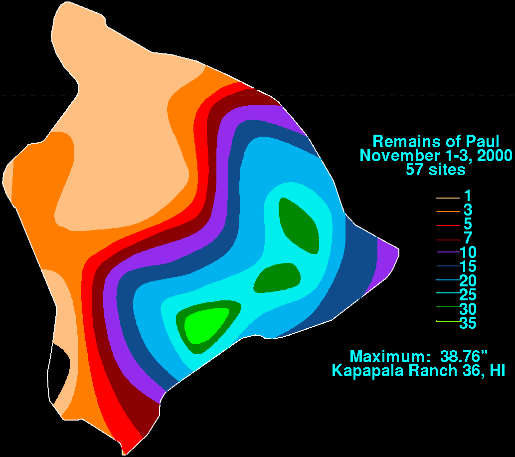
  385. ^ Roth, David M.; Hydrometeorological Prediction Center. "Remains of Paul" (GIF). Tropical Cyclone Point Maxima. United States National Oceanic and Atmospheric Administration's National Weather Service. Retrieved December 28, 2007.
  386. ^ Longworth, W. Mike (1988). Final report on Tropical cyclone Bola; 26 February – 4 March, 1988 (PDF) (Climatological Publication No. 23). Vanuatu Meteorological Service. Archived from the original (PDF) on April 3, 2014. Retrieved August 3, 2014.
  387. ^ Oates, Sue (September 3, 2000). "The South Pacific and southeast Indian Ocean tropical cyclone season 1998–99" (PDF). Australian Meteorological Magazine. Australian Bureau of Meteorology (49): 225, 235–237. Archived (PDF) from the original on February 18, 2012. Retrieved August 3, 2014.
  388. ^ Vanuatu Tropical Cyclone Warning Centre (2011). Tropical Cyclone Season Report 2010 to 2011 (Report). Vanuatu Meteorology and Geo-Hazards Department. Archived from the original on August 14, 2014. Retrieved August 3, 2014.
  389. ^ Neil, P.E; Barrance, A.J (September 1987). "Cyclone Damage in Vanuatu". The Commonwealth Forestry Review. 66 (3): 257. JSTOR 42608858.
  390. ^ a b c d e Terry, James P. (2007). "Chapter 5 – Meteorological conditions". Tropical cyclones: climatology and impacts in the South Pacific. Springer. pp. 75–77. ISBN 978-0-387-71542-1.
  391. ^ Padgett, Gary. "Monthly Global Tropical Cyclone Summary February 2004". Archived from the original on May 16, 2012. Retrieved August 3, 2014.
  392. ^ Pasch, Richard J. (November 22, 1993). "Casualty and Damage Statistics" (GIF). Preliminary Report: Tropical Storm Bret – 4–11 August 1993. National Hurricane Center. Retrieved January 17, 2007.
  393. ^ a b c "Typhoon Committee Country report 2007: Vietnam" (PDF). Vietnam Hydro meteorological Service. World Meteorological Organization. November 19, 2007. Retrieved June 5, 2010.
  394. ^ https://danviet.vn/khung-khiep-co-noi-luong-mua-3-ngay-do-duoc-len-den-gan-1700mm-20201020092931431.htm
  395. ^ a b c "Typhoon Committee Country report 2009: Vietnam" (PDF). Vietnam Hydro meteorological Service. World Meteorological Organization. January 25, 2010. Retrieved June 5, 2010.
  396. ^ "Mưa ở Quảng Bình là 'kỷ lục chưa từng có' - VnExpress". vnexpress.net. Retrieved November 13, 2016.
  397. ^ Joint Typhoon Warning Center (1991). "Northwest Pacific and North Indian Ocean Tropical Cyclones of 1990" (PDF). United States Navy. Archived from the original (PDF) on February 27, 2008. Retrieved March 12, 2007.
  398. ^ 국제 아동 지원 네트워크. 베트남: 제6호 태풍에 대한 요약 보고서XANGSANE. 2008년 3월 23일 회수된 웨이백 머신에 2008년 2월 13일 보관.

외부 링크