맥아더 하이웨이
MacArthur Highway_sign.svg) .svg) .svg) R-9 | |
|---|---|
| 마닐라북로 | |
.jpg) | |
| 경로 정보 | |
| 공공사업부 및 고속도로 유지 관리 | |
| 길이 | 684.855km[1](425.549mi) |
| 구성 요소 고속도로 | |
| 주요 접점 | |
| 남쪽 끝 | 칼루칸의 보니파시오 기념물 원 |
| |
| 노스엔드 | 바랑게이 마방구크, 아파리, 까가얀 |
| 위치 | |
| 지방 | |
| 주요 도시 | |
| 타운스 | |
| 고속도로 시스템 | |
공식적으로는 마닐라 북로(MNR 또는 MaNor)인 맥아더 고속도로는 필리핀 루손의 684.855km(425.549mi), 2~6차선, 국민 1차선, 3차선 고속도로로 마닐라 메트로 마닐라의 칼루칸에서 카가얀의 아파리까지 연결돼 있다. 필리핀에서 마할리카 고속도로에 이어 두 번째로 긴 도로다. 일로코스 수르에도 적용되지만,[2] 주로 칼루칸에서 판가시난 우르다네타까지 구간에서 맥아더 하이웨이로 알려져 있으며,[3] 마찬가지로 전체 길이로는 마닐라 북로라고 불린다.[1]
경로 설명
Manila North Road is a toll-free, two- to eight-lane national road that stretches for about 685 km (426 mi) from the Bonifacio Monument (Monumento) Circle in Caloocan to the northern province of Cagayan, passing through three cities in Metro Manila (Caloocan, Malabon, and Valenzuela), three provinces of Central Luzon (Bulacan, Pampanga and Tarlac), 일로코스 지방(팡가시난, 라 유니온, 일로코스 수르, 일로코스 노르트)의 4개 주와 카가얀 계곡 지역의 카가얀 주.[4] The highway parallels the North Luzon Expressway from Epifanio de los Santos Avenue (EDSA) to Mabalacat, the Subic–Clark–Tarlac Expressway from Mabalacat to Tarlac City, and the Tarlac–Pangasinan–La Union Expressway from Tarlac City to Rosario.
전체 도로는 공공사업 및 고속도로 부서의 일련의 노선번호 부여 시스템으로 구성된다. 칼루칸에서 기구인토까지, 라오아그에서 아파리까지 N1번 국도는 고속도로에 표지판이 붙어 있지 않지만 국도 1번 국도(N1)의 구성요소인 반면, 기구인토에서 라오아그까지 이어지는 나머지 노선은 필리핀 고속도로망의 국도 2번 국도(N2)로 완전히 지정되어 있다. 라오아그에서 아파리까지의 구간도 아시아 고속도로망의 범필리핀 고속도로나 아시아 고속도로 26번(AH26)의 일부다. 마닐라의 동맥 도로망 R-9의 구성요소이기도 하다. 아파리에 남아있는 구간은 번호 없는 3차 도로로 분류된다.
대체 이름
마닐라 북로에서 칼루칸에서 우르다네타까지 구간인 판가시난은 라유니온과 일로코스 수르로도 알려져 있지만 공식적으로 맥아더 하이웨이로 인정받고 있다.[5][3] 산 페르난도 시의 본거지인 라 유니온을 거쳐 현지에 케존 애비뉴로 알려져 있다. 라오아그 도시에서는 J.P. 리잘 애비뉴와 젠으로 지역적으로 알려져 있다. 세군도 가.[1]
역사
이 고속도로는 미국의 식민지 시대인 1928년에 시작된 구간으로 건설되었다.[6] 그것은 마닐라에서 다구판까지 옛 마닐라 철도 노선의 많은 노선을 따랐다. 그것은 3번 고속도로로 지정되었고 미군 초기 기록에도 3번 국도로 지정되었다.[7][8] 또한 현재의 리잘 애비뉴(루트 3A)의 정렬을 통해 마닐라까지 남쪽에 도달했다; 칼루칸에서 발렌주엘라(옛 폴로)에 이르는 고속도로 구간은 한때 리잘 애비뉴 익스텐션의 일부였다.[2] However, Highway 3 used a different alignment in Valenzuela, that exist until today as a mixture of streets in Malanday, and in western Bulacan, existing today as the Pan-Philippine Highway (N1/AH26) and Pulilan Regional Road (N115) in Pulilan and Calumpit, instead of the present-day alignment through Malolos.[9] 이 고속도로는 결국 북쪽의 일로코스 지방에 도달했고 마닐라 북쪽 도로로 알려지게 되었다.[4] 분명히 1950년대에는 카가얀-일로코스 노르트 로 알려진 구간을 인수하면서 카가얀의 아파리 쪽으로 더 멀리 도달했다.[2][10]
1961년 6월 17일, 제2차 세계대전 당시 필리핀의 라이베레이터인 더글러스 맥아더 장군을 기리기 위해 칼루칸과 우르다네타 사이의 마닐라 북로 구간이 변경되었다.[5][7]
교차점
메트로 마닐라


 AH 26 (N1) (EDSA) / AH 26 (N120) (삼슨 로드) / N150 (리졸 에비뉴 익스텐션) (Calocan의) 고속도로의 남쪽 종착역.
 발렌주엘라 카루하탄의 E5(NLEX 하버 링크)
 발렌주엘라 말린타에 있는 N118 (메이산로)
불라칸
팜팡가
 산페르난도의 N3
 엔젤리스의 N216
 Angeles의 N217 (북단 종단 2개)
 엔젤리스의 N215
 마발라캇주 마비가의 E1 (클라크 스퍼 로드)
 마발라카트의 N213
- Mabalacat, Dolores의 E1 (SCTEX)
탈락
팡가시난 시

 로잘레스의 N56 / N212
 우르다네타에 있는 N57. 마닐라 북로의 맥아더 하이웨이 구간의 공식 북쪽 끝.
- Urdaneta의 E1(TPLEX)
 비날로난의 N210
- 포조루비오의 E1(TPLEX)
라 유니온
 로사리오 캠프 1 N54 (케논 로드)
- 로사리오 주 수부섭의 E1(TPLEX)
 로사리오의 N209(남쪽 종단 2개)
 아구인 N208
 N55인 아구
- N54년 바우앙에서

 산페르난도의 N219
 산페르난도의 N218
일로코스 수르
일로코스 노르트
카가얀
 아불룩의 N223
 아불룩의 N121
- AH 26 (N1) 아파리. N1/AH26에서 번호 없는 3차도로 전환.
갤러리
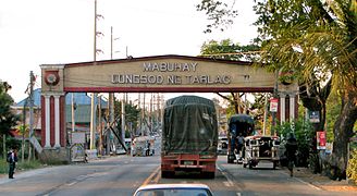
탈락 시로 접근하는 고속도로

팡가시난 로잘레스의 돈 테오필로 시손 다리

라유니온 로사리오에 N2 안심표지판이 있는 마닐라북로

일로코스 수르 산타크루즈로 진입하는 마닐라북로

Patapat Viador가 운반하고 N1의 제2부로서 AH26 동시성을 가진 Marila North Road

.jpg)


.jpg)
(2018-11-25).jpg)


참고 항목
참조
- ^ a b c "Road and Bridge Inventory". Department of Public Works and Highways. Retrieved September 26, 2021.
- ^ a b c Executive Order No. 483 (6 November 1951), Establishing the Classification of Roads, retrieved November 6, 2021
- ^ a b "Advisory: Road works along MacArthur Highway in La Union and Ilocos Sur". Official Gazette of the Republic of the Philippines. March 23, 2016. Retrieved September 26, 2021.
- ^ a b "Jica, World Bank to maintain 500-km MacArthur Highway". BusinessMirror. Archived from the original on 14 August 2014. Retrieved 14 August 2014.
- ^ a b Republic Act No. 1080 (17 June 1961), An Act Providing that the Highway from the City of Manila to the Municipality of Lingayen, Province of Pangasinan, Passing Through the Municipality of Tarlac, Province of Tarlac, and the Municipalities of Villasis, Urdaneta, Sta. Barbara, Calasiao, Dagupan, and Binmaley, All in the Province of Pangasinan, Shall Hereafter be Known as the Macarthur Highway, retrieved August 14, 2014
- ^ "A window into Valenzuela City's past". BusinessMirror. Archived from the original on August 14, 2014. Retrieved August 14, 2014.
- ^ a b The MacArthur Highway and Other Relics of American Empire in the Philippines. Joseph P. McCallus. Retrieved August 14, 2014.
- ^ Manila and Suburbs (Map). July 25, 1944. Retrieved September 5, 2021.
- ^ 1944 Army Map Service Road Map of Northern Luzon, Philippines (Map). 1:1000000. Washington D.C.: Army Maps Service, Corps of Engineers. 1944. Retrieved September 5, 2021.
- ^ Executive Order No. 113 (2 May 1955), Establishing the Classification of Roads, retrieved November 6, 2021
| 위키미디어 커먼즈에는 맥아더 하이웨이와 관련된 미디어가 있다. |
| ||||||||||||||||||||||
| ||||||||||||||||||||||
| 고속도로 |
| ||||||
|---|---|---|---|---|---|---|---|
| 국도 |
| ||||||


