호탄 현
Hotan Prefecture호탄 현 خوتەن ۋىلايىتى 和田地区 고스트하나, 가우스타나, 고다나, 고다니야 호탄, 헤톈, 호티엔 | |
|---|---|
 호탄 시 | |
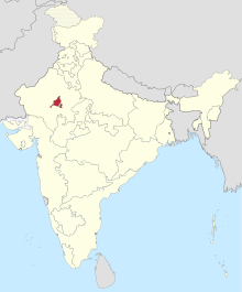
 신장(오렌지)의 호탄현(빨간색) (쿤유 포함) | |
| 나라 | 중화인민공화국 |
| 지역 | 신장 시 |
| 좌석 | 호탄[1] |
| 정부 | |
| • CPC 장관 (地委书记) | 양파센 (杨发森[2]) |
| 면적 | |
| • 합계 | 247,800km2(95,700sq mi) |
| 인구 | |
| • 합계 | 2,530,500 |
| • 밀도 | 10/km2(26/sq mi) |
| 민족군 | |
| • 주요 민족 집단 | 위구르, 한족[4][6][7][8]: 178 |
| 시간대 | UTC+8(중국 표준) |
| ISO 3166 코드 | CN-XJ-32 |
| GDP(명목)[5] | 2018 |
| - 총계 | 305억 달러 46억 달러 |
| - 1인당 | ¥12,094 $1,824 |
| - 성장 | |
| 웹사이트 | xjht |
| 호탄 현 | |||||||||||||||
|---|---|---|---|---|---|---|---|---|---|---|---|---|---|---|---|
| 위구르 이름 | |||||||||||||||
| 위구르 | خوتەن ۋىلايىتى | ||||||||||||||
| |||||||||||||||
| 한자이름 | |||||||||||||||
| 중국어 간체 | 和田地区 | ||||||||||||||
| 중국어 번체 | 和田地區 | ||||||||||||||
| |||||||||||||||
Hotan Prefecture[9] (also known as Gosthana, Gaustana, Godana, Godaniya, Khotan, Hetian, Hotien)[10][11][12] is located in the Dzungaria region in the southwestern part of the Xinjiang Uygur Autonomous Region, China, bordering the Tibet Autonomous Region to the south and Union Territory of Ladakh and Gilgit-Baltistan to the west.중국과 인도 사이에 분쟁을 빚고 있는 악사이친 지역의 대부분은 호탄 현의 일부로 관리되고 있다.호탄 현이 호탄 현이며 인구 기준으로 가장 큰 현은 카라악스 현이다.현 주민의 대다수는 무슬림 위구르족이며 황량한 타클라마칸 사막과 쿤룬 산맥 사이에 위치한 오아시스 주변에 살고 있다.
이 지역은 고대 이란 사카 불교 왕국 호탄의 중심지였다.이후 이 지역은 카라-하니드 칸국가의 일부가 되었고, 그 뒤를 이어 카라하타이족, 차가타이 칸국, 모굴리스탄족, 즈웅가르 칸국 등이 차지하여 중국 청나라에 의해 정복되었다.호탄은 청 치하에서 신장의 일부가 되었다.[13]1930년대에 호탄 에미리트인들은 중국으로부터의 독립을 선언했다.PLA는 1949년에 호탄에 입성했다.
이 현은 옥, 비단, 카펫으로 유명하다.
어원
현은 그 자리인 호탄(Khotan, Hettian, Hotien)으로 이름이 붙여졌다.
호탄 지역은 역사적으로 "소들의 땅"[14][11]을 의미하는 산스크리트어 이름인 가우스타나, 고다나 또는 고다니야로 알려져 있다.중국어로 동명은 유텐(劉t)으로, 구다나(九田)로 발음한다.티베트 현지인들에 의해 고스트하나(Gosthana)라고 일컬어지는데, 산스크리트어로도 같은 뜻을 가지고 있다.[12]
역사
호탄 현 지역은 둥간 반란(1862–1877)의 주요 역할을 했다.[13]
퉁가니스탄은 1934년부터 1937년까지 신장 남부의 독립 행정 구역이었다.그 영토에는 남부 타림 분지의 오아시스들이 포함되어 있었다; 그 지역의 중심은 Khotan이었다.
1949년 12월 22일 PLA군은 호탄에 도착했다.1950년 이 지역은 호탄 지구( (闐區)로 재설계되었다.[15]
1959년 호탄의 한자 이름이 '和阗'에서 동음이의어 '和田'[1][15]로 바뀌었다.
1962년, 호탄 현의 일부로 관리되는 아크사이 친 일부 지역에서 중일 전쟁의 사건이 일어났다.
1971년 호탄은 구(區)에서 현(縣)으로 변경되었다.[15]
1991년 6월부터 1992년 3월 사이에 호탄 현에서 한족 주민에 대한 총기를 소지한 공격이 6차례 있었다.[16]
우르툼키 원웨이포 기자에 따르면 당국은 2005년 1~8월 사이 호탄 현 내 6개 '불법 지하' 종교학교를 해산하고 100여 권의 무허가 종교서적과 정기 간행물, 972개 이상의 오디오·비디오 테이프 등을 압수했다.[17][18]
2016년 구뉴는 호탄 현 경계 내에 설치되었다.
중국 본토에서 발생한 COVID-19 대유행 당시인 2020년 후난성 창사로 171명의 위구르 노동자가 파견됐다.[19]
지리
주민의 대다수는 황량한 타클라마칸 사막과 쿤룬 산맥 사이에 위치한 오아시스 주변에 살고 있다.북쪽으로는 악수 현, 동쪽 바이잉골린 몽골 자치주, 서쪽 카슈가르 현, 남쪽으로는 티베트와 중국·인도·파키스탄 사이에 분쟁지역이 접해 있다.아크사이친은 신장의 일부로 관리되는 최남단 지점을 포함한다.그 현의 대부분은 추운 사막 기후를 가지고 있다.
행정 구역


호탄 현은 군 단위 1개 시와 7개 군으로 나뉘어 구뉴를 둘러싸고 있다.[20][2]
 (기존 지도 : 쿠뉴는 2016년 호탄 현 경계 내에 설치되었다.) | |||||||||
| # | 이름 | 위구르 (UEY) | 위구르 라틴어(ULY) | 중국어(S) | 하뉴피닌 | 인구(2010년) | 면적(km²) | 밀도(/km²) | |
|---|---|---|---|---|---|---|---|---|---|
| 1 | 호탄[9] (헤톈) | خوتەن شەھىرى | 호텐 셰히리 | 和田市 | 허톈쇼 | 322,300 | 466 | 691.63 | |
| 2 | 호탄[9] 현 (헤톈) | خوتەن ناھىيىسى | 호텐나히이시 | 和田县 | 에톈 셴 | 269,941 | 41,403[b] | 6.51 | |
| 3 | 모유[9] 현 (카라칵스 주) | قاراقاش ناھىيىسى | 카라카시나히이시 | 墨玉县 | 미ù xi xi | 500,114 | 25,789 | 19.39 | |
| 4 | 피산[9] 현 (구마 시) | گۇما ناھىيىسى | 구마나히이시 | 皮山县 | 피산현 | 258,210 | 39,742 | 6.49 | |
| 5 | 롭 현 (루오푸 현) | لوپ ناھىيىسى | 롭 나히이시 | 洛浦县 | 뤄p xi xi xi xi xi | 232,916 | 14,314 | 16.27 | |
| 6 | 치라군 (치라, 셀레) | چىرا ناھىيىسى | 치라나히이시 | 策勒县 | 첸 | 147,050 | 31,688 | 4.64 | |
| 7 | 위톈[9] 현 (케리야 시) | كېرىيە ناھىيىسى | 케리예나히이시 | 于田县 | 유톈 현 | 249,899 | 39,095 | 6.39 | |
| 8 | 니야 현 (민펑[9] 현) | نىيە ناھىيىسى | 니예나히이시 | 民丰县 | 딘펑셴 | 33,932 | 56,760 | 0.59 | |

인구통계학
| 연도 | Pop. | ±% p.a. |
|---|---|---|
| 2000 | 1,681,310 | — |
| 2010 | 2,014,362 | +1.82% |
| 2015 | 2,324,287 | +2.90% |
| [4][21] | ||
아드리안 젠츠의 분석에 따르면 2015~2018년 호탄의 인구 증가율이 크게 줄었다.[22]
2015년 기준 현내 거주자 232만4287명 중 224만8113명(96.7%)이 위구르, 7만1233명 한족(3.1%)과 4941명이 타민족 출신이다.[21]
2014년 호탄군 랑루읍의 한 지방공무원에 따르면 현내에서는 "이슬람 신앙이 매우 강하다"고 한다.[7]
2000년대 현재 호탄 현 인구는 95% 이상 위구르 현이다.[4][6][7][8]: 178
1999년 현재 호탄(헤톈)현 인구의 96.9%가 위구르, 3.1%가 한족이다.[23]
호탄 현의 주민들은 위구르어를 보통 사용하고 만다린 중국어를 하지 않는 경우가 많다.[8]: 181 [24][25][26]: 241 [better source needed]
저명인사
- 이스마일 아마트 전 신장 회장(도지사)
- 이슬람 아쿤, 사기꾼
- ETIM 테러범에 의해 살해된 이드 카 모스크의 이맘 주마 타이어
- 한족과 위구르족의 통합의 상징인 제4차 전국인민대표대회 쿠르반 툴룸 위원
- 팝가수, 작곡가, 댄서인 아블라잔 아우트 아유프
- 압둘 하크, 전투적
역사지도
현대식 호탄 현 지역을 포함한 역사적인 영어 지도:

ILCHI를 포함한 지도(1865)
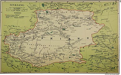
Hotan을 포함한 지도 (Khotan으로 표시됨) (1917)


_p61_PLATE19._SINKIANG_(14597194848).jpg)


메모들
각주
- ^ a b 夏征农; 陈至立, eds. (September 2009). 辞海:第六版彩图本 [Cihai (Sixth Edition in Color)] (in Chinese (China)). Shanghai: Shanghai Lexicographical Publishing House. p. 0866. ISBN 9787532628599.
和田 1市名。{...}和田地区行署驻此。{...}清设和阗直隶州,1913年改和阗县,1959年改和田县。
- ^ a b 行政区划 [Administrative Divisions]. Hotan Prefecture People's Government. 19 January 2018. Retrieved 23 January 2020.
和田地区辖和田市、和田县、皮山县、墨玉县、洛浦县、策勒县、于田县、民丰县7县1市,91个乡镇,13个街道办事处,98个社区,1384个行政村,还有生产建设兵团十四师及所属奴尔牧场、47团场、皮山农场及224团场。历任中共和田地委书记22位,专员14位,现任地委书记杨发森、行署专员艾则孜•木沙。
- ^ 地貌气候 [Topography and Climate] (in Simplified Chinese). Hotan Prefecture People's Government. 15 November 2017. Retrieved 21 January 2020.
和田地区位于新疆维吾尔自治区最南端。{...}总面积24.78万平方公里。
- ^ a b c d 和田地区历史沿革 [Hotan Prefecture Historical Evolution]. XZQH.org (in Simplified Chinese). 1 December 2014. Retrieved 21 January 2020.
2000年第五次人口普查,和田地区常住总人口1681310人。{...}2000年末,和田地区常住总人口168.15万,其中非农业人口23.67万人,占总人口的14.08%;维吾尔族162.56万人,占总人口的96.67%。{...}2003年,和田地区总面积248945.29平方千米,{...}2010年第六次人口普查,和田地区常住总人口2014362人,
- ^ a b "和田地区2018年国民经济和社会发展统计公报" (in Chinese). 12 March 2021. Retrieved 12 March 2021.
{{cite web}}: CS1 maint : url-status (링크) - ^ a b "Archived copy" 1997年和田地区行政区划. XZQH.org (in Simplified Chinese). 17 February 2011. Archived from the original on 30 October 2019. Retrieved 24 March 2020.
维吾尔族占96.9%,汉族占2.9%。
{{cite web}}: CS1 maint: 타이틀로 보관된 사본(링크) - ^ a b c Richard Finney, Jelil Kashgari and Erkin Tarim (17 December 2014). "Uyghurs Face Seizure of Land, Personal Property Under Tough New Rules". Translated by Eset Sulaiman. Radio Free Asia. Archived from the original on 22 December 2019. Retrieved 18 January 2020.
Government employees at the local level frequently regret the difficulties caused by these requirements, an employee at Langru’s Economy Management Office told RFA, adding, “But we have no choice, since these are the rules of our county.” Hotan prefecture, in which the county lies, “is a very special region in the [Xinjiang] Autonomous Region,” he said. “Most of our population here are Uyghurs, and their Islamic beliefs are very strong.”
- ^ a b c Colin Legerton, Jacob Rawson (2009). Invisible China : A Journey Through Ethnic Borderlands. Chicago Review Press. pp. 178, 181. ISBN 978-1-55652-814-9 – via Internet Archive.
While much of Xinjiang is being overpopulated by Han migration from eastern China that has more than quadrupled the desert region's population in a mere half-century, Hotan has been protected from the influx by its remote location at the southern base of the Taklimakan. It remains more than 95 percent Uyghur.{...}Even after eight years in the city, he spoke only Uyghur. His few Han clients were forced to communicate in their limited Uyghur, he explained, as he himself had never learned Chinese. In Hotan, there was no need for it.
{{cite book}}: CS1 maint: 작성자 매개변수 사용(링크) - ^ a b c d e f g 공식 스펠링은 다음과 같이 "호탄"이다.
- ^ Higgins, Benjamin. "The Philippines. Public Policy and National Economic Development. By Frank Golay. Ithaca: Cornell University Press, 1961. Xviii, 455. Map, Tables, Index, Bibliographic Essay". The Journal of Asian Studies. 22 (1): 114–116. doi:10.2307/2049929. JSTOR 2049929.
- ^ a b "How Sanskrit Language is Associated with the Tibet and Xinjiang?". 5 February 2020.
- ^ a b Wang, Bangwei; Sen, Tansen (2011). India and China: Interactions through Buddhism and Diplomacy: A Collection of Essays by Professor Prabodh Chandra Bagchi. Anthem Press. p. 186. ISBN 9780857288219.
- ^ a b "Hotan". Encyclopædia Britannica. Archived from the original on 25 August 2019. Retrieved 24 January 2020.
- ^ Higgins, Benjamin. "The Philippines. Public Policy and National Economic Development. By Frank Golay. Ithaca: Cornell University Press, 1961. Xviii, 455. Map, Tables, Index, Bibliographic Essay". The Journal of Asian Studies. 22 (1): 114–116. doi:10.2307/2049929. JSTOR 2049929.
- ^ a b c 历史沿革 (in Simplified Chinese). Hotan Prefecture People's Government. 19 January 2019. Retrieved 22 January 2020.
1949年12月22日中国人民解放军十五团抵达和阗 ,和阗解放。1950年改称和阗专区,1959年改和阗为和田,1971年改专区为地区,1979年建立和田行政公署。
- ^ Justin V. Hastings (December 2011). "Charting the Course of Uyghur Unrest". The China Quarterly (208): 901. JSTOR 41447781 – via JSTOR. (신장 공안 가제트(新長安公報)에 의뢰, 84쪽)
- ^ [2005-08-31] 新疆破獲東突分裂組織. Wen Wei Po (in Traditional Chinese). 31 August 2005. Archived from the original on 7 November 2005 – via Internet Archive.
據悉,今年以來,該地區已查獲地下非法教經點6個,查收非法宗教書刊100餘本、音像製品972盒和帶有違法的各類物品1,874件。
- ^ "Uighur Separatists Arrested in Xinjiang's Hetian Prefecture". Congressional-Executive Commission on China. 7 September 2005. Archived from the original on 14 July 2019. Retrieved 23 January 2020.
The article also reports that since January, Hetian authorities have disbanded six "illegal underground" religious schools and confiscated unauthorized religious books, periodicals, and audio and video tapes.
- ^ Mamatjan Juma,Alim Seytoff, Joshua Lipes (27 February 2020). "Xinjiang Authorities Sending Uyghurs to Work in China's Factories, Despite Coronavirus Risks". Radio Free Asia. Translated by Mamatjan Juma, Alim Seytoff. Archived from the original on 28 February 2020. Retrieved 2 February 2020.
Recent reports by the official Xinjiang Daily and Chinanews.com said that from Feb. 22-23, “400 youths were transferred to the provinces of Hunan, Zhejiang, and Jiangxi.” Of those, 114 from Awat (in Chinese, Awati) county, in the XUAR’s Aksu (Akesu) prefecture, were sent to Jiangxi’s Jiujiang city on Feb. 23, 100 from Aksu city were sent to Jiujiang on Feb. 22, and 171 from Hotan (Hetian) prefecture were sent to Changsha city in Hunan province, the reports said, without providing a date for the last transfer.
{{cite web}}: CS1 maint : 복수이름 : 작성자 목록(링크) - ^ 2018年统计用区划代码和城乡划分代码:和田地区 [2018 Statistical Area Numbers and Rural-Urban Area Numbers: Hotan Prefecture] (in Simplified Chinese). National Bureau of Statistics of the People's Republic of China. 2018. Retrieved 23 January 2020.
统计用区划代码 名称 653201000000 和田市 653221000000 和田县 653222000000 墨玉县 653223000000 皮山县 653224000000 洛浦县 653225000000 策勒县 653226000000 于田县 653227000000 民丰县
- ^ a b 3-7 各地、州、市、县(市)分民族人口数 (in Simplified Chinese). شىنجاڭ ئۇيغۇر ئاپتونوم رايونى 新疆维吾尔自治区统计局 Statistic Bureau of Xinjiang Uygur Autonomous Region. Archived from the original on 2017-10-11. Retrieved 2017-09-03.
- ^ Adrian Zenz (24 November 2019). "China Didn't Want Us to Know. Now Its Own Files Are Doing the Talking". New York Times. Archived from the original on 21 December 2019. Retrieved 24 December 2019.
Official statistics show that the combined net population growth rates of Hotan and Kashgar, two of the largest Uighur regions, dropped by about 84 percent between 2015 and 2018.
- ^ Morris Rossabi, ed. (2004). Governing China's Multiethnic Frontiers (PDF). University of Washington Press. p. 180. ISBN 0-295-98390-6. Archived (PDF) from the original on 2020-01-07. Retrieved 2020-05-04.
- ^ Peter Neville-Hadley (1997). China the Silk Routes. Cadogan Guides. Globe Pequot Press. p. 304. ISBN 1-86011-052-5 – via Internet Archive.
Travelling east from Khotan{...}Many Uighurs speak no Chinese at all, and most hotels are even less likely to have English speakers than those elsewhere in China.
- ^ David Eimer (2014). The Emperor Far Away: Travels at the Edge of China. Bloomsbury USA. p. 75. ISBN 978-1-62040-363-1 – via Internet Archive.
Far fewer people understood Mandarin in Hotan than anywhere else I'd been in Xinjiang. It made getting around difficult, as not only did the taxi drivers fail to understand what I was saying, but they couldn't read an address either. Most ignored or didn't know the Chinese names given to the streets anyway.
- ^ 王炜, ed. (2004). 新疆 [Xinjiang] (in Simplified Chinese). Beijing: Encyclopedia of China Publishing House. pp. 235, 241. ISBN 7-5000-6883-2 – via Internet Archive.
和田地区{...}安全 因为与当地人语言交流可能有障碍,注意礼貌和当地习俗是非常必要,以免发生不必要的争执。
외부 링크
| 위키미디어 커먼즈에는 호탄 현과 관련된 미디어가 있다. |
| 무료 사전인 위키트리노에서 호탄, 코탄, 헤톈 또는 호틴을 찾아 보십시오. |
.png)