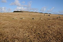
페르나크레
Fernacre 페르나크레 돌원 | |
| 위치 | 보드민 무어, 콘월 |
|---|---|
| 좌표 | 50°35′24″n 4°37′21″w/50.58995°N 4.62237°W좌표: 50°35°24°N 4°37°21°W / 50.58995°N 4.62237°W / |
| 유형 | 스톤 서클 |
| 역사 | |
| 기간 | 청동기 시대 |
Fernacre(그리드 참조 SX14477997)는 영국 [1][2]콘월 소재 보드민 무어의 세인트 브루어드에서 북동쪽으로 1.25마일(2.01km) 떨어진 데란크 강의 경사면에 있는 돌 원이다.
묘사
고사리 땅을 의미하거나 요정의 [3][4]옛 복수형인 페렌에서 유래한 것으로 추정되는데, 페렌은 고대 코니쉬에게 신성했다고 한다.Fernacre는 콘월에서 가장 큰 돌 서클 중 하나이다.그것은 북서쪽에서 남동쪽으로 약간 평평하고, 크기는 46.2m x 43.[5]3m이다. 원 안에는 68개 또는 69개의 돌이 있으며, 그 안에 3개가 더 옮겨져 있고, 38개 또는 39개가 똑바로 서 있다.그것들은 1.3미터(4.3피트) 높이의 가장 높은 돌과 2.1미터(6.9피트)[6] 떨어진 가장 긴 돌로 땅 속으로 깊이 가라앉아 있다.Fernacre는 Rough Tor에서 [2]Garrow에 이르는 중세 드라이브 도로의 시작을 나타내는 표시입니다.
고고학
Fernacre 농장이라고 불리는 유적은 서기 [7]1327년에 처음 기록되었다.인근 풍경에는 수많은 오두막 원들이 점재하고 있으며 페르나크레와의 연대가 이것들과 [8]동시대의 것이라는 주장이 제기되어 왔다.이 오두막집들에서는 뼈나 유골은 발견되지 않았고,[9] 단지 몇 개의 조각난 부싯돌만이 그 위치를 알 수 있었다.Fernacre 정착지는 164에이커의 면적을 차지하고 있으며, 그 중 84에이커는 [2]농사를 지은 흔적이 있다.신석기 시대나 청동기 [10]시대에 지어진 것으로 추정되지만, 유적지의 연대는 불확실하다.서클의 [11]남동쪽에 흙막이 흔적이 있다.
얼라인먼트
Fernacre는 정북쪽에 위치한 Rough Tor와 [12]정동에 위치한 Brown Willy 사이에 중심적인 위치를 가지고 있습니다.Garrow Tor는 또한 동쪽에 있고 Louden Hill은 서남서쪽에 있습니다.Stannon과 Brown Willy Cairns 사이의 동쪽 방향으로 직선거리로 100피트 밖에 떨어져 있지 않습니다.또 다른 작은 직선거리는 분점 [4][13]일출을 표시하기 위해 Brown Willy로 가는 길에 동쪽 방향으로 이 줄에 서 있습니다.윌리엄 페이지는 Fernacre의 중심에서 보았을 때 5월 1일의 일몰은 대략 Louden [14]Hill과 일직선이 될 것이라고 지적한다.
문학.
- William Borlase (1754). Observations on the antiquities, historical and monumental, of the county of Cornwall ...: Consisting of several essays on the first inhabitants, Druid-superstition, customs, and remains of the most remote antiquity, in Britain, and the British Isles ... With a summary of the religious, civil, and military state of Cornwall before the Norman Conquest ... Printed by W. Jackson, in the High-Strand.
- William Copeland Borlase (1872). Naenia Cornubiae: the cromlechs and tumuli of Cornwall. Llanerch. ISBN 978-1-897853-36-8.
- William C. Lukis (1885). The prehistoric stone monuments of the British Isles: Cornwall. Printed for Nichols and Sons for the Society of Antiquaries.
- Aubrey Burl (2005). A guide to the stone circles of Britain, Ireland and Brittany. Yale University Press. ISBN 978-0-300-11406-5.
레퍼런스
- ^ William C. Lukis (1885). The prehistoric stone monuments of the British Isles: Cornwall. Printed for Nichols and Sons for the Society of Antiquaries.
- ^ a b c Karin Altenberg (October 2003). Experiencing landscapes: a study of space and identity in three marginal areas of medieval Britain and Sweden. Almqvist & Wiksell. ISBN 978-91-22-01997-8.
- ^ Susan M. Pearce (1981). The archaeology of South West Britain. Collins. p. 212.
- ^ a b British Association for the Advancement of Science. Meeting; British Association for the Advancement of Science (1908). Report of the annual meeting. Office of the British Association. p. 371.
- ^ Aubrey Burl (2005). A guide to the stone circles of Britain, Ireland and Brittany. Yale University Press. p. 32. ISBN 978-0-300-11406-5.
- ^ William Page (1906). Cornwall. Archibald Constable & Co. p. 394.
- ^ Nigel Harvey (1980). The industrial archaeology of farming in England and Wales. B.T. Batsford. ISBN 978-0-7134-1845-3.
- ^ Society of Antiquaries of London (1908). Archaeologia, or miscellaneous tracts relating to antiquity. The Society.
- ^ American journal of archaeology. 1910.
- ^ Prehistoric Society (London; England); University of Cambridge. University Museum of Archaeology and Ethnology (2005). Proceedings of the Prehistoric Society for ... University Museum of Archaeology and Ethnology. p. 357.
- ^ Rodney Castleden (1992). Neolithic Britain: new stone age sites of England, Scotland, and Wales. Routledge. p. 37. ISBN 978-0-415-05845-2. Retrieved 23 March 2011.
- ^ Harold Bayley (October 2004). Archaic England: An Essay in Deciphering Prehistory from Megalithic Monuments Part Two 1919. Kessinger Publishing. p. 550. ISBN 978-1-4191-7324-0.
- ^ Thomas Rice Holmes (1971). Ancient Britain and the invasions of Julius Caesar. Books for Libraries Press. p. 211.
- ^ William Page. The Victoria history of the county of Cornwall. Constable. Retrieved 23 March 2011.


