10번가(맨하탄)
Tenth Avenue (Manhattan)루트 맵:
| 암스테르담 애비뉴(59번가 북쪽) | |||
 | |||
 | |||
| 주인 | 뉴욕 시 | ||
|---|---|---|---|
| 유지 보수자 | 디스크 | ||
| 길이 | 10.5 mi[1] (16.9 km) | ||
| 위치 | 맨해튼, 뉴욕시 | ||
| 사우스 엔드 | 웨스트 스트리트 | ||
| 북단 | 포트 조지 애비뉴 | ||
| 동쪽 | 9번가(59번가 이하) 콜럼버스 애비뉴(59번가 이상) | ||
| 서쪽 | 11번가(59번가 이하) 웨스트 엔드 애비뉴(59번가 이상) | ||
| 건설 | |||
| 위탁. | 1811년 3월 | ||


59번가와 193번가 사이의 암스테르담 애비뉴로 알려진 10번가는 뉴욕시 맨해튼 웨스트사이드에 있는 남북간 도로이다.West 110th Street(Cathedral Parkway라고도 함)까지 상행선(북행) 교통량을 운반하며, 그 후 양방향 도로로 계속 이어집니다.
지리
10번가는 웨스트 빌리지/미트패킹 구역의 Gansevoort Street와 11번가 아래 블록에서 시작합니다.최남단 구간(14번가 아래 4블럭)에서는 10번가가 남행으로 운행됩니다.14번가 북쪽의 10번가(북행)는 일방통행 도로로 45블록 동안 상행으로 운행됩니다.웨스트 59번가와의 교차로에서는 암스테르담 대로가 되지만 중단 없이 계속되며, 양방향 통행이 [2][3]재개되는 Cathedral Parkway까지 일방통행으로 계속됩니다.
암스테르담 애비뉴로서 이 도로는 북쪽으로 129블록 뻗어 있으며, 웨스트 193번가에서 하이브리지 파크 남쪽 포트 조지 애비뉴와 연결되기 전에 184번가와 186번가 사이에 있는 예시바 대학의 윌프 캠퍼스를 통과할 때 각 방향으로 한 차선으로 좁혀집니다.
남쪽의 암스테르담 애비뉴와 연결되지 않은 하이브릿지 파크의 북쪽에서 10번가는 다이크만 스트리트의 할렘 리버 드라이브 북쪽 종점에서 브로드웨이에 합류하는 웨스트 218번가의 교차점까지 1마일도 채 되지 않습니다.
역사
10번가는 자치구의 서쪽에 있는 첼시와 헬스 키친 인근을 지나 어퍼 웨스트 사이드, 모닝사이드 하이츠, 할렘, 워싱턴 하이츠를 거쳐 암스테르담 애비뉴로 이어진다.이 지역들 중 상당수는 20세기 내내 노동자 계층이거나 가난한 지역이었다.그 거리는 오랫동안 상업적인 교통으로 유명했다.20세기 초까지 [4]그 거리에는 급경사의 철도가 있었다.
허드슨 리버 철도의 웨스트 사이드 라인은 웨스트 스트리트와의 교차로에서 34번가의 상부 도시역까지 10번가를 따라 달렸고, 이후 11번가로 방향을 틀었다; 이 노선은 1849년 뉴욕 펙스킬까지 완공되었다.선로권의 이 부분에는 레일이 도로를 따라 경사지게 놓였고, 기관차가 허용되지 않았기 때문에 기관차가 더미 엔진으로 끌렸고, 1851년에 기술된 바에 따르면, 차량은 스스로 연기를 빨아들였다.시내를 지나는 동안, "웨스트 사이드 카우보이" 또는 "텐 애비뉴 카우보이"로 알려진 말을 탄 한 남자가 [5][6][7][8]경적을 울리며 접근했음을 알렸다.하지만, 화물 열차와 다른 교통들 사이에서 너무 많은 사고가 발생하여 "데스 애비뉴"[10]라는 별명이 10번가와 11번가 모두에[8][9] 붙여졌다.
위험에 대한 공개 토론은 1900년대 [11]초에 시작되었다.1929년, 시, 주, 뉴욕 중앙은 로버트 [13]모세에 의해 구상된 웨스트 사이드 개선 프로젝트에 [12]합의했다.13마일(21km) 프로젝트에서는 105개의 도로 건널목을 없애고 리버사이드 공원에 32에이커(13ha)를 증축했습니다.또한 웨스트사이드 고가 고속도로 건설도 포함되었습니다.1억5000만 달러(2017년 약 20억 달러)[14]가 넘는 비용이 들었다.
웨스트 59번가 북쪽의 10번가 부분은 1890년에 "죽음의 거리"와 거리를 두고 아직 "인기"[15]가 되지 않은 지역의 부동산 가치를 높이려는 지역 상인들의 요청에 따라 "암스테르담 거리"로 이름이 변경되었습니다.그 이름은 뉴 암스테르담으로 알려졌던 17세기 맨하탄의 초기 식민지화의 네덜란드 뿌리를 떠올리기 위한 것이었다.그들은 이 지역이 "신도시"와 "신 암스테르담"[16]이 되기를 바랐다.상원 위원회는 명칭 변경을 승인했지만 "Holland Avenue"를 먼저 검토한 후에야 변경되었다.; 변경은 결의안에 대한 투표 직전에 이루어졌다.그들의 승인에서, 이사회는 11번가에서 "West End Avenue"와 같은 지역의 다른 명칭 변경은 "특징하고 재산에 유익한 영향"을 미쳤다고 언급하였고, 그러한 명칭 변경은 "고속 [17]교통의 증가의 이점만큼 중요하다"고 언급하였다.
현재 하이브리지 공원의 좌석 구역인 포트 조지 놀이 공원은 1895년부터 [18]1914년까지 암스테르담 거리의 북쪽 끝에 위치해 있었습니다.
10번가와 암스테르담 거리는 편도 교통량을 두 단계로 나누어 북쪽으로 이동하도록 개조되었다.브로드웨이와의 교차로 남쪽에 있는 이 거리는 1948년 [19][20]11월 6일에 개조되었다.나머지는 1951년 [21]12월 6일에 110번가로 개조되었다.암스테르담 애비뉴는 110번가 북쪽에서 양방향 교통을 계속 수송한다.
20세기 후반의 부동산 붐 기간 동안, 대략 59번가에서 96번가까지의 암스테르담 거리는 이 도시에서 가장 비싼 주택가 중 하나가 되었다.
교통.
M11 버스는 14번가에서 110번가까지, 그리고 110번가에서 135번가까지 양방향으로 10번가와 암스테르담 애비뉴를 따라 북행으로 운행됩니다.72번가 북쪽에서 M7 버스는 106번가까지 북쪽 방향으로 운행됩니다.M100과 M101은 125번가 [22]북쪽 암스테르담 거리에 있습니다.
7번 지하철 연장의 일환으로,[23] 뉴욕 시 지하철의 7번과 <7> 열차는 2015년에 34번가까지 연장되었습니다.중간 정류장인 10번가([25]Thenth Avenue)는 원래[24] 계획되었지만 2008년에 공식 계획에서 제외되었다.1번 열차는 10번가의 Inwood 부분을 따라 207번가와 215번가의 [26]두 역을 운행합니다.IND 8번가 라인은 163번가에 역이 있습니다
72번가에서 [27][28]110번가까지 2016년에 보호 자전거 도로가 설치되었습니다.
주목 사이트
갤러리
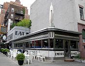
22번가의 엠파이어 다이너
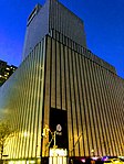
W. 53번가 모퉁이에 있는 10번가 811번지의 AT&T 빌딩.
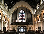
96번가에 있는 예수 로마 가톨릭 교회의 성명 내부
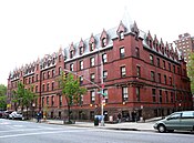
103번가에 있는 아메리칸 유스 호스텔 빌딩
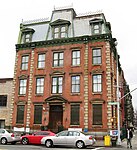
암스테르담 가 152번지 32번지 구 뉴욕경찰청 건물
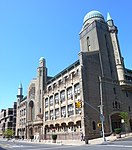
187번가에 있는 예시바 대학교 지스만 홀


대중문화에서
- The Rodgers and Hart Play On Your Toes (1936)에는 레이 볼거와 타마라 게바가 공연한 코믹 댄스곡 "10번가의 살인"이 포함되어 있다.그것은 나중에 무대, 영화, 텔레비전에서 공연되었다.그것은 뉴욕 시립 발레단에 의해 공연되었고 에디 알버트와 베라 조리나가 춤춘 영화 버전의 "On Your Toes"에 등장했습니다.전기 뮤지컬 '단어와 음악'(1948년)에서 진 켈리와 베라 엘렌이 '10번가의 살인' 발레 시퀀스를 연기한다.
- The Girl from 10th Avenue는 베티 데이비스가 주연한 1935년 드라마 영화이다.
- '10번가에서의 학살'은 1957년 범죄 영화의 이름이기도 하고 1974년 믹 론슨의 데뷔 앨범이기도 하다.
- 허드슨 강변의 모스크바에서 로빈 윌리엄스의 등장인물 블라디미르 이바노프는 암스테르담 가 1320번지에 살았다.
- '어머니를 만난 방법'에서 테드 모스비는 75번가와 암스테르담 가 모퉁이 근처에 살았다고 한다.
- Donald E에서. 웨스트레이크의 범죄 소설 "도르트문더" 시리즈는 가상의 O.J. 바 앤 그릴 (조직이 가장 좋아하는 모임 장소)이 암스테르담 거리에 위치해 있습니다.
- 미국 TV 드라마 슈트의 "아스터리스크" 에피소드에서 마이크 로스는 "오프 10번가" 아파트를 빌렸다고 언급했고, 그의 동료 레이첼 제인은 "방탄 조끼와 함께 오나요?"라고 대답했다.
- 암스테르담 애비뉴는 Night and Day II 앨범의 조 잭슨의 노래 "Stranger Than You"에 언급되어 있다.
레퍼런스
- ^ Google (December 1, 2015). "Tenth Avenue / Amsterdam Avenue" (Map). Google Maps. Google. Retrieved December 1, 2015.
- ^ Meyer, David (June 21, 2018). "Safer Bikeways Slated for Columbus Circle and Amsterdam Avenue". StreetsBlog. Archived from the original on July 17, 2019.
On 10th Avenue/Amsterdam Avenue — the street name shifts at 59th Street — DOT plans to extend the protected bike lane design it installed between 72nd Street and 110th Street two years ago.
- ^ Meyer, David (October 16, 2018). "OUTRAGE! DOT Delays Life-Saving Amsterdam Avenue Redesign in Fight With NIMBYs". StreetsBlog. Archived from the original on July 17, 2019.
Thompson spoke to Streetsblog after the meeting, where she and the board’s Vice Chairman Victor Edwards opposed the traffic-calming plan, which is not even as complete as the improvements made to one-way Amsterdam Avenue below 110th Street. Indeed, instead of a protected bike lane, the plan for the two-way stretch from 110th Street to 162nd Street would install unprotected lanes, painted medians, and turn lanes in both directions.
- ^ Robbins, L.H. (June 3, 1934). "Transforming the West Side: A Huge Project Marches On". The New York Times. Retrieved July 17, 2019.
- ^ Hudson River and the Hudson River Rail-Road. Boston: Bradbury & Guild. 1851. p. 12. Retrieved September 18, 2015.
- ^ 웨스트 사이드 카우보이 주간 하이라인 사진
- ^ "High Line History". Friends of the High Line. Archived from the original on September 22, 2014.
- ^ a b Amateau, Albert (April 30, 2008). "Newspaper was there at High Line's birth and now its rebirth". The Villager. Vol. 77, no. 48. Archived from the original on July 13, 2011.
- ^ Gray, Christopher (December 22, 2011). "When a Monster Plied the West Side". The New York Times. Archived from the original on May 17, 2014. Retrieved May 12, 2014.
The New York World referred to the West Side route as Death Avenue in 1892, long after the Park Avenue problem had been solved, saying 'many had been sacrificed' to 'a monster which has menaced them night and day.'
- ^ Dunlap, David W. (February 18, 2015). "New York City Rail Crossings Carry a Deadly Past". The New York Times. ISSN 0362-4331. Retrieved February 12, 2018.
- ^ "'Death Ave.' Ends as Last Rusty Rail Goes; Huge West Side Improvement Completed" (PDF). The New York Times. June 26, 1941. ISSN 0362-4331. Retrieved February 12, 2018.
- ^ "The Highline: past and present". GeoWeb, Harvard University. May 13, 2010. Archived from the original on October 23, 2014. Retrieved October 23, 2014.
- ^ Walsh, Kevin (September 2012). ""High Line"'s Last Frontier". Forgotten NY. Archived from the original on October 24, 2014.
- ^ "High Line History". Friends of the High Line. Archived from the original on September 22, 2014. Retrieved August 2, 2009.
- ^ Shepard, Richard F. (February 6, 1981). "Exploring the New Amsterdam Avenue". The New York Times. ISSN 0362-4331. Retrieved July 17, 2019.
- ^ Feirstein, Sanna (2001). Naming New York: Manhattan Places & How They Got Their Names. New York: New York University Press. p. 169. ISBN 978-0-8147-2712-6.
- ^ Moscow, Henry (1978). The Street Book: An Encyclopedia of Manhattan's Street Names and Their Origins. New York: Hagstrom Company. p. 22. ISBN 978-0-8232-1275-0.
- ^ Martens, Victoria (August 1, 2019). "Fort George Amusement Park". Museum of the City of New York. Retrieved September 2, 2019.
- ^ Ingraham, Joseph (7 November 1948). "Traffic Speeded on 9th, 10th Aves. By One-way Plan". The New York Times. Retrieved 28 August 2012.
- ^ "Ninth and Tenth Avenues Are One Way Permanently". The New York Times. 14 May 1949. Retrieved 28 August 2012.
- ^ "Two More Avenues One-way Thursday". The New York Times. 4 December 1951. Retrieved 28 August 2012.
- ^ "Manhattan Bus Map" (PDF). Metropolitan Transportation Authority. July 2019. Retrieved December 1, 2020.
- ^ *Fitzsimmons, Emma G. (September 10, 2015). "Subway Station for 7 Line Opens on Far West Side". The New York Times. Retrieved September 13, 2015.
- "New 7 line subway extension to the West Side opens". ABC7 New York. September 13, 2015. Retrieved September 13, 2015.
- Tangel, Andrew (September 13, 2015). "New Subway Station Opens on NYC's Far West Side". WSJ. Retrieved September 13, 2015.
- "Photos: NYC's Newest (And 469th) Subway Station, 34th Street-Hudson Yards, Is Open". Gothamist. September 13, 2015. Archived from the original on September 15, 2015. Retrieved September 13, 2015.
- ^ Chan, Sewell; Bagli, Charles V. (April 2, 2005). "M.T.A. Links Stadium Bid to Rail Extension". The New York Times.
- ^ Neuman, William (September 19, 2008). "No. 7 Extension Won't Include 10th Ave. Station". The New York Times.
- ^ "Subway Map" (PDF). Metropolitan Transportation Authority. September 2021. Retrieved September 17, 2021.
- ^ Meyer, David (May 20, 2016). "Eyes on the Street: First Signs of Amsterdam Avenue's Protected Bike Lane". StreetsBlog. Archived from the original on July 17, 2019.
- ^ Garofalo, Michael (June 26, 2018). "DOT plans new UWS bike lanes". West Side Spirit. Archived from the original on July 17, 2019.
The protected lane would continue past 59th Street, where 10th Avenue becomes Amsterdam Avenue, and connect to the existing protected bike lane on Amsterdam Avenue that begins at 72nd Street and runs to 110th Street.
외부 링크
 Wikimedia Commons의 10번가(맨하탄) 관련 미디어