노스서머셋
North Somerset노스서머셋 | |
|---|---|
 서머셋 내의 노스 서머셋 | |
| 주권국 | 영국 |
| 구성국 | 잉글랜드 |
| 지역 | 사우스웨스트잉글랜드 |
| 의례군 | 서머셋 |
| 관리본부 | 웨스턴 슈퍼마레 |
| 창조했다 | 1996년 4월 1일 |
| 정부 | |
| • 종류 | 단일 기관 |
| • 리더 | 스티브[1] 브리저 |
| • 평의회 | 전체적인 제어 없음[2] |
| • MP: | 존 펜로즈 C 리암 폭스 C |
| 지역 | |
| • 합계 | 144.66 평방 밀리(374.68 km2) |
| 인구. (2019년 중반)[3] | |
| • 합계 | 215,052 (82위) |
| 시간대 | UTC0(GMT) |
| • 여름 (DST) | UTC+1 (BST) |
| ISO 3166 코드 | GB-NSM |
| 웹 사이트 | http://www.n-somerset.gov.uk/ |
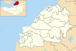
노스 서머셋은 잉글랜드 남서부 서머셋에 있는 단일 지구이다.이 지역은 서머셋 주의 일부에 걸쳐 있지만, 비수도권 카운티와는 독립적으로 관리된다.행정 본부는 웨스턴 슈퍼마레 시청에 있습니다.
1996년 우드스프링 구역에서 개명된 노스 서머셋은 브리스톨 시 및 카운티와 배스 및 노스이스트 서머셋, 멘디프, 세지무어 지방정부와 접해 있다.이 지역은 웨스턴-슈퍼-마레와 노스 서머셋의 국회의원 선거구로 구성되어 있다.
역사
1974년 4월 1일부터 1996년 3월 31일까지 이 지역은 에이본 카운티의 우드스프링 지역이었다(웨스턴-슈퍼-마레 북쪽 해안 근처의 고립된 중세 교회인 우드스프링 프리오리에서 이름을 따왔다).Woodspring 구는 Weston-super-Mare, Clevedon 및 Portishead 도시 지역구, 롱 애쉬턴 시골 지역구 및 Axbridge Routural 지역구의 일부 시 자치구는 Weston-super-Mare, Clevedon 및 Portishead 도시 지역구입니다.
정부는 [4]1996년 4월 1일부터 새로운 통일된 지역을 "노스 웨스트 서머셋"으로 부르자고 제안했지만, 의회는 대신 "노스 서머셋"이라는 이름을 채택하기로 투표했고, 그래서 "노스 웨스트 서머셋"이라는 이름은 널리 사용되지 않았다.평의회가 '노스 서머셋'[5]으로 이름을 변경했는지에 대해서는 법적 의구심이 남았지만 2005년 평의회는 이 문제를 [6]의심할 여지가 없는 것으로 하는 결의안을 통과시켰다.
정치
단일 기관인 노스 서머셋 의회는 4년마다 선출되며, 현재 각 선거마다 61명의 의원이 선출된다.1995년 첫 선거 이후 의회는 보수당 지배하에 있거나 과반수를 차지한 정당이 없다.2019년 선거 현재 평의회는 다음과 같은 [2]평의원으로 구성되어 있다.
| 파티 | 참의원 | |
| 독립적인 | 17 | |
| 보수당 | 13 | |
| 자유민주당 | 11 | |
| 노동당 | 6 | |
| 녹색당 | 3 | |
결산
이 지역의 주요 도시는 웨스턴-슈퍼-마레, 포르티스헤드, 클레베돈, 네일시 해안 마을이다.
- 애보츠 리
- 백웰, 밴웰, 바로 거니, 블래든, 블래든, 부르튼, 브로클리, 버링턴, 버컴
- 케임브리지 배치, Chelvey, Christon, Churchill, Clapton in Gordano, Claverham, Cleve, Clevedon, Congresbury
- 단점, Dundry
- 이스트엔드, 이스트휴이시, 이스트롤스톤, 이스트톤 인 고다노
- Failand, Farleigh, Felton, Flax Bourton
- 햄 그린, 허튼
- 아이스턴
- 켄, 쿠스토크, 킹스턴 시모어
- Leigh Woods, Locking, Lodway, Long Ashton, Lower Failand, Lower Langford, Loxton, Lulsgate Bottom
- 메이든 헤드, 밀턴
- 노스엔드, 노스웨스턴, 네일시
- 필, 포트베리, 포티스헤드, 푸스턴
- 레드클리프 베이, 레드힐, 레길, 릭포드
- 샌포드, 쉬프웨이, 시드콧, 세인트조르주, 세인트메리 그로브
- 티켄햄
- 오르막, 어퍼타운
- Walton in Gordano, West End, West Hewish, West Town, West Wick, Weston-super-Mare, Wick St. 로렌스, 윈포드, 윈스콤브, 월레, 랙설, 브링턴
- 야톤
관심장소
노스 서머셋의 자연 환경과 해안 도시들은 인근 도시에서 관광객들을 끌어 모읍니다.주목할 만한 지리적 특징은 다음과 같습니다.
유명한 종교 유적지로는 Woodspring Priory가 있다.
교구
경제.
노스 서머셋의 경제는 전통적으로 멘디프 힐에서 양털을 얻기 위해 사육되고 계곡에서 낙농을 하는 등 농업에 기반을 두고 있다.이것은 매년 노스 서머셋 쇼에서 기념된다.조지아 시대 동안 관광은 해안 도시, 특히 작은 마을에서 큰 휴양 도시로 성장한 웨스턴-슈퍼-마레에서 중요한 경제 부문이 되었다.20세기 중후반에는 관광이 감소했지만, 대부분의 영국 해안 휴양지들과 마찬가지로, 이 경제 부문은 안정되었다.
19세기에 주요 항구 도시인 브리스톨은 현대 선박들이 좁은 강 접근로를 벗어나 성장했다는 것을 발견했고 브리스톨 항은 해안의 새로운 부두를 위한 장소를 찾기 시작했다.그 중 첫 번째는 포티스헤드 항구로, 사우스웨일스산 석탄을 취급하고 있었지만, 이 역시 설비를 밑돌고 있다.새로운 로얄 포트베리 독은 자동차 수입량이 많은 것으로 유명하다.
이는 National Statistics Office for National Statistics Surmerset 및 South Gloistershire의 현재 기본 가격(240-253페이지)에 대한 지역 총 부가가치 추이를 수백만 영국 파운드 스털링 단위로 나타낸 차트이다.[11]
| 연도 | 지역 총 부가가치1 | 농업2 | 업계3 | 서비스4 |
|---|---|---|---|---|
| 1995 | 5,916 | 125 | 1,919 | 3,872 |
| 2000 | 8,788 | 86 | 2,373 | 6,330 |
| 2003 | 10,854 | 67 | 2,873 | 7,914 |
^1 반올림으로 인해 컴포넌트의 합계가 되지 않을 수 있습니다.
^2는 사냥과 임업을 포함한다.
^3에는 에너지와 건설이 포함됩니다.
^4는 간접적으로 측정된 금융중개서비스를 포함한다.
인구 통계
| 노스 서머셋 비교 | |||||
|---|---|---|---|---|---|
| 2001년 영국 인구 조사 | 노스서머셋 UA[12] | 사우스웨스트잉글랜드[13] | 영국[13] | ||
| 총인구 | 188,564 | 4,928,434 | 49,138,831 | ||
| 외국인 태생 | 9.5% | 9.4% | 9.2% | ||
| 하얀색 | 97.1% | 97.7% | 91% | ||
| 아시아의 | 1.7% | 0.7% | 4.6% | ||
| 블랙입니다. | 0.9% | 0.4% | 2.3% | ||
| 크리스찬 | 75.0% | 74.0% | 72% | ||
| 무슬림 | 0.2% | 0.5% | 3.1% | ||
| 힌두교 | 0.1% | 0.2% | 1.1% | ||
| 종교 없음 | 16.6% | 16.8% | 15% | ||
| 75세 이상 | 9.9% | 9.3% | 7.5% | ||
| 미취업 | 2.1% | 2.6% | 3.3% | ||
노스 서머셋은 약 145평방마일(380km2)의 면적을 차지하고 있으며, 85,000가구에 [14]거주하는 193,000명(1.4%)의 거주 인구를 가지고 있습니다.
노스 서머셋의 인구는 1950년대 이후 두 배로 증가했으며 2011년에는 6,184명 또는 3.0%, 2026년에는 17% 증가할 것으로 예상됩니다.노스서머셋의 45세 미만 인구 비율은 전국 평균보다 낮지만 인구 증가는 2034세대에서 가장 높을 것으로 예측된다.반대로 노스 서머셋은 잉글랜드와 웨일스의 다른 지역보다 고령자 비율(여성 60명 이상, 남성 65명 이상)이 4.2% 더 높다.75세 이상 인구의 비율이 전국 평균보다 30% 가까이 높아짐에 따라 이 격차는 연령에 따라 증가하여 상대적으로 [15]고령화된다.
2001년에는 노스 서머셋에 134,132명의 근로연령 인구가 살고 있었고 91,767명이 고용되어 있었다. 경제활동률은 68.4%였다.이는 2001년 [14]인구조사에서 68.8%였던 잉글랜드 서부의 경제활동률에 매우 근접한 것이다.
2001년 인구조사에 따르면 노스 서머셋 주민 중 1.38%가 자신이 눈에 보이는 인종 집단에 속한다고 밝혔으며 1.27%는 자신이 '백인 기타'[16]라고 답했다.
| 1801년 이후 인구[17] | |||||||||||||
| 연도 | 1801 | 1851 | 1901 | 1911 | 1921 | 1931 | 1941 | 1951 | 1961 | 1971 | 1981 | 1991 | 2001 |
|---|---|---|---|---|---|---|---|---|---|---|---|---|---|
| 인구[18] 노스 서머셋 | 16,670 | 33,774 | 60,066 | 68,410 | 75,276 | 82,833 | 91,967 | 102,119 | 119,509 | 139,924 | 160,353 | 179,865 | 188,556 |
교육
노스 서머셋의 유니터리 당국은 78개 학교에 지원을 제공하고 약 28,000명의 [19]학생들에게 교육을 제공합니다.
웨스턴 대학은 그 지역에서 더 많은 교육을 제공하는 주요 기관이다.University Centre Weston은 Bath Spa University 및 University of West of England와 연계하여 고등 교육 과정을 제공합니다.
「 」를 참조해 주세요.
레퍼런스
- ^ "Executive members". North Somerset Council. Retrieved 11 September 2021.
- ^ a b "North Somerset Council Election results for 2019". BBC News. Retrieved 11 September 2021.
- ^ "Population Estimates for UK, England and Wales, Scotland and Northern Ireland, Mid-2019". Office for National Statistics. 6 May 2020. Retrieved 6 May 2020.
- ^ "Article 4 of the Avon (Structural Change) Order 1995 (SI 1995/493)". 28 February 1995. Retrieved 9 October 2011.
- ^ "Report to the Executive". 14 June 2005. Archived from the original on 5 April 2012. Retrieved 9 October 2011.
- ^ "Minutes of the Extraordinary Meeting of the Council". 28 June 2005. Retrieved 22 August 2016.
- ^ a b c d e f g h i j k l m n o p q r s t u v w x y z aa ab ac ad ae af ag ah ai aj ak al am "2011 Census Profile". North Somerset Council. Archived from the original (Excel) on 4 January 2014. Retrieved 4 January 2014.
- ^ a b c d e f g h i j k l m n o p q r "Long Ashton RD". A vision of Britain Through Time. University of Portsmouth. Retrieved 4 January 2014.
- ^ a b c d e f g h i j k l m n o p q r s t "Axbridge RD". A vision of Britain Through Time. University of Portsmouth. Retrieved 4 January 2014.
- ^ "Clevedon UD". A vision of Britain Through Time. University of Portsmouth. Retrieved 4 January 2014.
- ^ "Regional Gross Value Added" (PDF). National Statistics. 21 December 2005. Retrieved 3 June 2007.
- ^ United Kingdom Census 2001 (2001). "Key Figures for 2001 Census: Census Area Statistics: Area: North Somerset". statistics.gov.uk. Retrieved 12 December 2007.
- ^ a b United Kingdom Census 2001 (2001). "Key Figures for 2001 Census: Census Area Statistics: Area: Bath and North East Somerset". statistics.gov.uk. Retrieved 12 December 2007.
- ^ a b "Local Area Agreement for North Somerset 2007–2010". North Somerset Partnership. Archived from the original on 7 June 2011. Retrieved 30 December 2007.
- ^ "Culture, Leisure and Tourism and Topic Paper" (PDF). North Somerset Core Strategy document. Archived from the original (PDF) on 8 February 2012. Retrieved 30 December 2007.
- ^ "North Somerset Council Race Equality Scheme 2007–2010". North Somerset Council. Archived from the original (Word) on 29 October 2007. Retrieved 30 December 2007.
- ^ 시간을 통한 영국의 비전
- ^ "North Somerset: Total Population". A Vision of Britain Through Time. Great Britain Historical GIS Project. Retrieved 13 December 2007.
- ^ "Schools". North Somerset. Archived from the original on 2 November 2007. Retrieved 19 December 2008.


