멜스 강
Mells River| 멜스 강 | |
|---|---|
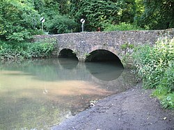
 느릅나무에 있는 멜스 강 다리 | |
| 위치 | |
| 나라 | 잉글랜드 |
| 자치주 | 서머셋 |
| 도시들 | 거니 슬레이드, 멜스, 그레이트 엘름, 프롬 |
| 물리적 특성 | |
| 원천 | |
| • 장소 | 영국, 서머셋 |
| • 고도 | 2 m (6 피트 7 인치) |
| 입 | 프로메 강 |
• 장소 | 프로미, 서머셋, 영국 |
• 좌표 | 51°145050nN 2°19′14″w/51.24722°N 2.32056°W좌표: 51°14°50°N 2°19°14°W / 51.24722°N 2.32056°W / |
| 유역 특징 | |
| 지류 | |
| • 오른쪽 | 핑거 스트림, 왓리 브룩, 너니 브룩 |
멜스 강은 영국 서머셋에 있는 멘디프 힐스 동부를 통해 흐른다.구르니 슬레이드에서 발원하여 프로메에서 프로메 강으로 합류하여 동쪽으로 흐릅니다.
그 강은 멜의 [1]시골 주택 단지인 멜스 파크의 경계 중 하나를 형성하고 있다.몇 킬로미터 하류에서 북쪽으로 워드베리 캠프와 남쪽으로 [2]테드베리 캠프 사이를 흐릅니다.그 강은 해리지 우즈 [3]자연보호구역의 서쪽을 통해 흐른다.
멜스 리버는 또한 1744년 [5]제임스 푸셀 3세가 세운 올드 아이언스톤[4] 워크스와 몇몇 다른 공장들에 동력을 공급했다.지금은 0.25헥타르의 생물학적으로 특별한 과학적 관심이 있는 장소이며, 관박쥐와 관박쥐가 [6][7]모두 사용하고 있습니다.
멜스강을 가로지르는 차선을 운반하는 Vobster Inn Bridge는 1764년으로 2등급에 [8]올랐다.그레이트 엘름에서는 1795년경에 지어진 머트리 [9]수로가 도싯 운하와 서머셋 운하를 강을 가로질러 운반했다.
강은 Whatley [10]Quarry에서 나오는 배수구를 통과한다.배수구 하류에는 멜스 강 싱크대가 있습니다이것은 수위가 높을 때는 용수철 역할을 하고,[11] 수위가 낮을 때는 석회암을 통해 지하 대수층으로 가라앉는 역할을 합니다.물의 흔적은 이것이 2.5km (1.6mi) 길이의 강의 지하 부분의 일부라는 것을 보여주었다.고고학 조사 결과 털코뿔소 뼈와 1세기 청동 [12]브로치가 발견됐다.
레퍼런스
- ^ "Park, Mells". Somerset Historic Environment Record. Somerset County Council. Retrieved 25 September 2009.
- ^ Phelps, William (1836), The History and Antiquities of Somersetshire: Being a General and Parochial Survey of that Interesting County. To which is Prefixed an Historical Introduction, with a Brief View of Ecclesiastical History; and an Account of the Druidical, Belgic-British, Roman, Saxon, Danish, and Norman Antiquities, Now Extant, J.B. Nichols and son, p. 105, retrieved 19 August 2016
- ^ Harridge Woods Leafet (PDF), Somerset Wildlife Trust, retrieved 22 August 2016
- ^ "The Case for Extending the Mendip Hills Area of Outstanding Natural Beauty". Mendip Hills Society. 2005. Retrieved 16 October 2010.
- ^ Atthill, Robin (1964). Old Mendip. Newton Abbott: David and Charles. ISBN 0-7153-5171-0.
- ^ "English Nature citation sheet" (PDF). 2006. Retrieved 25 July 2006.
- ^ Thornes, Robin (2010). Men of iron. The Fussells of Mells. Frome Society for Local Study. ISBN 978-0-9565869-1-9.
- ^ "Vobster Inn Bridge". historicengland.org.uk. Retrieved 14 November 2006.
- ^ "Murtry Aqueduct". historicengland.org.uk. English Heritage. Retrieved 25 September 2009.
- ^ "Quarry control helps maintain river levels". ABB. Retrieved 25 September 2009.
- ^ "Mells and the Wadbury Valley". British Geological Survey. Retrieved 25 September 2009.
- ^ Stanton, W.I. (1982). "Mells River Sink: A spelaeological curiosity in east mendip Somerset" (PDF). Proceedings of the University of Bristol Spelæological Society. 16 (2): 93–104.


