리버티 애비뉴 역
Liberty Avenue station 리버티 애비뉴 | |||
|---|---|---|---|
 남쪽 방향 플랫폼에서 보기 | |||
| 측점 통계량 | |||
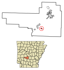
| 주소 | 리버티 애비뉴 & 펜실베이니아 애비뉴 뉴욕 브루클린 11207 | ||
| 자치구 | 브루클린 | ||
| 로캘 | 이스트뉴욕 | ||
| 좌표 | 40°40′28″n 73°53′47″W / 40.674357°N 73.896489°W좌표: 40°40′28″N 73°53′47″W / 40.674357°N 73.896489°W | ||
| 나누기 | B(IND)[1] | ||
| 라인 | IND 풀턴 스트리트 라인 | ||
| 서비스 | A(늦은 밤) C (늦은 밤을 제외한 모든 것) | ||
| 트랜짓 | |||
| 구조 | 지하 | ||
| 플랫폼 | 2면 플랫폼 | ||
| 트랙스 | 4 | ||
| 다른 정보 | |||
| 열린 | 1948년 11월 28일; 전 | ||
| 스테이션 코드 | 185[2] | ||
| 반대- 방향 전근시키다 | 네 | ||
| 교통 | |||
| 2019 | 833,633[3] | ||
| 순위 | 424점[3] 만점에 380점 | ||
| 역승계 | |||
| 다음 북쪽 | 브로드웨이 분기점: A C | ||
| 다음 남쪽 | Van Siclen Avenue: A C | ||
| |||
| |||
| |||
| |||


리버티 애비뉴(Liberty Avenue)는 브루클린 주 이스트뉴욕의 리버티와 펜실베이니아 어벤지스가 교차하는 곳에 위치한 뉴욕시 지하철의 IND Fulton Street Line의 지역역이다. A열차가 운행하는 야간 이외에는 항상 C열차가 운행한다.
리버티 애비뉴 역의 건설은 1938년 핏킨 애비뉴를 따라 풀턴 스트리트 지하철의 4개 역 증설의 일환으로 시작되었다. 역이 대부분 완성되었음에도 불구하고 제2차 세계 대전으로 인한 자금 문제로 작업이 지연되었다. 1946년 11월 풀턴 스트리트 선의 연장선에서 공사가 재개되었고, 풀턴 스트리트 선의 이 부분은 1948년에 개통되었다.
역사
계획

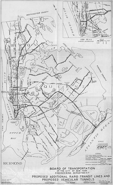
리버티 에비뉴는 원래 계획된 브로드웨이 분기점을 지나 핏킨 에비뉴를 따라 풀턴 스트리트 지하철의 4개 역 연장선의 일부였다.[4][5][6] 풀턴 스트리트 지하철은 브루클린 시내에서 퀸즈 남부까지 시 소유의 인디펜던트 시스템(IND)의 주요 노선이었다.[4] 이 노선은 뉴욕시 교통위원회(BOT)가 1888년부터 운영하던 브루클린-맨해튼 트랜짓 코퍼레이션의 풀턴 스트리트 고가 노선을 대체하기 위해 제안한 것이다.[7]
BOT는 공식적으로 1927년 3월 31일 인디드의 일부로 라파예트 애비뉴에서 앨라배마 애비뉴까지 풀턴 가 아래에 4트랙 지하철을 건설할 계획이라고 발표했다. BOT의 수석 엔지니어인 로버트 리지웨이는 애틀랜틱 애비뉴, 리버티 애비뉴 또는 다른 거리를 경유하여 브루클린과 퀸즈 사이의 경계선까지 노선이 갈 수 있는 경로를 조사하라는 지시를 받았다.[8] 리지웨이는 1929년의 IND 제2 시스템 계획의 일환으로 그랜트 애비뉴의 풀턴 스트리트 하이네이트와 연결하기 위해 리버티 애비뉴를 경유하여 노선을 연장할 것을 제안했다. 이스트 뉴욕을 통과하는 노선의 노선은 1930년 5월 트렉스턴 가의 풀턴 가를 끄고 노먼 플레이스를 거쳐 사유지 아래를 운행한 뒤 리버티 애비뉴 아래를 지나 고가 노선과 연결되는 80번 가까지 운행했다.[7]
1930년대 대공황으로 자금난으로 인해 Rockaway Avenue의 초기 터미널을 지나 추가 공사가 지연되었다. 이것은 1936년부터 연방 작업 진행국 기금에 의해 일시적으로 해결되었다. 1937년 7월 15일, BOT는 Fulton Street Line, Route 110-B번 도로의 연장 계획을 수정하여 뉴욕시 견적 위원회에 제출했다.[7] 이 노선은 펜실베이니아 애비뉴, 핏킨 애비뉴, 린덴 대로, 동부 파크웨이를 따라 건설 중인 브로드웨이-이스트 뉴욕 역에서 퀸즈 남부 106번가까지 연장될 예정이다.[9] 이 경로는 1938년 1월 4일에 BOT에 의해 정식으로 채택되었고, 1938년 1월 20일에 견적 위원회에 의해 채택되었다.[10]
1938년 4월 22일, BOT는 리버티 애비뉴 역이 포함된 펜실베이니아 애비뉴와 브래드포드 스트리트 사이의 노선 구간인 110번 국도, 7번 국도를 건설하는 계약 조건에 대한 공청회를 열었다.[11] 1938년 5월 31일, BOT는 계약자들을 초청하여 이 구간에 입찰하였고, 브래드포드 가에서 애쉬포드 가까지 핏킨 애버뉴를 따라 운행한 110번 도로, 8번 구간에서 입찰하였다.[12] 1938년 7월 21일, BOT는 이 두 구역을 조지 H에 건설하는 계약을 체결했다. 플린 사가 5,220,392달러에 거래.[13]
시공 및 개구부
펜실베니아 주와 핏킨 어벤지스를 따라 로커웨이 애비뉴 동쪽에서 리버티 애비뉴 역을 포함한 크리스탈 스트리트까지 이어지는 부분은 1938년 후반에 공사를 시작했다.[6] 1941년 11월 18일, 제2차 세계 대전 중 자재 부족으로 터널이 완공된 후 구리와 철강, 전력 장비에 대한 방산 산업의 우선순위를 두고 이 노선의 건설은 중단되어야 하고 터널은 막아야 할 것이라고 한다. 동선은 조명, 신호 및 전화를 위해 필요하며, 강철은 전력 장비, 신호 및 기타 설비를 위해 필요할 것이다. 발표 당시 터널 벽을 보강하고, 열린 절단면을 덮은 목재 데크를 포장도로 교체하고, 역을 마무리하는 작업이 진행되고 있었다.[14]
1942년 12월까지 터널 공사가 완료됨에 따라 지하철 연장 공사가 중단되었는데, 브로드웨이-동부 뉴욕 역은 신호 장비가 없어 완공되었지만 운영되지 않았고, 유클리드 애비뉴로 가는 나머지 역은 미완성 조개였다.[7][15][16] 당시 리버티 애비뉴 역이 포함된 구간의 작업은 99% 이상 완료됐지만, 아직 중요한 장비가 설치되지 않아 개통이 불가능했다.[17]
윌리엄 오드여 시장이 획득한 자금의 배분과 전쟁의 종결에 따라 1946년 11월 풀턴 스트리트 선의 연장선에서 공사가 재개되었다.[18][19][20][7] 몇 차례 시험운행 후 1948년 11월 28일 새벽, 유클리드 애비뉴로 가는 노선의 나머지 부분과 함께 역이 일반에 개방되었다.[6][21] 증축 비용은 약 4650만 달러였다.[7][22] 리버티 애비뉴 등 3개 역이 나머지 노선보다 늦게 완공돼 벽타일, 형광등 등 다른 인디안 역과 다른 디자인 특징을 받았다.[7][6][23] 이후 상승된 BMT Fulton Street Line의 펜실베이니아 애비뉴 역의 대체역이 되었으며, 1956년 4월 26일 동부 Fulton과의 연결이 개통되면서 폐쇄되었다.[17][24]
측점 배치도
| G | 거리 수준 | 출구/출입구 |
| M | 메자닌 | 요금 관리, 스테이션 에이전트, 메트로카드 시스템 |
| P 플랫폼 레벨 | 사이드 플랫폼 | |
| 서행 지역 | ← 168번가 방향(광역 분기점) ← 늦은 밤 207번가 방향(브로드웨이 분기점) | |
| 서행 급행열차 | stop 여기서 멈추지 않는다. | |
| 동행 급행열차 | 여기서 멈추지 않는다 → | |
| 동부행 로컬 | | |
| 사이드 플랫폼 | ||

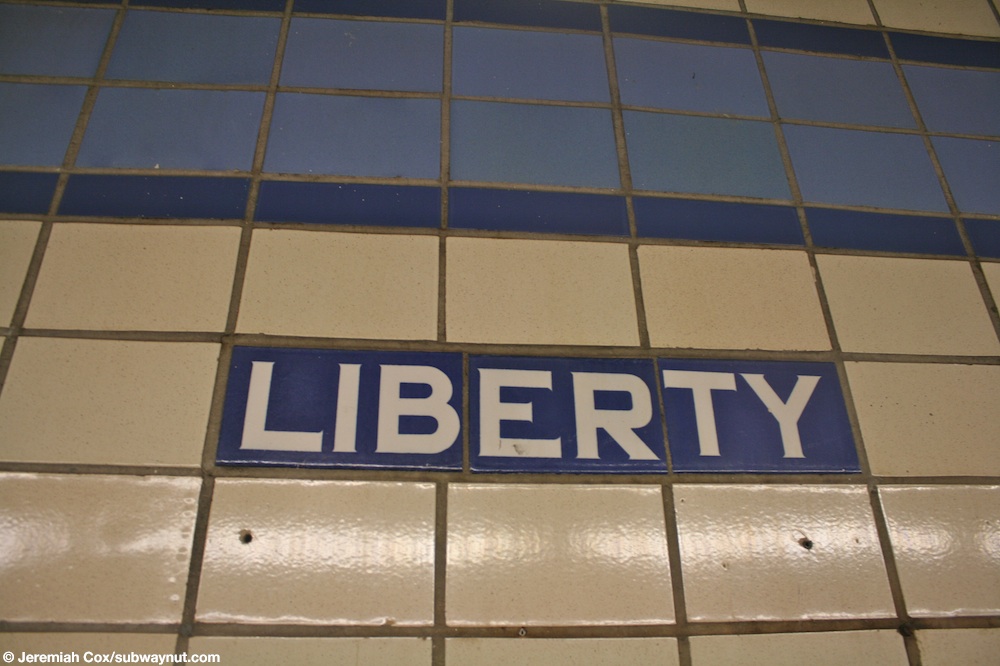
이 지하역에는 2개의 측면 승강장과 4개의 선로가 있다. C열차는 늦은 밤을 제외하고는 항상 이곳에 정차하고 A호선은 주간시간대에 역을 우회하기 위해 2개의 중앙고속철도를 이용한다.[25][26][27] 국부 선로와 급행 선로를 구분하는 교대 기둥에는 흰색 바탕에 검정색으로 "자유 AVE"라고 쓰여 있는 표지판이 있다.[28]
두 플랫폼 벽면 모두 페리윙클 테두리와 어두운 페리윙클 테두리가 있는 트리플 라인이 있고, 어두운 페리윙클 배경과 페리윙클 테두리에 흰색 산세리프 글씨로 "자유 AVE"라고 쓰여 있는 모자이크 명판이 있다.[29][30] 어두운 페리윙클에 흰 글씨로 "자유"라고 쓰여진 작은 타일 자막들이 트림선 아래를 달리고, 같은 스타일의 방향표시가 출구 쪽을 가리키며 일부 이름판 아래에 있다.[31][30] 벽에는 광고가 없고, 계단이 있는 휴게실에는 몇 개의 기둥이 면제되어 있지 않다. 예전에는 계단 아래에 넓은 지역이 있었지만 지금은 보관용으로 사용된다.[28][32]
출구
;_Old_Pay_Phone_Tiles.jpg)
출구는 각 승강장에서 승강장 위 메자닌까지 2개의 계단이 있는 가운데에 있다. 메자닌의 출구는 리버티와 펜실베이니아 어벤지스의 네 모퉁이로 통한다.[33][34] B20과 B83 버스 노선은 역 밖에 정차한다.[35]
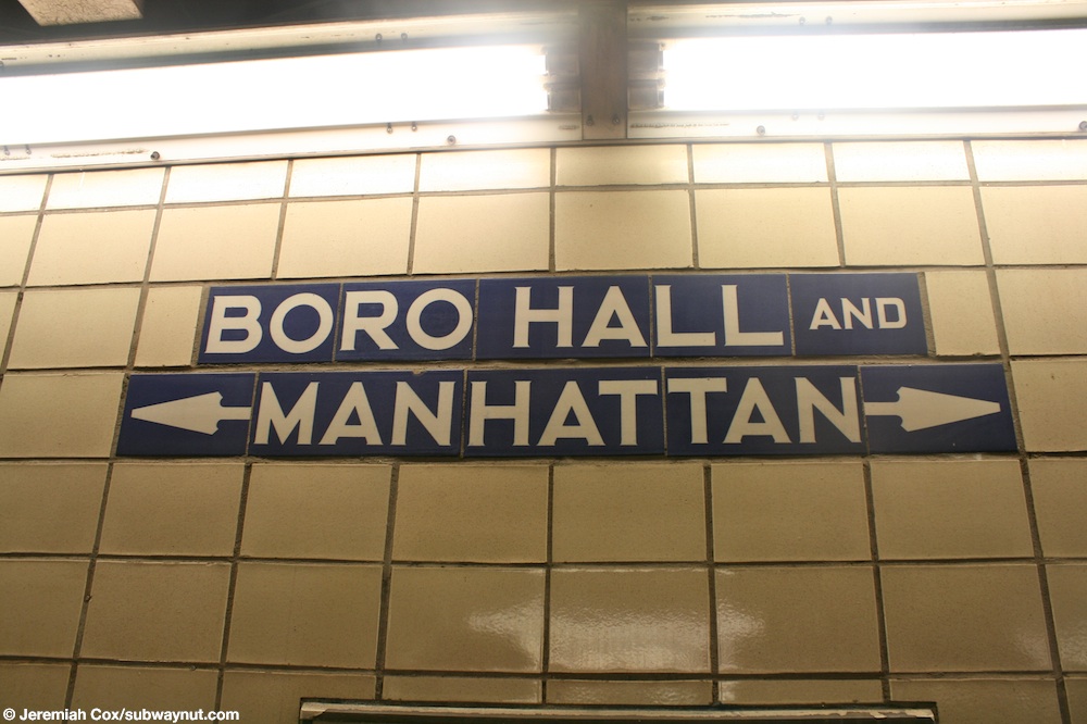
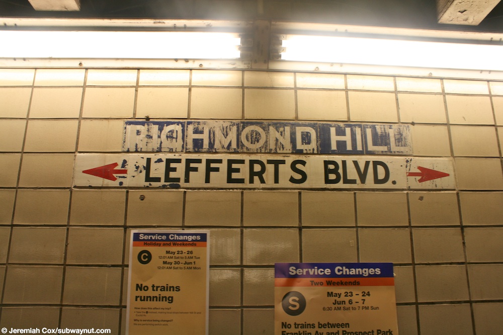
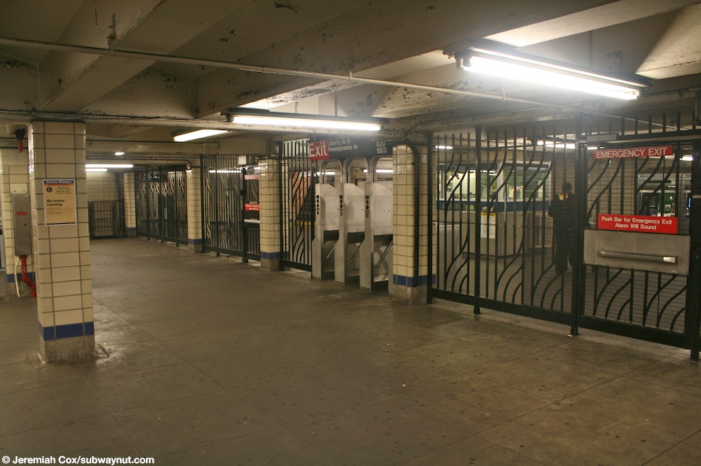
이 역은 풀턴 스트리트 라인의 대부분의 역보다 10년 늦게 완공되었기 때문에 타일링 방식이 다르고 메자닌이 훨씬 좁으며 역의 중심부 위에만 있다. 메자닌에는 "보로 홀과 맨해튼으로"[36]와 "리치몬드 힐과 레퍼츠 BLVD로"를 나타내는 오래된 표지판이 있다.[37] 원래 공중전화 부스가 역에 설치되어 있었기 때문에 "공용 전화"라는 문자로 표시된 알코브도 있다.[19] 폰이 제거되었기 때문에 알코브는 현재 비어 있다.[38] 메자닌의 방향 사이에 무료 크로스오버를 만들 수 있다. 메자닌의 남쪽 끝에는, 3개의 개찰구로 이루어진 둑을 가지고, 역의 유급 구역과 자유 구역을 구분하는 울타리가 있다. 역의 토큰 부스는 개찰구 은행 바로 맞은편에 있다.[39][34]
라이더십
2018년 이 역은 83만9241개의 보드를 달았으며, 424번역 시스템에서 374번째로 가장 많이 사용되는 역이 되었다. 이는 평일 평균 2754명의 승객에 해당한다.[3]
참조
- ^ "Glossary". Second Avenue Subway Supplemental Draft Environmental Impact Statement (SDEIS) (PDF). 1. Metropolitan Transportation Authority. March 4, 2003. pp. 1–2. Archived from the original (PDF) on February 26, 2021. Retrieved January 1, 2021.
- ^ "Station Developers' Information". Metropolitan Transportation Authority. Retrieved June 13, 2017.
- ^ Jump up to: a b "Facts and Figures: Annual Subway Ridership 2014–2019". Metropolitan Transportation Authority. 2020. Retrieved May 26, 2020.
- ^ Jump up to: a b Duffus, R.L. (September 22, 1929). "Our Great Subway Network Spreads Wider; New Plans of Board of Transportation Involve the Building of More Than One Hundred Miles of Additional Rapid Transit Routes for New York" (PDF). The New York Times. Retrieved August 19, 2015.
- ^ Proposed Additional Rapid Transit Lines And Proposed Vehicular Tunnel. Board of Transportation of the City of New York Engineering Department. August 23, 1929. Archived from the original on January 22, 2018. Retrieved January 21, 2018.
- ^ Jump up to: a b c d "Trains Roll on $47,000,000 Fulton St. Subway Extension". Brooklyn Daily Eagle. November 29, 1948. p. 2. Archived from the original on October 28, 2016. Retrieved October 9, 2015 – via Newspapers.com
 .
. - ^ Jump up to: a b c d e f g Raskin, Joseph B. (2013). The Routes Not Taken: A Trip Through New York City's Unbuilt Subway System. New York, New York: Fordham University Press. doi:10.5422/fordham/9780823253692.001.0001. ISBN 978-0-82325-369-2.
- ^ "Fulton Street Subway Route Receives O.K. Approved by Board of Transportation, It Now Goes To Estimate Board". The Brooklyn Citizen. March 31, 1927. Retrieved March 30, 2020 – via Newspapers.com .
- ^ "City Subway Expands". The Brooklyn Daily Eagle. July 11, 1937. Retrieved March 30, 2020 – via Newspapers.com .
- ^ Proceedings. New York City Board of Transportation. 1942. p. 354.
- ^ "Notice of Public Hearing". New York Daily News. April 19, 1938. Retrieved March 30, 2020 – via Newspapers.com .
- ^ Notes - Municipal Reference and Research Center. Municipal Reference and Research Center. 1935. p. 90.
- ^ "Award Contract for 2 Sections Of Fulton Street Subway". The Brooklyn Citizen. July 21, 1938. Retrieved March 30, 2020 – via Newspapers.com .
- ^ "Boro Subway Work Delayed By Priorities: Fulton St. Extension Faces Year's Set-Back Because of Shortage". The Brooklyn Citizen. November 18, 1941. Retrieved March 30, 2020 – via Newspapers.com .
- ^ Blauvelt, Paul (June 9, 1946). "Shortages Snarl $50,000,000 Tube Links". Brooklyn Daily Eagle. p. 21. Retrieved October 9, 2015 – via Newspapers.com .
- ^ "Priorities May Halt Work on Fulton Tube: Vital Defense Materials Are Needed To Complete Spur to Queens County Line". Brooklyn Daily Eagle. November 18, 1941. p. 3. Archived from the original on January 27, 2017. Retrieved August 26, 2016 – via Newspapers.com .
- ^ Jump up to: a b Linder, Bernard (February 2006). "Fulton Street Subway". New York Division Bulletin. Electric Railroader's Association. 49 (2): 2. Archived from the original on September 20, 2016. Retrieved August 27, 2016.
- ^ Jaffe, Alfred (December 6, 1946). "Borough Subway Relief Still 2 or 3 Years Off". Brooklyn Daily Eagle. pp. 1, 5. Archived from the original on October 28, 2016. Retrieved October 9, 2015 – via Newspapers.com .
- ^ Jump up to: a b "Last Word in Subways and Cars for Boro". Brooklyn Daily Eagle. November 23, 1948. p. 8. Archived from the original on October 28, 2016. Retrieved October 9, 2015 – via Newspapers.com .
- ^ Sparberg, Andrew J. (October 2014). From a Nickel to a Token: The Journey from Board of Transportation to MTA. Fordham University Press. ISBN 978-0-8232-6190-1.
- ^ "Fulton Subway Stations Open After All-Night 'Dry Runs'". Brooklyn Daily Eagle. November 28, 1948. Archived from the original on October 28, 2016. Retrieved October 9, 2015 – via Newspapers.com .
- ^ Report for the three and one-half years ending June 30, 1949. New York City Board of Transportation. 1949. hdl:2027/mdp.39015023094926.
- ^ "Last Word in Subways and Cars for Boro". Brooklyn Daily Eagle. November 23, 1948. p. 8. Retrieved October 9, 2015 – via Newspapers.com .
- ^ "First Leg of Rockaways Transit Opened at Cost of $10,154,702" (PDF). The New York Times. April 30, 1956. Retrieved June 29, 2015.
- ^ Dougherty, Peter (2020). Tracks of the New York City Subway 2020 (16th ed.). Dougherty. OCLC 1056711733.
- ^ "A Subway Timetable, Effective November 8, 2020" (PDF). Metropolitan Transportation Authority. Retrieved December 9, 2020.
- ^ "C Subway Timetable, Effective November 8, 2020" (PDF). Metropolitan Transportation Authority. Retrieved December 9, 2020.
- ^ Jump up to: a b Cox, Jeremiah (May 29, 2009). "Looking across the four track subway line at Liberty Avenue, the Euclid Av-bound platform is clearly visible, along with a Liberty Ave sign on a support column". subwaynut.com. Retrieved March 29, 2020.
- ^ Cox, Jeremiah (May 29, 2009). "One the two staircases up to the mezzanine level from the Manhattan-bound platform at Liberty Avenue, notice how modern metal banisters have supplemented the unusual looking original ones". subwaynut.com. Retrieved March 29, 2020.
- ^ Jump up to: a b Cox, Jeremiah (May 29, 2009). "A Liberty Ave name tablet with the directional arrow below it for the next to Liberty Ave". subwaynut.com. Retrieved March 29, 2020.
- ^ Cox, Jeremiah (May 29, 2009). "The Liberty White text on blue-purple tiling beneath the station's trim". subwaynut.com. Retrieved March 29, 2020.
- ^ Cox, Jeremiah (May 29, 2009). "Approaching the center of the Manhattan-bound platform at Liberty Ave, where the area is that has the two narrow staircases up to the mezzanine area and station exit, the platform doubles in width here for the staircases, and there are a couple of tiled station columns". subwaynut.com. Retrieved March 29, 2020.
- ^ "MTA Neighborhood Maps: Liberty Av (C)". mta.info. Metropolitan Transportation Authority. September 2018. Retrieved March 29, 2019.
- ^ Jump up to: a b "East New York Rezoning Proposal Chapter 13: Transportation" (PDF). nyc.gov. New York City Department of City Planning. February 12, 2016. p. 13-49, Figure 13-24a. Retrieved March 29, 2020.
- ^ "Brooklyn Bus Map" (PDF). Metropolitan Transportation Authority. October 2020. Retrieved December 1, 2020.
- ^ Cox, Jeremiah (May 29, 2009). "Original tiling at the top of the two platform staircases where they meet on the mezzanine spelling out 'Boro Hall and Manhattan'". subwaynut.com. Retrieved March 29, 2020.
- ^ Cox, Jeremiah (May 29, 2009). "The tiled signs above the two staircases to the Euclid Avenue-bound station are another example of signs for destinations the subway hasn't really reached, the top one is tiled for Richmond Hill, although it looks like all the paint that was ment to say something else has chipped off. The bottom sign is correct but has been painted on over tiles and says Lefferts Blvd". subwaynut.com. Retrieved March 29, 2020.
- ^ Cox, Jeremiah (May 29, 2009). "A tiled sign that says Public Telephones above a small indentation in wall where a phone probably was once upon a time, this sign is currently meaningless". subwaynut.com. Retrieved March 29, 2020.
- ^ Cox, Jeremiah (May 29, 2009). "The adequate but not far too large mezzanine area within fare control at liberty Ave". subwaynut.com. Retrieved March 29, 2020.
외부 링크
| 위키미디어 커먼즈에는 리버티 애비뉴(IND Fulton Street Line)와 관련된 미디어가 있다. |
- nycsubway.org – IND Fulton Street Line: Liberty Avenue
- 스테이션 리포터 - C 트레인
- 지하철 너트 — 리버티 애비뉴 픽처
- Google 지도 스트리트 뷰에서 Liberty Avenue 입구
- Google 지도 스트리트 뷰의 플랫폼

