프로쿠플제
Prokuplje프로쿠플제 Прокупље (세르비아) | |
|---|---|
 Prokuplje - 이미지 콜라주:종합병원, 라틴교회, 시청, 법원 건물 상의 동상, 제1차 세계대전 영웅 기념비, 국립 토플리카 박물관. | |
 문장 | |
 세르비아 내 프로쿠플제 시 소재지 | |
| 좌표:43°141010nN 21°35′25″e/43.23611°N 21.59028°E좌표: 43°141010nN 21°35 †25 †E / 43.23611°N 21.59028°E / | |
| 나라 | |
| 지역 | 세르비아 남부 및 동부 |
| 구 | 토플리카 |
| 도시 현황 | 2018년 6월 |
| 결산 | 107 |
| 정부 | |
| • 시장 | 알렉산다르 시모노비치 (SNS) |
| 지역 | |
| • 도시형 | 20.96km2(8.09평방마일) |
| • 관리 | 759km2(293평방마일) |
| 승진 | 273 m (896 피트) |
| 인구. (2011년 인구조사)[2] | |
| • 도시형 | 27,333 |
| • 도시 밀도 | 1,300/km2 (3,400/140 mi) |
| • 관리 | 44,419 |
| • 관리 밀도 | 59/km2 (150/150 mi) |
| 시간대 | UTC+1(CET) |
| • 여름 (DST) | UTC+2(CEST) |
| 우편번호 | 18400 |
| 지역번호 | +381(0)27 |
| 자동차 번호판 | PK |
| 웹 사이트 | www |
프로쿠플예(세르비아 키릴어: ǒоupupup]]]]]]]]]]]]]]]]]]])는 세르비아 남부 토플리카 구의 행정 중심지이자 도시이다.2011년 인구 조사에 따르면, 도시 도시 지역의 인구는 27,333명이고, 행정 구역은 44,419명이다.
프로쿠플제는 세르비아의 로마 유적지 중 하나이다.그 마을은 오스만 통치 기간 동안 우르귀프라고 알려졌고 1878년 세르비아 왕국에 합병되었다.
지리
프로쿠플제는 블라체, 쿠르숨리야, 보이크, 지토라자, 메로시나, 알렉산드르나크, 크루셰바치의 자치체 사이에 위치한다.
기후.
Prokupleje는 습한 아열대 기후(Köppen 기후 분류: Cwb)에 가까운 따뜻한 여름 지중해성 기후(Köppen 기후 분류: Cfa)를 가지고 있습니다.
| Prokuplje의 기후 데이터 | |||||||||||||
|---|---|---|---|---|---|---|---|---|---|---|---|---|---|
| 달 | 1월 | 2월 | 마루 | 에이프릴 | 그럴지도 모른다 | 준 | 줄 | 8월 | 9월 | 10월 | 11월 | 12월 | 연도 |
| 평균 최고 °C(°F) | 4.8 (40.6) | 7.2 (45.0) | 12.6 (54.7) | 18.8 (65.8) | 24.8 (76.6) | 27.2 (81.0) | 30.2 (86.4) | 29.0 (84.2) | 26.2 (79.2) | 19.2 (66.6) | 11.7 (53.1) | 6.0 (42.8) | 18.1 (64.7) |
| 일평균 °C(°F) | 1.8 (35.2) | 3.7 (38.7) | 8.2 (46.8) | 12.7 (54.9) | 18.3 (64.9) | 21.2 (70.2) | 22.6 (72.7) | 21.6 (70.9) | 19.7 (67.5) | 13.3 (55.9) | 9.6 (49.3) | 2.8 (37.0) | 13.0 (55.3) |
| 평균 최저 °C(°F) | −2.0 (28.4) | −0.6 (30.9) | 3.2 (37.8) | 8.6 (47.5) | 12.8 (55.0) | 14.8 (58.6) | 18.2 (64.8) | 17.8 (64.0) | 14.7 (58.5) | 9.6 (49.3) | 5.9 (42.6) | −0.3 (31.5) | 8.6 (47.4) |
| 평균 강수량 mm(인치) | 76 (3.0) | 63 (2.5) | 52 (2.0) | 45 (1.8) | 38 (1.5) | 36 (1.4) | 29 (1.1) | 30 (1.2) | 38 (1.5) | 49 (1.9) | 60 (2.4) | 57 (2.2) | 573 (22.5) |
| 출처 : Climate-Data.org | |||||||||||||
역사와 고고학
신석기 시대와 구리 시대
초기 정착의 흔적은 마시나(지트니포톡 인근), 프로쿠플제(돈자 트르나바 마을)에서 서쪽으로 6km(4마일) 떨어진 카볼락, 돈자브레시니카 마을 남쪽 경사면의 정착지 등 신석기시대 유적지에서 찾을 수 있다.프로쿠플제에서 서쪽으로 19km(12마일) 떨어진 토플리카 강의 왼쪽 [4]둑에 있는 프로쿠플제에서 쿠르숨리야로 [citation needed]가는 도로 왼쪽에 위치한 플로치니크 유적지에 빈차 시대가 보존되어 있다.플로치니크는 벨로보데와 함께 세르비아의 두 개의 빈차 문화 유적지 중 하나이며 (2014년 현재) 구리 [4]제련의 증거를 가장 빨리 생산한 곳으로 여겨지고 있다.점령 기간은 벨로보데가 기원전 5350-4650년, 플로치닉이 기원전 5200-4650년 사이이며, 플로치닉은 지금까지 세계에서 [4]두 번째로 오래된 구리 제련소이다.금속 가공의 출현에 대한 두 가지 이론이 있다: 제련 기술은 오직 한 지역, 현재 이란 남부의 비옥한 초승달 근처에서 발견되었고 전 세계적으로 그곳에서 배출되었다거나, 혹은 세르비아와 불가리아의 빈차 문화 지역이 그들 중 하나이고, 다른 장소에서 독립적으로 일어났다.가장 오래된 연구 [5]대상일 수도 있어요2008년 10월, 플로치니크의 세르비아 고고학자들은 7,500년 된 것으로 추정되는 구리 도끼를 발견했는데, 이것은 이전에 구리 시대의 시작이라고 여겨졌던 것보다 500년에서 800년 더 오래되었고, 인간이 금속을 사용한 것이 이전에 [6][7]믿었던 것보다 더 오래되었다는 것을 암시한다.
고전 고대
농경지 빈차 정착촌은 신흥 트라키아인들과 기원전 279년 켈트족 스코르디시족에 의해 대체되었다.라틴 교회가 발견한 도자기 조각들은 그리스로 [citation needed]향하던 부족들의 이동 흔적이다.
기원전 73년에서 75년 사이에, 로마인들이 그 지역의 부족들을 정복한 후, 세르비아의 이 지역은 로마의 모에시아 지방의 일부가 되었다.그 당시 그 정착지는 함므음 또는 하메오라고 알려졌는데, 이것은 가장 오래된 보존된 이름이었다.그것은 발칸반도의 중앙과 아드리아해를 연결하는 도로인 로마 비아 밀리터리스에 위치해 근처 나이수스(니시)[citation needed]를 통과했다.2008년 7월에 로마의 주요 스파가 [8]발굴되었다.
기원후 4세기 말에, 로마 제국이 분열되었을 때, 토플리카 지역은 동로마 또는 비잔틴 제국의 일부가 되었다.그곳은 콤플로스 또는 콤블로스(마을 마을)로 알려지게 되었다.몇몇 역사학자들은 콤플로스가 유스티니아누스 황제에 의해 재건되었다고 믿는다.

로마 목욕탕 유적

라틴 교회

라틴 교회


중세 시대
남세르비아인들이 6세기에 이 지역에 처음 정착했을 때, 이 도시는 콤플로스로 알려져 있었다.
9-11 세기와 13세기 동안 오늘날의 프로쿠플제의 영토는 불가리아 제국의 일부였다.[9][10][11][12][13]
도시의 이름은 "성곽의 요새"에서 따왔다. Procopios, 1395년에 [14]처음 언급되었다.오스만 제국은 세르비아를 정복하는 동안 그 도시를 점령했지만, 1444년 체게드 [15]조약에 따라 그 도시를 반환해야 했다.
오스만 통치
15-17세기
1454년 프로쿠플제는 오스만 제국에 포위되었고 이후 423년 동안 오스만 제국이 통치하는 동안 그곳의 이름은 우르쿠브 또는 오크루브였다.니시의 [16]산자크의 일부였다.
오스만 통치 기간 동안, 16세기에서 17세기 사이, 이 마을의 중요성은 크루셰바츠, 스탈락, 레스코바츠 같은 이 지역의 다른 마을들과 비슷하게 증가했습니다.프로쿠플제는 두브로브니크와의 무역 관계를 통해 [17]번창했다.
1689-1682: 전쟁과 민족 변화
터키 전쟁(1683-1699년) 동안, 이 지역에서 진격하던 오스트리아군을 지원하기 위해 기독교계 세르비아인들의 대규모 지역 반란이 있었다.프로쿠플제는 1689년 오스트리아군과 세르비아 민병대에 의해 점령되었지만, 오스만의 반격 이후 합스부르크의 안토니예 즈노리치 대령의 반대 [17]명령에도 불구하고 1690년 오스트리아 후퇴 중에 마을이 불탔다.오스트리아군을 지원했던 세르비아인들은 철수 후 점점 [18]더 많은 이주를 시작했고 무슬림 알바니아인들의 [19]이주가 증가하였다.

아르바나슈카와 짜케와 같은 지명은 중세 [20][21]시대로 거슬러 올라가는 토플리카와 남부 모라바 지역에 알바니아인의 존재를 보여준다.토플리카 계곡의 시골 지역과 인접한 반산맥 내륙은 오스만 통치 기간 동안 이슬람 알바니아계 인구가 밀집한 반면, 이들 지역의 세르비아인들은 강 하구와 산비탈 근처에 살았고, 두 민족 모두 남모라바 강 [22][23]유역의 다른 지역에 살았다.토플리카 지역은 알바니아계가[24] 다수를 차지했고 프로쿠플제 [25]마을도 마찬가지였다.
1877-1878년 동안, 이 알바니아인들은 오늘날 인종 [29]청소로 특징지어지는 방식으로[26][27][28] 세르비아 군대에 의해 추방되었다.1878년 초 지방 당국은 당시 교육부 장관이었던 알림페 바실예비치를 위해 보고서를 작성했다.131개의 마을이 있었으며 세르비아인 주택 1,485채와 무슬림 주택 1,553채가 있었다.폭설로 인해 12개 마을이 미등록 상태였지만 이 버려진 마을 주민들은 모두 알바니아인이었다.따라서 마을과 관련된 주택 수는 119개 마을밖에 되지 않는다.세르비아군의 [30]도착으로 프로쿠플예 지역의 119개 마을에서 약 1만1437명의 알바니아인들이 집을 떠난 것으로 추정된다.
현대 세르비아 및 유고슬라비아(1877-)
1877년, 세르비아군에 의해 토플리카 지역 전체가 오스만 제국으로부터 점령되었고, 1877년 12월 19일 프로쿠플레가 주인이 바뀌었다.1878년 베를린 회의는 그 도시와 넓은 지역을 세르비아의 일부로 인정했다.
1929년부터 1941년까지 프로쿠플제는 유고슬라비아 왕국의 모라바 바노비나의 일부였다.제1차 세계대전, 제2차 세계대전 때는 전멸했지만 전후에는 공업도시로 발전했다.

2018년 6월 프로쿠플제는 [31]보르와 함께 도시 지위를 얻었다.
인구 통계
| 연도 | Pop. | ±% p.a. |
|---|---|---|
| 1948 | 59,292 | — |
| 1953 | 62,614 | +1.10% |
| 1961 | 60,075 | −0.52% |
| 1971 | 57,315 | −0.47% |
| 1981 | 56,256 | −0.19% |
| 1991 | 52,969 | −0.60% |
| 2002 | 48,501 | −0.80% |
| 2011 | 44,419 | −0.97% |
| 출처: | ||
2011년에 실시된 마지막 공식 인구 조사에 따르면, 프로쿠플제에는 44,419명의 주민이 살고 있다.인구의 61.5%가 도시에 살고 있다.프로쿠플제는 평균 회원수 300여 가구 1만4814가구,[33] 주택수는 2만2898가구다.
프로쿠플제의 종교 구조는 주로 세르비아 정교회(41,494개)이며, 무슬림(289개), 무신론자(122개), 가톨릭(76개) [34]등 소수 민족이 있다.인구의 대부분은 세르비아어를 사용한다.[34]
성별과 평균 [34]연령에 따른 인구 구성:
- 남성 - 22,056(40.90세) 및
- 여성 - 22,363(43.65세).
중등교육을 받은 시민(15세 이상)은 1만7777명(47.1%), 고등교육을 받은 시민은 5002명(13.3%)이다.고학력자 중 2700명(7.2%)이 [35]대학교육을 받고 있다.
민족
프로쿠플제 인구의 대부분은 세르비아계이다.도시의 민족 구성:
| 민족 집단 | 인구. | % |
|---|---|---|
| 세르비아인 | 40,936 | 92.16% |
| 로마 | 2,145 | 4.83% |
| 몬테네그로인 | 113 | 0.25% |
| 로마인 | 75 | 0.17% |
| 마케도니아인 | 74 | 0.17% |
| 크로아츠 | 35 | 0.08% |
| 고라니 | 24 | 0.05% |
| 다른이들 | 1,017 | 2.29% |
| 총 | 44,419 |
경제.
프로쿠플제는 경제가 취약해 대부분의 취업자들이 공공 부문에서 일하고 있다.2009년 Leoni Wiring Systems 남동쪽은 Prokuplje에 공장을 열었으며,[36] 2013년 현재 약 1,750명의 직원을 고용하고 있습니다.
다음 표는 핵심 활동(2018년 기준)[37]당 법인에서 고용된 총 등록 인원의 미리보기입니다.
| 활동 | 총 |
|---|---|
| 농림어업 | 107 |
| 채굴 및 채석 | 1 |
| 제조업 | 4,575 |
| 전기, 가스, 증기 및 에어컨 공급 | 95 |
| 급수; 하수, 폐기물 관리 및 복구 활동 | 353 |
| 건설 | 364 |
| 도소매업, 자동차 및 오토바이 수리업 | 1,441 |
| 수송 및 보관 | 285 |
| 숙박 및 음식 서비스 | 290 |
| 정보 및 커뮤니케이션 | 96 |
| 재무 및 보험 활동 | 96 |
| 부동산 활동 | 6 |
| 전문, 과학 및 기술 활동 | 265 |
| 관리 및 지원 서비스 활동 | 101 |
| 행정 및 방위, 사회보장 의무화 | 986 |
| 교육 | 795 |
| 의료 및 사회 복지 사업 | 1,184 |
| 예술, 엔터테인먼트 및 레크리에이션 | 238 |
| 기타 서비스 활동 | 144 |
| 개인 농업 종사자 | 204 |
| 총 | 11,627 |
갤러리

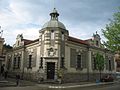
프로쿠플제 시청

시청
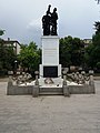
도심 기념비
국립박물관

지방 법원
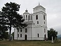
콘젤리 교회
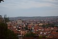
시티 파노라마
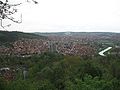
시티 파노라마
라스토브니차 호

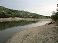
토플리카 강


국제 관계
트윈타운 – 자매도시
Prokuplje는 다음과 같은 기능을 갖추고 있습니다.
「 」를 참조해 주세요.
레퍼런스
- ^ "Municipalities of Serbia, 2006". Statistical Office of Serbia. Retrieved 2010-11-28.
- ^ "2011 Census of Population, Households and Dwellings in the Republic of Serbia: Comparative Overview of the Number of Population in 1948, 1953, 1961, 1971, 1981, 1991, 2002 and 2011, Data by settlements" (PDF). Statistical Office of Republic Of Serbia, Belgrade. 2014. ISBN 978-86-6161-109-4. Retrieved 2014-06-27.
- ^ "Climate: Prokuplje, Serbia". Climate-Data.org. Retrieved 14 February 2018.
- ^ a b c Radivojević, Miljana; Kuzmanović-Cvetković, Julka (2014). "Copper minerals and archaeometallurgical materials from the Vinča culture sites of Belovode and Pločnik: Overview of the evidence and new data" (PDF). Starinar (64): 7–30. doi:10.2298/STA1464007R. Retrieved 27 June 2020.
- ^ Bower, Bruce (25–26 June 2010). "Serbian site may have hosted first copper makers". Science News. Retrieved 27 June 2020 – via The Archaeology News Network.
- ^ "Ancient axe find suggests Copper Age began earlier than believed". thaindian.com. Retrieved 9 April 2018.
- ^ "Stone Pages Archaeo News: Ancient metal workshop found in Serbia". www.stonepages.com. Retrieved 9 April 2018.
- ^ "Archived copy". Archived from the original on 2011-06-07. Retrieved 2009-07-21.
{{cite web}}: CS1 maint: 제목으로 아카이브된 복사(링크) - ^ Ivanisheviec 2013, 페이지 : 없음: 도움말)
- ^ "Euratlas Periodis Web - Map of Europe in Year 900".
- ^ Fine, John V. A.; Fine, John Van Antwerp (29 December 1991). The Early Medieval Balkans: A Critical Survey from the Sixth to the Late Twelfth Century. University of Michigan Press. ISBN 978-0472081493. Retrieved 29 December 2017 – via Google Books.
- ^ 중세 후기 발칸 반도, 페이지 48
- ^ 중세 후기 발칸 반도, 54페이지
- ^ Konstantin Jirecek (1911), Geschichte der Serben, vol. 1, p. 221
- ^ Gjuro Szabo (1924), "Prokuplje", Narodna enciklopedija, vol. 3, pp. 706–707
- ^ Godišnjak grada Beograda. Museum of the Belgrade. 1977. p. 116. Retrieved 11 July 2011.
- ^ a b Kostić, Radoje. "Нишка Епархија у првој половини 18. века". Niš: Istorijski Arhiv Niš. Archived from the original on 4 September 2011. Retrieved 14 December 2011.
Прокупље је запалио пуковник Антоније Знорић приликом повлачења 1690. године
- ^ Shaw, Stanford J.; Shaw, Ezel Kural (1976). History of the Ottoman Empire and Modern Turkey: Volume 1, Empire of the Gazis: The Rise and Decline of the Ottoman Empire 1280-1808. Cambridge University Press. pp. 219–221. ISBN 9780521291637. Retrieved 12 January 2019.
- ^ Rudić, Vujadin (1992). Population of Prokuplje. Belgrade: Ethnographic institute, SANU. pp. 11–12. ISBN 978-86-7587-011-1.
- ^ Uka, Sabit (2004). Jeta dhe veprimtaria e shqiptarëve të Sanxhakut të Nishit deri më 1912 [Life and activity of Albanians in the Sanjak of Nish up to 1912]. Verana. pp. 244–245. ISBN 9789951864527.
Eshtë, po ashtu, me peshë historike një shënim i M. Gj Miliçeviqit, i cili bën fjalë përkitazi me Ivan Begun. Ivan Begu, sipas tij ishte pjesëmarrës në Luftën e Kosovës 1389. Në mbështetje të vendbanimit të tij, Ivan Kullës, fshati emërtohet Ivan Kulla (Kulla e Ivanit), që gjendet në mes të Kurshumlisë dhe Prokuplës. M. Gj. Miliçeviqi thotë: "Shqiptarët e ruajten fshatin Ivan Kullë (1877–1878) dhe nuk lejuan që të shkatërrohet ajo". Ata, shqiptaret e Ivan Kullës (1877–1878) i thanë M. Gj. Miliçeviqit se janë aty që nga para Luftës se Kosovës (1389). [12] Dhe treguan që trupat e arrave, që ndodhen aty, ata i pat mbjellë Ivan beu. Atypari, në malin Gjakë, nodhet kështjella që i shërbeu Ivanit (Gjonit) dhe shqiptarëve për t’u mbrojtur. Aty ka pasur gjurma jo vetëm nga shekulli XIII dhe XIV, por edhe të shekullit XV ku vërehen gjurmat mjaft të shumta toponimike si fshati Arbanashka, lumi Arbanashka, mali Arbanashka, fshati Gjakë, mali Gjakë e tjerë. [13] Në shekullin XVI përmendet lagja shqiptare Pllanë jo larg Prokuplës. [14] Ne këtë shekull përmenden edhe shqiptarët katolike në qytetin Prokuplë, në Nish, në Prishtinë dhe në Bulgari.[15].... [12] M. Đj. Miličević. Kralevina Srbije, Novi Krajevi. Beograd, 1884: 354. "Kur flet mbi fshatin Ivankullë cekë se banorët shqiptarë ndodheshin aty prej Betejës së Kosovës 1389. Banorët e Ivankullës në krye me Ivan Begun jetojnë aty prej shek. XIV dhe janë me origjinë shqiptare. Shqiptarët u takojnë të tri konfesioneve, por shumica e tyre i takojnë atij musliman, mandej ortodoks dhe një pakicë i përket konfesionit katolik." [13] Oblast Brankovića, Opširni katastarski popis iz 1455 godine, përgatitur nga M. Handžic, H. Hadžibegić i E. Kovačević, Sarajevo, 1972: 216. [14] Skënder Rizaj, T,K "Perparimi" i vitit XIX, Prishtinë 1973: 57.[15] Jovan M. Tomić, O Arnautima u Srbiji, Beograd, 1913: 13. [It is, as such, of historic weight in a footnote of M. Đj. Miličević, who says a few words regarding Ivan Beg. Ivan Beg, according to him participated in the Battle of Kosovo in 1389. In support of his residence, Ivan Kula, the village was named Ivan Kula (Tower of Ivan), located in the middle of Kuršumlija and Prokuple. M. Đj. Miličević says: "Albanians safeguarded the village Ivan Kula (1877–1878) and did not permit its destruction." Those Albanians of Ivan Kulla (1877–1878) told M.Đj. Miličević that they have been there since before the Kosovo War (1389). And they showed where the bodies of the walnut trees were, that Ivan Bey had planted. Then there to Mount Đjake, is the castle that served Ivan (John) and Albanians used to defend themselves. There were traces not only from the XIII and XIV centuries, but the XV century where we see fairly multiple toponymic traces like the village Arbanaška, river Arbanaška, mountain Arbanaška, village Đjake, mountain Đjake and others. In the sixteenth century mentioned is the Albanian neighborhood Plana not far from Prokuple. [14] In this century is mentioned also Catholic Albanians in the town of Prokuplje, Niš, Priština and in Bulgaria.[15].... [12] M. Đj. Miličević. Kralevina Srbije, Novi Krajevi. Beograd, 1884: 354. When speaking about the village Ivankula, its residents state that Albanians were there from the Battle of Kosovo in 1389. Residents of Ivankula headed by Ivan Beg are living there since the XIV century and they are of Albanian origin. Albanians belong to three religions, but most of them belong to the Muslim one, after Orthodoxy and then a minority belongs to the Catholic confession. [13] Oblast Brankovića, Opširni katastarski popis iz 1455 godine, përgatitur nga M. Handžic, H. Hadžibegić i E. Kovačević, Sarajevo, 1972: 216. [14] Skënder Rizaj, T,K "Perparimi" i vitit XIX, Prishtinë 1973: 57. [15] Jovan M. Tomić, O Arnautima u Srbiji, Beograd, 1913: 13.]
- ^ Geniş, Şerife; Maynard, Kelly Lynne (2009). "Formation of a Diasporic Community: The History of Migration and Resettlement of Muslim Albanians in the Black Sea Region of Turkey". Middle Eastern Studies. 45 (4): 556–557. doi:10.1080/00263200903009619. S2CID 143742189.
Using secondary sources, we establish that there have been Albanians living in the area of Nish for at least 500 years, that the Ottoman Empire controlled the area from the fourteenth to nineteenth centuries which led to many Albanians converting to Islam, that the Muslim Albanians of Nish were forced to leave in 1878, and that at that time most of these Nishan Albanians migrated south into Kosovo, although some went to Skopje in Macedonia. ; p. 557. It is generally believed that the Albanians in Samsun Province are the descendants of the migrants and refugees from Kosovo who arrived in Turkey during the wars of 1912–13. Based on our research in Samsun Province, we argue that this information is partial and misleading. The interviews we conducted with the Albanian families and community leaders in the region and the review of Ottoman history show that part of the Albanian community in Samsun was founded through three stages of successive migrations. The first migration involved the forced removal of Muslim Albanians from the Sancak of Nish in 1878; the second migration occurred when these migrants’ children fled from the massacres in Kosovo in 1912–13 to Anatolia; and the third migration took place between 1913 and 1924 from the scattered villages in Central Anatolia where they were originally placed to the Samsun area in the Black Sea Region. Thus, the Albanian community founded in the 1920s in Samsun was in many ways a reassembling of the demolished Muslim Albanian community of Nish…. Our interviews indicate that Samsun Albanians descend from Albanians who had been living in the villages around the city of Nish… pp. 557–558. In 1690 much of the population of the city and surrounding area was killed or fled, and there was an emigration of Albanians from the Malësia e Madhe (North Central Albania/Eastern Montenegro) and Dukagjin Plateau (Western Kosovo) into Nish.
- ^ 야고디치 1998년 4, 9, 32~42, 45~61항
- ^ Luković, Miloš (2011). "Development of the Modern Serbian state and abolishment of Ottoman Agrarian relations in the 19th century". Český Lid. Institute of Ethnology, Czech Academy of Sciences. 98 (3): 298. JSTOR 42640413.
During the second war (December 1877 — January 1878) the Muslim population fled towns (Vranya (Vranje), Leskovac, Ürgüp (Prokuplje), Niş (Niš), Şehirköy (Pirot), etc.) as well as rural settlements where they comprised ethnically compact communities (certain parts of Toplica, Jablanica, Pusta Reka, Masurica and other regions in the South Morava River basin). At the end of the war these Muslim refugees ended up in the region of Kosovo and Metohija, in the territory of the Ottoman Empire, following the demarcation of the new border with the Principality of Serbia. [38] [38] On Muslim refugees (muhaciri) from the regions of southeast Serbia, who relocated in Macedonia and Kosovo, see Trifunovski 1978, Radovanovič 2000.
- ^ Bataković, Dušan T. (2007). "(title behind paywall/June 2020)". Kosovo and Metohija: Living in the Enclave. Special editions, volume 96. Serbian Academy of Sciences and Arts, Institute for Balkan Studies: 35. ISBN 9788671790529. ISSN 0352-1869. Retrieved 22 June 2011.
Prior to the Second Serbo-Ottoman War (1877-78), Albanians were the majority population in some areas of Sanjak of Nis (Toplica region), while from the Serb majority district of Vranje Albanian-inhabited villages were emptied after the 1877-1878 war
- ^ Manaj, Ramë; Osmani, Jusuf; Mekaj, Shpresa; Aliu, Bekim (2018). THE EXPULSION OF ALBANIANS FROM SANJAK OF NISH 1877/78. Prishtinë: STATE AGENCY OF KOSOVO ARCHIVES. p. 22.
- ^ Turović, Dobrosav (2002). Gornja Jablanica, Kroz istoriju. Beograd Zavičajno udruženje. pp. 87–89.
- ^ Uka, Sabit (2004). Gjurmë mbi shqiptarët e Sanxhakut të Nishit deri më 1912 [Traces on Albanians of the Sanjak of Nish up to 1912]. Verana. p. 155. ISBN 9789951864527.
Në kohët e sotme fshatra të Jabllanicës, të banuara kryesisht me shqiptare, janë këto: Tupalla, Kapiti, Gërbavci, Sfirca, Llapashtica e Epërrne. Ndërkaq, fshatra me popullsi te përzier me shqiptar, malazezë dhe serbë, jane këto: Stara Banja, Ramabanja, Banja e Sjarinës, Gjylekreshta (Gjylekari), Sijarina dhe qendra komunale Medvegja. Dy familje shqiptare ndeshen edhe në Iagjen e Marovicës, e quajtur Sinanovë, si dhe disa familje në vetë qendrën e Leskovcit. Vllasa është zyrtarisht lagje e fshatit Gërbavc, Dediqi, është lagje e Medvegjes dhe Dukati, lagje e Sijarinës. Në popull konsiderohen edhe si vendbanime të veçanta. Kështu qendron gjendja demografike e trevës në fjalë, përndryshe para Luftës se Dytë Botërore Sijarina dhe Gjylekari ishin fshatra me populisi të perzier, bile në këtë te fundit ishin shumë familje serbe, kurse tani shumicën e përbëjnë shqiptarët. [In contemporary times, villages in the Jablanica area, inhabited mainly by Albanians, are these: Tupale, Kapiti, Grbavce, Svirca, Gornje Lapaštica. Meanwhile, the mixed villages populated by Albanians, Montenegrins and Serbs, are these: Stara Banja, Ravna Banja, Sjarinska Banja, Đulekrešta (Đulekari) Sijarina and the municipal center Medveđa. Two Albanian families are also encountered in the neighborhood of Marovica called Sinanovo, and some families in the center of Leskovac. Vllasa is formally a neighborhood of the village Grbavce, Dedići is a neighborhood of Medveđa and Dukati, a neighborhood of Sijarina. So this is the demographic situation in question that remains, somewhat different before World War II as Sijarina and Đulekari were villages with mixed populations, even in this latter settlement were many Serb families, and now the majority is made up of Albanians.]
- ^ Blumi, Isa (2013). Ottoman refugees, 1878–1939: migration in a post-imperial world. A&C Black. p. 50. ISBN 9781472515384.
As these Niš refugees waited for acknowledgment from locals, they took measures to ensure that they were properly accommodated by often confiscating food stored in towns. They also simply appropriated lands and began to build shelter on them. A number of cases also point to banditry in the form of livestock raiding and "illegal" hunting in communal forests, all parts of refugees’ repertoire... At this early stage of the crisis, such actions overwhelmed the Ottoman state, with the institution least capable of addressing these issues being the newly created Muhacirin Müdüriyeti... Ignored in the scholarship, these acts of survival by desperate refugees constituted a serious threat to the established Kosovar communities. The leaders of these communities thus spent considerable efforts lobbying the Sultan to do something about the refugees. While these Niš muhacir would in some ways integrate into the larger regional context, as evidenced later, they, and a number of other Albanian-speaking refugees streaming in for the next 20 years from Montenegro and Serbia, constituted a strong opposition block to the Sultan’s rule."; p.53. "One can observe that in strategically important areas, the new Serbian state purposefully left the old Ottoman laws intact. More important, when the state wished to enforce its authority, officials felt it necessary to seek the assistance of those with some experience, using the old Ottoman administrative codes to assist judges make rulings. There still remained, however, the problem of the region being largely depopulated as a consequence of the wars... Belgrade needed these people, mostly the landowners of the productive farmlands surrounding these towns, back. In subsequent attempts to lure these economically vital people back, while paying lip-service to the nationalist calls for "purification," Belgrade officials adopted a compromise position that satisfied both economic rationalists who argued that Serbia needed these people and those who wanted to separate "Albanians" from "Serbs." Instead of returning to their "mixed" villages and towns of the previous Ottoman era, these "Albanians," "Pomoks," and "Turks" were encouraged to move into concentrated clusters of villages in Masurica, and Gornja Jablanica that the Serbian state set up for them. For this "repatriation" to work, however, authorities needed the cooperation of local leaders to help persuade members of their community who were refugees in Ottoman territories to "return." In this regard, the collaboration between Shahid Pasha and the Serbian regime stands out. An Albanian who commanded the Sofia barracks during the war, Shahid Pasha negotiated directly with the future king of Serbia, Prince Milan Obrenović, to secure the safety of those returnees who would settle in the many villages of Gornja Jablanica. To help facilitate such collaborative ventures, laws were needed that would guarantee the safety of these communities likely to be targeted by the rising nationalist elements infiltrating the Serbian army at the time. Indeed, throughout the 1880s, efforts were made to regulate the interaction between exiled Muslim landowners and those local and newly immigrant farmers working their lands. Furthermore, laws passed in early 1880 began a process of managing the resettlement of the region that accommodated those refugees who came from Austrian-controlled Herzegovina and from Bulgaria. Cooperation, in other words, was the preferred form of exchange within the borderland, not violent confrontation.
- ^ Müller, Dietmar (2009). "Orientalism and Nation: Jews and Muslims as Alterity in Southeastern Europe in the Age of Nation-States, 1878–1941". East Central Europe. 36: 63–99. doi:10.1163/187633009x411485.
- ^ Jagodić, Miloš (1 December 1998). "The Emigration of Muslims from the New Serbian Regions 1877/1878". Balkanologie. 2 (2). doi:10.4000/balkanologie.265. S2CID 140637086.
- ^ "Srbija dobila još dva grada". b92.net (in Serbian). Tanjug. 20 June 2018. Retrieved 20 June 2018.
- ^ "2011 Census of Population, Households and Dwellings in the Republic of Serbia" (PDF). stat.gov.rs. Statistical Office of the Republic of Serbia. Retrieved 12 January 2017.
- ^ "Number and the floor space of housing units" (PDF). stat.gov.rs (in Serbian). Statistical Office of the Republic of Serbia. Retrieved 21 March 2018.
- ^ a b c "Religion, Mother tongue, and Ethnicity" (PDF). stat.gov.rs (in Serbian). Statistical Office of the Republic of Serbia. Retrieved 21 March 2018.
- ^ "Educational attainment, literacy and computer literacy" (PDF). stat.gov.rs (in Serbian). Statistical Office of the Republic of Serbia. Retrieved 21 March 2018.
- ^ "Počela izgradnja druge fabrike kompanije Leoni u Srbiji". blic.rs (in Serbian). 23 August 2013. Retrieved 15 February 2018.
- ^ "MUNICIPALITIES AND REGIONS OF THE REPUBLIC OF SERBIA, 2019" (PDF). stat.gov.rs. Statistical Office of the Republic of Serbia. 25 December 2019. Retrieved 25 December 2019.
- ^ "Association Suisse des Communes et Régions d'Europe". L'Association suisse pour le Conseil des Communes et Régions d'Europe (ASCCRE) (in French). Archived from the original on 2012-07-24. Retrieved 2013-07-20.
외부 링크
세르비아 남부와 동부의 행정 구역 및 도시 | ||
|---|---|---|
| 도시들 |  | |
| 자치체 | ||