데이비스 해협
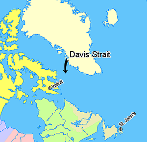
Davis Strait데이비스 해협(프랑스어: Détrot de Davis)은 래브라도 해의 북쪽에 위치한 대서양의 북쪽 팔이다. 중서부 그린란드와 캐나다 누나부트의 배핀 섬 사이에 있다. 북쪽으로는 배핀 만이 있다. 이 해협은 영국 탐험가 존 데이비스 (1550–1605)가 북서항로를 탐색하면서 이 지역을 탐험하면서 이름을 붙였다. 1650년대에 그것은 고래 사냥에 사용되었다.
범위
국제수로기구(International Hydrographic Organization)는 데이비스 해협의 한계를 다음과 같이 정의한다.[1]
북쪽에서. 배핀 만 남방한계[녹지와 배핀랜드의 북위 70° 평행도.
동양에서. 그린란드의 남서쪽 해안.
남쪽에서. 그린란드와 래브라도 사이의 북위 60°의 평행선.
서양에서. 노스웨스턴 통로 남쪽 70°의 동쪽 한계[배핀 섬의 동쪽 해안에서 동쪽 엄포, 남동쪽 극지방까지]와 허드슨 해협[배핀 섬의 남동쪽 극한인 동쪽 엄포로부터의 선]61°53′N 65°57′W / 61.883°N 65.950°W), to Point Meridian, the Western extreme of Lower Savage Islands, along the coast to its Southwestern extreme and thence a line across to the Western extreme of Resolution Island, through its Southwestern shore to Hatton Headland, its Southern point, thence a line to Cape Chidley, Labrador (60°24′N 64°26′W / 60.400°N 64.433°W)].
지질학
데이비스 해협은 약 4,500만년에서 6,200만년 전 Palegeneral 시대에 스트라이크 슬립 단층에 의해 형성된, 매장된 그랩(대야)과 능선의 복잡한 지질학적 특징에 의해 저지되어 있다. 스트라이크-슬립 단층은 래브라도 해의 판구조적 움직임을 배핀 만으로 전달하였다. 그것은 세계에서 가장 넓은 해협이다.
깊이
수심이 1~2천 미터인 이 해협은 남쪽의 래브라도 해보다 훨씬 얕다.
조수
이 해협은 30~60피트(9.1~18.3m)에 이르는 사나운 조수로 유명해 초기 탐험가들을 낙담시켰다.[citation needed]
석유와 가스
미국 지질조사국은 전 세계 미발견 석유 매장량의 최소 13%, 미발견 가스 주머니의 30%가 북극에 위치해 있으며 그린란드 주변 바다에는 잠재적으로 많은 양의 천연가스와 적은 양의 원유와 천연가스 액체가 매장되어 있다고 추정했다.[2][3] 이로 인해 그린란드의 장관과 지방의회는 잠재적인 탄화수소(석유와 가스) 추출에 대해 육지로부터 많은 양보를 제공하게 되었다. 가장 큰 양보 구역은 주로 데이비스 해협과 배핀 만 등 그린란드 서쪽 해역에 위치하지만 동쪽의 그린란드 해역에서도 몇 가지 양보 폭이 작다.[4][5][6][7]
참조
- ^ "Limits of Oceans and Seas, 3rd edition" (PDF). International Hydrographic Organization. 1953. Retrieved 28 December 2020.
- ^ "90 Billion Barrels of Oil and 1,670 Trillion Cubic Feet of Natural Gas Assessed in the Arctic". US Geological Survey (USGS). 23 July 2008. Retrieved 17 April 2016.
- ^ "Assessment of Undiscovered Oil and Gas Resources of the West Greenland" (PDF). US Geological Survey (USGS). May 2008. Retrieved 17 April 2016.
- ^ Lisa Gregoire (15 May 2014). "Greenland pushing ahead with oil and gas development". Nunatsiaq Online. Nunatsiaq News. Retrieved 17 April 2016.
- ^ "Current Licences". Bureau of Mineral and Petroleum (Greenland). Retrieved 17 April 2016.
- ^ "Map of exclusive hydrocarbon licences" (PDF). Bureau of Mineral and Petroleum (Greenland). February 2016. Retrieved 17 April 2016.
- ^ "Approved Hydrocarbon Activities". Bureau of Mineral and Petroleum (Greenland). 31 October 2015. Retrieved 17 April 2016.
추가 읽기
- 보어트만, 데이비드 Davis 해협, West Greenland에서 기름 유출 민감 지역 지도 작성 기름 유출 민감도 지도와 관련된 생물학적 데이터 검토 및 데이터 공백 식별 덴마크 코펜하겐: 그린란드 환경 연구소, 1992.
- Crawford, R. E. Life History of Davis 해협 그린란드 핼리부트(Greenland Halibut)와 Cumberland 사운드 어장 참조 위니펙: 1992년 수산업해양학부.
- Drüe, C.; Heinemann, G. (2001). "Airborne Investigation of Arctic Boundary-Layer Fronts over the Marginal Ice Zone of the Davis Strait". Boundary-Layer Meteorology. 101 (2): 261–292. doi:10.1023/A:1019223513815.
- Heide-Jørgensen, M.P.; Stern, H.; Laidre, K.L. (2007). "Dynamics of the sea ice edge in Davis Strait". Journal of Marine Systems. 67 (1–2): 170–178. doi:10.1016/j.jmarsys.2006.10.011.
- Credland, Arthur (1998). "The Greenland and Davis Strait trade 1740–1880. A.G.E. Jones. 1997. Bluntisham: Bluntisham Books, xxxiii + 230 p, hard cover. ISBN 1-871999-08-1". Polar Record. 34 (189): 162–163. doi:10.1017/S0032247400015400.
- Jørgensen, O. A.; Hvingel, C.; Møller, P. R.; Treble, M. A. (2005). "Identification and mapping of bottom fish assemblages in Davis Strait and southern Baffin Bay". Canadian Journal of Fisheries and Aquatic Sciences. 62 (8): 1833–1852. doi:10.1139/f05-101.
- Mallory, Mark L.; Roberston, Gregory J.; Moenting, Alissa (2006). "Marine plastic debris in northern fulmars from Davis Strait, Nunavut, Canada". Marine Pollution Bulletin. 52 (7): 813–815. doi:10.1016/j.marpolbul.2006.04.005. PMID 16753186.
- 로스, W. 길리스. 데이비스 해협 고래 어장의 북극 고래잡이, 얼음바다 내러티브. 캐나다 토론토: 어윈 퍼브, 1985년 ISBN 0-7725-1524-7
외부 링크
- 2005년 6월 MODIS의 데이비스 해협 위성사진, 녹은 연못이 보인다.


