파르디시야
Fardisya파르디시야 فرديسيا | |
|---|---|
| 어원[1]: 파라다이스 | |
.jpg) 1870년대 지도 1870년대 지도.jpg) 1940년대 지도 1940년대 지도.jpg) 현대 지도 현대 지도.jpg) 1940년대 현대식 오버레이 맵 사용 1940년대 현대식 오버레이 맵 사용파디시야 주변의 역사 지도 시리즈 (버튼 클릭) | |
| 좌표:32°16°41°N 35°00′47§ E/32.27806°N 35.01306°E좌표: 32°16°41°N 35°00°47°E / 32.27806°N 35.01306°E / | |
| 팔레스타인 그리드 | 151/187 |
| 지정학적 실체 | 필수 팔레스타인 |
| 소구 | 툴캄 |
| 인구 감소 연월일 | 1948년 4월 1일 |
| 지역 | |
| • 합계 | 1,092dunams (12.092km 또는 270에이커) |
| 인구. (1945년) | |
| • 합계 | 이십[2][3] |
| 현재 지역 | 샤르 에프레임[4] |

파르디시야는 툴카름에서 남쪽으로 2.5km 떨어진 툴카름 소구에 있던 팔레스타인 아랍 마을이었다.
1948년 4월 1일 팔레스타인 강제 내전에서 해안 청소 작전으로 인구가 감소했고, 버려진 집 한 채를 제외하고는 대부분 파괴되었다.
오늘날 그 마을이 서 있던 지역은 아랍-이스라엘 마을인 타이베에 편입되었다.
역사
고고학 발굴은 철기 시대(기원전 10세기)의 도자기와 로마 [5][6]시대의 석관을 찾아냈다.
십자군은 파디시야를 [4]파데시라고 불렀다.1207-08년 병원 사람들은 카이사레아의 줄리아나 부인으로부터 파라온(파룬)과 센기비스(키르바트 니프 주바일)[7]의 마을을 받았습니다.파르데시는 이 [8]땅의 남쪽 경계를 표시했다.
1265년, 파디시아는 십자군을 축출한 후 그의 에미리트에게 할당된 마을과 재산 중 하나였고, 파디시아의 전부는 그의 에미리트인 사이프 알 딘 바이다간 알 [9]루크니에게 주어졌다.
오스만 시대
파르디사는 1517년 팔레스타인 전역과 함께 오스만 제국에 편입되었고, 1596년 나블루스의 리와 지방의 바니사브의 나히야에 있는 것으로 세무서에 기록되었다.그것은 모두 무슬림인 83명의 인구를 가지고 있었다.마을 사람들은 밀, 보리, 여름 작물, 올리브 나무, 염소 및/또는 벌집을 포함한 다양한 농산물의 33%의 고정 세율을 지불했습니다. 총 5,000 아크체입니다.모든 수익이 [4][10]헛되이 되었다.
1838년 푸르디시아는 나블루스 [11]서쪽 베니 사브 지역에 있는 마을로 주목받았다.1870년, 빅토르 게랭은 마을이 [12]언덕 위에 위치해 있다고 언급했다.1881년, PEF의 서부 팔레스타인 조사(SWP)는 "언덕 가장자리에 있는 작은 마을,[13] 야자나무에서 자라는 것만으로 주목할 만한 마을"이라고 묘사했다.
영국 위임 통치 시대
1922년 팔레스타인 인구 조사에서는 모두 무슬림인 [14]15명의 마을 주민이 있었으며 1931년 인구 조사에서는 총 14채의 [15]주택에서 55명의 무슬림으로 증가했다.
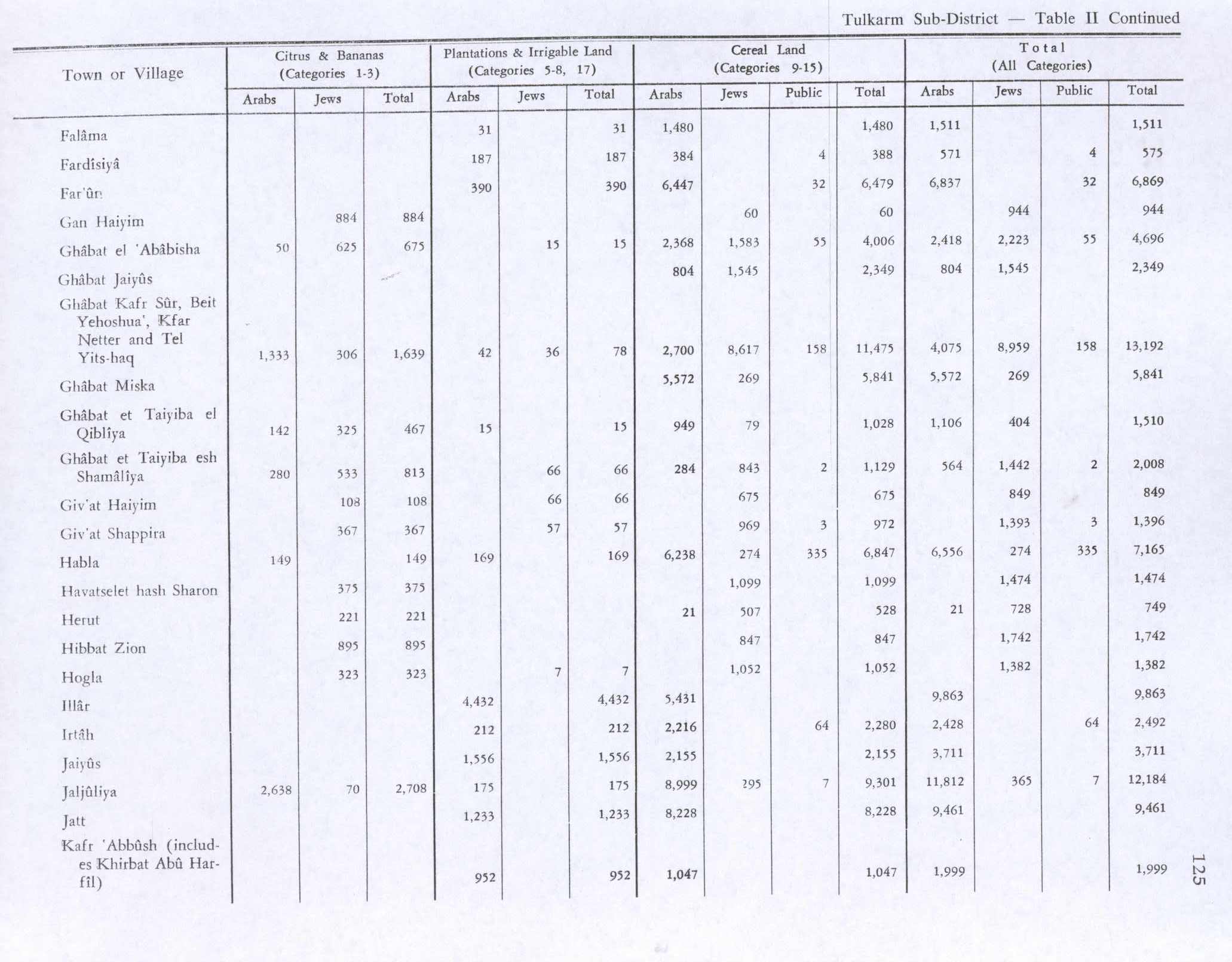
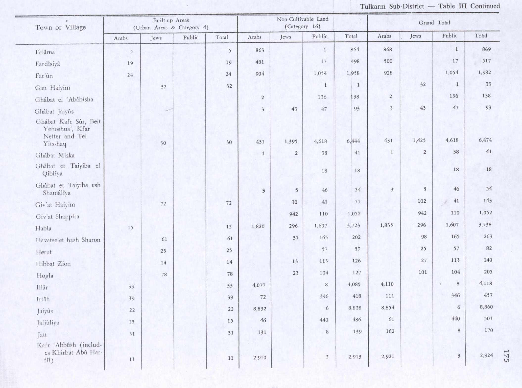
1945년 통계에 따르면 파르디시야는 20명의[2] 무슬림과 총 1,092두둠의 [3]땅을 가지고 있었다.이 중 농원 및 관개지가 187개, [16]곡물이 388개,[17] 축산지가 19개였다.

파르디시야 1942 1:20,000

파르디시아 1945 1:250,000

마캄 에쉬 무사 또는 알 셰이크 마수드


1948년 여파
모샤브 샤르 에프레임은 파디시아의 [4]땅 근처에 있다.
레퍼런스
- ^ 파머, 1881년, 페이지 182
- ^ a b 1945년 통계부, 페이지 20
- ^ a b c 팔레스타인 정부 통계국Village Statistics, 1945년 4월하다위에서 인용, 1970, 74페이지
- ^ a b c d 칼리디, 1992년, 페이지 552
- ^ Massarwa, 2009, Khirbat Fardisya
- ^ a b 마사르와, 2008, 키르바트 파르디시야
- ^ Cart. des Hosp, No. 1251; 및 Röhricht, 1893, RHH 페이지 220, No. 819
- ^ 프링글, 1986, 30페이지
- ^ Ibn al-Furat, 1971, 페이지 82, 209, 249 (지도)
- ^ 휘테로스와 압둘파타, 1977, 페이지 141
- ^ 로빈슨과 스미스, 1841년, 제3권, 부록 2, 페이지 128
- ^ 게랭, 1875년, 352페이지
- ^ Conder and Kitchner, 1882, SWP II, 페이지 164
- ^ Barron, 1923년, Toolkarem 하위 구역, 표 IX, 27페이지
- ^ 밀스, 1932, 54페이지
- ^ 팔레스타인 정부 통계국Village Statistics, 1945년 4월하다위에서 인용, 1970, 125페이지
- ^ 팔레스타인 정부 통계국Village Statistics, 1945년 4월하다위에서 인용, 1970, 페이지 175
참고 문헌
- Barron, J. B., ed. (1923). Palestine: Report and General Abstracts of the Census of 1922. Government of Palestine.
- Conder, C.R.; Kitchener, H.H. (1882). The Survey of Western Palestine: Memoirs of the Topography, Orography, Hydrography, and Archaeology. Vol. 2. London: Committee of the Palestine Exploration Fund.
- Department of Statistics (1945). Village Statistics, April, 1945. Government of Palestine.
- Guérin, V. (1875). Description Géographique Historique et Archéologique de la Palestine (in French). Vol. 2: Samarie, pt. 2. Paris: L'Imprimerie Nationale.
- Hadawi, S. (1970). Village Statistics of 1945: A Classification of Land and Area ownership in Palestine. Palestine Liberation Organization Research Center.
- Hütteroth, Wolf-Dieter; Abdulfattah, Kamal (1977). Historical Geography of Palestine, Transjordan and Southern Syria in the Late 16th Century. Erlanger Geographische Arbeiten, Sonderband 5. Erlangen, Germany: Vorstand der Fränkischen Geographischen Gesellschaft. ISBN 3-920405-41-2.
- Ibn al-Furat (1971). J. Riley-Smith (ed.). Ayyubids, Mamluks and Crusaders: Selections from the "Tarikh Al-duwal Wal-muluk" of Ibn Al-Furat : the Text, the Translation. Vol. 2. Translation by Malcolm Cameron Lyons, Ursula Lyons. Cambridge: W. Heffer.
- Khalidi, W. (1992). All That Remains: The Palestinian Villages Occupied and Depopulated by Israel in 1948. Washington D.C.: Institute for Palestine Studies. ISBN 0-88728-224-5.
- Masarwa, Durar (2008-01-08). "Khirbat Fardisya Final Report" (120). Hadashot Arkheologiyot – Excavations and Surveys in Israel.
{{cite journal}}:Cite 저널 요구 사항journal=(도움말) - Massarwa, Abdallah (2009-06-07), Khirbat Fardisya Final Report, Hadashot Arkheologiyot – Excavations and Surveys in Israel
- Mills, E., ed. (1932). Census of Palestine 1931. Population of Villages, Towns and Administrative Areas. Jerusalem: Government of Palestine.
- Morris, B. (2004). The Birth of the Palestinian Refugee Problem Revisited. Cambridge University Press. ISBN 978-0-521-00967-6.
- Palmer, E.H. (1881). The Survey of Western Palestine: Arabic and English Name Lists Collected During the Survey by Lieutenants Conder and Kitchener, R. E. Transliterated and Explained by E.H. Palmer. Committee of the Palestine Exploration Fund.
- Pringle, D. (1986). The Red Tower (al-Burj Al-Ahmar): Settlement in the Plain of Sharon at the Time of the Crusaders and Mamluks A.D.1099-1516. University of Michigan. ISBN 0950054267.
- Robinson, E.; Smith, E. (1841). Biblical Researches in Palestine, Mount Sinai and Arabia Petraea: A Journal of Travels in the year 1838. Vol. 3. Boston: Crocker & Brewster.
- Röhricht, R. (1893). (RRH) Regesta regni Hierosolymitani (MXCVII-MCCXCI) (in Latin). Berlin: Libraria Academica Wageriana.
외부 링크
- 파디시아에 오신 것을 환영합니다
- 파르디시야
- 서팔레스타인 조사, 지도 11: IAA, Wikimedia


