로번데일
Roeburndale| 로번데일 | |
|---|---|
 로번데일 감리교 예배당 | |
| 인구. | 76(2001) |
| OS 그리드 참조 | SD6063 |
| 민교구 |
|
| 구 | |
| 쉬레 현 | |
| 지역 | |
| 나라 | 잉글랜드 |
| 주권국 | 영국 |
| 포스트타운 | 랜캐스터 |
| 우편번호 지구 | LA2 |
| 다이얼 코드 | 015242 |
| 경찰 | 랭커셔 |
| 불 | 랭커셔 |
| 구급차 | 노스웨스트 |
| 영국 의회 | |
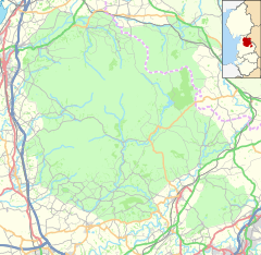
Roeburndale은 랭커스터시와 영국 랭커셔 카운티에 있는 시민 교구이다.2001년에는 인구가 [1]76명이었다.2011년 인구조사에서 로번데일은 클로튼과 함께 분류되었다.그 교구는 살터 마을을 포함한다.Roeburn 강은 교구를 통해 흐른다.
역사
2022년 1월, [2][3]로번데일의 로번 강에 다리가 붕괴되어 1명이 사망하고 다른 사람이 부상했다.
「 」를 참조해 주세요.
레퍼런스
- ^ "Parish headcount" (PDF). Archived from the original (PDF) on 10 December 2006. Retrieved 13 April 2008.
- ^ "Man dead, several injured following bridge collapse". belfasttelegraph. ISSN 0307-1235. Retrieved 19 January 2022.
- ^ "Four rescued from Roeburndale river after bridge crash". BBC News. 18 January 2022. Retrieved 19 January 2022.


