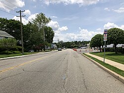
뉴저지 주 본햄타운
Bonhamtown, New Jersey뉴저지 주 본햄타운 | |
|---|---|
 모리스 대로 메인 스트리트 | |
| 좌표: 40°31′24″N 74°21′28″w / 40.52333°N 74.35778°W좌표: 40°31′24″N 74°21′28″W / 40.52333°N 74.35778°W/ | |
| 나라 | |
| 주 | |
| 카운티 | 미들섹스 |
| 타운쉽 | 에디슨 |
| 표고 | 72피트(22m) |
| 우편번호 | 08837 |
| GNIS 피쳐 ID | 874849[1] |
본햄타운(Bonhamtown)[2][3][4][5][6][7]은 미국 뉴저지 주 미들섹스 카운티에 있는 에디슨 타운쉽의 한 구역이다.
이 지역은 17세기 자유보유자인 니콜라스 본햄의 이름을 따서 명명되었다. 뉴 도버, 뉴 더럼, 스텔튼과 함께 시군이 라리탄 타운쉽으로 알려졌을 때 설립된 오래된 역사 공동체 중 하나이다.[8]
본햄타운은 다음과 같은 몇 가지 주요 도로로 둘러싸여 있다. 주간고속도로 287번, 뉴저지 턴파이크, 미국 국도 1호선, 27번 국도, 440번 국도.
콘레일 공유자산운용(CRCX) 본햄타운지점은 북동 회랑에서 옛 라리탄 아스널의 터전인 라리탄 센터까지 이 지역을[9] 관통한다.[10]
참고 항목
참조
- ^ a b "Bonhamtown". Geographic Names Information System. United States Geological Survey.
- ^ 뉴저지 주, 지역성 검색. 2015년 2월 7일에 접속.
- ^ "Township History". www.edisonnj.org.
- ^ "NJDOT Graphic Information System Maps Middlesex" (PDF). New Jersey Department of Transportation. Retrieved March 2, 2020.
- ^ Spies, Stacy (2001), Edison, Arcadia Publishing, ISBN 9780738505497
- ^ Gordon, Thomas Francis (1834). "A Gazetteer of the State of New Jersey: Comprehending a General View of Its Physical and Moral Condition, Together with a Topographical and Statistical Account of Its Counties, Towns, Villages, Canals, Rail Roads, &c., Accompanied by a Map".
- ^ Fleming, Herbert R. (1947). "Map of Middlesex County, New Jersey". Middlesex County (NJ). Retrieved September 8, 2021.
- ^ Gannett, Henry (January 28, 1895). "A Geographic Dictionary of New Jersey". U.S. Government Printing Office – via Google Books.
- ^ Heiss, Ralph A. (May 10, 2009). The Lehigh Valley Railroad Across New Jersey. Arcadia Publishing. ISBN 9780738565767 – via Google Books.
- ^ "5. Interior, looking east, from doorway to bay 6 - Raritan Arsenal, Warehouse N-5, 2890 Woodbridge Avenue, Bonhamtown, Middlesex County, NJ". Library of Congress, Washington, D.C. 20540 USA.
외부 링크
| 위키미디어 커먼즈에는 뉴저지 본햄타운과 관련된 미디어가 있다. |


