뉴저지 주
Arneytown, New Jersey뉴저지 주 | |
|---|---|
 | |
 아르니타운  아르니타운  아르니타운  아르니타운 | |
| 좌표:40°06′05§ N 74°33′58″w/40.10139°N 74.56611°W좌표: 40°06°05°N 74°33µ58ºW / 40.10139°N 74.56611°W / [1] | |
| 나라 | |
| 주 | |
| 군 | 벌링턴 몬머스 |
| 타운십 | 북하노버 및 어퍼프리홀드 |
| 승진 | 164 피트 (50 m) |
| 시간대 | UTC-5(동부(EST)) |
| • 여름 (DST) | UTC-4(동부(EDT)) |
| 지역 번호 | 609, 640 |
| GNIS 기능 ID | 874381[1] |
Arneytown은 벌링턴 카운티의 노스하노버 타운십과 [1][2][3]뉴저지 몬머스 카운티의 어퍼 프리홀드 타운십 경계에 있는 주 라인 로드(City Line Road)를 따라 위치한 비법인 커뮤니티입니다.Jacobstown에서 북쪽으로 2마일(3.2km) 떨어져 있습니다.지방 도로(Country Line Road)는 동부 저지 주와 서부 저지 주의 경계선에 있었다.이 지역은 18세기 퀘이커 정착민들에 의해 한때 Upper Freehold라고 불렸다.1827년 최초의 우체국이 설립되면서 아르니타운으로 [4]알려지게 되었다.
역사
로리 하우스라고도 알려진 아르니타운 선술집은 1731년에 지어졌다.1762년 윌리엄 로리가 리처드 [4]플랫에게 물려주었을 때 술집으로 기록되었다.
역사 지구
아르니타운 역사 지구 | |
 로리 하우스 | |
| 위치 | 지방 도로(엘리스데일-아르니타운 도로) 및 체스터필드-아르니타운 도로 |
|---|---|
| 지역 | 58에이커(23ha) |
| 지었다. | 1731 |
| 건축 양식 | 그리스 부흥, 그루지야어 |
| NRHP 참조 | 67451850[5] |
| NJRHP No. | 854[6][7] |
| 중요한 날짜 | |
| NRHP에 추가됨 | 1977년 12월 12일 |
| 지정 NJRHP | 1974년 12월 26일 |
Arneytown Historic District는 58에이커(23ha)의 역사 지구로 커뮤니티를 둘러싸고 있습니다.1977년 12월 12일 건축과 지역 사회 발전의 중요성을 인정받아 국립사적등록소에 등록되었다.이 지역에는 Historic American Buildings Survey에 의해 개별적으로 기록된 3개의 건물, 즉 Lawrie House, Duncan Mackenzie Place, Emley-Wilde [4]House를 포함하여 12개의 건물이 있습니다.
묘지
윌리엄 C 준장입니다도일 참전용사 기념 묘지는 225에이커(91ha)의 토지에 있는 공동체 남쪽에 있습니다.1986년 5월 30일 주지사 토마스 킨에 의해 헌정되었고 1989년 [8]1월 3일 도일의 이름을 따왔다.
갤러리
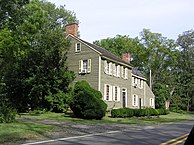
18세기 후반의 집
.JPG)
「 」를 참조해 주세요.
레퍼런스
- ^ a b c d "Arneytown". Geographic Names Information System. United States Geological Survey.
- ^ "Locality Search". State of New Jersey.
- ^ Gannett, Henry (1894). Bulletin 118: A Geographic Dictionary of New Jersey (PDF). U.S. Government Printing Office. p. 13. doi:10.3133/b118.
- ^ a b c Israel, Nancy (August 1974). "National Register of Historic Places Inventory/Nomination: Arneytown Historic District". National Park Service. 10장의 사진 첨부
- ^ "National Register Information System – (#67451850)". National Register of Historic Places. National Park Service. November 2, 2013.
- ^ "New Jersey and National Registers of Historic Places - Burlington County" (PDF). New Jersey Department of Environmental Protection - Historic Preservation Office. March 23, 2021. p. 14.
- ^ "New Jersey and National Registers of Historic Places - Monmouth County" (PDF). New Jersey Department of Environmental Protection - Historic Preservation Office. March 23, 2021. p. 18.
- ^ "BG William C. Doyle Veterans Memorial Cemetery". New Jersey Department of Military and Veterans Affairs.
외부 링크
 Wikimedia Commons 뉴저지주 Arneytown 관련 미디어
- Historic American Buildings Survey(HAB) No. NJ-134, "Lawrie House, Arneytown, Monmouth County, NJ", 6장의 사진, 25장의 측정 도면, 4장의 데이터 페이지
- HABS No. NJ-202, "Duncan Mackenzie Place, City Line Road, Monmouth County, Arneytown, NJ", 사진 5장, 측정 도면 24장, 데이터 페이지 7장
- HABS No. NJ-303, "미국 뉴저지 몬머스 카운티 Arneytown, Emley-Wilde House", 사진 5장, 측정 도면 33장, 데이터 페이지 3장
미국 뉴저지 주 벌링턴 카운티의 자치체 및 커뮤니티 | ||
|---|---|---|
| 도시들 |  | |
| 자치구 | ||
| 타운십 | ||
| CDP | ||
| 다른. 법인화되어 있지 않다 커뮤니티 |
| |
| 유령 도시 | ||

| 일반 | |
|---|---|
| 국립도서관 | |


