뉴저지 주 몬머스 카운티 콕스 코너
Coxs Corner, Monmouth County, New Jersey뉴저지 주 콕스 코너 | |
|---|---|
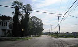
 동쪽을 향한 교차로 보기 | |
| 좌표: 40°10′54″n 74°30′41″w / 40.18167°N 74.51139°W좌표: 40°10′54″N 74°30′41″W / 40.18167°N 74.51139°W/ | |
| 나라 | |
| 주 | |
| 카운티 | 몬머스 |
| 타운쉽 | 어퍼 프리홀드 |
| 에 대해 명명됨 | 제임스 콕스 |
| 표고 | 154피트(47m) |
| 시간대 | UTC-5(동부(EST)) |
| • 여름(DST) | UTC-4(EDT) |
| GNIS 피쳐 ID | 881965[1] |
콕스 코너(Cox's Corner 또는 Wrightsville)는 미국 뉴저지 주 몬머스 카운티의 어퍼 프리홀드 타운쉽 내에 위치한 비법인 커뮤니티다.[3][4] 이곳 '박스 그로브'의 가정집에서 살던 제임스 콕스(1753–1810) 하원의원 겸 준장의 이름을 딴 이곳은 카운티 524번 국도와 43번 국도의 경계에 있다.[2][5][6] 상층 자유보유 역사적 농지 바이웨이가 이 지역을 통과한다.[5][7]
역사
콕스 가족은 1600년대부터 뉴저지 주 어퍼 프리홀드에 살았다.[2] 어퍼 프리홀드 지역에서는 1731년까지 핵심 교차로에 농장이 만들어졌는데, 그 중 하나가 나중에 콕스 코너의 바로 동쪽에 있는 라이트스빌로 명명되었다.[8]
콕스의 코너 로드 분기점은 식민지 시대에 존재했고, 한 집인 메리노 힐은 사무엘 G를 위해 지어졌다. 라이트빌에서 태어난 라이트(1781년–1845년). 콕스와 마찬가지로 그도 의회에 선출되었으나 취임하기 전에 죽었다.[9][10] 메리노 힐은 국가 사적지에 등재되어 있다. 환경보호부와 몬머스 카운티 역사협회는 콕스 코너에 있는 이웃집 6채와 함께 이 집이 역사적인 마을 지위에 적합하다고 선언했다.[9] 1920년에 "토마스와 엘리자베스 블래쉬포드 콕스가 이스트저지주의 첫 정착민 중 하나"[9]라는 기록을 남기고 콕스 가문을 기념하기 위한 기념비가 세워졌다.
콕스 코너가 뉴저지 지도에 처음 등장한 것은 1917년이다.[2] 1987년 당시 메리노 힐의 소유주였던 그는 라이트스빌이 동쪽으로 조금 떨어진 곳에 정착지의 이름이었다고 썼다. 그러나 그 명칭은 사용되지 않게 되었고, 그 실체는 더 이상 존재하지 않게 되었다. 그러나 그 명칭은 현대 지도에서 부활되어 코너의 이름을 잘못 지었다.[11]
참조
- ^ a b "Wrightsville". Geographic Names Information System. United States Geological Survey.
- ^ a b c d Randall Gabrielan (2001). Allentown and Upper Freehold Township. Arcadia Publishing. p. 103. ISBN 9780738500942.
- ^ "An Alphabetical Listing of Local Places and Incorporated Municipalities in the State of New Jersey". 1962. Retrieved 2015-03-16.
- ^ 뉴저지 주, 지역성 검색. 2015년 3월 8일에 접속.
- ^ a b Meritt, Jane (29 March 2006). "Byway would lead tourists through area's unique past". The Examiner. Archived from the original on 17 March 2015. Retrieved 17 March 2015.
- ^ Meirs, David A. "Upper Freehold Historic Farmland Byway: Tour Narrative". Docstoc. Intuit. Retrieved 17 March 2015.
United States Congress. "Cox, James, (1753–1810) (id: C000834)". Biographical Directory of the United States Congress.
Cocks, George William (1912). The Cox Family in America. New York: George William Cocks. pp. 165, 167. Retrieved 17 March 2015. - ^ "Scenic Byways in New Jersey Upper Freehold Historic Farmland Byway". State of New Jersey Department of Transportation. Retrieved 17 March 2015.
- ^ Upper Freehold Historic Farmland Byway Corridor Management Plan (PDF). Upper Freehold Open Space/Farmland Preservation Committee. 2010. Retrieved 17 March 2015.
"Wright family papers". Archival Collections. Hagley Museum and Library. Retrieved 17 March 2015. - ^ a b c Megitt, Jane (4 December 2013). "Residents acknowledge history of Cox's Corner". Examiner. Archived from the original on 17 March 2015. Retrieved 17 March 2015.
- ^ United States Congress. "Wright, Samuel Gardiner, (1781–1845) (id: W000769)". Biographical Directory of the United States Congress.
- ^ Wright, Richard R.; Wright Meirs, Elizabeth G. (29 December 1987). "Merino Hill House and Farm". National Register of Historic Places Nomination Form. National Park Service. Retrieved 17 March 2015.
| 위키미디어 커먼즈에는 뉴저지 주 몬머스 카운티 콕스 코너와 관련된 미디어가 있다. |


