유라시아판
Eurasian Plate| 유라시아판 | |
|---|---|
 유라시아판 | |
| 유형 | 주요한 |
| 대략적인 면적 | 67,800,000 km2 (26,200,000 sq mi)[1] |
| 무브먼트1 | 남쪽 |
| 스피드1 | 7–14 mm (0.28–0.55 in)/year |
| 특징들 | 유럽(아이슬란드 일부 포함), 아시아, 대서양, 북극해 |
| 아프리카 판 대비 1상대적 | |
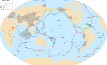
유라시아판은 인도 아대륙, 아라비아 아대륙, 시베리아 동부 체르스키 산맥 동쪽 지역을 제외하고 유라시아 대륙 대부분(유럽과 아시아의 전통적인 대륙으로 구성된 육지)을 포함하는 지각판입니다. 또한 서쪽으로 대서양 중부 능선까지, 북쪽으로 각켈 능선까지 뻗어 있는 해양 지각을 포함합니다.
경계
서쪽 가장자리는 북아메리카판과 누비아판과의 삼중 접합판 경계로, 지진 활동이 활발한 아조레스 삼중 접합부가 아이슬란드를 향해 대서양 중앙 능선을 따라 북쪽으로 뻗어 있습니다.[2][3] 대서양 중앙 능선과 같은 능선은 분기판 경계에서 형성됩니다. 그들은 깊은 바닷속에 위치해 있고 연구하기가 매우 어렵습니다. 과학자들은 태양계의 행성들보다 바다 능선에 대해 덜 알고 있습니다.[4]
유라시아판과 아나톨리아 서브판, 아라비아판이 만나는 또 다른 삼중접합점이 있습니다. 현재 동아나톨리아 단층대에서 유라시아판과 아라비아판의 충돌로 아나톨리아 서브판이 압착되고 있습니다.[5][6]
일본 주변 지역의 북미판과 유라시아판의 경계는 "시프트"(shifty)라고 설명되어 왔습니다.[7] 최근 구조학, 지진 및 지진 초점 메커니즘을 기반으로 다양한 지도가 있습니다. 가장 단순한 판 형상은 난센 능선에서 북아시아의 넓은 변형지대를 거쳐 오호츠크 해까지 경계를 그리고 남쪽으로 사할린섬과 홋카이도를 거쳐 일본 해구의 삼중 교차점까지 그 경계를 그립니다.[8] 그러나 이러한 단순한 견해는 보다 최근의 연구에 의해 성공적으로 도전을 받았습니다. 1970년대에 일본은 북아메리카판의 동쪽 경계가 홋카이도 남부를 통과할 때 북아메리카판과 4중접점에 있는 유라시아판에 위치한 것으로 여겨졌습니다. 1990년대의 새로운 연구는 오호츠크 미세판이 북아메리카판과 아무리아 미세판과의 경계로부터 독립적이며 때로는 서부 경계가 알려지지 않은 "유라시아판 내의 분열"[additional citation(s) needed]로 묘사된다는 것을 뒷받침했습니다.[9][10]
1973년 엘드펠 폭발, 1783년 라키 폭발, 2010년 에이야프얄라ö쿨 폭발 등 아이슬란드의 모든 화산 폭발은 북아메리카판과 유라시아판이 서로 떨어져 나가면서 발생하는데, 이는 판 경계력이 서로 다르기 때문입니다.
유라시아판과 인도판의 수렴 경계가 히말라야 산맥을 형성했습니다. 중앙아시아의 지구역학은 유라시아판과 인도판의 상호작용에 의해 지배되고 있습니다. 이 지역에서는 중앙아시아와 동아시아 통과 지역을 형성하는 많은 아판 또는 지각 블록이 인식되었습니다.[11]

참고 항목
참고문헌
- ^ "Sizes of Tectonic or Lithospheric Plates". Geology.about.com. 2014-03-05. Retrieved 2015-12-26.
- ^ F.O. Marques, J.C. Catalão, C.DeMets, A.C.G. Costa, A. Hildenbrand (2013). "GPS and tectonic evidence for a diffuse plate boundary at the Azores Triple Junction" (PDF). Earth and Planetary Science Letters. 381: 177–187. Bibcode:2013E&PSL.381..177M. doi:10.1016/j.epsl.2013.08.051.
{{cite journal}}: CS1 maint: 다중 이름: 작성자 목록(링크) - ^ Machado, Adriane; Azevedo, José M. M.; Alemeida, Delia P.M.; Farid Chemale Jr. (2008). "Geochemistry of Volcanic Rocks from Faial Island (Azores)" (PDF). Lisbon: e-Terra, GEOTIC – Sociedade Geológica de Portugal. pp. 1–14. Archived from the original (PDF) on 11 May 2011. Retrieved 17 April 2010.
- ^ "Plate Boundaries". education.nationalgeographic.org.
- ^ "Eastern Turkey IRIS Report". atlas.geo.cornell.edu.
- ^ "The Bekten Fault: the palaeoseismic behaviour and kinematic characteristics of an intervening segment of the North Anatolian Fault Zone, Southern Marmara Region, Turkey". Geodinamica Acta. 28 (4). 2016. doi:10.1080/09853111.2016.1208524.
The Anatolian tectonic block (sub-plate) is being affected by converging plate movements that occur between the Arabian-African and Eurasian plates (e.g. Armijo, Meyer, Hubert, & Barka, Citation1999; Bozkurt, Citation2001; Jackson & McKenzie, Citation1984; Le Pichon, Chamot-Rooke, Lallemant, Noomen, & Veis, Citation1995; McKenzie, Citation1972, 1978; Şengör, Citation1979, 1980; Sengör, Görür, & Saroglu, Citation1985; Taymaz, Jackson, & McKenzie, Citation1991). As a result of this collision, the North Anatolian (NAF) and East Anatolian (EAF) transform faults have been formed. The Anatolian sub-plate is bounded to the north and east by these faults. The impingement started to move the sub-plate westward and resulted compression and uplifts near the Karlıova triple junction in the Eastern Anatolia. As a result of anti-clockwise rotational movement of the Anatolian sub-plate in a westward direction four different neotectonic regions have been formed namely: (1) East Anatolian compressional region, (2) North Anatolian region, (3) Central Anatolian 'ova' region and (4) West Anatolian extensional region (Sengör et al., Citation1985).
- ^ Van Horne, A.; Sato, H.; Ishiyama, T.; Kato, N. (December 2015). "The Problem With the Plate Boundary in the Sea of Japan". AGU Fall Meeting Abstracts T31B-2879.
Hence, the problem: geodetic models imply a plate boundary between Japan and Eurasia, but published geological and seismological evidence does not support placing it in the Japan Sea or at the ISTL. If, as studies show, almost half of the convergence between North America and Eurasia is taken up in Hokkaido and across N Japan, the small amount of remaining convergence may be difficult to distinguish given the large elastic response in the upper plate (N Honshu) after the 2011 Tohoku-oki (M9.0) earthquake, and strong coupling at the megathrust. To draw such a plate boundary on tectonic maps implies a degree of certainty about its location which is unfounded
- ^ Chapman, Michael E.; Solomon, Sean C. (February 10, 1976). "North American-Eurasian Plate Boundary in Northeast Asia" (PDF). Journal of Geophysical Research. 81 (5). Retrieved 9 February 2024.
- ^ Barnes, Gina L. (2022). Tectonic Archaeology: Subduction Zone Geology in Japan and Its Archaeological Implications. Archaeopress Publishing Limited. pp. 35–6.
- ^ Volcanic and Tectonic Hazard Assessment for Nuclear Facilities. Cambridge University Press. p. 164.
- ^ Y의 "중앙아시아의 최신 지동학과 지진학" Gatinsky, D. Rundquist, G. Vladova, T. Prokhodova


