피닉스 판
Phoenix Plate| 피닉스 판 | |
|---|---|
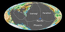
 2억5000만년 전 판탈라사 대양에는 남쪽의 피닉스 판, 북동쪽의 파랄론 판, 북서쪽의 이자나기 판이 보였다. | |
| 유형 | 역사적 |
피닉스 판(Aluk Plate 또는 드레이크 판이라고도 한다)은 고생대 초기부터 신생대 후기까지 존재했던 지각 판이었다. 빠르면 4억1000만년 전 판탈라사 해역에서 이자나기 판과 파랄론 판과 3중 접점을 형성했고, 그 기간 동안 피닉스 판은 곤드와나 동부의 하류로 서브덕팅되고 있었다.[1]
1억5천만~1억3천만년 전 후기 쥬라기-얼리 백악기에 의해 태평양 판은 이자나기-파랄론-피에닉스 3중 접점으로부터 생겨났고, 그 결과 이자나기-파랄론-피에닉스-피에닉스 3중 접점이 만들어졌다.[2] 섭입은 약 1억 2천만년 전에 호주 동부에서 중단되었고, 그 기간 동안 변환/변환 경계선이 형성되었다.[3] 피닉스 판과의 이러한 변형/변환 경계는 남극반도 하의 백악기 후기 전도의 결과로 판이 남쪽으로 계속 내려오면서 약 8천만년 전까지 지속되었다.[3][4]
백악기 후기 또는 신생대 초기에는 피닉스 판의 남서부가 샤르코 판으로 조각되었는데, 이는 파랄론 판의 파편화에 의해 리베라와 코코스 판이 형성되는 것과 거의 같은 방식으로 이루어졌다.[5]
남극판과 피닉스판 사이의 중간 해양 능선인 남극-피닉스 산맥은 피닉스판이 서남태평양 벨링스하우젠판과 태평양판과 경계를 달리하던 백악기 후기부터 신생대 초반까지 시작되었다.[6] 남극-피닉스 능선의 확산률과 남극판과의 피닉스 판의 수렴율의 큰 감소는 약 5천2백3십만년 전에 일어났고, 그 후 5천만년에서 4천3백만년 사이에 남극-피닉스 능선의 한 구간이 전도되었다.[7][8]
비록 1억년 이상 동안 활동적인 전도가 발생했지만 남극-포닉스 능선에 퍼진 해저면이 멈추면서 약 330만년 전 극적으로 멈추거나 느려져 옛 피닉스 판의 잔해가 남극 판에 편입되었다.[6] 이 잔해는 남서 드레이크 통로의 밑부분이며 북동쪽의 섀클턴 파괴 구역, 남서쪽의 영웅 파괴 구역, 남동쪽의 사우스 셰틀랜드 수조, 북서쪽의 멸종된 남극-페닉스 능선에 둘러싸여 있다.[6][9]
참조
- ^ Matthews, Kara J.; Maloney, Kayla T.; Zahirovic, Sabin; Williams, Simon E.; Seton, Maria; Müller, R. Dietmar. "Global plate boundary evolution and kinematics since the late Paleozoic". University of Oxford. p. 752. Retrieved 2020-04-07.
- ^ Smith, Alan D. (2007). "A plate model for Jurassic to Recent intraplate volcanism in the Pacific Oceanic basin". Plates, Plumes, and Planetary Processes. Boulder, Colorado: Geological Society of America. pp. 274, 275, 276. ISBN 978-0-8137-2430-0.
- ^ Jump up to: a b Seton, M.; Müller, R. D. (2008). Reconstructing the junction between Panthalassa and Tethys since the Early Cretaceous. Eastern Australasian Basins III. Sydney: Petroleum Exploration Society of Australia, Special Publications. pp. 263, 264, 265.
- ^ Larter, R. D., A. P. Cunningham, P. F. Barker, K. Gohl, and F. O. Nitsche (2002-12-13). "Tectonic evolution of the Pacific margin of Antarctica, 1, Late Cretaceous tectonic reconstructions" (PDF). Journal of Geophysical Research: Solid Earth. 107 (B12): 2345. Bibcode:2002JGRB..107.2345L. doi:10.1029/2000JB000052.CS1 maint: 작성자 매개변수 사용(링크)
- ^ Larter, Robert D.; Barker, Peter F.; Cunningham, Alex P.; Gohl, Karsten (2002). "Tectonic evolution of the Pacific margin of Antarctica, I. Late Cretaceous tectonic reconstructions" (PDF). Journal of Geophysical Research: Solid Earth. 107: EPM 5-1-EPM 5-19. Bibcode:2002JGRB..107.2345L. doi:10.1029/2000JB000052.
- ^ Jump up to: a b c Eagles, Graeme (2003). "Tectonic evolution of the Antarctic–Phoenix plate system since 15 Ma". Earth and Planetary Science Letters: 97, 98. ISSN 0012-821X.
- ^ McCarron, J. J.; Larter, R. D. (1998). "Late Cretaceous to early Tertiary subduction history of the Antarctic Peninsula". Journal of the Geological Society. 155 (2): 255. doi:10.1144/gsjgs.155.2.0255. S2CID 129764564.
- ^ Taylor, Brian (1995). Backarc Basins: Tectonics and Magmatism. Plenum Press. p. 317. ISBN 0-306-44937-4.
- ^ Riley, Teal R.; Bristow, Charlie S.; Leat, P.T.; Burton-Johnson, Alex (2019). "Geochronology and geochemistry of the northern Scotia Sea: A revised interpretation of the North and West Scotia ridge junction". Earth and Planetary Science Letters. 518: 137. doi:10.1016/j.epsl.2019.04.031. ISSN 0012-821X.


