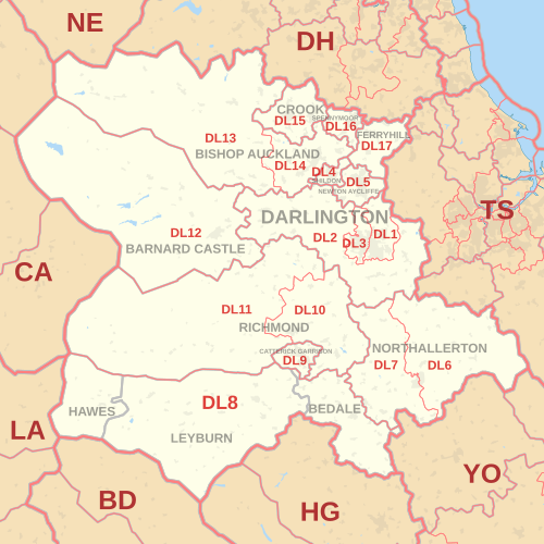
DL 우편번호 영역
DL postcode area우편 번호 구역 경계:
달링턴 | |
|---|---|
| 좌표: 54°31′59″N 1°40′08″w / 54.533°N 1.669°W | |
| 나라 | 영국 |
| 우편 번호 영역 | DL |
| 우편번호영역명 | 달링턴 |
| 포스트 타운즈 | 14 |
| 우편 번호 구역 | 17 |
| 우편 번호 섹터 | 67 |
| 포스트코드(라이브) | 13,282 |
| 포스트코드(전체) | 16,683 |
| 2020년[1] 5월 통계 | |
달링턴 우편번호 지역이라고도 불리는 DL 우편번호 지역은 잉글랜드의 17개 우편번호 구역으로 14개 우편타운으로 세분되어 있다.[2] These districts cover central County Durham (including Darlington, Bishop Auckland, Ferryhill, Crook, Spennymoor, Shildon, Barnard Castle and Newton Aycliffe), northern North Yorkshire (including Northallerton, Bedale, Hawes, Leyburn, Richmond and Catterick Garrison) and a very small part of Cumbria.
커버리지
우편 번호 구역의 대략적인 적용 범위:
| 우편 번호 구 | 포스트타운 | 커버리지 | 지방 기관 영역 |
|---|---|---|---|
| DL1 | 달링턴 | 달링턴 (동쪽) | 달링턴 |
| DL2 | 달링턴 | 스테인드롭, 게인포드, 달링턴의 새 부동산 | 더럼 카운티, 달링턴 |
| DL3 | 달링턴 | 달링턴(서부), 파버데일, 코담 먼데빌 | 달링턴 |
| DL4 | 쉴던 | 실돈 | 더럼 주 |
| DL5 | 뉴턴 아이클리프 | 뉴턴 아이클리프, 하이잉턴 | 더럼 주 |
| DL6 | 노스앨러턴 | Northalerton(동쪽), Ingleby Cross | 햄블턴 |
| DL7 | 노스앨러턴 | 노잘러턴(서쪽), 로만비, 리밍바 | 햄블턴 |
| DL8 | 베데일 | 베데일 | 햄블턴 |
| HAWAES | 호우스 | 리치몬드셔 | |
| 레이번 | 커버햄, 레이번, 미들햄 | 리치몬드셔 | |
| DL9 | 캐터릭 개리슨 | 캐터릭 게리슨 | 리치몬드셔 |
| DL10 | 리치먼드 | 리치먼드, 캐터릭, 브롬튼-우폰-스웨일, 스카치 코너 | 리치몬드셔 |
| DL11 | 리치먼드 | 스왈데일, 리스, 로우 로, 아켄가스데일 | 리치몬드셔, 에덴 |
| DL12 | 바나드 성 | 바너드 성, 보우즈, 미들턴인테스데일 | 더럼 주 |
| DL13 | 오클랜드 주교 | 스탠호프, 프로스터리, 월싱엄, 견인법 | 에덴 더럼 주 |
| DL14 | 오클랜드 주교 | 이븐우드 주교 오클랜드 | 더럼 주 |
| DL15 | 크룩 | 크룩, 윌링턴 | 더럼 주 |
| DL16 | 스피니무어 | 스펜니무어 | 더럼 주 |
| DL16 | 페리힐 | 무통행의[3][4] | |
| DL17 | 페리힐 | 페리힐, 칠튼, 콘포스, 미들햄 주교 | 더럼 주 |
| DL98 | 달링턴 | 무통행의[5] |
지도
참고 항목
참조
- ^ "ONS Postcode Directory Version Notes" (ZIP). National Statistics Postcode Products. Office for National Statistics. May 2020. Table 2. Retrieved 19 June 2020. 단위 우편 번호 지점의 평균으로부터의 좌표,
- ^ Royal Mail, 주소 관리 가이드, (2004)
- ^ "Non Geographic Codes" (PDF). Royal Mail Address Management Unit. July 2012. Archived from the original (PDF) on 16 September 2012. Retrieved 20 December 2012.
- ^ "New sectors and localities to 14 December 2012" (PDF). Royal Mail Address Management Unit. 20 December 2012. Archived from the original (PDF) on 2 February 2015. Retrieved 20 December 2012.
- ^ "New sectors and localities to 17 August 2012" (PDF). Royal Mail Address Management Unit. 17 August 2012. Archived from the original (PDF) on 16 September 2012. Retrieved 21 August 2012.


