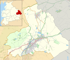
브레이스웰 앤드 브로그든
Bracewell and Brogden| 브레이스웰 앤드 브로그든 | |
|---|---|
 새 집 | |
랭커셔 내의 위치 | |
| 인구. | 244 (2011년) |
| OS 그리드 참조 | SD860484 |
| 민교구 |
|
| 구 | |
| 쉬레 현 | |
| 지역 | |
| 나라 | 잉글랜드 |
| 주권국 | 영국 |
| 포스트타운 | 스킵톤 |
| 우편번호 지구 | BD23 |
| 포스트타운 | 바노즈윅 |
| 우편번호 지구 | BB18 |
| 다이얼 코드 | 01282 |
| 경찰 | 랭커셔 |
| 불 | 랭커셔 |
| 구급차 | 노스웨스트 |
| 영국 의회 | |
Braceswell and Brogden은 잉글랜드 랭커셔 펜들 자치구의 웨스트 크레이븐 지역에 있는 시민 교구이다.2001년 인구조사에 따르면 인구는 238명으로 2011년 [1]인구조사에서 244명으로 소폭 증가했다.교구는 Braceswell(SD863485)과 Brogden(SD858472)을 포함하고 있으며, 역사적으로 둘 다 요크셔의 서쪽 승마 지역에 있었습니다.
지형학
브레이스웰: 개인 이름(Braegd 또는 Breij)에서 + 'well' = '봄 또는 개울' : 따라서 'Braegd's/Breij's spring or 냇물'
Brogden: '[3]개울의 계곡'
역사
Ribchester에서 Ilkley로 가는 오래된 로마 도로는 교구를 지나며, Bomber [4]Camp로 알려진 4세기 로마-영국 농장의 잔해는 Gisburn과의 경계 옆에 위치해 있습니다.
「 」를 참조해 주세요.
레퍼런스
- ^ UK Census (2011). "Local Area Report – Bracewell and Brogden Parish (1170215069)". Nomis. Office for National Statistics. Retrieved 8 February 2018.
- ^ Ekwall, Eilert (1960). The Concise Oxford Dictionary of English Place-names (4th ed.). Oxford: Clarendon Press.
- ^ Ekwall, Eilert (1960). The Concise Oxford Dictionary of English Place-names (4th ed.). Oxford: Clarendon Press.
- ^ Historic England. "Bomber Camp Romano-British farmstead (1013817)". National Heritage List for England. Retrieved 17 March 2016.
외부 링크
![]() Wikimedia Commons의 Braceswell 및 Brogden 관련 미디어
Wikimedia Commons의 Braceswell 및 Brogden 관련 미디어


