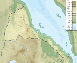
안파일 만
Bay of Anfile| 안파일 만 | |
|---|---|
| 좌표 | 14°46˚N 40°47°E / 14.767°N 40.783°E좌표: 14°46′N 40°47′E / 14.767°N 40.783°E/ |
| 네이티브 이름 | 암필라 만 |
| 해양/해양원 | 홍해 |
| 분지 국가 | 에리트레아 |
| 최대 길이 | 15km(9.3mi) |
| 최대폭 | 20km(12mi)[1] |
암필라 만 또는 안파일[2] 만(Bay of Anfile)은 에리트레아 해안에 있는 홍해에 있는 만이다.[3][4][5][6][7]
한도 섬(안투 게비르 또는 함다)과 게다 한도가 만을 마주보고 있다.[8]
참조
- ^ 구글어스
- ^ "Bay of Anfile". Mapcarta. Retrieved 14 October 2016.
- ^ Curtis, T. (1839). The London encyclopaedia, or, Universal dictionary of science, art, literature, and practical mechanics, by the orig. ed. of the Encyclopaedia metropolitana [T. Curtis]. p. 136. Retrieved 2015-04-13.
- ^ "National Maritime Museum". nmm.ac.uk. Archived from the original on 2008-06-27. Retrieved 2015-04-13.
- ^ Fisher, R.S. (1852). The book of the world. 2. pp. 1–624. Retrieved 2015-04-13.
- ^ "Untitled Document". libweb5.princeton.edu. Retrieved 2015-04-13.
- ^ Griffiths, R.; Griffiths, G.E. (1815). The Monthly Review. R. Griffiths. p. 1. Retrieved 2015-04-13.
- ^ "Hando". Mapcarta. Retrieved 30 March 2018.


