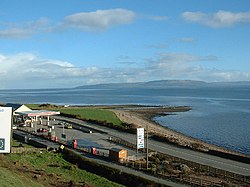
퀴글리 포인트
Quigley's Point퀴글리 포인트 린 우이 초글리 | |
|---|---|
마을 | |
 밴스 포인트, 퀴글리 포인트 | |
| 좌표: 55°07′30″N 7°11′50″w / 55.1249°N 7.1971°W좌표: 55°07′30″N 7°11′50″W / 55.1249°N 7.1971°W/ | |
| 나라 | 아일랜드 |
| 주 | 얼스터 |
| 카운티 | 도날 주 |
| 인구 (2016)[1] | 199 |
| 시간대 | UTC+0(WET) |
| • 여름(DST) | UTC-1(IST(WEST)) |
| 아일랜드 그리드 참조 | C513310 |
퀴글리 포인트(Irish:Rinn Ui Choigligh)[2]는 아일랜드 도날드 주(County Dodgal)에 있는 마을이다. 이니쇼웬의 동쪽 해안에 위치하고 러프 포일이 내려다보이는 이 마을은 때때로 그 이름의 타운랜드에 있기 때문에 지역적으로 "카로킬"(또는 "카로킬")로 알려져 있다.[3] 남쪽에는 데리시가 있고 북쪽에는 모빌과 그린캐슬의 마을이 있다. 자동차 페리는 그린캐슬과 매길리건을 여름에 연결한다. 이 지역을 흐르는 캐브리 강은 퀴글리 포인트에서 18세기 후반의 다리에 의해 확장된다.[4][5]
이 지역에 고대 정착지가 있었다는 증거로는 카브리 타운랜드의 석조 유적지와 카로우켈 타운랜드의 옛 크롬레흐 유적지가 있다.[6]
아일랜드 장로교회는 마을 근처 그린뱅크에 교회를 두고 있다. 그린뱅크 장로교회는 1862년 '고딕 영향' 양식으로 건립되었다.[7] 2003년 방화 사건으로 화재로 내장이 소실된 인근 장로교 회관은 이후 복원됐다.[8][9][10]
퀴글리 포인트의 인구는 2016년 인구조사 당시 199명으로 2011년 인구조사 때의 227명보다 줄었다.[1][11]
참고 항목
참조
- ^ a b "Sapmap Area - Settlements - Quigleys Point". Census 2016. Central Statistics Office (Ireland). Retrieved 13 June 2018.
- ^ "Rinn Uí Choigligh / Quigley's Point". logainm.ie. Placenames Database of Ireland. Retrieved 29 October 2021.
- ^ "Carrowkeel Townland, Co. Donegal". townlands.ie. Retrieved 29 October 2021.
- ^ "Donegal bridges gaps after 'all hands on deck' flood response". irishtimes.com. Irish Times. 2 September 2017. Retrieved 29 October 2021.
- ^ "Carrowkeel, Carrowkeel (Carrowkeel), Quigley's Point, Donegal". buildingsofireland.ie. National Inventory of Architectural Heritage. Retrieved 29 October 2021.
Triple-arch road bridge spanning the Cabry River, built c. 1780
- ^ Cody, Eamon, ed. (2002). Survey of the Megalithic Tombs of Ireland. Volume VI, County Donegal. Dublin: Government Stationery Office.
Megalithic tomb - unclassified [..] Carrowkeel [..] This feature is named 'Cromlech' on the original OS 6-inch map (1833-4). There are no visible remains at the site [..] Whatever the nature of this feature, it had apparently been removed by 1848, as it is named 'Site of Cromlech' on the OS 6-inch map of that date
- ^ "Greenbank Presbyterian Church, Carrowkeel, Tromaty, Quigley's Point, Donegal". buildingsofireland.ie. National Inventory of Architectural Heritage. Retrieved 29 October 2021.
- ^ "Police suspect gang of arson attacks". irishtimes.com. Irish Times. 15 July 2003. Retrieved 29 October 2021.
Greenbank Presbyterian church hall at Quigleys Point, Co Donegal, was destroyed in an early morning fire yesterday. The building, which is over 150 years old, was used as a social, community and badminton hall
- ^ "Arson attacks on church and masonic halls 'linked'". independent.ie. Independent News & Media. 15 July 2003. Retrieved 29 October 2021.
- ^ "Greenbank Presbyterian Church". inishowen4pc.com. Retrieved 29 October 2021.
The church hall was subject to an arson attack in 2003 but Greenbank rose up from the ashes with a wonderful new hall
- ^ "Quigleys Point (Ireland) Census Town". citypopulation.de. Retrieved 29 October 2021.


