이니시어러
Inishsirrer 도날 공항에 착륙할 준비를 하는 비행기에서 섬의 반쪽 | |
 이니시어러 | |
| 지리 | |
| 위치 | 대서양 |
| 좌표 | 55°06′54″N 8°19′55″w / 55.11500°N 8.33194°W좌표: 55°06′54″N 8°19′55″W / 55.11500°N 8.33194°W |
| 면적 | 0.43km2(0.17제곱 mi)[2] |
| 길이 | 1.6km(0.99mi) |
| 폭 | 0.4km(0.25mi) |
| 관리 | |
| 주 | 얼스터 |
| 카운티 | 도니갈 |
| 인구통계학 | |
| 인구 | 0 |
이니시어러(Irish: Iris Oirthir, '외딴[3] 섬'이라는 뜻)는 아일랜드 도네갈 주 그웨도어 해안가에 있는 작은 섬이자 타운랜드다.
지리
이니시어러는 그웨도어 해안에서 약 1km(0.6마일) 떨어져 있으며, 이니시메인에서 멀리 떨어져 있지 않다. 그것은 길이가 약 1.6킬로미터(1.0마일)이고 너비가 약 400미터(1,300피트)이다. 섬의 북쪽 끝 근처에는 정박하는 보트에 사용할 수 있는 모래 만이 있다.[citation needed]
역사
20세기 초에는 작은 공동체가 이니시러에 살았지만 오늘날 이 섬은 거주지가 없고 오래된 건물들이 대부분 파괴되어 있다.[4]
|
|
| ||||||||||||||||||||||||||||||||||||||||||||||||||||||||||||||||||||||||||||||
| 출처: Central Statistics Office. "CNA17: Population by Off Shore Island, Sex and Year". CSO.ie. Retrieved 12 October 2016. | ||||||||||||||||||||||||||||||||||||||||||||||||||||||||||||||||||||||||||||||||
낚시
이니시어러는 바닷가재 낚시를 하기에 좋은 곳으로 알려져 있었다.[5]
참고 항목
참조
- ^ "Inis Oirthir". Placenames Database of Ireland. Dublin City University. Retrieved 25 February 2016.
- ^ General Alphabetical Index to the Townlands and Towns, Parishes, and Baronies of Ireland: Based on the Census of Ireland for the Year 1851. Genealogical Publishing Com. 1861. p. 539. ISBN 9780806310527. Retrieved 25 February 2016.
- ^ Wallace Clark (2003). Donegal Islands. Dundurn. p. 35. ISBN 9781900935319. Retrieved 25 February 2016.
- ^ "The Lonely Homes of Inishsirrer". PhotosOfDonegal.com. Retrieved 18 April 2021.
- ^ Richard Deacon (1974). Islands of Ireland. Osprey. ISBN 9780850451689. Retrieved 25 February 2016.
이미지 갤러리

오래된 건물들

글래스 인근 해변에서 바라본 풍경
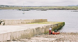
섬의 제트기

인적이 드문 마을


외부 링크
![]() 위키미디어 커먼스의 이니시러와 관련된 미디어
위키미디어 커먼스의 이니시러와 관련된 미디어