북부 국경 주
Northern Borders Province북부 국경 주 الحدود الشمالية 알샤말리야 | |
|---|---|
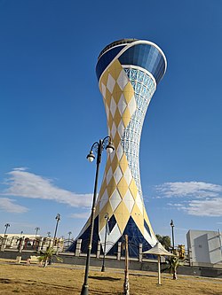
 북부 국경 지역의 수도인 아라르의 아라 워터 타워 | |
 사우디아라비아 북경계주 지도 | |
| 좌표:좌표: 30°0ºN 42°30ºE / 30.000°N 42.500°E / , | |
| 나라 | |
| 자본의 | '아르' |
| 자치구 | 3개 |
| 정부 | |
| • 거버전 | 파이잘 빈 칼리드 빈 술탄 빈 압둘아지즈 알 사우드 |
| 지역 | |
| • 합계 | 111,797km2(43,196평방마일) |
| 인구. (2010년) | |
| • 합계 | 375,310 |
| • 밀도 | 3.4/km2(8.7/120mi) |
| ISO 3166-2 | 08 |
The Northern Borders Region (Arabic: منطقة الحدود الشمالية Al-Ḥudūd Aš-Šamāliyya) is the least populated region of Saudi Arabia.그것은 이라크와 요르단과 국경을 접하고 있는 나라의 북쪽에 위치해 있다.면적은 111,797km이고2 인구는 2010년 [1]인구조사에서 320,524명이다.이 지역은 세 개의 주지사로 나뉩니다.아랄, 라파, 투레이프.수도는 아라르입니다.
인구.
| 연도 | Pop. | ±% p.a. |
|---|---|---|
| 1992 | 229,060 | — |
| 2004 | 279,971 | +1.69% |
| 2010 | 321,880 | +2.35% |
| 2018 | 375,310 | +1.94% |
| 출처:[2] | ||
행정 부문
이 지역은 4개의 [1]주로 나뉜다.
「 」를 참조해 주세요.
레퍼런스
- ^ a b "The Sixteenth Services Guide 2017:Northern Borders Region" (PDF). Central Authority for Statistics.
- ^ "Saudi Arabia: Regions & Major Cities - Population Statistics, Maps, Charts, Weather and Web Information". www.citypopulation.de.


