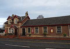
세인트 그레고르, 서스캐처원
St. Gregor, Saskatchewan성 그레고르 | |
|---|---|
마을 | |
 | |
 성 그레고르  성 그레고르 | |
| 좌표:52°10′36″n 104°49′35″w/52.17667°N 104.82639°W좌표: 52°10′36″N 104°49′35″W / 52.17667°N 104.82639°W | |
| 나라 | 캐나다 |
| 주 | 서스캐처원 |
| 인구조사과 | 10 |
| 농촌시 | 성 베드로 |
| 우체국 설립 | 해당 없음 |
| 통합(마을) | 해당 없음 |
| Incorporated town) | 해당 없음 |
| 정부 | |
| • 시장 | 더그 호게만 |
| • 관리자 | 달린 쿠즈 |
| • 관리 기관 | 세인트 그레고르 마을 평의회 |
| 면적 | |
| • 합계 | 0.91km2(0.35sq mi) |
| 인구 (2022) | |
| • 합계 | 104 |
| • 밀도 | 123.7/km2(320/sq mi) |
| 시간대 | CST |
| 우편번호 | S0K 3X0 |
| 지역 번호 | 306 |
| 고속도로 | 화이 667번길 |
| [1][2][3][4] | |
세인트 그레고르(2016년 인구: 97년)는 캐나다 서스캐처원 주의 시골 자치구 내 마을이다. 피터 369번과 인구조사부 15번.5번 고속도로 왓슨 타운에서 서쪽으로 약 20km 떨어져 있다.
역사
1920년 3월 26일 성 그레고르는 마을로 편입되었다.[5]
인구통계학
2021년 인구조사에서, 성 마을.게르고르는 104명으로 2016년 인구 97명보다 +7.2%의 변화를 기록했다.[8]
캐나다 통계청이 실시한 2016년 인구조사에서 성 마을.그레고르는 총 48개 민간 주거지 중 42개 지역에서 97명의 인구를 기록했는데, 이는 2011년 인구 98명보다 -1% 증가한 수치다.국토면적이 0.91km2(0.35sqmi)로 2016년 인구밀도가 106.6/km2(276.1/sqmi)에 달했다.[9]
2011년 인구조사에서 성 마을그레고르는 98명의 인구를 기록했는데, 이는 2006년 인구 102명에서 -3.9%의 변화였다.국토면적이 0.91km2(0.35sqmi)로 2011년 인구밀도가 107.7km/km2(278.9/sqmi)에 달했다.[10]
참고 항목
참조
- ^ National Archives, Archivia Net, Post Offices and Postmasters
- ^ Government of Saskatchewan, MRD Home, Municipal Directory System, archived from the original (– Scholar search) on November 21, 2008
{{citation}}:외부 링크 위치format= - ^ Canadian Textiles Institute. (2005), CTI Determine your provincial constituency, archived from the original on 2007-09-11
- ^ Commissioner of Canada Elections, Chief Electoral Officer of Canada (2005), Elections Canada On-line
- ^ "Urban Municipality Incorporations". Saskatchewan Ministry of Government Relations. Archived from the original on October 15, 2014. Retrieved June 1, 2020.
- ^ "Saskatchewan Census Population" (PDF). Saskatchewan Bureau of Statistics. Archived from the original (PDF) on September 24, 2015. Retrieved May 31, 2020.
- ^ "Saskatchewan Census Population". Saskatchewan Bureau of Statistics. Retrieved May 31, 2020.
- ^ "Census Profile". 2022. Retrieved February 11, 2022.
{{cite web}}:first=행방불명의last=(도움말) - ^ "Population and dwelling counts, for Canada, provinces and territories, and census subdivisions (municipalities), 2016 and 2011 censuses – 100% data (Saskatchewan)". Statistics Canada. February 8, 2017. Retrieved May 30, 2020.
- ^ "Population and dwelling counts, for Canada, provinces and territories, and census subdivisions (municipalities), 2011 and 2006 censuses (Saskatchewan)". Statistics Canada. June 3, 2019. Retrieved May 30, 2020.
외부 링크
- 도시명함 Saskatchewan - 성 마을그레고르
- 서스캐처원 시티 & 타운 맵
- Saskatchewan Gen Web - 원룸 스쿨 프로젝트
- 우체국 및 우체국장 - ArchiviaNet - 캐나다 도서관 및 보관소
- 사스카처완 젠 웹 지역
- 온라인 역사 지도 디지털화 프로젝트
- 지오 네임스 쿼리
- 2001년 커뮤니티 프로파일