파툼타니 주
Pathum Thani province파툼 타니 ปทุมธานี | |
|---|---|
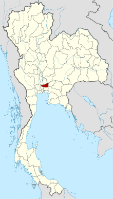
 파툼타니 주를 하이라이트한 태국 지도 | |
| 나라 | 태국. |
| 지역 | 태국 중부 |
| 자본 | 파툼 타니 |
| 가장 큰 도시 | 랑싯 |
| 정부 | |
| • 주지사 | 나롱삭 오소타나콘 (2021년 10월 이후) |
| 면적 | |
| • 합계 | 1,526 km2(589 sq mi) |
| 면적 순위 | 70위 |
| 인구 (2019)[2] | |
| • 합계 | 1,163,604 |
| • 순위 | 18위 |
| • 밀도 | 763/km2(1,980/sq mi) |
| • 밀도 순위 | 5위 |
| 인간성과지수 | |
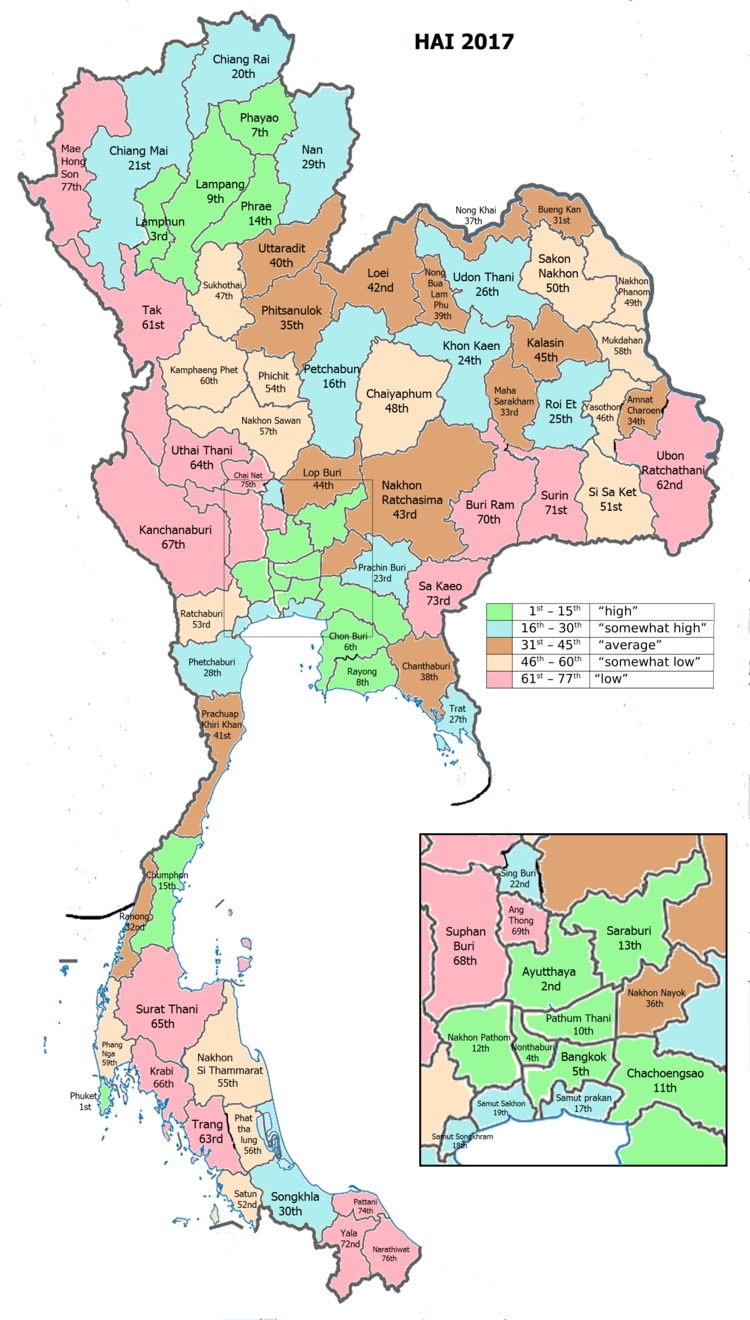
| • HAI(2017년) | 0.6384 "높음" 10위 |
| 시간대 | UTC+7(ICT) |
| 우편번호 | 10xxx |
| 호출 코드 | 02 |
| ISO 3166 코드 | TH-13 |
| 웹사이트 | www |
파툼 타니(Tai: ปทมมธีี, [pa.tʰm tʰāā]]] 발음)는 태국의 중부 지방(changwat) 중 하나이다.인접 지방은 (시계방향으로 북쪽에서):아유타야, 사라부리, 나콘나요크, 차쵸엥사오, 방콕, 논타부리.
지방은 방콕의 북쪽에 있으며 방콕 대도시권의 일부분이다.많은 곳에서는 경계선의 양쪽이 똑같이 도시화되어 있어 두 지방의 경계가 눈에 띄지 않는다.파툼타니타운이 행정구역이지만, 타냐부리 구의 반랑싯(Ban Rangsit)은 도내에서 가장 인구가 많은 곳이다.[4]
파툼 타니는 몬족이 많이 거주하는 오래된 지방으로 186개의 사원과 공원이 있다.드림월드 놀이공원이 여기 있다.[citation needed]
지리
도는 수도를 흐르는 차오프라야 강의 낮은 충적대에 놓여 있다.많은 운하(khong)들이 도를 건너 논에 먹이를 주고 있다.지방에는 삼림지대가 없다.[5]
역사
파툼 타니 지방은 아유타야의 나라이왕이 통치한 이래 적어도 300년 이상 정착해 있다.1659년, 망난타미트는 모타마 마을에서 몬족을 데려왔다.버마 전쟁에서 피난한 나라이왕은 몬족에게 반삼촉에 정착지를 주었다.몇 년 후, 라마 2세의 통치 기간에는 모타마 마을에서 태국으로 몬족들이 "몬야이"라고 불리는 대이동이 있었다.그는 또한 반삼협에 살기 위해 몬족들 중 일부를 만들었다.작은 공동체로부터 반삼촉은 후에 마을 샘촉이 되었다.
이후, 1815년 8월 23일, 라마 2세는 샘크(Sam Khok)의 이름을 "Pratum Tani"라는 마을로 바꾸었다.1918년 라마 6세는 '동네' 대신 '도'라는 단어를 쓰도록 명령하고 명칭의 철자를 '프라툼 타니'에서 '파툼 타니'로 바꾸었다.
1932년, 라마 7세 때 타냐부리 지방을 붕괴시켜 파툼 타니를 생각해 내라고 명령했다.파툼타니 지방은 현재와 같이 이 규칙을 7개 구역으로 나누었다.
기호
도표에는 두 개의 벼줄기가 구부러진 분홍색 연꽃이 그려져 있어 도의 풍요를 상징한다.지방나무는 인도의 산호나무(Erythrina variegata)이다.지방 꽃은 연꽃이다.[citation needed]
교육 및 기술
파툼 타니는 매우 높은 수준의 고등 교육 기관, 특히 과학기술 분야의 기관들이 밀집되어 있다.이를 통해 산업단지와 연구시설(태국과학공원 포함)이 많이 들어서 지역의 교육 및 기술거점이 되고 있다.[citation needed]
- 학회
- National Science Museum, Asian Institute of Technology, Bangkok University, Eastern Asia University, North Bangkok University (Rangsit), Pathumthani University, Rajamangala University of Technology, Rangsit University, Shinawatra University, Sirindhorn International Institute of Technology, Thammasat University (Rangsit Center, and Valaya Alongkorn - 라자바흐트 대학).
- 연구기관
- Thailand Science Park, National Science and Technology Development Agency (NSTDA), National Center for Genetic Engineering and Biotechnology (BIOTEC), National Metal and Materials Technology Center (MTEC), National Nanotechnology Center (NANOTEC), National Electronics and Computer Technology Center (NECTEC), Thai Microelectronics Center (TMEC), ThaIland Institute of Scientific and Technical Research, TOT(토트)
- 공업단지
- 소프트웨어 파크 태국(논타부리에서, 빠툼타니에서 남서쪽으로), Nava Nakorn 산업 촉진 지구(1376년에이커/5.6km2), Bangkadi 산업 단지(470에이커/190km2), 테크노 Thani(는"기술시"과학 기술부에 의해 통치), 산업 공원 인근 국가인 아유타야와 논타부리, 지방의 번호입니다..
행정 구역
도
지방은 7개 지구(암포)로 나뉜다.그 지역은 60개의 공동체와 529개의 마을로 더 세분된다.
지방 정부
2020년 9월 29일 현재 도내에는 Pathum Tani 지방행정기구 - PAO (ongkan borihan suan changwat)과 29개 시(사반) 지역이 있다.랑시트는 도시(사반 나콘)의 지위를 가지고 있다.10개 이상의 도시(사반무앙)와 18개 하위 자치구(사반탐봉)가 있다.[2]
| 시 | 1 | 랑싯[6] | 85,260 |
| 마을 문. | 사람 | ||||
| 1 | 타 클롱[7] | 78,108 | 6 | 꽝 이토[8] | 32,708 |
| 2 | 람삼개오[9] | 66,003 | 7 | 산안락[10] | 31,350 |
| 3 | 라트사와이[11] | 65,906 | 8 | 방쿠와트 | 28,349 |
| 4 | 크롱 루앙[12] | 62,615 | 9 | 파툼 타니[13] | 23,633 |
| 5 | 쿠호트[14] | 44,274 | 10 | 방카디[15] | 13,987 |
| 아지구문. | 사람 | ||||
| 1 | 타냐부리[16] | 62,990 | 10 | 방오에이 | 10,828 |
| 2 | 방펀[17] | 25,509 | 11 | 라행 | 10,445 |
| 3 | 락호크[18] | 21,883 | 12 | 크롱 프라 우돔 | 7,995 |
| 4 | 람루크카[16] | 18,377 | 13 | 샘 호크[19] | 6,963 |
| 5 | 방레야[20] | 14,756 | 14 | 방루앙[16] | 6,314 |
| 6 | 방하능[21] | 14,557 | 15 | 장락야 | 6,260 |
| 7 | 반마이[22] | 14,447 | 16 | 쿠왕[23] | 6,000 |
| 8 | 반 클랑[24] | 12,326 | 17 | 람사이[16] | 2,657 |
| 9 | 농삼왕 | 11,016 | 18 | 농수아[16] | 2,901 |
시외 지역은 35개 구에서 관리한다.
조직 - SO(ongkan borihan suan tambon)[25]
| 자치구 | 커뮤니티 | |
| 랑싯[26] | 81 | |
| 람삼개오[27] | 70 | |
| 크롱 루앙[28] | 54 | |
| 쿠호트[29] | 31 | |
| 꽝 이토[30] | 37 | |
| 파툼 타니[31] | 28 | |
| 방카디[32] | 18 |
인적성취도지수 2017
| 건강 | 교육 | 고용 | 수입 |
| 4 | 11 | 38 | 13 |
| 주택 | 가족 | 운송 | 참여 |
 |  | ||
| 68 | 8 | 3 | 76 |
| HAI 2017의 값이 0.6384인 도 파툼 타니는 순위에서 10위를 차지하고 있다. | |||
2003년부터 태국의 유엔개발계획(UNDP)은 인간개발의 8대 핵심영역을 모두 포괄하는 종합지수인 HII(Human Achievement Index)를 이용해 국가 이하의 인간개발 진척상황을 추적해왔다.국가경제사회개발원(NESDB)이 2017년부터 이 업무를 이어받았다.[3]
| 순위 | 분류 |
| 1 - 15 | "높음" |
| 16 - 30 | "높음" |
| 31 - 45 | "평균" |
| 45 - 60 | "낮음" |
| 61 - 77 | "낮음" |
| 도 및 HAI 2017 순위와 함께 지도 |
 |
참조
- ^ Advancing Human Development through the ASEAN Community, Thailand Human Development Report 2014, table 0:Basic Data (PDF) (Report). United Nations Development Programme (UNDP) Thailand. pp. 134–135. ISBN 978-974-680-368-7. Retrieved 17 January 2016, Data has been supplied by Land Development Department, Ministry of Agriculture and Cooperatives, at Wayback Machine.
{{cite report}}: CS1 maint : 포스트스크립트(링크)[데드링크] - ^ a b "สถิติทางการทะเบียน" [Registration statistics]. bora.dopa.go.th. Department of Provincial Administration (DOPA). December 2019. Retrieved 22 September 2020.
Download จำนวนประชากร ปี พ.ศ.2562 - Download population year 2019
- ^ a b 국가경제사회개발원(NESDB)의 2017년 인적성취도지수 1-40페이지 지도 1-9페이지, 2019년 9월 14일자, ISBN 978-974-9769-33-1
- ^ "Population Statistics 2008". Department of Provincial Administration. Archived from the original on 2010-03-25. Retrieved 2010-06-28.
Pathum Thani town population 18,843; Rangsit town population 76,843
- ^ "ตารางที่ 2 พี้นที่ป่าไม้ แยกรายจังหวัด พ.ศ.2562" [Table 2 Forest area Separate province year 2019]. Royal Forest Department (in Thai). 2019. Retrieved 6 April 2021, information, Forest statistics Year 2019
{{cite web}}: CS1 maint : 포스트스크립트(링크) - ^ "ประกาศกระทรวงมหาดไทย เรื่อง เปลี่ยนแปลงฐานะเทศบาลเมืองรังสิต อำเภอธัญบุรี จังหวัดปทุมธานี เป็นเ ทศบาลนครรังสิต พ.ศ.๒๕๕๔" [Announcement from the Ministry of Interior Re: Change Rangsit town municipality, Thanyaburi district, Pathum Thani province to Rangsit city municipality B.E.2554 (2011).] (PDF). Royal Thai Government Gazette. 128 (Special 61 Ngor): 42. 1 June 2011. Retrieved 31 October 2019.
- ^ "พระราชฤษฎีกา จัดตั้งเทศบาลเมืองท่าโขลง พ.ศ.๒๕๔๔" [Royal Decree: Establish of Tha Khlong town municipality B.E.2544 (2001)] (PDF). Royal Thai Government Gazette. 118 (93 Kor): 25–27. 9 October 2001. Retrieved 12 December 2019.
- ^ "ประกาศกระทรวงมหาดไทย เรื่อง เปลี่ยนแปลงฐานะเทศบาลตำบลบึงยี่โถ อำเภดธัญบุรี จังหวัดปทุมธาบี เป็นเทศบาลเมืองบึงยี่โถ พ.ศ.๒๕๕๕" [Notification of the Ministry of Interior: Change status of Bueng Yi Tho subdistrict municipality, Thanyaburi district, Pathum Thani province to Buen Yi Tho town municipality B.E.2555 (2012)] (PDF). Royal Thai Government Gazette. 129 (Special 13 Ngor): 44. 11 January 2012. Retrieved 12 December 2019.
- ^ "ประวัติความเป็นมา" [History]. lamsamkaeo.go.th (in Thai). 2020. Retrieved 30 October 2020.
Lam Sam Kaeo SAO upgraded to Lam Sam Kaeo town municipality on 1 August 2007.
- ^ "ประกาศกระทรวงมหาดไทย เรื่อง เปลี่ยนแปลงฐานะเทศบาลตำบลสนั่นรักษ์ อำเภดธัญบุรี จังหวัดปทุมธาบี เป็นเทศบาลเมืองสนั่นรักษ์ พ.ศ.๒๕๔๗" [Notification of the Ministry of Interior: Change status of Sanan Rak subdistrict municipality, Thanyaburi district, Pathum Thani province to Sanan Rak town municipality B.E.2547 (2004)] (PDF). Royal Thai Government Gazette. 121 (Special 78 Ngor): 1–2. 19 July 2004. Retrieved 12 December 2019.
- ^ "Number of local government organizations: Summary elevating local authorities". dla.go.th. Department of Local Administration (DLA). 23 September 2011. Retrieved 25 September 2020.
No.3.1 Established Lat Sawai Subdistrict Administrative Organization (SAO), Lam Luk Ka district, Pathum Thani province is Lat Sawai town municipality, effectively 1 October 2011.
- ^ "ประกาศกระทรวงมหาดไทย เรื่อง เปลี่ยนแปลงฐานะเทศบาลตำบลคลองหลวง อำเภดคลองหลวง จังหวัดปทุมธาบี เป็นเทศบาลเมืองคลองหลวง พ.ศ.๒๕๔๘" [Notification of the Ministry of Interior: Change status of Khlong Luang subdistrict municipality, Khlong Luang district, Pathum Thani province to Khlong Luang town municipality B.E.2548 (2005).] (PDF). Royal Thai Government Gazette. 122 (Special 84 Ngor): 6. 14 September 2005. Retrieved 12 December 2019.
- ^ "พระราชกฤษฎีกา จัดตั้งเทศบาลเมืองปทุมธานี จังหวัดปทุมธานี พุทธศักราช ๒๔๗๙" [Royal Decree: Establishing of Pathum Thani town municipality, Pathum Thani province, Buddhist Era 2479 (1936).] (PDF). Royal Thai Government Gazette. 53: 828–831. 29 November 1936. Retrieved 10 October 2020.
- ^ "พระราชกฤษฎีกาจัดตั้งเทศบลเมืองคูคต พ.ศ.๒๕๓๙" [Royal Decree: Establish of Khu Khot town municipality B.E.2539 (1996).] (PDF). Royal Thai Government Gazette. 113 (5 Kor): 4–7. 6 March 1996. Retrieved 31 October 2019.
- ^ "ประกาศกระทรวงมหาดไทย เรื่อง เปลี่ยนแปลงฐานะเทศบาลตำบลบางกะดี อำเภดเมืองปทุมธานี จังหวัดปทุมธาบี เป็นเทศบาลเมืองบางกะดี" [Notification of the Ministry of Interior: Change status of Bang Kadi subdistrict municipality, Mueang Pathum Thani district, Pathum Thani province to Bang Kadi town municipality.] (PDF). Royal Thai Government Gazette. 137 (Special 204 Ngor): 10+11. 8 September 2020. Retrieved 25 September 2020.
- ^ a b c d e "พระราชกฤษฎีกา เปลี่ยนแปลงฐานะของสุขาภิบาลเป็นเทศบาล พ.ศ.๒๕๔๒" [Royal Decree: Change Sanitation district to Municipality Act B.E.2542.] (PDF). Royal Thai Government Gazette. 116 (9 Kor): 1–4. 24 February 1999. Retrieved 10 October 2020, effective 25 May 1999.
{{cite journal}}: CS1 maint : 포스트스크립트(링크) - ^ "Number of local government organizations: Summary elevating local authorities". dla.go.th. Department of Local Administration (DLA). 2 September 2011. Retrieved 9 September 2020.
No.4.14 Established Bang Phun Subdistrict Administrative Organization (SAO), Mueang Pathum Thani district, Pathum Thani province is Bang Phun subdistrict municipality, effectively 30 September 2011.
- ^ "ประวัติหน่วยงาน" [History of the Agency]. lakhok.go.th (in Thai). 2020. Retrieved 30 October 2020.
Lak Hok SAO upgraded to Lak Hok subdistrict municipality on 24 August 2007.
- ^ "Number of local government organizations: Summary elevating local authorities". dla.go.th. Department of Local Administration (DLA). 4 August 2011. Retrieved 25 September 2020.
No.4.2 Established Sam Khok Subdistrict Administrative Organization (SAO), Sam Khok district, Pathum Thani province is Sam Khok subdistrict municipality, effectively 1 October 2011.
- ^ "Number of local government organizations: Summary elevating local authorities". dla.go.th. Department of Local Administration (DLA). 2 September 2011. Retrieved 17 September 2020.
No.4.12 Established Bang Duea Subdistrict Administrative Organization (SAO), Mueang Pathum Thani district, Pathum Thani province is Bang Duea subdistrict municipality, effectively 30 September 2011.
- ^ "Number of local government organizations: Summary elevating local authorities". dla.go.th. Department of Local Administration (DLA). 30 September 2011. Retrieved 30 October 2020.
No.4.49 Established Bang Khayaeng Subdistrict Administrative Organization (SAO), Mueang district, Pathum Thani province is Bang Khayaeng subdistrict municipality, effectively 30 September 2011.
- ^ "Number of local government organizations: Summary elevating local authorities". dla.go.th. Department of Local Administration (DLA). 4 August 2011. Retrieved 25 September 2020.
No.4.1 Established Ban Mai Subdistrict Administrative Organization (SAO), Mueang Pathum Thani district, Pathum Thani province is Ban Mai subdistrict municipality, effectively 1 October 2011.
- ^ "Number of local government organizations: Summary elevating local authorities". dla.go.th. Department of Local Administration (DLA). 2 September 2011. Retrieved 17 September 2020.
No.4.11 Established Khu Kwang Subdistrict Administrative Organization (SAO), Lat Lum Kaeo district, Pathum Thani province is Khu Kwang subdistrict municipality, effectively 30 September 2011.
- ^ "Number of local government organizations: Summary elevating local authorities". dla.go.th. Department of Local Administration (DLA). 2 September 2011. Retrieved 9 September 2020.
No.4.13 Established Ban Klang Subdistrict Administrative Organization (SAO), Mueang Pathum Thani district, Pathum Thani province is Ban Klang subdistrict municipality, effectively 30 September 2011.
- ^ 도 행정학과(DOPA), 2019년 12월 20일 현재 SAO 정보 목록 5,324건, 1994년(1호), 1995년(19호), 1996년(10호), 1997년(5호)에 35건의 SAO 정보(제216호-2151호)가 제정되었다.
- ^ "ด้านชุมชน" [Community side]. rangsit.org (in Thai). 2020. Retrieved 30 October 2020.
81 communities.
- ^ "กลุ่มอค์กร" [Organization groups]. lamsamkaeo.go.th (in Thai). 2020. Retrieved 30 October 2020.
70 communities.
- ^ "ชุมชน" [Communities]. khlongluang.go.th (in Thai). 2020. Retrieved 30 October 2020.
54 communities.
- ^ "ข้อมูลชุมชน" [Community information]. khukhot.go.th (in Thai). 2020. Retrieved 30 October 2020.
31 communities.
- ^ "1. สภาพทั่วไป (5.3)" [1. General (5.3)]. buengyitho.go.th (in Thai). 2020. Retrieved 30 October 2020.
37 communities.
- ^ "ข้อมูลเทศบาล" [Municipal information]. muangpathum.org (in Thai). 2020. Retrieved 30 October 2020.
28 communities.
- ^ "ชุมชน" [Communities]. bangkadi.go.th (in Thai). 2020. Retrieved 30 October 2020.
18 communities.
외부 링크
 위키보이지의 파툼 타니 여행 가이드
- 파툼 타니; 파툼 타니
- 컬리의 파툼 타니의 대학과 대학


