구빈시앙고헬레
Givenchy-en-Gohelle구빈시앙고헬레 | |
|---|---|
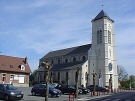
 17세기 에글리제 생마르탱 | |
| 좌표:50°23°37°N 2°462323eE/50.3936°N 2.7731°E좌표: 50°23°37°N 2°46°23°E / 50.3936°N 2.7731°E / | |
| 나라 | 프랑스. |
| 지역 | 오츠드프랑스 |
| 부서 | 파드칼레 |
| 아롱디스망 | 렌즈 |
| 칸톤 | 리에빈 |
| 인터커뮤니티 | CA 렌즈-리뱅 |
| 정부 | |
| • 시장(2020–2026) | 피에르[1] 세네찰 |
| 지역 1 | 5.95km2(2.30평방마일) |
| 인구. (2019년 [2]1월) | 2,030 |
| • 밀도 | 340/km2(880/140mi) |
| 시간대 | UTC+01:00 (CET) |
| • 여름 (DST) | UTC+02:00 (CEST) |
| INSEE/우편번호 | 62371 / 62580 |
| 승진 | 48 ~ 165 m (162 ~486 피트) (평균 97m 또는 318ft) |
| 1 프랑스2 토지 등록부 데이터는 호수, 연못, 빙하 > 1km(0.386 평방 미 또는 247 에이커)와 강 하구를 제외한다. | |
Givenchy-en-Gohelle (French pronunciation: [ʒivɑ̃ʃi ɑ̃ goɛl];Picard: Givinchy-in-Gohelle)는 프랑스 [3]오트드프랑스 지역 파스데칼레 주에 있는 코뮤니티입니다.비미 능선 전투와 제1차 세계대전 당시 실종된 캐나다 병사들을 기리는 캐나다 국립 비미 기념비에서 북쪽으로 1.8km(1.1mi) 떨어진 곳에 위치해 있으며 묘지도 [4]알려지지 않았다.그 마을은 제1차 세계대전 중에 파괴되었다가 [5]전쟁 후에 재건되었다.
지리
Givenchy-en-Gohelle은 Aras에서 북쪽으로 6마일(9.7km) 떨어진 D51과 D55 도로가 만나는 곳에 위치한 큰 농촌 마을입니다.서쪽은 수체스 주, 북서쪽은 앙그레스 주, 북쪽은 리에뱅 주, 동쪽은 아비온 주, 남동쪽은 비미 주와 인접해 있다.
Bois de Givenchy 또는 Givenchy 숲은 북쪽에 있는 공동체의 대부분을 덮고 있습니다.농산물의 범위를 넓히기 위해, Givenchy-en-Gohelle의 공동체는 포도(샤르도네와 피노그리스)를 심었습니다.첫 포도 수확은 2000년에 이루어졌다.
제1차 세계 대전
제1차 세계 대전 동안, Givenchy-en-Gohelle은 아라스 전투 동안 독일과 연합군 사이의 최전선에 있었고, 특히 1917년 비미 능선 전투에서 심각한 피해를 입었다.제1차 세계대전의 대부분 기간 동안, 마을은 독일과 영국의 터널링 부대 사이의 지속적인 지하 전투의 장소이기도 했다.Givenchy-en-Gohelle은 1917년 4월 13일 제2캐나다사단에 의해 함락되었다.150명 이상의 전쟁 사상자(1914~1918년)가 이곳 캐나다 묘지에서 추모되고 있으며, 비미 능선 전투의 109명이 이곳에 [6]묻혀 있다.
2017년 [7]4월 9일 비미 능선 전투 100주년 기념 행사가 마을 근처의 캐나다 국립 비미 기념관에서 열렸다.행사 전 예상으로는 최대 3만 명이 [8]참석할 것으로 보인다.
2017년 4월 초, 마을은 500개의 캐나다 [5][9]국기로 장식되었다.
인구.
| 연도 | Pop. | ±% p.a. |
|---|---|---|
| 1968 | 1,555 | — |
| 1975 | 1,627 | +0.65% |
| 1982 | 1,755 | +1.09% |
| 1990 | 1,973 | +1.47% |
| 1999 | 2,051 | +0.43% |
| 2007 | 2,093 | +0.25% |
| 2012 | 2,024 | −0.67% |
| 2017 | 1,947 | −0.77% |
| 출처: INSEE[10] | ||
관심장소
- 프랑스에서 [4]사망한 것으로 추정되는 제1차 세계 대전 캐나다인의 사망과 실종을 기념하는 캐나다 국립 비미 기념관입니다.
- 성모 마리아 교회.마틴, 17세기 사람이에요.
- 영연방 전쟁 묘지 위원회 캐나다 기념 및 공동묘지.
「 」를 참조해 주세요.
레퍼런스
- ^ "Répertoire national des élus: les maires". data.gouv.fr, Plateforme ouverte des données publiques françaises (in French). 9 August 2021.
- ^ "Populations légales 2019". The National Institute of Statistics and Economic Studies. 29 December 2021.
- ^ INSEE community 파일
- ^ a b "Canadian National Vimy Memorial, France". The Great War UK. The Great War UK. 2015. Retrieved 31 March 2017.
The ridge runs in a direction from Givenchy-en-Gohelle in the north-west to Farbus in the south-east.
- ^ a b "French village decked out in Canadiana to mark Vimy Ridge centennial". 5 April 2017.
- ^ Canada, Veterans Affairs. "Givenchy-en-Gohelle Canadian Cemetery - Memorials In France - First World War Memorials Overseas - Memorials Overseas - Memorials - Remembrance - Veterans Affairs Canada".
- ^ "Vimy Ridge: Royals commemorate defining WW1 battle". BBC. 9 April 2017. Retrieved 9 April 2017.
- ^ Siekierska, Alicja (31 March 2017), Toronto photographer to open exhibition to commemorate battle of Vimy Ridge, Toronto Star, retrieved 1 April 2017
- ^ "French town plastered with over 500 Canadian flags for Vimy Ridge anniversary".
- ^ 인구사적부 1968, INSEE
외부 링크
- CWGC는 교회 묘지에 묻혔다.
- 소체스의 CWGC 묘지
- CWGC 사이트의 Vimy 메모리얼
- 지역 와인 재배자 웹사이트 (프랑스어)
- 공식 커뮤니티 웹사이트 (프랑스어)
- 지역별 웹사이트 (프랑스어)


