갭 오브 던로
Gap of Dunloe| 갭 오브 던로 | |
|---|---|
| 둔 로이치 | |
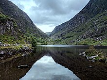
 갭 오브 갭의 블랙 호수에서 갭의 우두머리 쪽을 남쪽으로 바라보고 있다. | |
| 표고 | 241미터(791피트)[1] |
| 통과자 | 공설로[2] |
| 위치 | 아일랜드 케리 주 |
| 범위 | |
| 좌표 | 52°1′00″N 9°38′7.8″W / 52.01667°N 9.635500°W좌표: 52°1′00″N 9°38′7.8″W / 52.01667°N 9.635500°W/ |
| 토포 지도 | OSI Discovery 78 |
 아일랜드의 위치 | |
TheGapDunloe의(아일랜드에서:Dún Lóich, 의미 'Lóich의 거점인 '), 또한 Bearna로 좁은 산길 케리 주, 아일랜드,, 자금산 그룹으로부터 서쪽에서 MacGillycuddy의 Reeks 산맥을 구분하는에 쪽을 실행하는 Choimín(의미"그 평민에 대한 격차"또는" 작은 중공에 대한 격차")[3]를 기록했다.ge 동쪽에 그곳은 경치 때문에 케리 후보가 가장 많이 찾는 관광지 중 하나이다.[4]
이름 지정

'둔로'라는 용어는 아일랜드어 '둔로이치(Dunloe valley)의 요새 또는 거점(Dunloe valley를 흐르는 roe 강도 같은 출처에서 이름을 따온 것)이라는 뜻의 두른로이치(Dunloich)의 영어식어인 것으로 생각된다.[5] According to the Annals of Clonmacnois, Keating and the Lebor Gabála Érenn (LGE), Deala (or Dela) Mac Lóich was the father of the five chieftains of the returning Fir Bolg (Slainghe, Gann, Genann, Seangann, and Rudhraighe), who conquered Ireland and divided it into five provinces, each ruled by one brother.[6] 사대부 연보에 따르면 피르 볼그는 기원전 3266년부터 3303년까지 37년간 아일랜드를 다스렸으나,[7] 돌아온 투아타 데 다난에게 스스로 패배하였다.[5]
지리
_Gap_of_Dunloe.jpg)
갭 오브 던로(Gap of Dunlo)는 아일랜드의 마지막 빙하시대 때 500m가 넘는 것으로 추정되는 템플테노 아이스캡의 일부인 블랙밸리의 빙하가 갭의 머리를 뚫고 U자형 계곡을 조각해 북쪽으로 이동하는 '글래시컬 균열'의 결과로 2만5000년 전 형성됐다.[8][9][10]
이 고개는 맥길리쿠디의 리크(서쪽)의 올드 레드 샌드스톤 산맥과 퍼플 마운틴 그룹(동쪽) 사이에 남북으로 뻗어 있다. 갭을 통과하는 남북 도로는 알려진 대로 북쪽의 케이트 키어니 코티지(Kate Kearney's Cottain)에서 241m(791피트)의 갭 헤드(Head of the Gap)까지,[1] 남쪽의 블랙 밸리(Black Valley)에 있는 브랜든 경의 코티지(Lord's Cottainant)까지 이어진다. 케이트 키어니 코티지(Kate Kearney's Coatant)에서 브랜든 경 코티지(Lord Centre)까지의 도로는 총 11km(7마일)이며, 총 고도 200m(650피트)가 변화한다.[1]
The Gap 내에는 (북쪽에서 남쪽으로) 다섯 개의 호수가 있다. Coosaun Lough, Black Lake, Cushnavaly Lake, Augger Lough, Black Lough. 그 호수들은 뢰 강으로 연결되어 있다. 첫 번째 두 개의 다리 사이, Coosaun Lough와 Black Lake는 소원이 이루어지기를 바라는 다리라고 한다.[11][12] 아우거호 북쪽 끝에 있는 돌다리, 블랙루프 북쪽 끝에 있는 돌다리도 망루 지점이다.
접근
.jpg)
북쪽의 케이트 키어니 코티지(Kate Kearney's Countain)에서 남쪽의 블랙 밸리로 들어가는 갭 오브 던로(Gap of Dunlo)를 통과하는 도로는 공공도로로,[2] 케리 카운티 의회의 책임하에 있다.[15] 2005년, 개인 차량 운영자들은 관광객들이 도로를 운전하는 것을 막았다는 비난을 받았다.[16] 론리 플래닛은 2018년 아일랜드 가이드북을 통해 이 도로가 공공장소임을 명확히 했다.[13][14]
.jpg)
The true Head of the Gap (at V872838), can be accessed from the north by driving past Kate Kearney's Cottage, and from the south by driving to Moll's Gap and then continuing east on the R568 road until a small side-road (at V853774, sometimes labelled "Gearhasallagh" after the townsland, on maps), descends steeply north into the Black Valley and th브랜든 경의 오두막 쪽으로 서쪽으로 방향을 바꾸다가 북쪽으로 방향을 틀면 실제 간극의 우두머리 쪽으로 방향을 바꾸는데, 이 경로는 사이클 선수들에게 인기 있는 [17][18]던로-블랙 밸리-몰스 갭 지역의 킬러니-갭 55km 고리의 일부다.[19]
Dunlo 도로의 Gap을 통과하는 공공 도로가 Gap의 Head에 도달함에 따라 그것은 좁고 구불구불해지고 차량이 지나가기 어려워져 안전에 대한 우려로 이어졌으며, 수년에 걸쳐 자전거 이용자들의 사망 사고가 있었다.[2][15] 또한 재롱을 부리는 차 안에서 관광객들이 사망하는 사고도 있었다.[20]
등산과 걷기
힐 워킹
더 갭(The Gap)의 양쪽에 있는 산맥(서쪽에 있는 맥길리쿠디의 리크, 동쪽에 있는 퍼플 마운틴 그룹)은 흔한 언덕길이다(일부 노선은 각각의 기사에서 더 자세히 논의된다). 케이트 키어니 코티지(V872838)에서 갭의 정수장(V872838)까지 걸어서 6km, 1시간 정도 걸린다(Kate Kearney's Cotty로 돌아오는 왕복에는 1시간 더 소요된다.[4][21]
암벽등반

다른 아일랜드 암벽등반장소(Ailladie, Fair Head, Dalkey Quarry 등)처럼 잘 알려져 있지 않지만, 다양한 올드 레드 샌들스톤 절벽과 던로 갭 오브 갭(Gap of Dunlo)을 따라 크랙이 사용되며, 107개 이상의 노선이 아일랜드 클라이밍온라인위키에 등재되고 등급이 매겨진다.[22][23][24]
계곡의 동쪽에는 세임과 보얀이라는 두 개의 크랙이 있을 뿐이며 크랙의 대부분은 브레넌스 리프(쿠사운 러프 서쪽 해안의 절벽) / 소원 다리(쿠사운 러프와 흑호 사이의 돌다리) 근처에 있다.[25] 등급은 V-Diff에서 E5 6b(멀리 어웨이 프렌즈 10m E5 6b, Cub Crag)까지이며 메인 페이스 크랙은 가장 긴 +30m의 E-등급 상승(Demasiado 40m E1 5b, 5a 포함),[25] 지그조 월은 짧지만 계곡에서 가장 높은 상승률을 보인다.[26]
갭은 메인 페이스 크랙을 [27]포함한 아일랜드에서 바위를 깎는 '톱 5 영역' 중 하나로 최고 7b까지 등급이 매겨졌다.[28]
클라이밍 참고 문헌 목록
힐 워킹:
- Fairbairn, Helen (2014). Ireland's Best Walks: A Walking Guide. Collins Press. ISBN 978-1848892118.
- MountainViews (Simon Stewart) (2013). A Guide to Ireland's Mountain Summits: The Vandeleur-Lynams & the Arderins. Collins Books. ISBN 978-1-84889-164-7.
- Ryan, Jim (2006). Carrauntoohil and MacGillycuddy's Reeks: A Walking Guide to Ireland's Highest Mountains. Collins Press. ISBN 978-1905172337.
- Dillion, Paddy (1993). The Mountains of Ireland: A Guide to Walking the Summits. Cicerone. ISBN 978-1852841102.
암벽등반:
- Richard, Creagh; Richard, Stack (25 January 2014). Gap of Dunloe Rock Climbing Guide (PDF).
- Flanagan, David (2014). Rock Climbing in Ireland. Three Rock Books. ISBN 978-0956787422.
갤러리

북쪽을 바라보는 간극의 머리(최고점)

아우거 호수를 가로질러 갭의 머리 위로 남쪽을 바라보고 있다.

아우거 호수로 내려가는 길을 북쪽을 바라보며
아우거 호수를 가로질러 갭의 머리 위로 남쪽을 바라보고 있다.

블랙루프 전 돌다리 북쪽을 바라보며


_Gap_of_Dunloe.jpg)
.jpg)
참고 항목
| 위키미디어 커먼즈에는 갭 오브 던로(Gap of Dunlo)와 관련된 미디어가 있다. |
- 아일라디, 클레어 카운티의 주요 암벽등반 석회암 바다 클리프
- 페어 헤드, 앤트림 카운티의 주요 암벽등반용 돌레라이트 산지 크랙
- 달키 채석장, 더블린의 주요 암벽등반 화강암 채석장
- 퍼플 마운틴 그룹, 더 갭의 동쪽 산맥
- 맥길리커디의 렉스, 더 갭의 서쪽에 있는 산맥
참조
- ^ a b c Graham Robb (July 2016). Cols and Passes of the British Isles. Penguin UK. ISBN 978-1846148736.
- ^ a b c Anne Lucey (15 June 2017). "Cyclist's widower: Beef up road safety at Gap of Dunloe". Irish Examiner.
The Gap, a public road through the MacGillycuddy's Reeks, is one of the most visited tourist routes in Ireland, famous since Victorian times.
- ^ "Bearna an Choimín". Loganim. Retrieved 13 December 2018.
bearna (freisin: bearn, bearnaidh) gap : coimín commonage, common land; little hollow, glen
- ^ a b Tony Doherty (1 May 2010). "Cracker of a Kerry walk". Irish Times.
THE GAP OF DUNLOE, in Co Kerry, is a feature of most tourist brochures of Ireland. Its string of ribbon lakes overlooked by steep cliffs makes it an essential part of a visit to the southwest.
- ^ a b 코흐, 존 T.. 켈트 문화: 역사 백과사전. ABC-CLIO, 2006. 페이지 749-750
- ^ "Firbolgs". LibraryIreland. Retrieved 13 December 2018.
An Illustrated History of Ireland, by Margaret Anne Cusack
- ^ Hugh McGough. "Pre-Milesian Irish Kings". Retrieved 13 December 2018.
According to the Annals of the Four Master, the Firbolgs rules Ireland for 37 years, from the "age of the world" 3266 to 3303. [..] The Firbolg descend from northern Gaul. While they were once termed 'Men of the Bags' after 'bolg' it is now thought they were named for their deity Bolg or Bolga. During the 37 year reign of the Firbolgs, their king Eochaid was known as a just and generous monarch.
- ^ John Crowley; John Sheehan (May 2009). The Iveragh Peninsula: A Cultural Atlas of the Ring of Kerry. University College Cork. ISBN 9781859184301.
The Physical Landscape of the Iveragh Peninsula
- ^ "Wondrous ways of the MacGillycuddy's Reeks". Irish Examiner. 28 November 2016.
In an introduction, UCC academics John Crowley and John Sheehan relate the history of the Reeks, informing us glaciers gouged out spectacular breaches in the mountains like the Gap of Dunloe and Moll's Gap, about 25,000 years ago.
- ^ "Killarney Valley Geology Trail" (PDF). KillarneyNationalPark.ie. Retrieved 15 September 2018.
- ^ Donnacha Clifford; David Elton (7 September 2017). "Cycling through one of the most scenic and secluded parts of Kerry". Irish Times.
The initial ascent leads up to a bridge in between the first two lakes of the day. This bridge is known as the Wishing Bridge and wishes made on it are supposed to come true.
- ^ Anne Lucey (10 April 2018). "Two US tourists die in jaunting car accident at the Wishing Bridge". Irish Examiner.
- ^ a b "Gap of Dunloe, Ireland: Essential information (2018)". Lonely Planet. Archived from the original on 14 December 2018. Retrieved 13 December 2018.
Despite a road sign at Kate Kearney's Cottage implying that cars are forbidden, it is perfectly legal to drive through the Gap of Dunloe – it's a public road.
- ^ a b Neil Wilson (9 March 2018). Lonely Planet Ireland (2018 Travel Guide). Lonely Planet. ISBN 978-1786574459.
- ^ a b "Coroner recommends Gap of Dunloe warning signs after cyclist's death". RTE News. 3 August 2018.
The coroner and the jury have recommended there be warning signs on the busy regional road which is under the charge of Kerry County Council.
- ^ "Claims of tourists being prevented from driving around the Gap Of Dunloe". Radio Kerry. 29 June 2015.
A B&B owner in Caherciveen is claiming that poneymen are stopping tourists from driving around the Gap of Dunloe. It's understood that a group of Dutch tourists were told to turn back by the ponymen. A spokesperson for the poneymen rejects the allegation. Kerry County Council says the road through the Gap of Dunloe is a public roadway and the public have right of way at all times. The Council says the ponymen have no authority to stop people driving through.
- ^ Dan MacCarthy (3 May 2017). "Summer cycles: Two new books to guide you on your journeys". Irish Examiner.
- ^ "MOLLS GAP, GAP OF DUNLOE, BLACK VALLEY LOOP". Mapmyride.com. 11 May 2012.
- ^ "Gap of Dunloe-Black Valley-Molls Gap-Killarney Loop". Bikemap.net. Retrieved 13 December 2018.
- ^ Barry Roche (9 April 2018). "Two killed in 'freak' pony and trap accident in Killarney". Irish Times.
An American couple in their 60s travelling in a pony and trap were flung down a 12ft ravine on to rocks when the horse bolted in the Gap of Dunloe in Co Kerry on Monday.
- ^ "Purple Mountain". Munster Hill Walks. Retrieved 14 December 2018.
From Kate Kearney's Cottage GR(V 88.09 88.78) proceed into the gap of Dunloe in a southerly direction, as you walk along the road you will pass by Black Lake, Cushnavally Lake and Auger Lake and Black Lough. This road is often busy with hill walkers and in the summer months you will frequently encounter Jarvey horse and carts as they carry visitors through the gap. As you rise out of the gap of Dunloe you reach your first major waypoint at Head of Gap GR(V 87.15 83.71). This section of the walk is about 5km and takes about an hour but time seems to pass much quicker.
- ^ "Gap of Dunloe". Irish Climbing Online Wiki. Retrieved 13 December 2018.
- ^ "Gap of Dunloe". UKClimbing.com. Retrieved 13 December 2018.
- ^ David Flanagan. "Gap of Dunloe (Extract from "Rock climbing in Ireland")" (PDF). Three Rock Books. ISBN 978-0956787422.
- ^ a b Richard Creagh (May 2011). "Gap of Dunloe Rock Climbing Guide" (PDF).
- ^ "The Gap of Dunloe: An Introduction to the Kingdom of Climbing". Outsider.ie. January 2018.
- ^ "The Top 5 Areas for Bouldering in Ireland". Outsider.ie. January 2012.
5. Gap of Dunloe and Black Valley, County Kerry. The Gap of Dunloe splits the MacGillycuddy's Reeks, Ireland's highest mountains. A small road, with boulders scattered on either side, winds its way through the Gap and down into the Black Valley. The rocks are purple sandstone with great friction and many slopers and pockets, and only a handful have been developed, so there are plenty of new problems to climb. The steep walls of the Gap mean that even in the summer cool conditions can be found in the evenings.
- ^ David Flanagan (January 2009). "Gap of Dunloe: Bouldering Guide" (PDF).
외부 링크
- IrishClimbingOnlineWiki.ie Ailladie 온라인 데이터베이스
- UKClimbing.com Dunlo의 온라인 데이터베이스 격차
- 모터사이클-캠으로 갭을 뚫고, 남쪽의 갭의 우두머리에서 케이트 커니의 오두막까지 13분간의 여정

