벤코르
Bencorr| 벤코르 | |
|---|---|
| 빈초르 | |
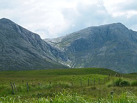
 벤코르(왼쪽)와 그 자회사가 정점을 찍고, 두 개의 동풍이 로프 이나흐를 가로지른다. | |
| 최고점 | |
| 표고 | 711m(2,333ft)[1] |
| 두각을 나타남 | 306m(1,004ft)[1] |
| 목록 | 100개의 가장 높은 아일랜드 산맥, 마릴린, 휴이트, 아르데린, 심엠, 반델리에르-리남 |
| 좌표 | 53°30°N 9°48°W/53.500°N 9.800°W좌표: 53°30′N 9°48′W / 53.500°N 9.800°W/ [1] |
| 이름 지정 | |
| 영어 번역 | 뾰족한 봉우리 |
| 이름 언어 | 아일랜드어 |
| 지리 | |
 벤코르 아일랜드 | |
| 위치 | 아일랜드 갤웨이 |
| 상위 범위 | 십이벤스 |
| OSI/OSNI 그리드 | L8116652200 |
| 토포 지도 | OSi Discovery 37 |
| 지질학 | |
| 암석 종류 | 옅은 석영석, 그릿, 그래피티틱 상단 암반[1] |
벤코르(Irish: Binn Chorr, 'Pointed Peakes'[2]란 뜻)는 711m(2,333ft)로 아일랜드에서 82번째로 높은 봉우리,[3] 반델레르-리남 눈금으로는 102번째로 높은 봉우리다.[4][5]벤코르는 아일랜드 갈웨이에 있는 코네마라 국립공원에 있는 12벤스 산맥의 핵심 마사지의 중심에 위치해 있다.벤바운 729m(2,392ft)에 이어 12벤스 산맥에서 두 번째로 높은 산으로 벤바운과 가까운 곳에 위치해 있으며 벤콜라그뒤프 696m(2,283ft)의 산맥에서 세 번째로 높은 산과 마우미나(Maumina)의 콜만으로 분리되어 있다.[5][6]
이름 지정
아일랜드 학계 폴 템펀에 따르면 영국의 지도제작자 팀 로빈슨은 산을 '큰 고리의 절정'이라는 뜻의 아일랜드어: Binn an Choire Mhuir라는 대체 명칭을 제안했지만, Tempan은 Bencorr의 기존 OS 지도 이름이 정확한 버전이라는 데 동의했다.[2]Tempan records that the British army sappers set up a beacon on Bencorr during the first Ordnance Survey of Ireland in the 1830s (i.e. the 6" map series), and that it is said that the subsidiary peak of Irish: Binn an tSaighdiúra (translation, the "soldier's peak") was named after one of the sappers who fell to his death from the mountain.[2]
지리
벤코르는 자체 미니 매시프에 앉아 있으며 690m(2,260ft)에 있는 벤코르 노스탑과 짧은 높은 바위 능선으로 연결되어 있어 멀리서 볼 때 벤코르에게 '이중 정상회담'의 프로필을 제공한다.One of Bencorr's more distinctive features is its long rocky north-easterly spur, known as Carrot Ridge (Irish: Meacan Buí), on which sits the subsidiary peaks of Binn an tSaighdiúra 653 metres (2,142 ft) (whose prominence of only eight metres, making it an easy peak to miss), and at the far end of the spur, Bencorrbeg 577 metres (1,893 ft).[5][7]
Bencorr (그리고 Bencorr North Top)은 두 개의 주요 빙하 U자 모양의 계곡이 만나는 지점에 놓여 있다.[6][8]북동쪽으로는 글레니나흐 계곡(Irish: Glean Eidhneach)이 있는데, 글레니나흐 강은 글레니나흐 강이 흐르는 곳이며, 벤코르의 서쪽으로는 글렌코한 강의 빙하계곡으로 여러 개의 벤스가 경계를 이루고 있다.[5][7][8]
Bencorr has two eastern corries, the southern and larger corrie lies between the summit of Derryclare and Bencorr and is known as Irish: Log an Choire Mhóir (meaning "wood of the big corrie"); while the northern and smaller corrie lies between the summit of Bencorr and Bencorr North Top and is known as Irish: Log an Choire Bhig (meaning "wood of the small corrie").두 개의 산호리는 모두 데리클레어 우드와 러프 이나그로 이어진다.[5][7]
벤코르가 306m(1,004ft)로 두각을 나타낸 것은 마릴린(Marilyn)에 해당하며, 최소 두각기준이 100m인 마운틴뷰즈 온라인 데이터베이스(MountainViews Online Database)에서 아일랜드에서 48번째로 높은 산으로 평가되기도 한다.[5][9]
힐 워킹
마우미나 계곡으로 올라가거나, 벤코르베그를 먼저 등반한 다음 당근 능선을 횡단하여 정상까지 가는 방법으로 벤코르를 오르는 가장 간단한 길. 두 노선은 모두 9km 이상, 4~5시간 이상 걷는 길이다.[10]
더 큰 말발굽형 경로는 데리클레어와 벤코르의 11~14km, 5~7시간 회로로부터 형성될 수 있으며, 두 코리 사이에 있는 벤코르의 작은 돌기를 하강시키거나, 벤코르 노스탑까지 계속하여 캐럿 리지를 통해 하강할 수 있다.[7]
벤코르는 또한 아일랜드 최고의 산등성이 중 하나로 여겨지는 인기 있는 16km, 8~9시간 글렌코한 호스슈의 일부로 올라간다.[8][11]또한, 벤코르는 글레니나 강 주변의 15km, 8~9시간 경로인 글레니나흐 호스슈(Gleninah Horshoe)의 일부로 올라간다.[10]
암벽등반

벤코르의 북동쪽 암석 스퍼인 캐럿 리지는 디프(D)부터 매우 심각(VS)까지 등급이 다양하고 길이가 150~320m에 이르는 멀티 피치 록 클라이밍으로 코네마라에서 중요한 암석 클라이밍장이다.[12]클래식한 등산로는 캐럿 리지(275m D)와 세븐 헤븐(330m HS)이 있다.[12]
Tempan 기록이 당근에 기록하는 바 1933년으로 캠브리지 대학에서 학생들에 의해 올라갔다, 하지만 길(그리고 전체 능선)"당근 리지"아일랜드 등산가이다 조스 Lynam는 실수로 약을 거점 중 1949년에 그들의 등정은 최초의 등정이라고 믿었습니다에 의해서 이름이 지어졌다,[2]는 아일랜드:Meacan Buí은 단순히 보강.ct당근 능선의 [2]번역
The large easterly corrie between the summits of Derryclare and the summit of Bencorr, Irish: Log an Choire Mhóir (meaning "wood of the big corrie"), also contains several large 200 metre multi-pitch graded rock climbs at grades of Diff (D) to Very Diff (VD), the most notable of which is The Knave (VD, 225 m); and the smaller corrie between the sum벤코르의 미트와 벤코르 노스탑의 아일랜드 정상: "작은 코리의 나무"라는 뜻의 로지 앤 처어 비그(Log an Choire Bhig)는 코너 라이크(VS 4c, 30m)를 포함해 짧지만 힘든 등반을 많이 한다.[13]
갤러리
당근 리지, 벤코르베그(l), 빈(binn an Saighdiura) 및 벤코르 N 탑(r)

Benbaun에서 Bencollaghduff(c)까지, 그리고 Bencorr 및 Derryclare 뒤쪽의 능선까지 보기

Lough Inagh, Derryclare (l), Bencorr (c), Bencorr N Top (r)


_and_Bencorr_(right)_from_north_col_of_Derryclare.jpg)
참고 문헌 목록
- Fairbairn, Helen (2014). Ireland's Best Walks: A Walking Guide. Collins Press. ISBN 978-1848892118.
- MountainViews Online Database (Simon Stewart) (2013). A Guide to Ireland's Mountain Summits: The Vandeleur-Lynams & the Arderins. Collins Books. ISBN 978-1-84889-164-7.
- Paul Phelan (2011). Connemara & Mayo - A Walking Guide: Mountain, Coastal & Island Walks. Collins Press. ISBN 978-1848891029.</ref>
- Dillion, Paddy (2001). Connemara: Collins Rambler's guide. Harper Collins. ISBN 978-0002201216.
- Dillion, Paddy (1993). The Mountains of Ireland: A Guide to Walking the Summits. Cicerone. ISBN 978-1852841102.
참고 항목
| 위키미디어 커먼즈에는 벤코르와 관련된 미디어가 있다. |
- 십이벤스
- 킬러리 하버의 주요 레인지인 음웨레아
- 코네마라에서 주요 사정거리인 맘투르크
- 아일랜드의 산 목록
- 영국 제도의 산과 언덕 목록
- 영국의 마릴린스 섬 목록
- 잉글랜드, 웨일스, 아일랜드의 휴이트 산 목록
참조
- ^ a b c d "Bencorr". MountainViews Online Database. Retrieved 31 July 2019.
- ^ a b c d e Paul Tempan (February 2012). "Irish Hill and Mountain Names" (PDF). MountainViews.ie.
- ^ Simon Stewart (October 2018). "Arderins: Irish mountains of 500+m with a prominence of 30m". MountainViews Online Database.
- ^ Simon Stewart (October 2018). "Vandeleur-Lynams: Irish mountains of 600+m with a prominence of 15m". MountainViews Online Database.
- ^ a b c d e f 마운틴뷰(2013년 9월), "아일랜드 마운틴 서밋 가이드:반델레우르-리남스 & 아르데린스' 콜린스 북스, 코르크, ISBN 978-1-84889-164-7
- ^ a b Dillion, Paddy (2001). Connemara: Collins Rambler's guide. Harper Collins. ISBN 978-0002201216.
- ^ a b c d Paul Phelan (2011). Connemara & Mayo - A Walking Guide: Mountain, Coastal & Island Walks. Collins Press. ISBN 978-1848891029.
Route 10: Derryclare and Bencorr
- ^ a b c Helen Fairbairn (30 December 2014). Ireland's Best Walks: A Walking Guide (Walking Guides). Collins Press. ISBN 978-1848892118.
ROUTE 34: The Glencoaghan Horseshoe. A true classic
- ^ "Irish Highest 100: The highest 100 Irish mountains with a prominence of +100m". MountainViews Online Database. September 2018.
- ^ a b Dillion, Paddy (2001). Connemara: Collins Rambler's guide. Harper Collins. ISBN 978-0002201216.
Walk 28: Gleann Eidhneach Horseshoe
- ^ Dillion, Paddy (2001). Connemara: Collins Rambler's guide. Harper Collins. ISBN 978-0002201216.
Walk 30: Gleann Chóchan Horseshoe
- ^ a b "Glenn Eighneach". Irish Climbing Wiki.
The finest rock formations in the Twelve Bens are found in the south wall of Gleann Eidheanach (Glen Inagh), running from Binn an Choire Bhig to Mám na bFhonsaí, east of Binn Dubh (L808530).
- ^ "Inagh Valley: Log an Choire Mhóir, Log and Choire Bhig". Irish Online Climbing Wiki. Retrieved 1 August 2019.
외부 링크
- 마운틴뷰즈: 벤코르 아일랜드 마운틴 웹사이트
- 마운틴뷰: 아일랜드 온라인 마운틴 데이터베이스
- 영국식 섬 산의 가장 큰 데이터베이스인 영국과 아일랜드식 언덕 데이터베이스("DoBIH")
- Hill Bagging UK & Areland, DoB의 검색 가능한 인터페이스IH
| 브리티시 섬 |  | |
|---|---|---|
| 스코틀랜드 | ||
| 스코틀랜드 외곽 | ||
| 잉글랜드 | ||
| 아일랜드 | ||
| 카운티 탑 | ||

.jpg)