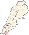
프라운
Froun프라운 فرون | |
|---|---|
마을 | |
| 좌표:33°17′49″N 35°25°43″E/33.29694°N 35.42861°E좌표: 33°17′49″N 35°25′43″E / 33.29694°N 35.42861°E/ | |
| 격자위치 | 151/121 L |
| 나라 | |
| 주 | 나바티에 |
| 구 | 빈트제이빌 |
| 표고 | 720m(2,360ft) |
| 시간대 | UTC+2(EET) |
| • 여름(DST) | UTC+3(EEST) |
| 다이얼링 코드 | +961 |
프라운(아랍어: فرون)은 레바논 남부 빈트제빌 구에 있는 마을이다.
이름
E. H. 팔머에 따르면, 푸르옌이라는 이름은 "오븐" 또는 "저수지"[1]에서 유래했다.
역사
1881년, PEF의 서팔레스타인 조사(SWP)는 "100개의 메타위레가 있는 돌로 지어진 마을로, 언덕 위에 위치하고 작은 정원과 경작 가능한 땅으로 둘러싸여 있다"고 설명했다.물은 바위로 깎은 시스테르에서 공급된다."[2]
참조
참고 문헌 목록
- Conder, C.R.; Kitchener, H.H. (1881). The Survey of Western Palestine: Memoirs of the Topography, Orography, Hydrography, and Archaeology. Vol. 1. London: Committee of the Palestine Exploration Fund.
- Palmer, E.H. (1881). The Survey of Western Palestine: Arabic and English Name Lists Collected During the Survey by Lieutenants Conder and Kitchener, R. E. Transliterated and Explained by E.H. Palmer. Committee of the Palestine Exploration Fund.


