다운스 빙하
Downes Glacier| 다운스 빙하 | |
|---|---|
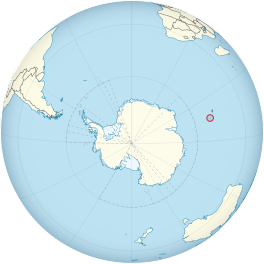
 허드 섬과 맥도날드 섬의 지구상 위치 | |
| 유형 | 조수 |
| 위치 | 허드 섬 허드 섬과 맥도날드 제도 영토 호주. |
| 좌표 | 53°2†S 73°31°E/53.033°S 73.517°E |
| 두께 | 약 55미터 |
| 종착륙장 | Mechanics Bay, Saddle Point와 Cape Bidlingmaier 사이 |
| 상황 | 후퇴하다[1][2][3][4][5] |
다운스 빙하(53°2)【S 73°31】E/53.033°S 73.517° 73.)은 인도양 남부 허드섬 북쪽에 있는 만조빙하이다.그것은 북상하여 비들링마이어 곶 양쪽에서 허드 [6][7]섬의 북쪽 해안으로 흐릅니다.다운스 빙하의 동쪽에는 Ealey 빙하가 있으며, 종점은 케이프 비들링마이어 남동쪽 근처에 있습니다.다운스 빙하의 서쪽에는 챌린저 빙하가 있는데, 챌린저 빙하의 종점은 코린트 만 동쪽, 새들 포인트에서 가까운 서쪽에 위치해 있습니다.새들 포인트는 다운스 빙하와 챌린저 빙하를 분리합니다.
검출 및 명명
1948년 ANARE(호주 국립 남극 연구 탐험대)에 의해 조사되었다.1951년과 1963년에 허드 섬의 ANARE 생물학자 [6][7]M.C. 다운스를 위해 호주 남극명위원회(ANCA)에 의해 명명되었습니다.
레퍼런스
- ^ Ian F. Allison; Peter L. Keage (1986). "Recent changes in the glaciers of Heard Island". Polar Record. 23 (144): 255–272. doi:10.1017/S0032247400007099.
- ^ Andrew Ruddell (25 May 2010). "Our subantarctic glaciers: why are they retreating?". Glaciology Program, Antarctic CRC and AAD. Archived from the original on 2 October 2009. Retrieved 5 June 2010.
- ^ Quilty, P.G.; Wheller, G. (2000). "Heard Island and the McDonald Islands: A window into the Kerguelen Plateau (Heard Island Papers)". Pap. Proc. R. Soc. Tasm. 133 (2): 1–12.
- ^ Budd, G.M. (2000). "Changes in Heard Island glaciers, king penguins and fur seals since 1947 (Heard Island Papers)". Pap. Proc. R. Soc. Tasm. 133 (2): 47–60.
- ^ Douglas E. Thost; Martin Truffer (February 2008). "Glacier Recession on Heard Island, Southern Indian Ocean". Arctic, Antarctic, and Alpine Research. 40 (1): 199–214. doi:10.1657/1523-0430(06-084)[THOST]2.0.CO;2. Archived from the original on 4 December 2012. Retrieved 7 June 2010.
- ^ a b "Downes Glacier". Geographic Names Information System. United States Geological Survey. Retrieved 5 June 2010.
- ^ a b "Downes Glacier". Australian Antarctic Data Centre. Retrieved 5 June 2010.
추가 정보
- U. Radok; D. Watts (1975). "A synoptic background to glacier variations of Heard Island" (PDF). Snow and Ice (Proceedings of the Moscow Symposium, August 1971) (104 ed.). Wallingford, Oxfordshire, UK: International Association of Hydrological Sciences. pp. 42–56. Retrieved 7 June 2010.
- Truffer, M.; Thost, D; Ruddell, A (2001). "The Brown Glacier, Heard Island: its morphology, dynamics, mass balance and climate setting". Antarctic CRC Research Report No. 24. Hobart, Tasmania: Cooperative Research Centre for the Antarctic and Southern Ocean Environment, University of Tasmania. pp. 1–27.
- Kevin Kiernan; Anne McConnell (2002). "Glacier retreat and melt-lake expansion at Stephenson Glacier, Heard Island World Heritage Area" (PDF). Polar Record. 38 (207): 297–308. doi:10.1017/S0032247400017988. Retrieved 7 June 2010.
외부 링크
- 허드 섬과 맥도날드 섬의 지도를 보려면 여기를 클릭하세요. 주요 지형도 모두 포함되구요.
- 오스트레일리아 남극 지구
- 오스트레일리아 남극 가제터
- 남극 복합 가제터
- 호주 남극명훈장위원회(AANMC)
- 미국 지질조사국, 지명정보시스템(GNIS)
- 남극 연구 과학 위원회
![]() 이 문서에는 미국 지질조사 문서의 퍼블릭 도메인 자료가 포함되어 있습니다. (지리명 정보 시스템의 내용) 좌표: 53°2【S73°31】E/53.033°S 73.517°.517
이 문서에는 미국 지질조사 문서의 퍼블릭 도메인 자료가 포함되어 있습니다. (지리명 정보 시스템의 내용) 좌표: 53°2【S73°31】E/53.033°S 73.517°.517

