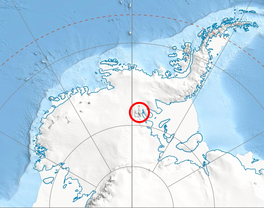
엘렌 빙하
Ellen Glacier| 엘렌 빙하 | |
|---|---|
 남극 서부의 센티넬 산맥 위치 | |
남극 엘렌 빙하의 위치 | |
| 위치 | 엘즈워스 랜드 |
| 좌표 | 78°13°S 84°30°W / 78.217°S 84.500°W |
| 길이 | 22해리(41km, 25mi) |
| 두께 | 알 수 없는 |
| 터미네이터스 | 러트퍼드 아이스 스트림 |
| 상태 | 알 수 없는 |
엘렌 빙하는 남극 엘즈워스 산맥의 센티넬 산맥 중앙의 빙하다. 앤더슨 산과 롱 게이블의 동쪽 경사면을 배수하며 일반적으로 남동쪽으로 22해리(41km, 25mi)를 흐르며 반스 리지까지 흐르며, 여기서 사거리를 벗어나 남쪽으로 흐르는 러트포드 아이스 스트림으로 들어간다.
It was first mapped by the United States Geological Survey from surveys and U.S. Navy air photos, 1957–59, and was named by the Advisory Committee on Antarctic Names for Lieutenant Colonel Cicero J. Ellen of the U.S. Air Force, who was in command of many of the air operations when the South Pole Station was established by air drop in the 1956–57 season에[1]
지류 빙하
참고 항목
외부 링크
- 엘렌 빙하. 코퍼닉스 위성 이미지
참조
- ^ "Ellen Glacier". Geographic Names Information System. United States Geological Survey. Retrieved 2012-02-28.
 이 문서에는 미국 지질조사국(Geographic Names Information System)의 공용 도메인 자료가 통합되어 있다.
좌표: 78°13′S 84°30′W / 78.217°S 84.500°W/


