드 헤이븐 빙하
De Haven Glacier남극의 빙하
| 드 헤이븐 빙하 | |
|---|---|
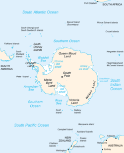
 윌크스 랜드가 약간 오른쪽에 있는 남극 지도 | |
남극의 드 헤이븐 빙하의 위치 | |
| 위치 | 윌크스 랜드 |
| 좌표 | 67°03′00″S 127°32′00″E / 67.05,000°S 127.53333°E / -67.05000; 127.53333 |
| 두께 | 알 수 없는 |
| 터미네이터스 | 포르푸아즈 만 |
| 상태 | 알 수 없는 |
드 헤이븐 빙하(67°3)′S 127°32′E / 67.050°S 127.533°E / -67.050; 127.533좌표: 67°3′S 127°32′E / 67.050°S 127.533°E / -67.050; 127.533)은 포르푸아즈 만의 남서쪽 구석으로 흐르는 넓은 빙하다. It was delineated by G.D. Blodgett (1955) from aerial photographs taken by U.S. Navy Operation Highjump (1946–47), and was named by the Advisory Committee on Antarctic Names for Edwin De Haven, Acting Master on the sloop Vincennes during the United States Exploring Expedition (1838–42) under Lieutenant Charles Wilkes.
참고 항목
참조
 이 글은 미국 지질조사국(US Geogical Survey) 문서의 공용 도메인 자료를 통합한 것이다. "De Haven Glacier". (지리학적 이름 정보 시스템의 내용)
윌크스 랜드의 빙하 | |
|---|---|


