코나발라
Conavalla| 클로나발라 | |
|---|---|
| 첸안발라이 | |
 글렌달로 상류 호수의 해안에서 본 코나발라의 마시프(센트레) | |
| 최고점 | |
| 표고 | 734m(2,408ft)[1] |
| 두각을 나타남 | 109m(358ft)[1] |
| 목록 | 100개의 가장 높은 아일랜드 산맥, 휴이트, 아르데린, 심, 밴델리에르-리남 |
| 좌표 | 53°00′55″N 6°27′9″W/53.01528°N 6.45250°W좌표: 53°00′55″N 6°27′9″W / 53.01528°N 6.45250°W/ |
| 이름 지정 | |
| 영어 번역 | 길목이나 고갯길 |
| 이름 언어 | 아일랜드어 |
| 지리 | |
 클로나발라 아일랜드의 위치 | |
| 위치 | 위클로우, 아일랜드 |
| 상위 범위 | 위클로우 산맥 |
| OSI/OSNI 그리드 | T023959 |
| 토포 지도 | OSi Discovery 56 |
| 지질학 | |
| 산형 | 다크 슬레이트-시스트, 쿼트자이트 & 코티쿨레[1] |
코나발라(Irish: Ceann an Bhealaigh, '도로의 머리 또는 고개'[2]라는 뜻)는 734m(2,408ft)로 아일랜드에서 69번째로 높은 봉우리,[3] 반델레르-리남 척도에서는 85번째로 높은 봉우리다.[4][5]코나발라 정상은 북쪽의 키푸레에서 남쪽의 루그나퀼리아까지 이어지는 아일랜드 위클로 산맥의 주요 "중앙 척추" 바로 옆에 위치해 있다.[6][5]코나발라의 북동쪽으로의 커다란 마시프는 글렌달로프 계곡의 머리와 글렌말루 계곡의 위쪽 동쪽을 다양한 어깨가 지배하는 "습하고 보기 드문 불모지 평원"으로 묘사된다.[6][5]
이름 지정
Irish academic Paul Tempan notes that the "pass" element of Conavalla's name likely refers to the various routes from the Blessington lakes area (e.g. the R756 road to the Wicklow Gap) in the west that crossed parts of Conavalla's boggy massif to get into the Glenmalure valley in the east (note that the Wicklow Gap can be used to access the neighbo코나발라의 마시프를 건널 필요 없이 글렌달로 골짜기를 울린다.[2](아래 § 아트 O'Neill 참조).
지리
컨발라는 위클로우 산맥 산맥의 남쪽 구역에 위치해 있으며, 글렌말루 계곡의 맨 앞에 있는 "보기" 마시프 위에 말굽을 형성하고 있으며, 이웃인 테이블 마운틴 702미터(2,303피트), 카메나볼로겐 758미터(2,487피트)와 함께 있다.[6]
코나발라는 또한 글렌달로 계곡 주변의 또 다른 넓은 말발굽에 자리잡고 있는데, 터러프 힐의 수력 발전소는 681미터(2,234피트)이고 카마데리 산은 699미터(2,293피트), 루그두프 652미터(2,139피트), 물라코르 661미터(2,169피트)의 산이다.[5]코나발라의 대형 '보그미시프'는 계곡의 머리의 서쪽 끝자락에 있는 정상에서 동쪽 650m(2,130ft)에 이르는 글렌달로 계곡의 머리를 지배하고 있다.[6]이 마사회는 또한 코나발라 정상 북쪽에 있는 3호수 620미터(2,030피트)도 포함한다.[6]
코나발라가 109m(358ft)로 두각을 나타낸 것은 마릴린으로 인정받지 못하지만, 최소 두각기준이 100m인 마운틴뷰즈 온라인 데이터베이스(MountainViews Online Database)에서 아일랜드에서 39번째로 높은 산으로 평가된다.[7][5]
아트 오닐
On Conavalla's northern slopes lies Art's Cross and Art's Plaque, dedicated to Art O'Neill, the brother of Hugh O'Neill, Earl of Tyrone, who died of exposure in January 1592 helping Hugh Roe O'Donnell to escape from Dublin Castle to the stronghold of Fiach McHugh O'Byrne in the valley of Glenmalure.[8]
참고 문헌 목록
- Fairbairn, Helen (2014). Dublin & Wicklow: A Walking Guide. Collins Press. ISBN 978-1848892019.
- Fairbairn, Helen (2014). Ireland's Best Walks: A Walking Guide. Collins Press. ISBN 978-1848892118.
- MountainViews Online Database (Simon Stewart) (2013). A Guide to Ireland's Mountain Summits: The Vandeleur-Lynams & the Arderins. Collins Books. ISBN 978-1-84889-164-7.
- Dillion, Paddy (1993). The Mountains of Ireland: A Guide to Walking the Summits. Cicerone. ISBN 978-1852841102.
갤러리

서밋 케언

삼호
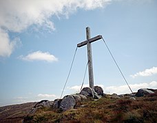
아트 오닐의 십자가

테이블 마운틴에서 서밋

러프 퍼리브

코나발라 마시프


참고 항목
| 위키미디어 커먼즈에는 코나발라와 관련된 미디어가 있다. |
참조
- ^ a b c "Conavalla". MountainViews Online Database. Retrieved 8 February 2019.
- ^ a b Paul Tempan (February 2012). "Irish Hill and Mountain Names" (PDF). MountainViews.ie.
- ^ Simon Stewart (October 2018). "Arderins: Irish mountains of 500+m with a prominence of 30m". MountainViews Online Database.
- ^ Simon Stewart (October 2018). "Vandeleur-Lynams: Irish mountains of 600+m with a prominence of 15m". MountainViews Online Database.
- ^ a b c d e 마운틴뷰(2013년 9월), "아일랜드 마운틴 서밋 가이드:반델레우르-리남스 & 아르데린스' 콜린스 북스, 코르크, ISBN 978-1-84889-164-7
- ^ a b c d e Dillion, Paddy (1993). The Mountains of Ireland: A Guide to Walking the Summits. Cicerone. ISBN 978-1852841102.
Walk 8: Mullacor, Lugduff, Conavalla
- ^ "Irish Highest 100: The highest 100 Irish mountains with a prominence of +100m". MountainViews Online Database. September 2018.
- ^ Frank McNally (14 January 2017). "Hardship for Art's Sake – An Irishman's Diary about the Art O'Neill Challenge". Irish Times. Retrieved 18 July 2019.
외부 링크
- 마운틴뷰: 코나발라 아일랜드 마운틴 웹사이트
- 마운틴뷰: 아일랜드 온라인 마운틴 데이터베이스
- 영국식 섬 산의 가장 큰 데이터베이스인 영국과 아일랜드식 언덕 데이터베이스("DoBIH")
- Hill Bagging UK & Areland, DoB의 검색 가능한 인터페이스IH
| 브리티시 섬 |  | |
|---|---|---|
| 스코틀랜드 | ||
| 스코틀랜드 외곽 | ||
| 잉글랜드 | ||
| 아일랜드 | ||
| 카운티 탑 | ||

.jpg)


