나막신
Cloghernagh| 나막신 | |
|---|---|
| 클로차너치 | |
 아트 러프의 나막신 산 | |
| 최고점 | |
| 표고 | 800m(2,600ft)[1] |
| 두각을 나타남 | 15m(49ft)[1] |
| 목록 | 반델레우르 리남 |
| 좌표 | 52°58˚N 6°26′W/52.967°N 6.433°W좌표: 52°58′N 6°26′W / 52.967°N 6.433°W[1] |
| 이름 지정 | |
| 영어 번역 | 거추장스러운 곳 |
| 이름 언어 | 아일랜드어 |
| 지리 | |
 나막신 아일랜드의 위치 | |
| 위치 | 위클로우, 아일랜드 |
| 상위 범위 | 위클로우 산맥 |
| OSI/OSNI 그리드 | T058918[1] |
| 토포 지도 | OSi Discovery 56 |
| 지질학 | |
| 산형 | 결이 촘촘하고 무스코바이트가 풍부한 아플로그라나이트 기반암[1] |
800m(2,600ft)의 나막신(Irish: Clocharnach, '스토니 플레이스'[2]라는 뜻)은 아르데린으로 출전할 수 있는 [3]두각을 나타내지 못하지만 반델레르-리남 눈금에서 40번째로 높은 봉우리라는 두각을 나타내고 있다.[4][5]나막hernah는 위클로 산맥 산맥의 남쪽 구역에 위치해 있으며, 위클로의 가장 높은 산인 루그나퀴야 925미터(3,035피트)의 대형 마시프의 일부다.[6][7]
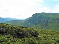
나막hernah의 북쪽은 Fraughan Rock Glen의 경치 좋은 U자 모양의 매달려 있는 계곡의 가파른 남쪽 벽과 절벽들을 형성하고 있는데, 그 계곡은 그 아래 글렌말루 계곡으로 떨어진다; 그 경치 좋은 높은 코리호수인 Arts Lough는 북쪽 옆구리에 높이 511미터(1,677피트)가 놓여 있다.[7][6]Cloghernagh forms a "horseshoe" around the Fraughan Rock Glen with Lugnaquillia and Benleagh 689 metres (2,260 ft), and another "horseshoe shape" around the glen of the Carrawaystick River with Corrigasleggaun 794 metres (2,605 ft), and the corrie lake of Kelly's Lough.[8][7]
참고 문헌 목록
- Fairbairn, Helen (2014). Ireland's Best Walks: A Walking Guide. Collins Press. ISBN 978-1848892118.
- Fairbairn, Helen (2014). Dublin & Wicklow: A Walking Guide. Collins Press. ISBN 978-1848892019.
- MountainViews Online Database (Simon Stewart) (2013). A Guide to Ireland's Mountain Summits: The Vandeleur-Lynams & the Arderins. Collins Books. ISBN 978-1-84889-164-7.
- Dillion, Paddy (1993). The Mountains of Ireland: A Guide to Walking the Summits. Cicerone. ISBN 978-1852841102.
갤러리

벤글라 북쪽으로 보기
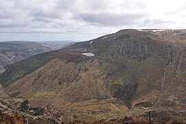
Benleah의 Blachernah와 Arts Lough

Fraughan Rock Glen 동쪽을 Blachernah(오른쪽)로 보기
Benleah의 Blachernah와 Arts Lough


참고 항목
| 위키미디어 커먼즈에는 나막신 관련 미디어가 있다. |
참조
- ^ a b c d e "Cloghernagh". MountainViews Online Database. Retrieved 27 July 2019.
- ^ Paul Tempan (February 2012). "Irish Hill and Mountain Names" (PDF). MountainViews.ie.
- ^ Simon Stewart (October 2018). "Arderins: Irish mountains of 500+m with a prominence of 30m". MountainViews Online Database.
- ^ Simon Stewart (October 2018). "Vandeleur-Lynams: Irish mountains of 600+m with a prominence of 15m". MountainViews Online Database.
- ^ 마운틴뷰(2013년 9월), "아일랜드 마운틴 서밋 가이드:반델레우르-리남스 & 아르데린스' 콜린스 북스, 코르크, ISBN 978-1-84889-164-7
- ^ a b Dillion, Paddy (1993). The Mountains of Ireland: A Guide to Walking the Summits. Cicerone. ISBN 978-1852841102.
Walk 10: Ballineddan Mountain, Slievemaan, Lugnaquillia, Camenabologue East Top, Camenabologue
- ^ a b c Fairbairn, Helen (2014). Ireland's Best Walks: A Walking Guide. Collins Press. ISBN 978-1848892118.
Route 65: Lugnaquilla
- ^ Fairbairn, Helen (2014). Dublin & Wicklow: A Walking Guide. Collins Press. ISBN 978-1848892019.
외부 링크
- MountainViews: 아일랜드 마운틴 웹사이트, Blachernagh
- 마운틴뷰: 아일랜드 온라인 마운틴 데이터베이스
- 영국식 섬 산의 가장 큰 데이터베이스인 영국과 아일랜드식 언덕 데이터베이스("DoBIH")
- Hill Bagging UK & Areland, DoB의 검색 가능한 인터페이스IH
| 브리티시 섬 |  | |
|---|---|---|
| 스코틀랜드 | ||
| 스코틀랜드 외곽 | ||
| 잉글랜드 | ||
| 아일랜드 | ||
| 카운티 탑 | ||

.jpg)