벤글레아
Benleagh| 벤글레아 | |
|---|---|
| 빈 리아스 | |
 | |
| 최고점 | |
| 표고 | 689m(2,520ft)[1] |
| 두각을 나타남 | 24m(79ft)[1] |
| 목록 | 반델레우르 리남 |
| 좌표 | 좌표:52°59′19″N 6°27′15″w/52.98861°N 6.45417°W |
| 이름 지정 | |
| 영어 번역 | 회색 봉우리 |
| 이름 언어 | 아일랜드어 |
| 지리 | |
 벤글레아 아일랜드의 위치 | |
| 위치 | 위클로우, 아일랜드 |
| 상위 범위 | 위클로우 산맥 |
| OSI/OSNI 그리드 | T038941[1] |
| 토포 지도 | OSi Discovery 56 |
| 지질학 | |
| 산형 | 아피릭 그라노다이오라이트 베드록[1] |
689m(2,260ft)의 벤레아흐(이리쉬:Binn Liath, '그레이 피크'[2]라는 뜻)는 아르데린으로 출전할 만한 위력은 없지만 그 [3]위력은 반델레르-리남 척도에서 125번째로 높은 봉우리에 오를 수 있다.[4][5]Benlah는 Wicklow 산맥의 남쪽 구역에 위치해 있으며, Wicklow에서 가장 높은 산인 925m (3,035ft) 루그나킬라의 거대한 마시프의 일부분이다.[6]
Benleagh's southern flank forms the steep walls and cliffs of the hanging valley of Fraughan Rock Glen, which then falls into the U-shaped valley of Glenmalure below; Benleagh forms a "horseshoe" around the Fraughan Rock Glen with Lugnaquillia at its apex and Cloghernagh 800 metres (2,600 ft), to the south.[7]벤글라흐는 또한 남쪽의 루그나퀴야와 북쪽의 카메나볼로게와 테이블 마운틴을 잇는 넓은 '스핀'에 앉아 있는데, 그것은 이마알의 글렌을 원을 그리며 돌고 있다.[6][8]
참고 문헌 목록
- Fairbairn, Helen (2014). Dublin & Wicklow: A Walking Guide. Collins Press. ISBN 978-1848892019.
- Fairbairn, Helen (2014). Ireland's Best Walks: A Walking Guide. Collins Press. ISBN 978-1848892118.
- MountainViews Online Database (Simon Stewart) (2013). A Guide to Ireland's Mountain Summits: The Vandeleur-Lynams & the Arderins. Collins Books. ISBN 978-1-84889-164-7.
- Dillion, Paddy (1993). The Mountains of Ireland: A Guide to Walking the Summits. Cicerone. ISBN 978-1852841102.
갤러리
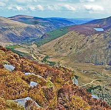
Benleah 정상에서 남동쪽 보기

Benleagh(왼쪽) 및 Blachernah(오른쪽)와 함께 Fraugan Rock Glen을 가로질러 동쪽으로 보기


참고 항목
| 위키미디어 커먼즈에는 벤글라흐와 관련된 미디어가 있다. |
참조
- ^ a b c d "Benleagh". MountainViews Online Database. Retrieved 8 February 2019.
- ^ Paul Tempan (February 2012). "Irish Hill and Mountain Names" (PDF). MountainViews.ie.
- ^ Simon Stewart (October 2018). "Arderins: Irish mountains of 500+m with a prominence of 30m". MountainViews Online Database.
- ^ Simon Stewart (October 2018). "Vandeleur-Lynams: Irish mountains of 600+m with a prominence of 15m". MountainViews Online Database.
- ^ 마운틴뷰(2013년 9월), "아일랜드 마운틴 서밋 가이드:반델레우르-리남스 & 아르데린스' 콜린스 북스, 코르크, ISBN 978-1-84889-164-7
- ^ a b Dillion, Paddy (1993). The Mountains of Ireland: A Guide to Walking the Summits. Cicerone. ISBN 978-1852841102.
Walk 10: Ballineddan Mountain, Slievemaan, Lugnaquillia, Camenabologue East Top, Camenabologue
- ^ Fairbairn, Helen (2014). Ireland's Best Walks: A Walking Guide. Collins Press. ISBN 978-1848892118.
Route 65: Lugnaquilla
- ^ Fairbairn, Helen (2014). Dublin & Wicklow: A Walking Guide. Collins Press. ISBN 978-1848892019.
외부 링크
- 마운틴뷰즈: Benleah의 아일랜드 마운틴 웹사이트
- 마운틴뷰: 아일랜드 온라인 마운틴 데이터베이스
- 영국식 섬 산의 가장 큰 데이터베이스인 영국과 아일랜드식 언덕 데이터베이스("DoBIH")
- Hill Bagging UK & Areland, DoB의 검색 가능한 인터페이스IH
| 브리티시 섬 |  | |
|---|---|---|
| 스코틀랜드 | ||
| 스코틀랜드 외곽 | ||
| 잉글랜드 | ||
| 아일랜드 | ||
| 카운티 탑 | ||

.jpg)


